Discover the cosmos! Each day a different image or photograph of our fascinating universe is featured, along with a brief explanation written by a professional astronomer.
M83: The Southern Pinwheel
Explanation: Beautiful and bright spiral galaxy M83 lies some twelve million light-years away, near the southeastern tip of the very long constellation Hydra. Prominent spiral arms traced by dark dust lanes and blue star clusters lend this galaxy its popular name, the Southern Pinwheel. Still, reddish star forming regions that dot this cosmic pinwheel’s spiral arms have suggested another nickname, the Thousand-Ruby Galaxy. A mere 40,000 light-years across, smaller than the Milky Way, M83 is a member of a group of galaxies that includes active galaxy Centaurus A. In fact, the core of M83 itself is bright at x-ray energies, showing a high concentration of neutron stars and black holes left from an intense burst of star formation. This sharp, groundbased telescopic view also features foreground Milky Way stars and distant background galaxies.
The curving, parallel mountain ridges of the Sierra Madre Oriental are an eye-catching feature of northeastern Mexico’s landscape. The spot where these folds nestle up against Mexico’s second-largest metropolitan area captured the attention of an astronaut aboard the International Space Station, who took this photo on August 26, 2026.
Monterrey, the capital of the state of Nuevo León, is an industrial hub supporting heavy industries such as ironworks and steelworks, as well as manufacturing facilities for goods ranging from textiles to processed foods to glass and plastics. The metropolitan area is home to 5.3 million people, according to the 2020 census. And while the city has seen overall population growth since 1990, the number of people living within 5 kilometers (3 miles) of the city center has declined, researchers have found—a trajectory shared with many of Mexico’s metropolitan areas.
In Monterrey’s case, urban expansion runs up against some unforgiving terrain. Along the city’s southern edge, layers of limestone, deposited in the late Mesozoic era and then folded between about 80 and 50 million years ago, form the Sierra Madre Oriental. Over millions of years, weaker rock layers have eroded away, leaving behind the distinct ridgelines that bound Monterrey today.
The Río Santa Catarina carves through the mountains and onto the semiarid floodplain where the city lies. Because of the dry environment, the river carries little to no water for much of the time. But its channel is crucial for collecting runoff from summer rains and serves as an important natural area for plant and animal life within the city.
The river runs through Monterrey’s urban core and between several island-like protrusions of folded rock. One of these is the Sierra Las Mitras, a state nature reserve established in 2000. The mountain ridge rises approximately 1,500 meters (4,900 feet) over the city and provides a haven for wildlife. As conditions become cooler and wetter with higher elevations, vegetation turns from cacti and thorny shrubs on lower rocky slopes to oak and pine forests higher on the ridge. Cerro de la Silla (Mount Silla or Saddle Hill) is another prominent feature of the landscape, contrasting with the built environment.
Near the city’s border with the Sierra Madre Oriental sits Universidad de Monterrey, a host venue for the NASA Space Apps Challenge. This annual hackathon will take place in November 2026 in person and virtually at sites around the world. Participating teams use NASA and partner agency data to tackle challenges in fields such as software development, astrophysics, space exploration, and agriculture.
Astronaut photograph ISS075-E-70481 was acquired on August 26, 2026, with a Nikon Z9 digital camera using a focal length of 400 millimeters. It is provided by the ISS Crew Earth Observations Facility and the Earth Science and Remote Sensing Unit at NASA Johnson Space Center. The image was taken by a member of the Expedition 75 crew. The image has been cropped and enhanced to improve contrast, and lens artifacts have been removed. The International Space Station Program supports the laboratory as part of the ISS National Lab to help astronauts take pictures of Earth that will be of the greatest value to scientists and the public, and to make those images freely available on the internet. Additional images taken by astronauts and cosmonauts can be viewed at the NASA/JSC Gateway to Astronaut Photography of Earth. Story by Lindsey Doermann.
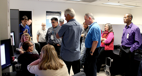
AOL researchers recently led development of the Integrated Demand Management concept for operational integration of two of the FAA’s NextGen decision support systems to improve capacity-constrained arrival operations in the National Airspace System (NAS). The AOL’s HITL simulation platform was used to engage stakeholders in the development and evaluation of new methods and procedures for using Traffic Flow Management System (TFMS) initiatives to strategically precondition traffic for the more tactical Time-Based Flow Management (TBFM) system (FAA TBFM overview video). This preconditioning was shown in a series of realistic HITLs to improve the efficiency and predictability of TBFM operations and provide airline operators more control over individual flight outcomes when weather- or traffic-related congestion affected operations.
Air Traffic Controllers taking part in an Integrated Demand Management (IDM) research simulation in the Airspace Operations Laboratory (AOL) at NASA Ames Research Center.
Credit – NASA
Why IDM?
FMS and TBFM represent two powerful NextGen automation systems used to address demand/capacity imbalances in the NAS. Recent enhancements to TBFM that extend its geographic and temporal range have introduced some overlap with TFMS functionality, raising the question of which system to use in some situations. TFMS features such as its collaborative decision making framework and new Collaborative Trajectory Options Program (CTOP) (FAA CTOP overview video) and Trajectory Option Set (TOS) capabilities, however, are absent from TBFM. Integrated Demand Management (IDM) proposes that often the best solution can be found by leveraging the complementary features of both systems, developing coordinated strategic (TFMS) + tactical (TBFM) flow management interventions as needed.
IDM Concept
IDM uses a strategic Traffic Management Initiative (TMI), such as CTOP, to adjust the rate and/or geographic distribution across arrival flows of the traffic inbound to a high-demand, TBFM-managed airport. This TFMS intervention preconditions the traffic before it reaches the TBFM planning horizon. This results in a more workable problem for TBFM, which can then tactically fine-tune the demand to deliver a well-managed, orderly feed to the destination airport. Coordinated use of these two flow management capabilities is intended to improve system performance in terms of:
Equity of ground delay assignment, avoiding excessive ground delay for TBFM-scheduled departures, without penalizing longer flights;
Throughput, by distributing traffic to maximize use of available capacity;
Predictability for operators, providing advance notice about the impact on individual flights;
Increased flexibility, by supporting operator mitigation strategies such as slot swapping and trajectory options;
Efficiency of flight operations, by improving access to user-preferred routes, using ground delay more effectively, and reducing airborne delay.
Traffic Flow Management System (TFMS) Deployment Team and representatives from MITRE Corp and MIT Lincoln Labs participate in IDM demonstration in the AOL
Credit – NASA
Research Products
The AOL’s IDM research was a stakeholder-centered, laboratory-based development process that provided the following products to the FAA.
An IDM Concept and Procedures document and IDM Concept Overview slides that describe its context of use and the operational procedures for planning, coordination and execution of IDM operations in today’s NAS.
A description of CTOP User Interface Enhancements that were developed in the course of IDM HITL evaluations and demonstrations. While some of these were designed to support IDM-specific tasks, most were improvements that stakeholders found valuable for CTOP in general.
A description of the IDM Flow Balancing Algorithm (FBA). The FBA was an algorithm that traffic managers could use to support design of an IDM CTOP that improved the distribution of inbound traffic across multiple arrival flows.
An IDM Annotated Bibliography that provided an overview of the research publications conducted or supported by NASA under IDM, including links to all of the NASA-produced publications.
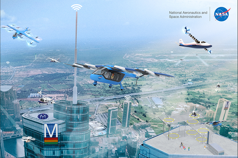
The High Density Vertiplex (HDV) subproject is responsible for the development and evaluation of a reference automation architecture that addresses scalable and efficient aircraft operations, flight and airspace management procedures, and vertiport operations in high density vertiplex environments.
HDV is a sub-project of the Advanced Air Mobility (AAM) project under the Integrated Aviation Systems Program (IASP).
What is a Vertiplex?
A Vertiplex is a geographic area that includes multiple vertiports whose arrival and departure operations are highly interdependent.
Artists conception of High Density Vertiplex (HDV) operations in an urban environment.
Credit – NASA
Purpose and Research Approach
The purpose of this research is to design concepts, procedures, and technologies focused on Urban Air Mobility (UAM) operations in a vertiplex environment. The HDV approach will be to gradually build-up complexity in the operational environment through a series of tests. Testing will be performed subscale using small Unmanned Aerial Systems (sUAS) as surrogates for UAM aircraft. Testing cycles will start out fully simulated, then culminate in live flight tests with small UAS at Langley Research Center. Results from each testing cycle will be used to support subsequent risk assessments. The overall goal is to create a representative UAM system to mitigate risk for future research and development.
Concepts Being Explored
Aircraft-airspace-vertiport automation technology must be integrated and matured to support three main use cases: (1) automated landing, (2) automated merging and spacing, and (3) automated contingency decision making.
NASA researchers participating in a High Density Vertiplex (HDV) study in the Airspace Operations Laboratory (AOL).
Credit – NASA
Role of the AOL in HDV
During simulations and flights tests, the Airspace Operations Laboratory (AOL) and the Autonomous Vehicle Applications Laboratory (AVAL) will serve as the base of operations for Airspace Systems Integration (ASI), which integrates systems and software from Unmanned Aerial Systems (UAS) Traffic Management (UTM) to support HDV concepts. Some of the outcomes of this work include prototype airspace management automation technology and human factors evaluation. Joining the AOL in the HDV flight testing efforts are the Autonomous Vehicle Applications Laboratory (AVAL) from the NASA Ames’ Human Systems Integration Division, and the Air Traffic Operations Laboratory (ATOL) from Langley Research Center.
The Exoplanet Technology group in the Astrophysics Division at NASA Ames is dedicated to advancing direct imaging technologies, including the ultimate goal of imaging Earth-like exoplanets and searching them for signs of life.
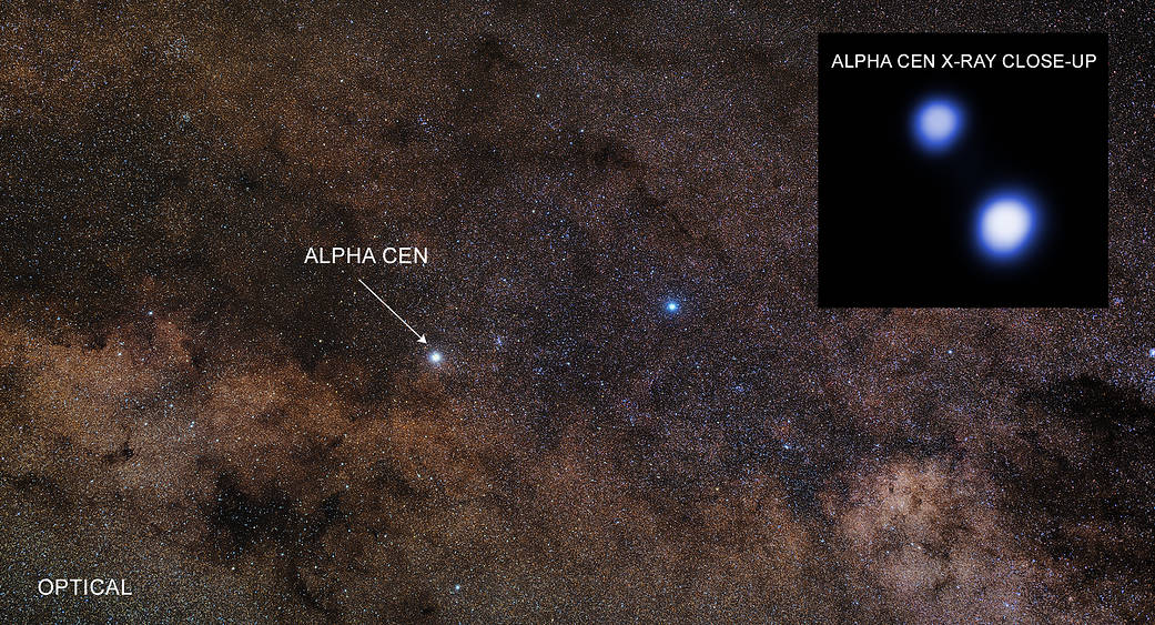
Technology enabling exoplanet imaging in binary stars systems.
NASA Ames leads and supports the hardware working group for the Roman Coronagraph Participation Program, which enables international teams to develop capabilities beyond the instrument’s baseline modes
State of the art test beds, vacuum chambers, and labs.
These facilities enable researchers to validate new instruments, algorithms, and wavefront-control techniques before they are deployed on space missions.
A deeper characterization of exoplanets and their host stars.
Combining theoretical research and observations to support NASA missions and enhance their scientific return. Developing models and analysis techniques to interpret observations from missions such as Kepler, TESS, Hubble, and Webb.
Developing innovative small mission concepts, such as ACESat, to demonstrate new technologies and explore compelling exoplanet science opportunities. These concepts help mature mission architectures and technologies while providing a pathway to address high-priority science goals with cost-effective, focused missions.
In conjunction with NASA Langley Research Center, NASA’s Airspace Operations Lab explored issues and ideas for allocating separation assurance functions to meet the future air transportation needs. A separation assurance system primarily performs the functions necessary to ensure that aircraft remain safely separated from other traffic. Such a system is also simultaneously concerned with the avoidance of severe weather, the conformance of flights to a variety of operational constraints, and the overall expeditious flow of traffic from origin to destination.
In the current system, air traffic services provide these functions. However even with the current level of operations, this can result in excessive controller workload, limited capacity and, often, inefficient operations. With an expected increase in traffic, these weaknesses can be exacerbated. New automation in the air, on the ground and/or the cloud, and powerful new communication technologies have enabled different ways to allocate trajectory management and separation assurance functions.
NASA’s functional allocation research successfully identified the strengths and weakness of different allocations of separation assurance functions amongst the wide variety of agents participating in the air traffic operation. This research helped provide a roadmap to ensure that fundamental research is pointed towards an efficient final state. The future system has helped handle growing travel in a safe, efficient, and sustainable manner.
The Republic of Djibouti will sign the Artemis Accords during a ceremony at 11 a.m. EDT, Monday, Sept. 14, at NASA Headquarters in Washington, becoming the 72nd country signatory.
NASA Deputy Administrator Matt Anderson will host Ambassador of Djibouti to the United States Mohamed Siad Douale for the ceremony, together with U.S. State Department Assistant Secretary for African Affairs Frank Garcia.
In 2020, during the first Trump Administration, the United States, led by NASA and the State Department, joined with seven other founding nations to establish the Artemis Accords, responding to the growing interest in lunar activities by both governments and private companies.
The accords introduced the first set of practical principles aimed at enhancing the safety, transparency, and coordination of civil space exploration on the Moon, Mars, and beyond.
President Donald Trump presents an executive order establishing the United States Space Academy during an event to award the Congressional Space Medal of Honor to the Artemis II crew as Michael Kratsios, director of the Office of Science and Technology Policy, left; Kevin Hassett, director of the National Economic Council, third from left; and NASA Administrator Jared Isaacman, right, applaud, Friday, Aug. 28, 2026, at NASA’s Johnson Space Center in Houston.
Credit: NASA/John Kraus
Less than two weeks after an Executive Order was signed to create the first United States Space Academy, NASA-led work is in full swing to make the academy a reality and shape the future of America’s aerospace workforce and leadership.
NASA Administrator Jared Isaacman chaired the first Presidential Commission on the United States Space Academy meeting on Sept. 9. Following that meeting, NASA published a Request for Information Thursday seeking input from governors or their designees interested in hosting and sponsoring the up-and-coming academy in their state.
“Our first Commission meeting made clear how much talent and commitment we have behind President Trump’s vision for the U.S. Space Academy,” said NASA Administrator Jared Isaacman. “I’m grateful to our partners across government for getting right to work. Now, with the RFI underway, states across the country have an opportunity to help us shape a legacy institution built for America’s future in space.”
Isaacman and Deputy Administrator Matt Anderson welcomed key commission members from multiple agencies and organizations to NASA Headquarters in Washington for a collaborative Commission discussion. Participants included U.S. Secretary of War Pete Hegseth, Director of the National Economic Council Kevin Hassett, Secretary of the United States Air Force Troy Meink, and U.S. Chief Technology Officer Ethan Klein, representing Director of Office and Technology Policy Michael Kratsios, along with representatives from the U.S. Office of Management and Budget, the National Security Council, and the White House.
During the meeting, commission members began working through the structure and priorities of the proposed U.S. Space Academy, including its governance, curriculum, service commitments, partnerships, and implementation.
“The location of the U.S. Space Academy is foundational to its success,” said Anderson. “We’re asking states to bring their strongest vision — the infrastructure, the partnerships, and the community that can compete with the elite options this caliber of student will have and match the boundless ambition of our future space leaders.”
The commission’s 120-day mandate to develop recommendations for President Trump on how to establish the academy and build the technical talent and leadership pipeline needed to support America’s long-term goals in space began when the President signed the Executive Order on Aug. 28.
Responses to the RFI will help inform the commission’s path forward to selecting a location for the institution and are due by 6 p.m. EDT on Monday, Oct. 26. An ambitious timeline is outlined in the request, calling for a groundbreaking no later than 2027, temporarily hosting the first 300 students in 2028, and a permanent location in operation by 2031.
Each state is allowed one submission to the Announcement via its governor’s designee. In addition to details about resources available to support the academy, input sought on the potential campus includes:
Location information
Site readiness
Environmental and regulatory considerations
Proximity and supporting ecosystems
A fact sheet on the U.S. Space Academy is available on The White House website.
NASA’s Life-Saving Technology Where Cell Signals Can’t Go
Rescued after more than four hours in the water, Easton Barrett (center, red shorts) and his friend were picked up by the U.S. Coast Guard thanks to a personal locator beacon (PLB). The devise sends a distress signal to satellites that are relayed back to Earth, launching a rescue operation.
Credits: Easton Barrett
Memorial Day weekend 2024 started with a blue sky and a mild three- to four-foot chop in the water off the Gulf Coast of Mississippi — a perfect day for a fishing competition. A team of five was about 40 miles offshore checking their sonar, and 30 seconds later the boat was gone. They were in the water struggling to pull on life jackets and grab the coolers as they bobbed up. When a boat sinks, survivors can be virtually invisible amid the vast expanse of water.
When their fishing trip went wrong, Easton Barrett had the only mobile phone and no cell service. He recorded a brief farewell, planning to put his phone in a cooler in hopes someone would find it.
Another team member activated a personal locator beacon (PLB) that had been stowed at the last minute, which sent a distress signal to the Search and Rescue Satellite-Aided Tracking (SARSAT) technology carried by multiple satellites in Earth orbit. In the SARSAT system, developed partly by NASA, an emergency signal containing the transmitter’s location is directed to the nearest available ground station.
406 megahertz is the wavelength dedicated for PLB distress signals. On the annual 406 Day, Easton Barrett posts videos and messages on his social media accounts to help raise awareness about essential survival gear.
Credit: ACR
A mission control center then alerts rescue coordination centers to mobilize search and rescue crews. For Barrett and his crew, that was a Florida Coast Guard boat.
“Ever since, I have tried to teach others about safety on the water and in the outdoors by using a PLB,” said Barrett. “If that will save one life, it’s worth the effort.”
A beacon like the one that saved his crew, a registered ResQLink PLB developed by ACR Electronics Inc. of Fort Lauderdale, Florida, also notifies the device owner’s emergency contact, indicating a distress call was activated. All emergency beacons must meet the same requirements to ensure they work when needed. Every rugged, buoyant, handheld devices have a five- to 10-year battery life.
SARSAT began operations in 1982, becoming an international collaboration in 1985. The flight and ground technologies used globally were originally developed at NASA’s Goddard Space Flight Center in Greenbelt, Maryland. Now there are 62 satellites in the program and 45 nations contributing services, from operating ground stations to providing rescue crews. More than 63,000 lives have been saved.
Turning on a ResQLink View PLB from ACR Electronics will automatically “ping” orbiting satellites that send location and GPS information
to the nearest search and rescue station. Whether on land or water, the appropriate resources will be dispatched to help anyone in distress
anywhere in the world.
Credit: ACR
SARSAT by the Numbers
The Search and Rescue Satellite-Aided Tracking system developed over several decades by NASA and other government agencies saves lives on land or at sea.
1982 — the start of U.S. operations
1985 — the start of international operations
62 operational satellites
45 nations contributing services
63,000+ lives saved
One rescue in 2024 demonstrates how it all comes together.
40 miles off the Mississippi Gulf Coast
5-person team participating in a fishing competition
30 seconds for a boat to sink
200 pounds of bait dumped to make a cooler buoyant
3 close encounters with wildlife, likely sharks and eels
4 hours in the water
1 personal locator beacon
1 Coast Guard rescue boat
5 lives saved
“If it has anything to do with NASA, it’s got to be awesome.”

 Login