❌

Normal view

Super Typhoon Bavi

9 July 2026 at 05:01
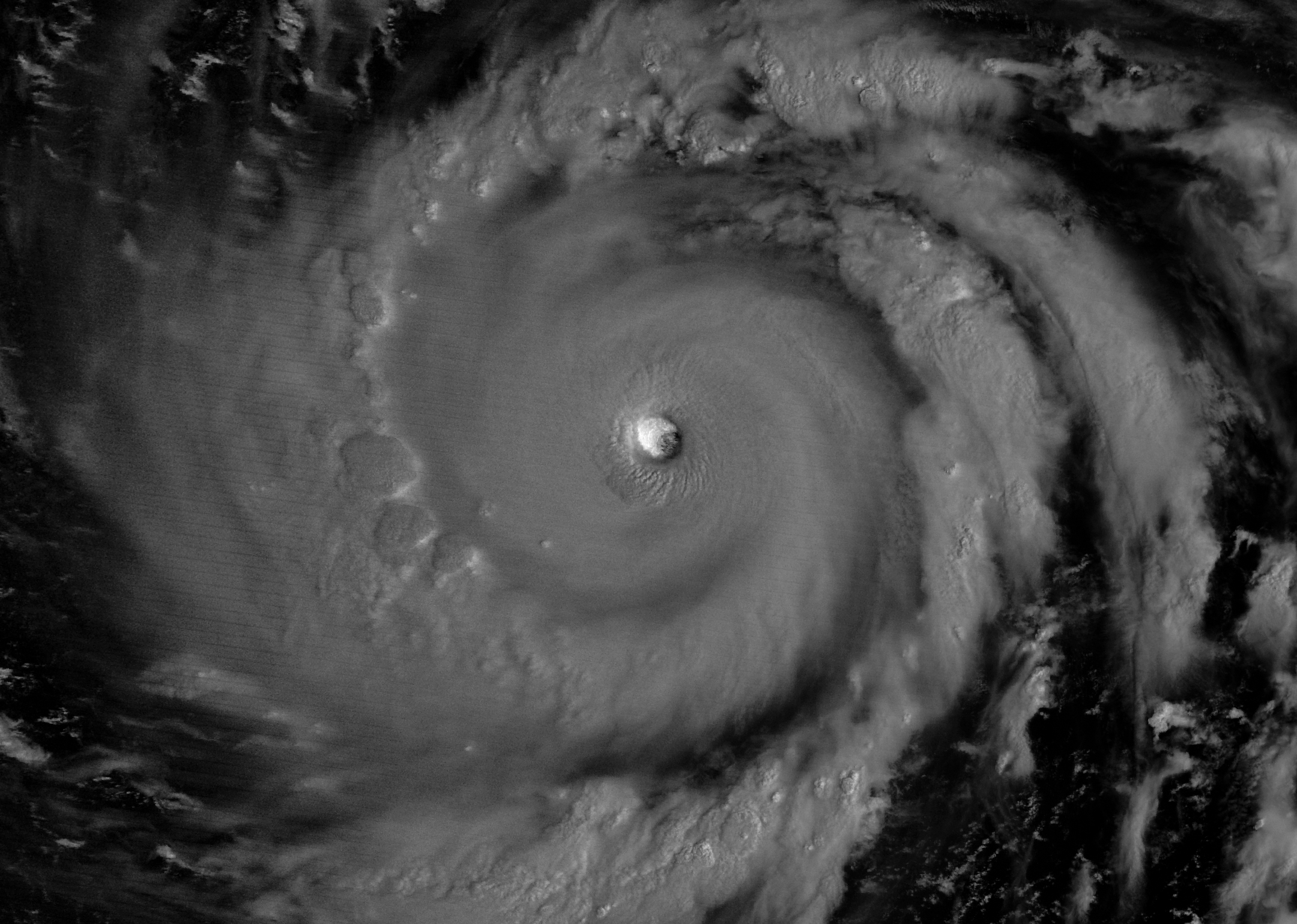
The eyewall of a super typhoon is partially illuminated by moonlight in a nighttime satellite image.
Moonlight illuminates the western side of Super Typhoon Bavi’s eyewall at about 15:30 Universal Time on July 5 (1:30 a.m. local time on July 6). The image was acquired with the VIIRS (Visible Infrared Imaging Radiometer Suite) day-night band on the NOAA-20 satellite.
NASA Earth Observatory/Michala Garrison

In early July 2026, for the second time in three months, a powerful typhoon crossed the U.S. Northern Mariana Islands and Guam in the North Pacific Ocean. Super Typhoon Bavi was at peak intensity when it neared the islands on the night of July 5, bringing winds of 290 kilometers (180 miles) per hour, along with torrential rain and dangerous storm surge.

This nighttime image, captured by the VIIRS (Visible Infrared Imaging Radiometer Suite) on the NOAA-20 satellite, shows Bavi’s eye at about 15:30 Universal Time on July 5 (1:30 a.m. local time on July 6). Light from the Moon, which was in the waning gibbous phase, illuminates the eyewall’s western side. The eye passed over Rota, north of Guam, several hours after the image was acquired.

Bavi became a super typhoon in the early hours of July 4 local time while tracking west over the warm ocean. Satellite observations indicated that sea surface temperatures were around 30 degrees Celsius (86 degrees Fahrenheit) in the region. Bavi was the third tropical cyclone in 2026 to reach category 5 intensity on the Saffir-Simpson wind scale.

The typhoon caused extensive damage across Guam, Rota, and Saipan, according to news reports, downing power poles and lines; flooding roads and littering them with debris; and damaging buildings, including a water distribution station on Rota. U.S. Coast Guard crews worked to clear navigation hazards in the waterways around Guam and the Northern Marianas and reopen ports as dangerous marine conditions subsided, according to reports. This damage comes on top of destructive winds and flooding from Super Typhoon Sinlaku, which crossed the islands in mid-April.
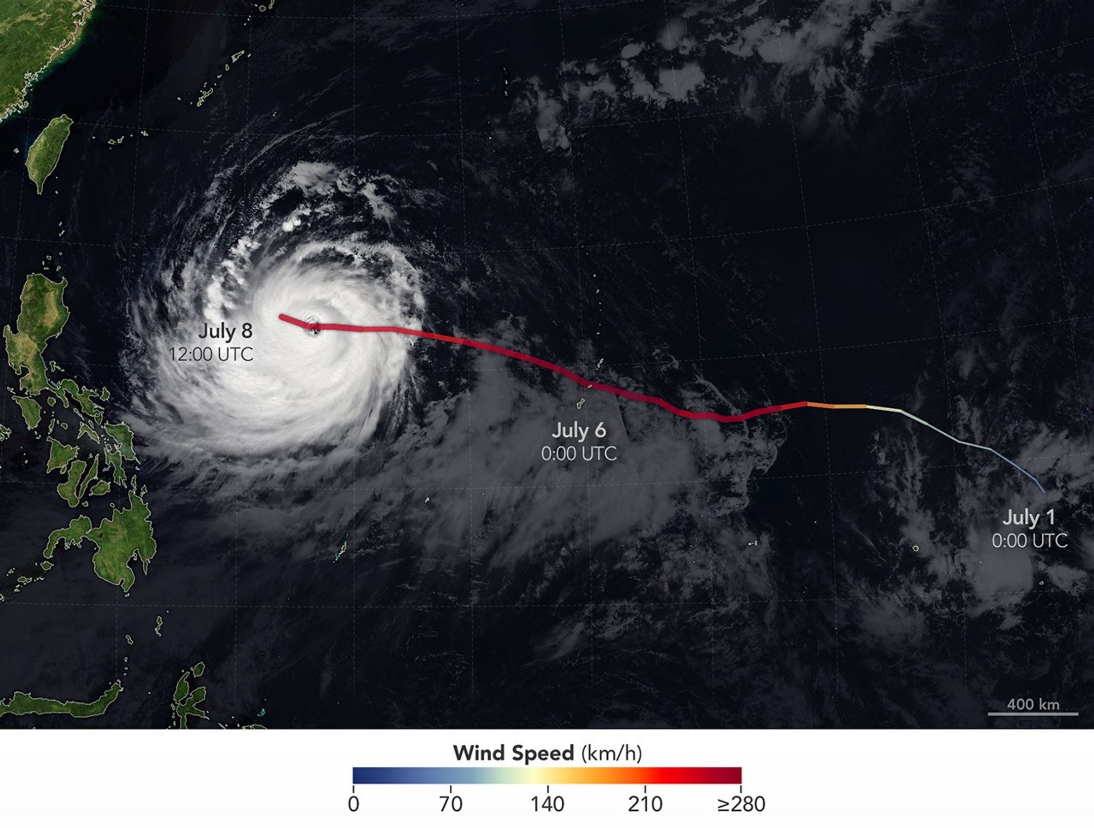
The spiraling clouds of Super Typhoon Bavi appear over the Philippine Sea southeast of Taiwan. The storm’s westward track is shown in colors corresponding to wind speed.
Super Typhoon Bavi tracked west over the Northern Mariana Islands toward Asia in early July 2026. The storm’s clouds and path are overlaid on a Blue Marble: Next Generation image built from scenes captured by the MODIS (Moderate Resolution Imaging Spectroradiometer). The image of the storm was captured by the VIIRS (Visible Infrared Imaging Radiometer Suite) on the NOAA-21 satellite on July 8, 2026, at about 04:30 Universal Time.
NASA Earth Observatory/Michala Garrison

On July 8, Bavi remained a powerful typhoon as it moved west over the Philippine Sea. In the early afternoon, when the image above was captured, the National Weather Service reported maximum sustained wind speeds of 250 kilometers (155 miles) per hour. Forecasts indicated the typhoon’s track could bend northwest toward Taiwan, the Ryukyu Islands of southern Japan, and mainland China and weaken over the next several days.

Writing in Yale Climate Connections, meteorologist Jeff Masters said that Bavi is the type of storm that might be expected when a strong El Niño event is building, which is currently the case. El Niño-year typhoons may form farther east, giving them more time over warm water to intensify before curving toward Asia, Masters explained, “resulting in a greater chance of reaching Category 5 intensity.”

NASA Earth Observatory images by Michala Garrison, using data from NASA EOSDIS LANCE, GIBS/Worldview, and the Joint Polar Satellite System (JPSS), and hurricane track data from the U.S. Naval Research Laboratory. Story by Lindsey Doermann.

Downloads

The eyewall of a super typhoon is partially illuminated by moonlight in a nighttime satellite image.

July 5, 2026

JPEG (1.47 MB)

The spiraling clouds of Super Typhoon Bavi appear over the Philippine Sea southeast of Taiwan. The storm’s westward track is shown in colors corresponding to wind speed.

July 8, 2026

JPEG (1.54 MB)

References & Resources

You may also be interested in:

Stay up-to-date with the latest content from NASA as we explore the universe and discover more about our home planet.

Super Typhoon Sinlaku

3 min read

The violent storm aimed at the U.S. Northern Mariana Islands and Guam in mid-April 2026.

Article

Typhoon Jangmi

2 min read

The sprawling storm promised to deliver torrential rain across a wide swath of southern Japan.

Article

Gravity Waves From Super Typhoon Sinlaku

4 min read

Satellites observed striking upper-atmosphere phenomena generated by an intensifying tropical cyclone.

Article

Students Connect NASA Science With Indigenous Knowledge to Study Coastal Erosion

8 July 2026 at 22:04

3 min read

Students Connect NASA Science With Indigenous Knowledge to Study Coastal Erosion

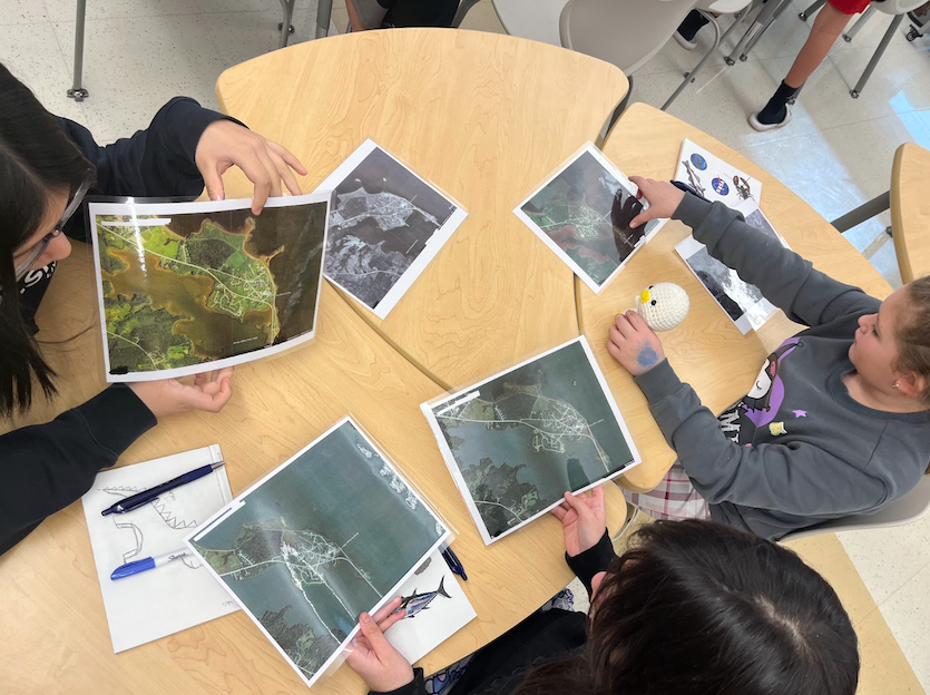
Three students sitting around a classroom table looking at NASA satellite images.
Students return from fieldwork and sit together in the classroom, examining NASA satellite images to learn about the changes to their community’s coastline.

Story by Keri Moskowitz, Gulf of Maine Research Institute

For the Pleasant Point Passamaquoddy Reservation, or Sipayik, the ocean has always been a teacher. Situated in what is known as Downeast Maine, along the shores of Passamaquoddy Bay, generations of Indigenous people have lived along the coast, learning from the tides, the land, and their elders. But today, the shoreline is changing more rapidly. Coastal erosion is slowly taking land away. Land that already holds a history of loss.

In the summer of 2023, inspired by a trip to Fairbanks, AK to attend Climate Change in My Community  – a workshop organized by the NASA Science Activation (SciAct) program’s Arctic and Earth Signs project – SciAct’s Learning Ecosystems Northeast (LENE) team began working with partners, including Indigenous leaders and scientists, to ask an important question: What does coastal erosion mean to people who have already lost land?

By November 2024, planning was underway at Sipayik Elementary School. The goal was to bring together Western science and Indigenous knowledge so students could understand the changes happening in their own community.

The lessons began in March 2025. For five weeks, nine 5th-grade students explored erosion in many ways. They visited local field sites and listened to elders share stories about how the coastline used to look. Learners used these accounts to measure the changes, both on the coast and via maps back in the classroom. They built erosion trays from simple materials to test how waves shape the land. They measured current high tide lines and compared them to historical ones. They studied old photographs and aerial images from 1942 to 2023 to see how much the shoreline had moved. They even compared 300-year-old tribal maps with future flood projections.

Students learned that science does not only live in textbooks. As one observer shared, “Our people were scientists without having to go to school.”

The students were curious, engaged, and proud. They saw that resilience is part of who they are. They have always adapted while holding on to culture. 

In June of 2026, the students were invited to the Gulf of Maine Research Institute to present their work to scientists, staff, and REU (Research Experience for Undergraduate) interns. They traveled 3.5 hours for this opportunity, and the journey proved worthwhile. During the Q&A portion following their slideshow, someone asked whether learning to read the various maps was difficult. One student responded with a reminder: these were not merely maps but NASA satellite images.

Future goals for the project include inviting more elders and adding more field sites in the work, strengthening language and cultural connections, sharing student learning with other Native youth, and planning resilience strategies like marsh restoration in coordination with tribal leadership. When the students were asked if they planned to continue their studies and work on this cause after their time in the classroom ended, they all resoundingly stated “YES”.

In Sipayik, the story of erosion is not just about land washing away. It is about memory, knowledge, identity, and the strength of a community that continues to learn from the shore.

Share

Details

Last Updated
Jul 08, 2026
Editor
NASA Science Editorial Team

Related Terms

Hubble Captures Star-Studded Cluster

8 July 2026 at 15:13
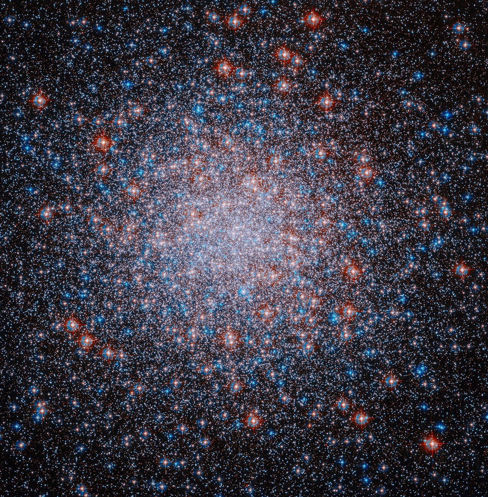
A packed, roughly spherical cluster of red, white and blue stars shines against the black background of space. The stars are clustered most densely toward the center of the cluster.
This image from NASA’s Hubble Space Telescope shows Messier 3, a densely packed cluster of stars whose origins may be a merger between globular clusters in the early universe.
NASA, ESA, and A. Sarajedini (Florida Atlantic University); Processing: Gladys Kober (NASA/Catholic University of America)

This image from NASA’s Hubble Space Telescope showcases Messier 3 (M3), one of the Milky Way galaxy’s most massive globular clusters, or spherical collections of gravitationally bound stars. Globular clusters are made up of ancient stars that formed at roughly the same time from the same cloud of gas, giving those stars similar ages. Around 150 known globular clusters are sprinkled around the outer regions of the Milky Way.

Learn more about M3.

Image credit: NASA, ESA, and A. Sarajedini (Florida Atlantic University); Processing: Gladys Kober (NASA/Catholic University of America)

Cottonwood Fire Chars Utah

8 July 2026 at 05:01


June 5
June 29

Mountainous landscapes appear green and untouched by fire in a satellite image acquired on June 5, 2026.
NASA Earth Observatory/Michala Garrison

An image of the same area shows a large brown patch spanning much of the image in an image acquired after the fire on June 29, 2026.
NASA Earth Observatory/Michala Garrison

Mountainous landscapes appear green and untouched by fire in a satellite image acquired on June 5, 2026.
NASA Earth Observatory/Michala Garrison
An image of the same area shows a large brown patch spanning much of the image in an image acquired after the fire on June 29, 2026.
NASA Earth Observatory/Michala Garrison

June 5

June 29


A burned landscape spans more than 150 square miles (390 square kilometers) of rugged terrain northwest of Junction, Utah, as seen in this pair of images captured by the OLI (Operational Land Imager) on Landsat 8 and Landsat 9 on June 5, 2026 (left) and June 29, 2026 (right). NASA Earth Observatory images by Michala Garrison.

After a winter of below-average snowpack and an unusually warm and dry start to summer, the National Interagency Fire Center warned that the Great Basin and parts of the Rockies faced an elevated risk of wildfires in July 2026.

The warning proved accurate. By July 7, firefighters labored to contain nearly three dozen large, early-season wildland fires that raced through forests in several parts of the western U.S. Utah was among the most active states, with fires having charred 558 square miles (1,445 square kilometers) and four major fires that were not fully contained still burning.

The Cottonwood fire ranked as one of Utah’s—and the country’s—largest and most destructive fires of the year so far. As of July 7, it had burned 150 square miles (390 square kilometers), just shy of the Babylon fire in eastern Utah. Landsat 9 captured the false-color image (bands 7-5-4) above (right) on June 29, 2026, when blackened vegetation spanned a large patch of rugged terrain along the Beaver River. The image on the left shows the same area on June 5, a few weeks before the fire ignited. In this band combination of shortwave infrared, near infrared, and visible light, unburned vegetation appears bright green, snow is blue, and clouds are white.

Ponderosa pine, oak, sagebrush, and grasses were among the vegetation types that burned. Officials with the state’s forestry division told news media that the Cottonwood fire had destroyed up to 150 structures. Eagle Point Ski Resort, which lost more than 100 condos and 30 cabins, also reported damage to four of its five chairlifts.

The damage to forests was extensive, though isolated patches survived largely unscathed, remaining as green oases within the broader burned area. Among them were the forests around Tushar Campground, the site of a 4-H summer camp. Beaver County officials credited years of forest treatments, such as clearing brush and trimming branches, with helping save the campground and surrounding forests.

The fire spreads especially rapidly on June 23 and June 26. The fire perimeters in this visualization are based on data from NASA’s Fire Events Data Suite.
NASA Earth Observatory/Michala Garrison

As the fire spread, NASA’s Fire Events Data Suite (FEDS) tracked its progression and rate of growth. The visualization above, based on the FEDS system, shows the fire surging on June 23 and tripling in size over 12 hours that day as it spread to the north, east, and south. It also grew rapidly on June 26, when it made a run to the north. FEDS draws on data from the VIIRS (Visible Infrared Imaging Radiometer Suite) sensors aboard the Suomi NPP, NOAA-20, and NOAA-21 satellites, which detect active fires day and night by their thermal infrared signature.

FEDS is one of several tools available to firefighters and emergency management officials when responding to fires. First responders often rely on higher-resolution airborne imagers or on firefighters walking fire edges to map perimeters. FEDS offers a different advantage: consistent, easily accessible data that do not need to be specially requested, according to Tempest McCabe, a University of Maryland scientist based at NASA’s Goddard Space Flight Center who helped develop the tool. As a result, FEDS often detects a fire’s start earlier than other sources and tracks blazes for their full duration. To capitalize on strengths like these, the FEDS team is working closely with operational fire behavior analysts, with support from NASA’s FireSense program, to better understand and anticipate periods of rapid fire spread.

A total of 1,289 firefighters have been deployed to the Cottonwood fire, according to InciWeb, a website managed by the National Interagency Fire Center. As of July 7, the fire was 56 percent contained, but forecasters expect a hot, dry weather pattern to persist in the coming days, with fire behavior likely to be “very active to extreme” over the next 72 hours.

Government satellite data are part of a global system of observations used to track fire behavior and analyze emerging trends. Among the real-time wildfire monitoring tools that NASA makes available are FIRMS (Fire Information for Resource Management System), the Worldview browser, and the Fire Event Explorer.

As of July 7, 2026, fires had burned 5,265 square miles (13,636 square kilometers) across the United States, according to the National Interagency Fire Center. That’s 46 percent more than the 10-year average (2016-2025) for that point in the season.

NASA Earth Observatory images by Michala Garrison, using Landsat data from the U.S. Geological Survey and fire perimeter data from the Fire Events Data Suite. Story by Adam Voiland.

Downloads

Mountainous landscapes appear green and untouched by fire in a satellite image acquired on June 5, 2026.

June 5, 2026

JPEG (1.39 MB)

An image of the same area shows a large brown patch spanning much of the image in an image acquired after the fire on June 29, 2026.

June 29, 2026

JPEG (1.41 MB)

An animation shows the expansion of the fire between June 23 and July 7, with the burned area from the fire beginning as a small patch near Beaver, Utah, and then spreading north, east, and south.

FEDS fire perimeter (June 23-July 7)

JPEG (1.80 MB)

References & Resources

You may also be interested in:

Stay up-to-date with the latest content from NASA as we explore the universe and discover more about our home planet.

Fires Tear Through Nebraska Grasslands

3 min read

Dry, warm, and windy conditions across the U.S. Great Plains led to extreme fire activity in March 2026.

Article

Fire’s Footprint on Santa Rosa Island

3 min read

A wildland fire charred grassland, coastal sage scrub, and chaparral across one-third of the island, the second largest of the…

Article

Smoke Rises Over Big Cypress National Preserve

2 min read

The National fire has burned tens of thousands of acres within the Florida preserve, fueled by vegetation dried by prolonged…

Article

NASA Transfers ‘Hundred Acre Wood’ to Patuxent Research Refuge

7 July 2026 at 19:00
2 Min Read

NASA Transfers ‘Hundred Acre Wood’ to Patuxent Research Refuge

a small crowd holds up a triangular pennant flag with "250" on it, with a field and trees in the background
Following a ceremony on July 7, 2026, officials hold up a U.S. 250th pennant at “Area 400,” a 105-acre parcel previously part of NASA’s Goddard Space Flight Center in Greenbelt, Md., and now part of the U.S. Fish and Wildlife Service’s Patuxent Research Refuge.

NASA ceremonially transferred ownership of about 105 acres of wooded land at its Goddard Space Flight Center’s Greenbelt, Maryland, campus Tuesday to the adjoining Patuxent Research Refuge, managed by the U.S. Fish and Wildlife Service.

The property, formerly known as NASA Goddard’s Area 400, is now part of the largest block of unfragmented forest between Washington and Baltimore. The nearly 13,000-acre woodland is the nation’s only refuge specifically established to support wildlife research. The refuge also supports recreational uses, such as walking, biking, horseback riding, fishing, and hunting.

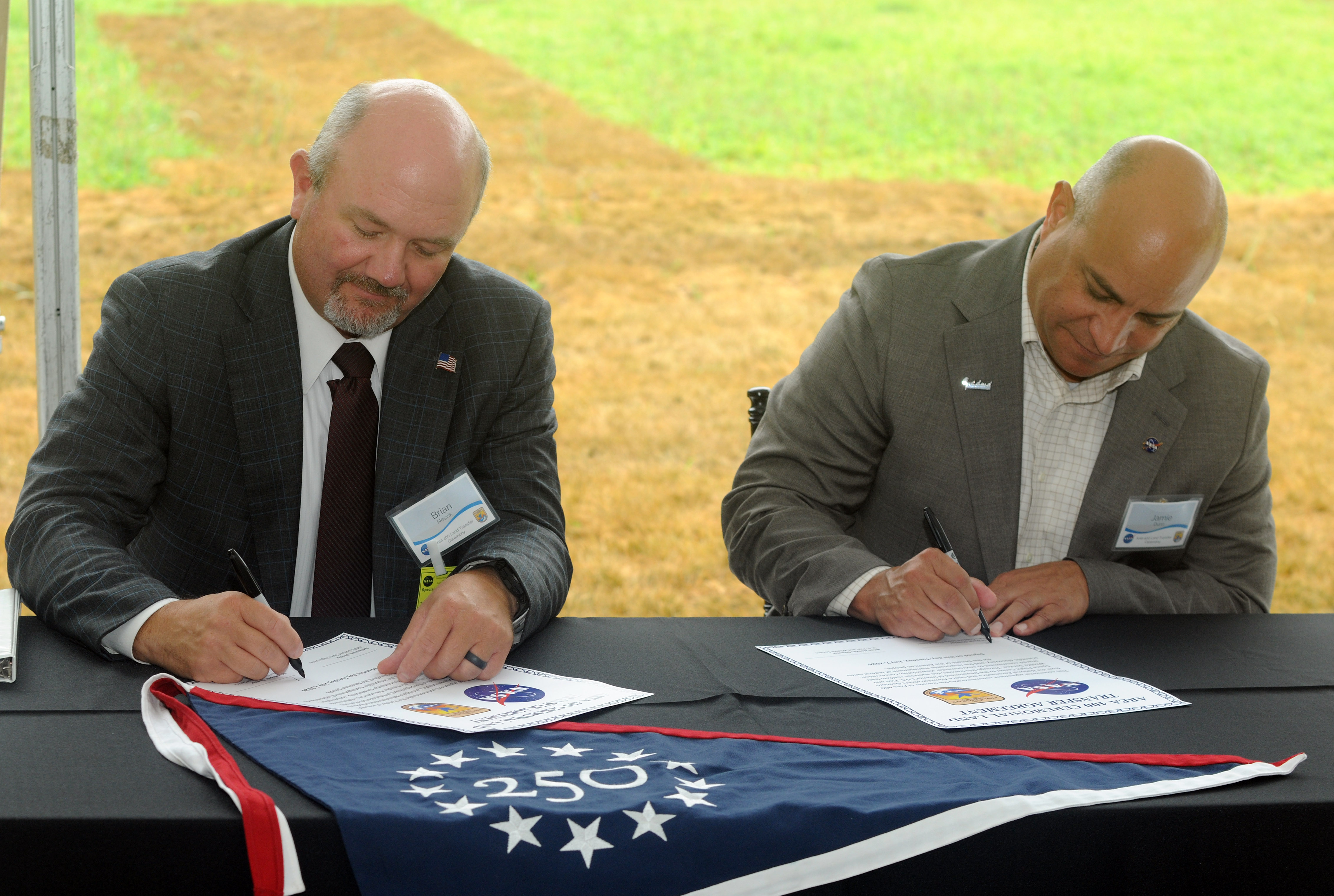
two men sign certificates on a table with black tablecloth
At a ceremony on July 7, 2026, U.S. Fish and Wildlife Service Director Brian Nesvik (left) and Jamie Dunn, center director, NASA’s Goddard Space Flight Center, Greenbelt, Md., sign certificates that ceremonially transfer a 105-acre parcel of property known as “Area 400” from NASA Goddard to the Service.
NASA

“For over six decades, NASA Goddard has helped shape humanity’s understanding of Earth,” said Jamie Dunn, center director, NASA Goddard. “We’re glad to present this land to our colleagues in the Fish and Wildlife Service, whose conservation and research helps do the real legwork in preserving our Blue Marble for future generations.”

NASA Goddard had used Area 400 for propellant research beginning in the 1960s. That work has largely since shifted to NASA facilities in other states or to commercial providers, and the property had long been a candidate for divestment. NASA and the Service began discussing a potential transfer in 2021.

a Monarch butterfly rests on a man's hand
Following remarks from attending dignitaries and the signing ceremony, assembled guests participated in a monarch butterfly release and milkweed seed dispersal.
NASA

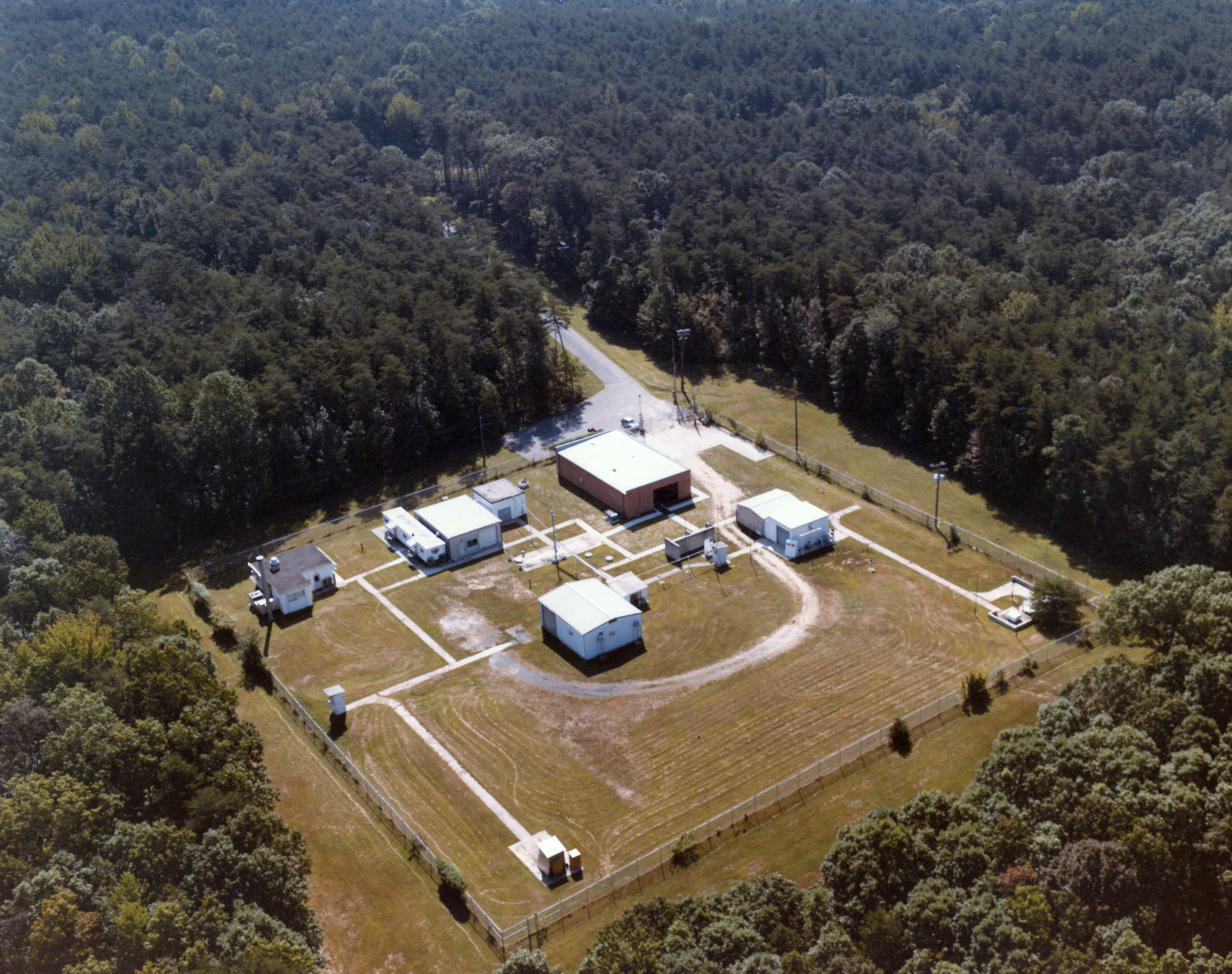
Prior to the transfer, Area 400 was still almost entirely wooded aside from a two-and-a-half-acre clearing with 11 small structures. The interagency transfer was effective on Feb. 23, and NASA recently completed its final closeout activities at the property, deconstructing the buildings, roadway, and utility service.

This aerial photograph shows Area 400’s appearance in 1984. The surrounding forest has remained largely unchanged since NASA Goddard occupied the property in the 1960s.
NASA

“Through working with partners on the best use of land, as exemplified with this land transfer, we can continue to conserve America’s natural beauty and expand outdoor recreation opportunities for future generations,” said U.S. Fish and Wildlife Service Director Brian Nesvik.

Media contacts:

Rob Garner
News Chief, Office of Communications
NASA’s Goddard Space Flight Center

Keith Shannon
Regional Communications Lead – U.S. Fish and Wildlife Service Northeast Region
U.S. Department of the Interior

NASA’s New Horizons Spacecraft Wakes from Hibernation in Good Health

7 July 2026 at 18:48

3 min read

NASA’s New Horizons Spacecraft Wakes from Hibernation in Good Health

Following its longest hibernation period ever of nearly a year, NASA’s New Horizons spacecraft has emerged in good health and is ready to begin transmitting science data gathered in the distant Kuiper Belt far beyond Pluto.

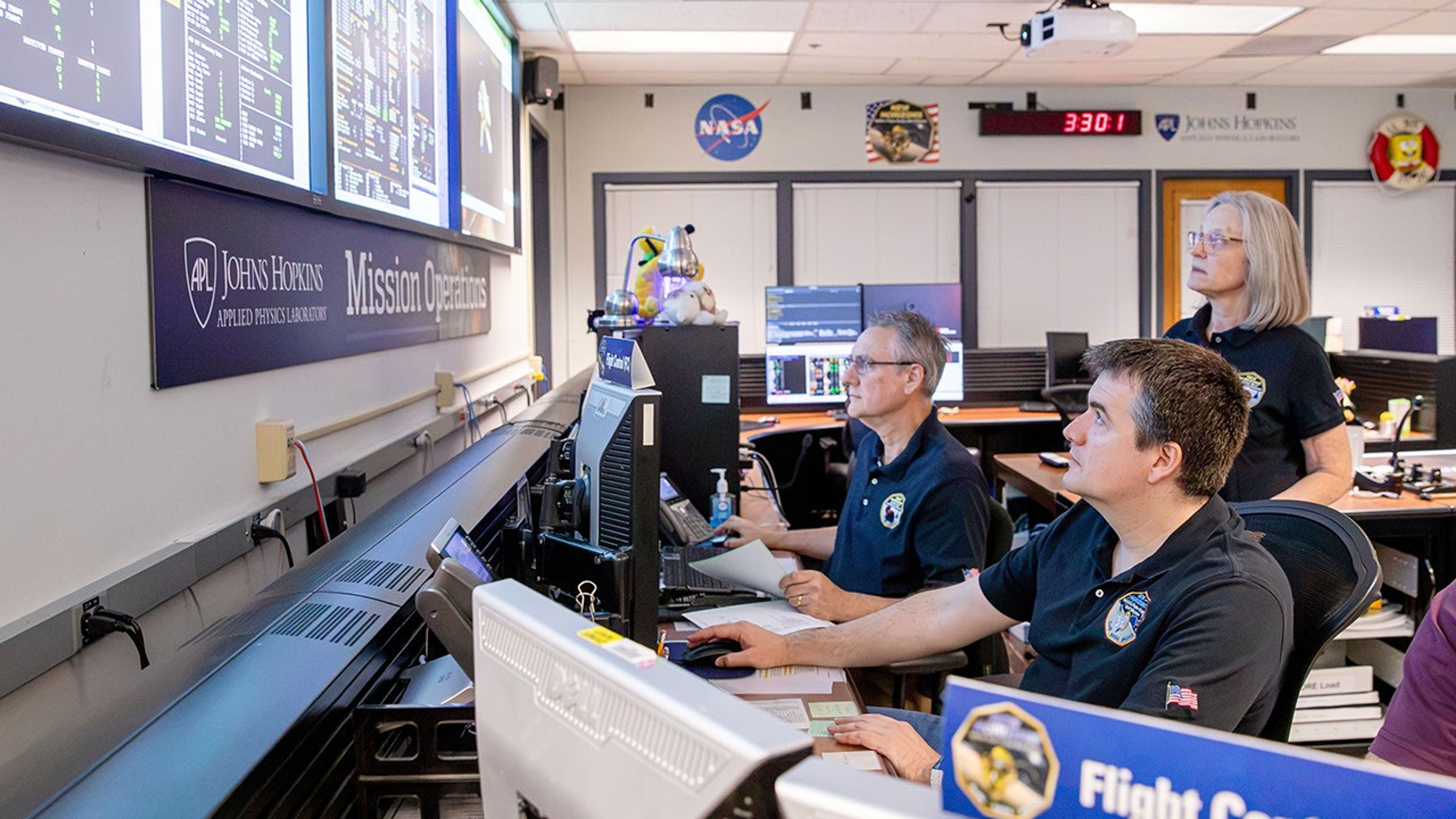
Flight operators at computers in a mission control center monitor spacecraft data on large wall displays.
From left, flight controllers Mark Lahr and Josh Albers, and Mission Operations Manager Alice Bowman, monitor telemetry streaming from NASA’s New Horizons spacecraft to the mission operations center at the Johns Hopkins Applied Physics Laboratory in Laurel, Maryland, on June 24, 2026. Now approximately 5.9 billion miles (9.5 billion kilometers) from Earth, New Horizons is ready to begin transmitting science data after being awakened from its longest ever, nearly yearlong hibernation period.
NASA/Johns Hopkins APL/SwRI/Justin Gladden

On June 23, flight controllers at the Johns Hopkins Applied Physics Laboratory (APL) in Laurel, Maryland, confirmed New Horizons, acting on stored commands uplinked to its main computer last July, had safely awakened from a 321‑day hibernation period that began Aug. 7. With the spacecraft now approximately 5.9 billion miles (9.5 billion kilometers) from Earth, the radio signals carrying that confirmation took about 8 hours and 52 minutes to reach the APL Mission Operations Center via NASA’s Deep Space Network station near Madrid, Spain.

The mission team typically places New Horizons in resource‑saving hibernation mode during long cruise periods. While the spacecraft is hibernating, operators do not send commands or retrieve data, but the spacecraft continues gathering and storing data around the clock from its heliospheric plasma sensors, Solar Wind at Pluto and the Pluto Energetic Particle Spectrometer Science Investigation, as well as its space dust detector, the Venetia Burney Student Dust Counter.

Alice Bowman, the New Horizons mission operations manager at APL, said the spacecraft reported back to Earth, via the Deep Space Network, with a weekly status beacon. “Every status report through this hibernation period was ‘green,’ meaning all was well aboard New Horizons each and every week,” she said.

As New Horizons resumes active operations, Bowman noted, the team will begin downlinking spacecraft health and safety data, followed by data from the three scientific instruments. In about three weeks, the spacecraft’s onboard Alice ultraviolet spectrograph will look at the hydrogen gas distribution in the outer heliosphere, while the Solar Wind at Pluto, the Pluto Energetic Particle Spectrometer Science Investigation, and the Venetia Burney Student Dust Counter instruments continue their measurements, and the ground team conducts a series of spacecraft and instrument checkouts.

The team also is completing upgrades to the ground‑system software that will make it easier to maintain operations of the spacecraft. Tests are already underway and are expected to continue through the year.

New Horizons is operating on updated autonomy logic designed for operations farther from the Sun and to accommodate the expected reduction in power and the naturally occurring increase in radio‑signal travel time.

The NASA spacecraft’s exploration of this distant region of the solar system marks the latest step in a journey that began in January 2006 with the fastest launch on record; a flyby of Jupiter in February 2007 that included stunning views of the gas giant and its moons; the first exploration through the Pluto system in July 2015; the first exploration of a Kuiper Belt object, Arrokoth, in January 2019, and unique studies of the Sun’s outer heliosphere and dozens of additional Kuiper Belt objects since then.

For more information on NASA’s New Horizons mission, visit:

https://science.nasa.gov/mission/new-horizons/

Artemis II Crew and Apollo 14 Moon Tree

7 July 2026 at 17:16
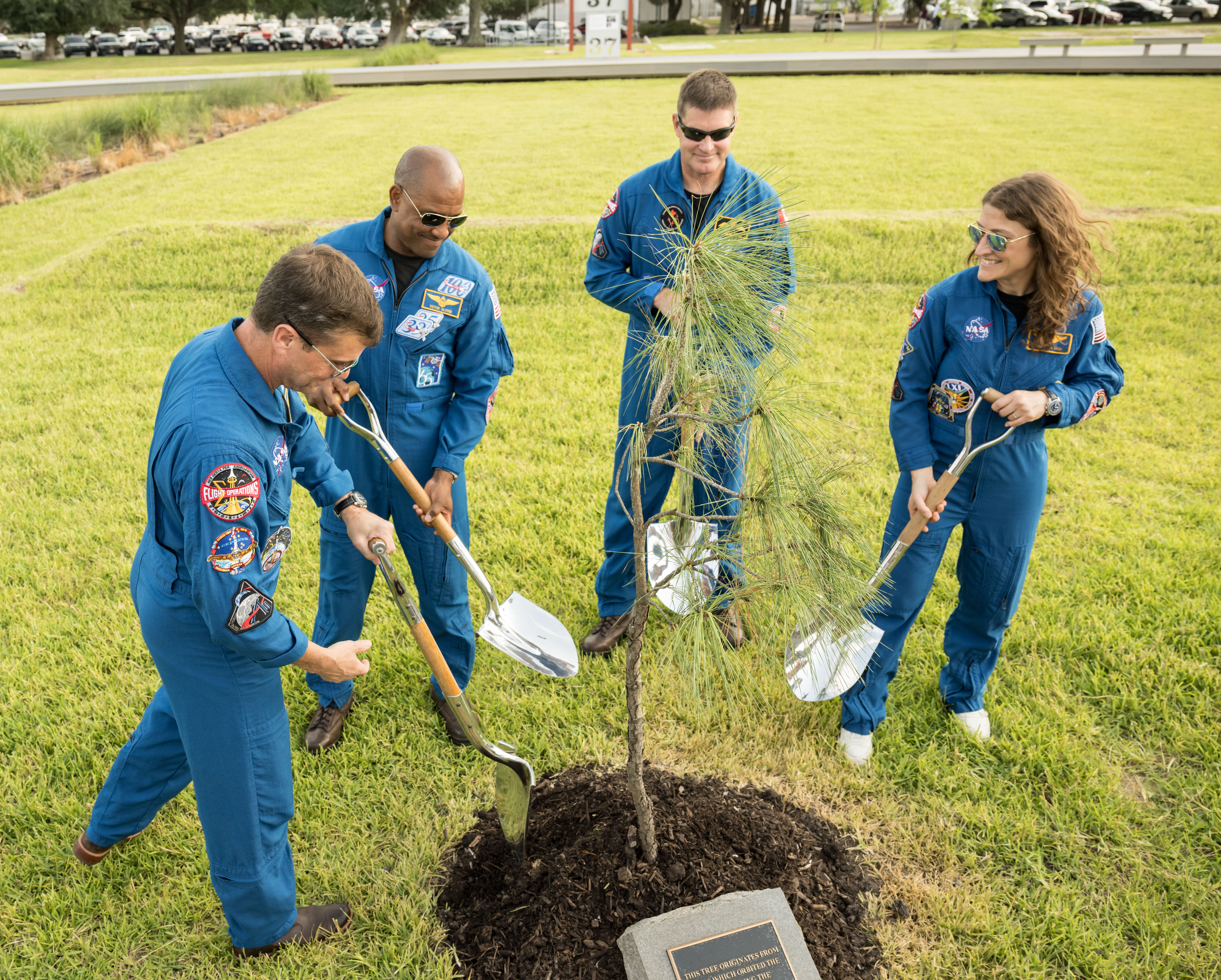
The members of the Artemis II mission hold shovels as they stand around a young pine tree. From left to right, they are Reid Wiseman, Victor Glover, Jeremy Hansen, and Christina Koch. They are all looking down at the tree, which is surrounded by mulch. There is a plaque at the front of the mound of dirt. The grass the crew are standing on extends behind them for several yards.
NASA/James Blair

In this photograph, the Artemis II crew participates in the dedication of the Apollo 14 Moon tree at the Lunar Receiving Park at NASA’s Johnson Space Center on June 25, 2026. This tree is a second-generation Apollo Moon tree of the loblolly pine species. The original Apollo Moon trees were grown from seeds carried aboard Apollo 14 by NASA astronaut Stuart Roosa, a former U.S. Forest Service smoke jumper. Upon return to Earth, the seeds were germinated by the Forest Service, and the resulting seedlings were planted throughout the United States and around the world.

Image credit: NASA/James Blair

July 2026 Satellite Puzzler

7 July 2026 at 16:48
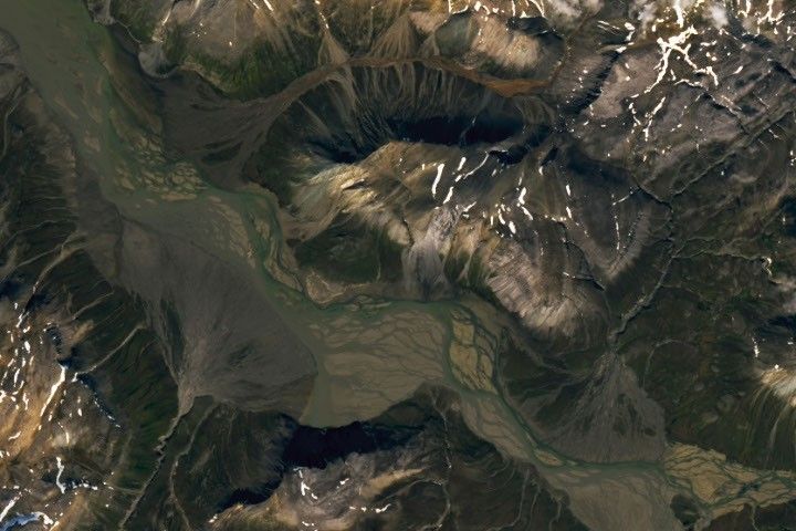
A braided river meanders across the image. Smaller streams empty into the wide channel from either side, forming fan-shaped deposits.

Every month, NASA Earth Observatory features a puzzling satellite image. The July 2026 puzzler appears above. 

Your Challenge
I
dentify the location shown in this satellite image. Share what clues you see, where you think it is, and what makes this place interesting or unique to you.

How to Answer
Submit your response using this form and select “Puzzler Answer” as the topic. Please include your preferred name or alias.

You can keep it simple and just guess the location. Want to impress us? Tell us which satellite and instrument captured the image, which spectral bands were used, or point out a subtle detail about the geology or history of the area. If something catches your eye, or if this is your home or means something to you, we’d love to hear about it.

The Prize
We can’t offer prize money or a trip to space to see Earth like satellites and astronauts do. But we can offer something almost as rewarding: puzzler bragging rights.

About a week after the challenge, we’ll post the answer at the top of this page, along with a link to an Earth Observatory Image of the Day story that explains the image in more detail. We’ll recognize the first person who correctly guesses the location, and we may also highlight readers who share especially thoughtful or interesting answers. By submitting a response, you acknowledge that your comments may be edited, excerpted, and published on this page.

Until then, zoom in, look closely, and enjoy the challenge. See you at the reveal!

The World Cup From 250 Miles Up

7 July 2026 at 05:00
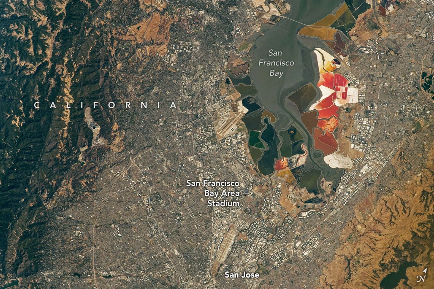
An aerial view of the San Francisco Bay Area Stadium, middle-left, is surrounded by urban infrastructure. Colorful ponds of the southern San Francisco Bay are visible toward the top.
July 26, 2022

In summer 2026, sixteen stadiums across North America hosted matches as part of the FIFA World Cup. Over the years, astronauts aboard the International Space Station have captured a top-down view of the infrastructure, landscapes, and ecosystems surrounding many of these venues.  

Six of the matches were played at the San Francisco Bay Area Stadium, beginning on June 13 with a match-up between Qatar and Switzerland. This stadium (also called Levi’s Stadium) is located in Santa Clara, California, adjacent to San Jose and around 40 miles (64 kilometers) south of San Francisco. An astronaut aboard the International Space Station took this photo (above) on July 26, 2022.

The stadium, completed in 2014, is surrounded by a mix of recreational, housing, and business infrastructure. The scene includes the southern part of San Francisco Bay, which is 23 years into a 50-year effort to restore up to 90 percent of the region’s salt ponds to tidal wetlands and marshlands, while retaining some of its salt-making heritage.

The Bay Area hosted its sixth and final World Cup match on July 1, when the U.S. faced off against Bosnia and Herzegovina in a knockout match. The U.S. advanced to the round of 16 following a 2-0 win.

An aerial view of the San Francisco Bay Area Stadium, middle-left, is surrounded by urban infrastructure. Colorful ponds of the southern San Francisco Bay are visible toward the top.
April 17, 2022

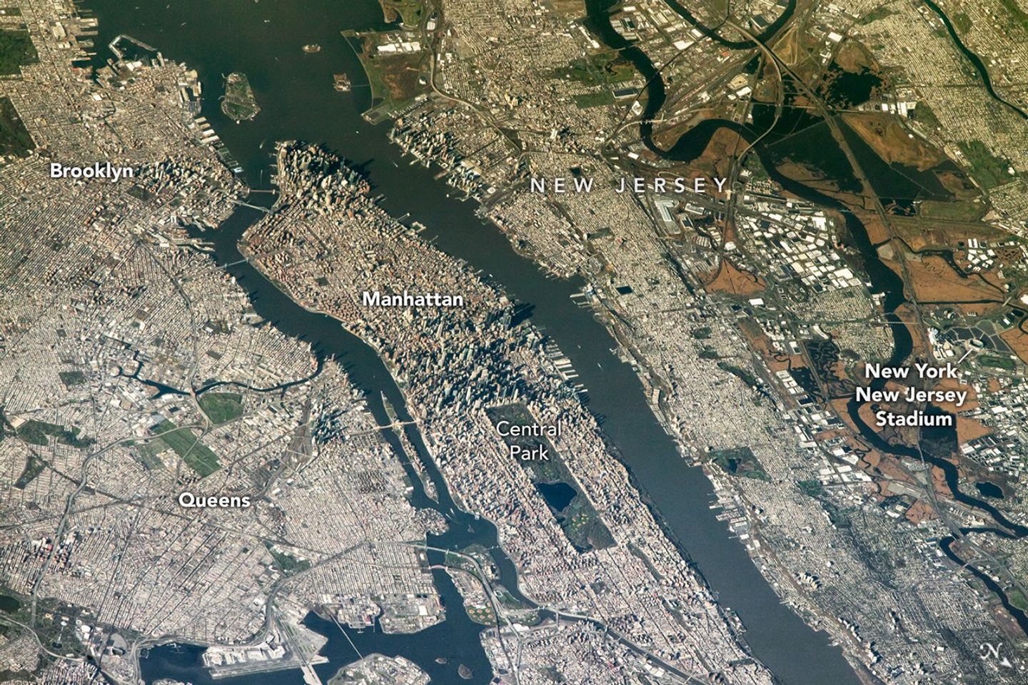
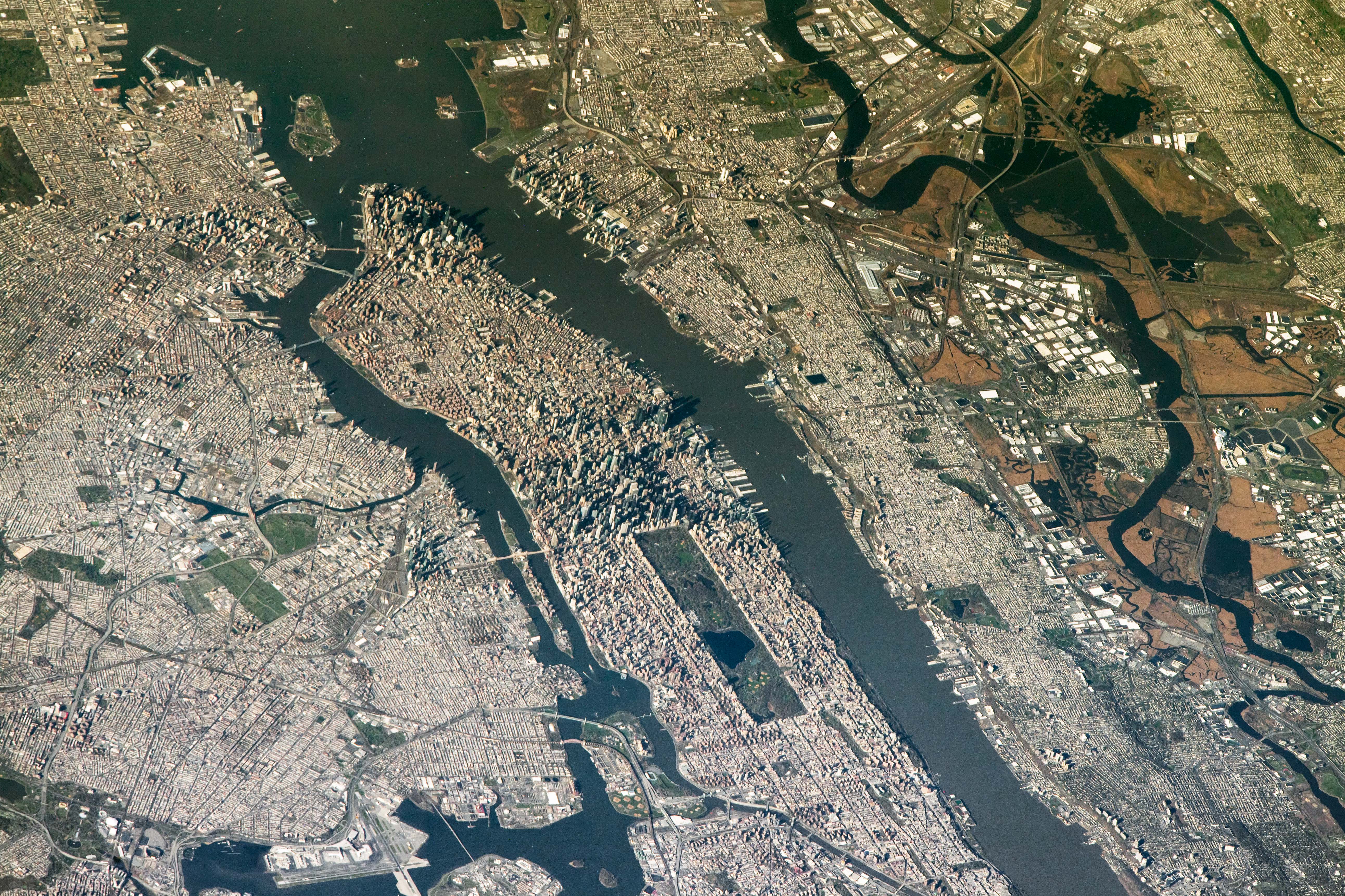
The FIFA World Cup final is scheduled for July 19 at New York New Jersey Stadium, part of the Meadowlands Sports Complex, in East Rutherford, New Jersey. The stadium (also called MetLife Stadium) sits along the New Jersey Turnpike, west of Midtown Manhattan. Note that north is toward the bottom-right of this photo, captured by an astronaut on April 17, 2022.

The area has seen centuries of human impact. Colonists cleared wetlands and cedar forest for settlements, and development for a range of economic and industrial uses followed. In the 20th century, it became an unregulated dumping ground. In recent decades, though, wetland restoration efforts have occurred alongside the development of the sports and entertainment complex.

Other World Cup host cities have also appeared in astronaut photography and satellite imagery. Guadalajara Stadium (Estadio Akron), Los Angeles Stadium (SoFi Stadium), Houston Stadium (NRG Stadium/Reliant Stadium), and BC Place Vancouver (BC Place) are among the venues that have been observed from above.

Astronaut photograph ISS067-E-202213 was acquired on July 26, 2022, with a Nikon D5 digital camera using a focal length of 400 millimeters, and astronaut photograph ISS067-E-18580 was acquired on April 17, 2022, with a Nikon D5 digital camera using a focal length of 1150 millimeters. They are provided by the ISS Crew Earth Observations Facility and the Earth Science and Remote Sensing Unit at NASA Johnson Space Center. The images were taken by a member of the Expedition 67 crew. The images have been cropped and enhanced to improve contrast, and lens artifacts have been removed. The International Space Station Program supports the laboratory as part of the ISS National Lab to help astronauts take pictures of Earth that will be of the greatest value to scientists and the public, and to make those images freely available on the Internet. Additional images taken by astronauts and cosmonauts can be viewed at the NASA/JSC Gateway to Astronaut Photography of Earth. Story by Kathryn Hansen.

Downloads

An aerial view of the San Francisco Bay Area Stadium, middle-left, is surrounded by urban infrastructure. Colorful ponds of the southern San Francisco Bay are visible toward the top.

July 26, 2022

JPEG (17.97 MB)

An aerial view shows the New York New Jersey Stadium and surrounding Meadowlands on the right, with the dense urban landscape of Manhattan Island centered in the frame.

April 17, 2022

JPEG (3.18 MB)

References & Resources

You may also be interested in:

Stay up-to-date with the latest content from NASA as we explore the universe and discover more about our home planet.

Great Balls of Fire

4 min read

An astronaut on the International Space Station was surprised to photograph a shower of light streaking through the darkness while…

Article

San Francisco’s Metropolitan Mosaic

3 min read

Urban development, green spaces, and maritime activity converge in this Northern California city.

Article

A Moonlit Earth as Seen From Artemis II

4 min read

An astronaut’s photo, taken en route to the Moon, reveals our planet and its place in space in a novel…

Article

NASA Takes Flight For America’s 250th

6 July 2026 at 19:38
NASA/Keegan Barber

NASA Administrator Jared Isaacman leads a flyover featuring his personally owned Northrop F-5 Tiger during the Great American State Fair on July 4, 2026, on the National Mall in Washington, D.C.

For 250 years, America has pushed the boundaries of what’s possible. From the earliest days of exploration, to the first steps on the Moon and the missions shaping our future, NASA represents the spirit of discovery that defines our nation.

As the United States celebrates its semiquincentennial, Freedom 250 highlights how innovation, courage, and scientific leadership have carried America forward — and how NASA continues to expand the frontier for the next generation.

❌