Sometime next week, NASA's newest rover on Mars, Perseverance, will set a record for the most distance driven by any vehicle on another world.
The automobile-sized rover, which landed on Mars in February 2021, will traverse beyond 45.16 km (28.06 miles) across the Martian surface. In doing so it will break the previous distance record held by the long-lived Opportunity rover, which ceased communications with NASA in 2018.
So how did Perseverance reach this record-setting distance in just a third of the time?
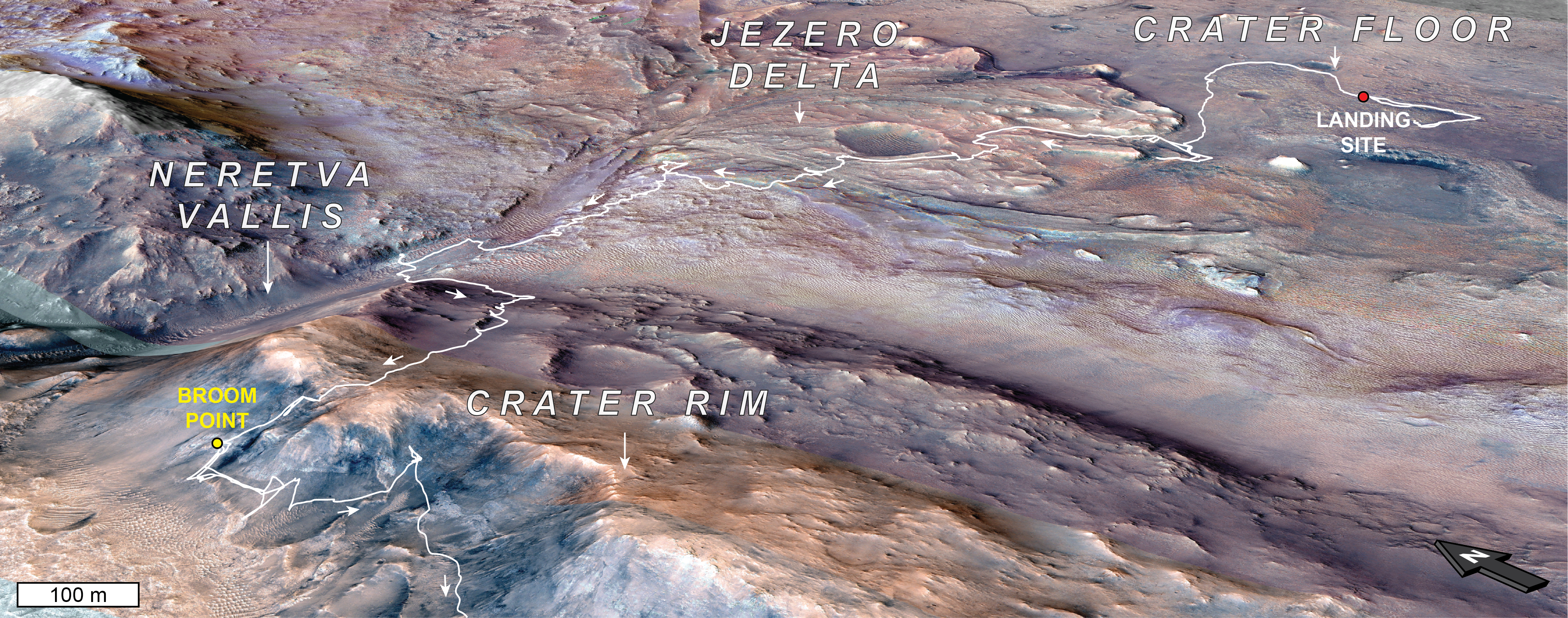
This orbital map shows the path NASA’s Perseverance Mars rover took to get to a location the science team has dubbed the “Broom Point member,” a sequence of layered bedrock likely more than 3.9 billion years old. As planned, the rover landed inside Jezero Crater on Feb. 18, 2021. It investigated the crater’s western delta and inlet river valley, Neretva Vallis, before summiting the crater rim in December 2024 following a rim-to-crest climb of 2,620 feet (800 meters).
The Broom Point region is situated on the outer edge of the crater rim and was visited by the rover in mid-2025. The yellow dot indicates location where the rover took a selfie.
NASA’s Jet Propulsion Laboratory, which is managed for the agency by Caltech in Pasadena, California, built and manages operations of the Perseverance rover. Arizona State University leads the operations of the Mastcam-Z instrument, working in collaboration with Malin Space Science Systems in San Diego, on the design, fabrication, testing, and operation of the cameras, and in collaboration with the Niels Bohr Institute of the University of Copenhagen on the design, fabrication, and testing of the calibration targets.
JPL manages the Mars Reconnaissance Orbiter for NASA’s Science Mission Directorate in Washington as part of NASA’s Mars Exploration Program portfolio. Lockheed Martin Space in Denver built MRO and supports its operations. The University of Arizona, in Tucson, operates HiRISE, which was built by Ball Aerospace & Technologies Corp., in Boulder, Colorado.
That visitor—a robotic rover named Perseverance—has been conducting investigations on Mars since February 18, 2021, and the new aerial images reveal its current location in an area that mission specialists have dubbed “Arbot.”
While Perseverance’s latest appearance reveals little more than a greenish spec on the planet’s rust-colored surface, also visible in the new images are the long path its formidable tires have left in the Martian soil as the robotic explorer has trekked west of its initial landing site.
The new images, captured on June 13, 2026, were taken just one day before Perseverance broke the previous distance record held by a robotic explorer on Mars: NASA’s Opportunity rover.
However, Perseverance completed this phase of its journey in record time compared to its predecessor, which took more than 11 years to traverse a similar distance. Perseverance, by contrast, covered the same distance in less than half that time, with just five years and four months of travel now behind it.
In the image above, NASA’s Perseverance Rover appears in the center of the image as a small, greyish-green reflective spot. Also visible are the impressions left by its all-terrain tires, revealing the robotic rover’s long path over the last several years of Martian exploration (Image Credit: Credits: NASA/JPL-Caltech/University of Arizona)
The images were made possible by the MROs’ High-Resolution Imaging Science Experiment (HiRISE) camera, which also captured surface features in the Arbot area that include ridges and windswept areas along Mars’ rugged exterior.
Built and operated by the University of Arizona, HiRISE captures images with resolutions as fine as about 25 centimeters (10 inches) per pixel, allowing researchers to distinguish features roughly the size of a kitchen table from orbit. The camera has returned hundreds of thousands of detailed images since the MRO arrived at Mars two decades ago, contributing to a growing data set that has transformed scientists’ understanding of the Red Planet.
Documenting everything from active dust avalanches and shifting dunes to fresh impact craters, the unprecedented resolution its imagery provides has made HiRISE one of the most powerful planetary imaging instruments ever deployed.
Last year, the MRO’s HiRISE camera also successfully captured images of the interstellar comet 3I/ATLAS as it made its way past Mars during its trip through our Solar System. Although the HiRISE images weren’t the clearest images of the interstellar visitor obtained during its visit, they did help demonstrate just how formidable NASA’s MRO and its suite of instruments are.
Micah Hanks is the Editor-in-Chief and Co-Founder of The Debrief. A longtime reporter on science, defense, and technology with a focus on space and astronomy, he can be reached atmicah@thedebrief.org. Follow him on X @MicahHanks, and at micahhanks.com.

 Login