❌

Reading view

Expedition 74 Works Scientific Installs, Suit Prep Ahead of Canadarm2 Repair Spacewalk

The aurora australis crowns Earth’s atmosphere in this photograph taken at approximately 3:13 a.m. local time from the International Space Station as it orbited 269 miles above the Indian Ocean east of the French Southern and Antarctic Lands. In the foreground, the Canadarm2 robotic arm extends from a power and data grapple fixture attached to the Harmony module.
The aurora australis crowns Earth’s atmosphere above the Indian Ocean as the Canadarm2 robotic arm extends from a power and data grapple fixture attached to the Harmony module.
NASA/Chris Williams

Scientific hardware installations and biomedical monitoring topped the research schedule aboard the International Space Station on Wednesday. The Expedition 74 crew members also adjusted a spacesuit to prepare for a spacewalk and explored space physics to round out their day.

A series of shoebox-sized CubeSats will soon be deployed outside the Kibo laboratory module into Earth orbit for public and private research. One of the satellites, Hokushin-1 CubeSat, will test space technologies such as radio frequency, propulsion, and solar arrays. NASA flight engineer Jack Hathaway finished installing a small satellite orbital deployer, packed with the CubeSats, into Kibo’s airlock where it will soon be placed in the vacuum of space and grappled by the Japanese robotic arm. The deployer will be maneuvered with the robotic arm and positioned away from the orbital outpost to safely release the tiny satellites into Earth orbit.

Onboard the orbital outpost are a variety of research freezers—large, small, portable, and permanent—that house and preserve station research samples for analysis both on Earth and in space. One of them, a smaller glovebox freezer, is being installed inside Kibo’s Life Science Glovebox (LSG) by NASA flight engineer Jessica Meir for upcoming experiment operations. The freezer’s location inside the LSG allows the samples to be stowed and frozen immediately after processing to prevent degradation and preserve integrity during sensitive biology research.

Meir also assisted flight engineer Sophie Adenot of ESA (European Space Agency) as she set up wearable devices for a pair of biomedical tests on Wednesday. Adenot first measured her blood pressure to calibrate the PhysioTool technology demonstration gear. Next, she wore head and body sensors that measured her brain oxygen and blood flow levels as she performed cognitive and mental tasks on a computer. Researchers are testing the portable device onboard the station to potentially monitor crew health on missions to the Moon, Mars, and beyond.

Meir also had time to help NASA flight engineer Chris Williams pack cargo inside a SpaceX Dragon cargo spacecraft that will undock from the Harmony module’s forward port and soon return to Earth. Williams then maneuvered into the Quest airlock and adjusted a spacesuit’s legs, arms, and helmet, then ensured the suit’s switches and valves were correctly configured ahead of an upcoming spacewalk.

On May 27, during routine operations of the International Space Station’s Canadarm2, the system demonstrated an elevated motor current in a wrist joint and arm motion did not occur as expected. NASA worked alongside CSA (Canadian Space Agency) to understand the issue and determined a spacewalk will be required to replace the joint using a spare already aboard the orbital complex. The Canadarm2, which is designed to be repaired in orbit, is in a safe configuration and standard operations using the arm have been paused. In the coming weeks, NASA will host a news conference to discuss the repair and preview the planned Tuesday, June 30 spacewalk. NASA will share more on the spacewalkers closer to the activity.

Roscosmos cosmonauts Sergey Kud-Sverchkov and Sergei Mikaev joined each other and explored space physics in the Zvezda service module. The duo observed how two different sized spheres drift freely in microgravity with no pushing movement from the crew. Results may lead to the design of newer space tools, improved robotics, and a deeper understanding of crew motion. Roscosmos flight engineer Andreu Fedyaev focused primarily on maintenance testing computer operations, cleaning ventilation systems, and transferring water between station tanks.

Finally, the space station is orbiting higher today after the Progress 95 cargo spacecraft fired its thrusters for over eight minutes early Wednesday raising its altitude by 1.9 miles. This adjusts the orbital outpost’s altitude ahead of the launch and docking of the Soyuz MS-29 crew spacecraft planned for mid-July.

Learn more about station activities by following the space station blog, @space_stationon X, as well as the ISS Facebook and ISS Instagram accounts.

Get the latest from NASA delivered every week. Subscribe here.

The post Expedition 74 Works Scientific Installs, Suit Prep Ahead of Canadarm2 Repair Spacewalk appeared first on NASA Science.

  •  

Tyndall’s Trail of Bergs

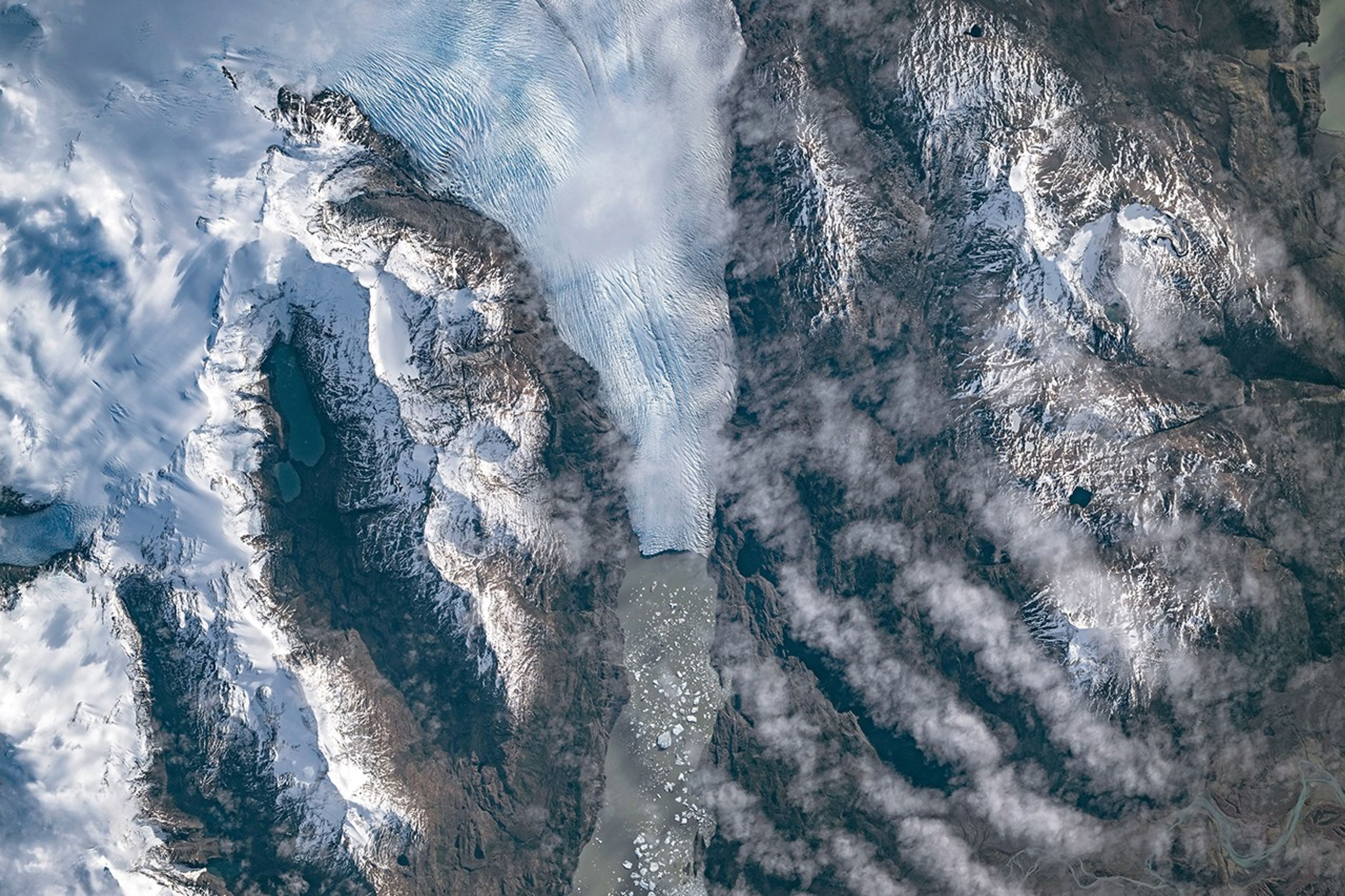
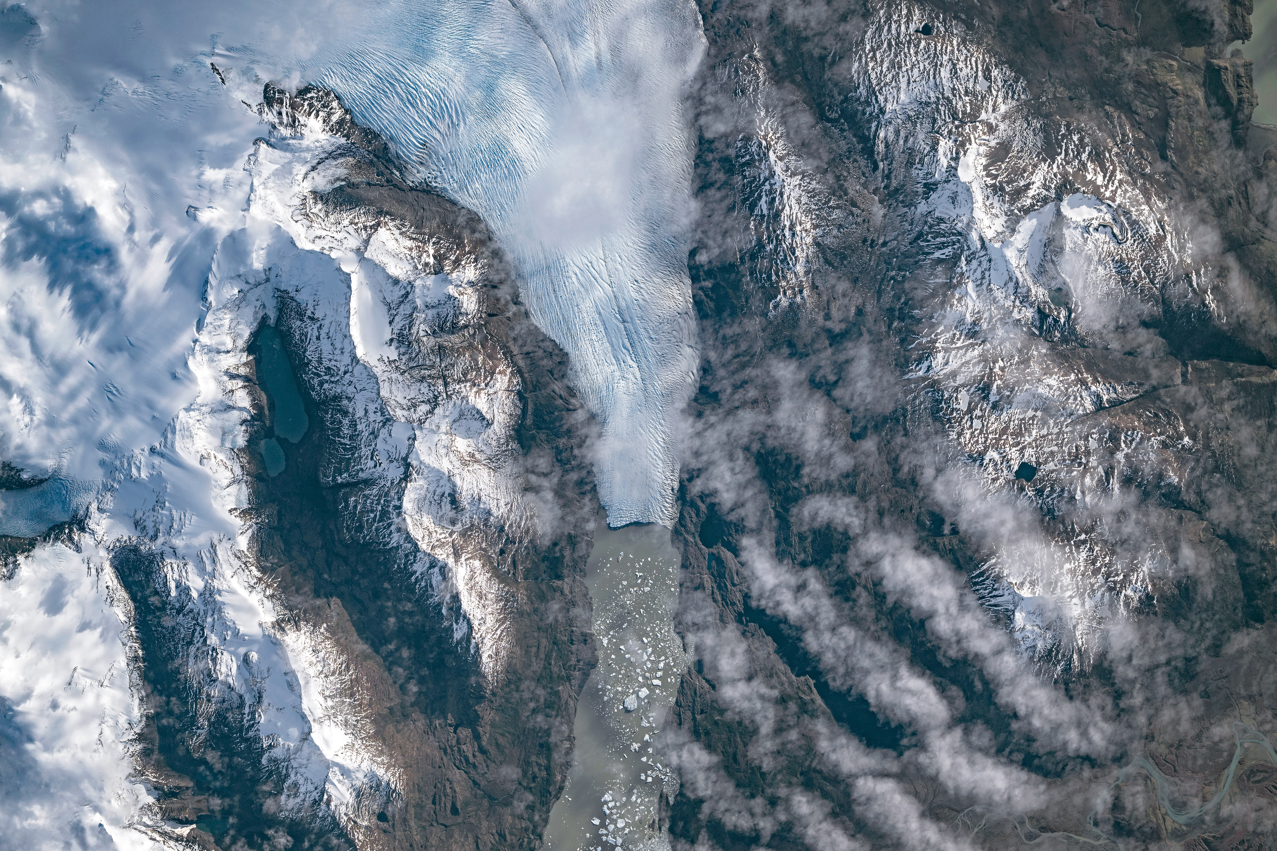
A top-down photo shows a glacier running from north to south amid snowy, mountainous terrain. The glacier flows into a narrow lake where many small icebergs are visible floating on the water.
May 10, 2026

The Southern Patagonian Icefield is the largest expanse of ice in the Southern Hemisphere outside of Antarctica. The mass of glacial ice extends hundreds of kilometers along the spine of the Andes, feeding dozens of dynamic outlet glaciers that grind their way down from higher elevations. Many of these rivers of ice terminate in the sea or in proglacial lakes.

An astronaut aboard the International Space Station photographed one of these glaciers—Tyndall Glacier in southern Chile—through a layer of ethereal clouds on May 10, 2026. Fragments of ice that had calved off its terminus were visible floating on Lago Geikie.

Like most Patagonian glaciers, Tyndall has been shrinking since the end of the Little Ice Age about 150 years ago. Lago Geikie formed at Tyndall’s terminus around 1940, according to glaciologist Mauri Pelto of Nichols College, and gradually expanded as the ice retreated. Part of the glacier previously terminated in Lago Tyndall to the east, but thinning ice cut off that outlet by 2010, Pelto said. (The ice’s retreat also exposed bedrock along its eastern edge that contains scores of ichthyosaur fossils.)

Along with thinning, ice calving off the glacier’s front has reduced its volume. Tyndall has lost 2.2 kilometers (1.4 miles) in length since November 2022, Pelto said, following about a decade of limited retreat with considerable thinning. A significant calving event in March and April 2023 contributed to the recent uptick in ice retreat. During that time, satellites observed several large icebergs breaking away from Tyndall’s terminus.

Austral autumn in 2026 was a time of active calving retreat at Tyndall (and some neighboring glaciers), Pelto said, albeit more incremental than three years prior. “The substantial crevasses crisscrossing the glacier near the calving front lead to many smaller icebergs,” he said. On the other hand, larger tabular icebergs tend to form when there are fewer deep crevasses near the terminus and the glacier’s ice is thinner.

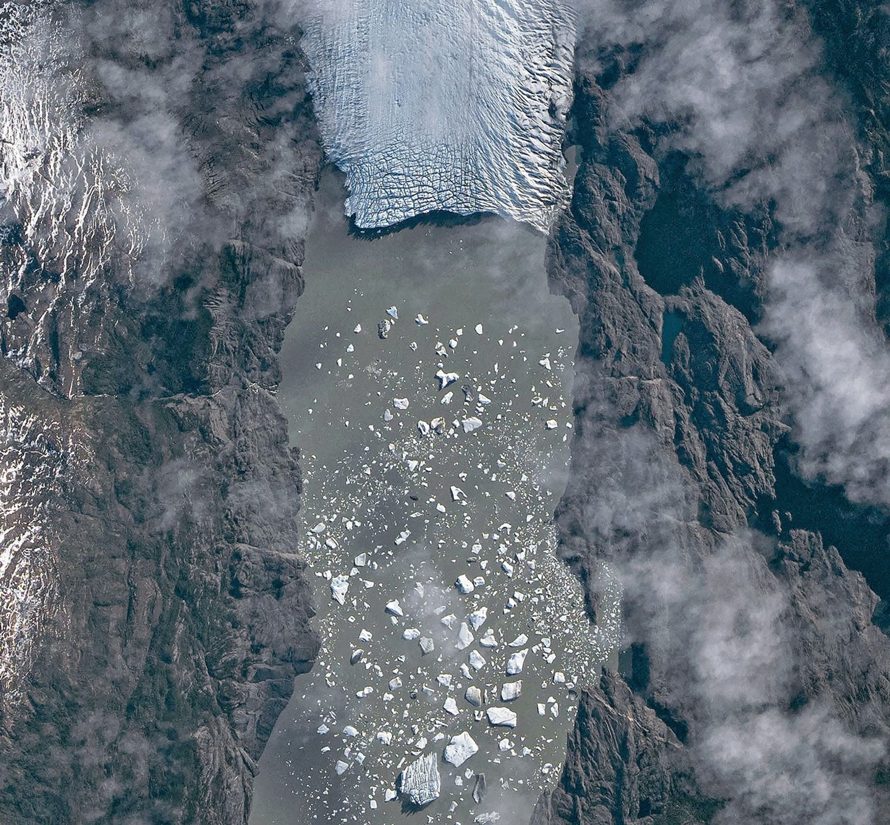
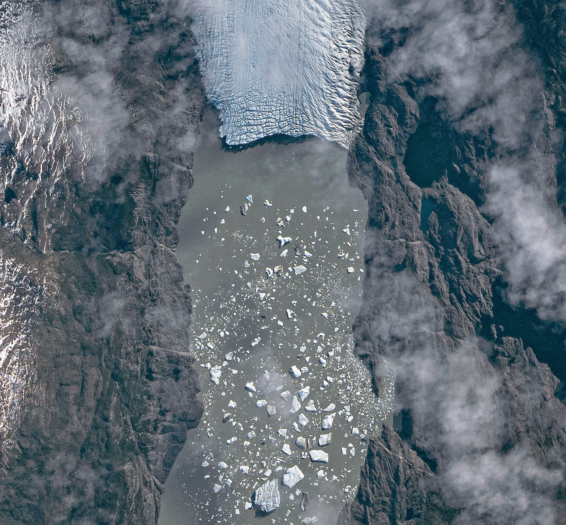
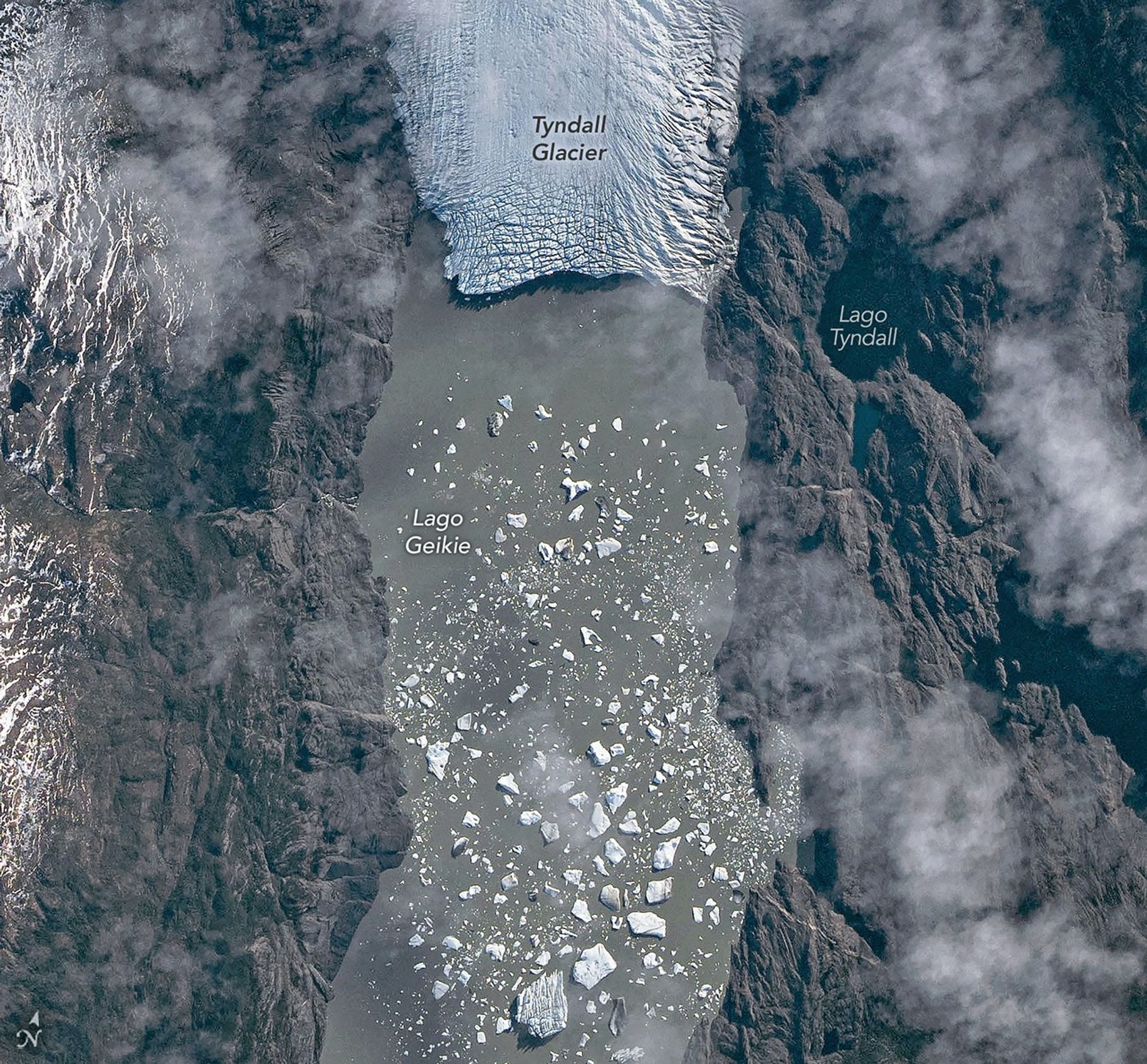
A top-down photo shows a detailed view of the leading edge of a glacier terminating in a lake. The glacial ice is heavily crevassed with intersecting linear features.
May 10, 2026

The ice cliff at the terminus casts a substantial shadow, which can help scientists estimate the height of the glacier’s front. Pelto’s calculations, using information about the Sun’s position provided with the image, indicate that Tyndall’s front loomed 30–40 meters (100–130 feet) above the lake surface in May 2026. Observations from orbit, including astronaut photographs, can help scientists monitor and understand glaciers in remote regions where ground-based observations are scarce.

As for what comes next for Tyndall, Pelto expects many more small icebergs to continue breaking off, given the heavily crevassed appearance of the calving front. “Look for a burst of iceberg production next fall.”

Astronaut photograph ISS074-E-582898 was acquired on May 10, 2026, with a Nikon Z9 digital camera using a focal length of 560 millimeters. It is provided by the ISS Crew Earth Observations Facility and the Earth Science and Remote Sensing Unit at NASA Johnson Space Center. The image was taken by a member of the Expedition 74 crew. The image has been cropped and enhanced to improve contrast, and lens artifacts have been removed. The International Space Station Program supports the laboratory as part of the ISS National Lab to help astronauts take pictures of Earth that will be of the greatest value to scientists and the public, and to make those images freely available on the Internet. Additional images taken by astronauts and cosmonauts can be viewed at the NASA/JSC Gateway to Astronaut Photography of Earth. Story by Lindsey Doermann.

Downloads

A top-down photo shows a glacier running from north to south amid snowy, mountainous terrain. The glacier flows into a narrow lake where many small icebergs are visible floating on the water.

May 10, 2026 (wide)

JPEG (11.19 MB)

A top-down photo shows a detailed view of the leading edge of a glacier terminating in a lake. The glacial ice is heavily crevassed with intersecting linear features.

May 10, 2026 (detailed)

JPEG (3.43 MB)

References & Resources

You may also be interested in:

Stay up-to-date with the latest content from NASA as we explore the universe and discover more about our home planet.

Record-Setting Retreat of Hektoria Glacier
5 min read

Scientists relied on satellite data to understand how the Antarctic glacier lost so much ice so rapidly.

Article
Stonebreen’s Beating Heart
3 min read

The glacier in southeastern Svalbard pulses with the changing seasons, speeding up and slowing its flow toward the sea.

Article
Cañon Fiord’s Whirling Waters
3 min read

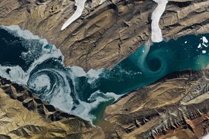
During the 2022 summer melt season, sediment plumes and fractured sea ice traced swirling eddies in a branch of the…

Article

The post Tyndall’s Trail of Bergs appeared first on NASA Science.

  •  

Tyndall’s Trail of Bergs

A top-down photo shows a glacier running from north to south amid snowy, mountainous terrain. The glacier flows into a narrow lake where many small icebergs are visible floating on the water.
May 10, 2026

The Southern Patagonian Icefield is the largest expanse of ice in the Southern Hemisphere outside of Antarctica. The mass of glacial ice extends hundreds of kilometers along the spine of the Andes, feeding dozens of dynamic outlet glaciers that grind their way down from higher elevations. Many of these rivers of ice terminate in the sea or in proglacial lakes.

An astronaut aboard the International Space Station photographed one of these glaciers—Tyndall Glacier in southern Chile—through a layer of ethereal clouds on May 10, 2026. Fragments of ice that had calved off its terminus were visible floating on Lago Geikie.

Like most Patagonian glaciers, Tyndall has been shrinking since the end of the Little Ice Age about 150 years ago. Lago Geikie formed at Tyndall’s terminus around 1940, according to glaciologist Mauri Pelto of Nichols College, and gradually expanded as the ice retreated. Part of the glacier previously terminated in Lago Tyndall to the east, but thinning ice cut off that outlet by 2010, Pelto said. (The ice’s retreat also exposed bedrock along its eastern edge that contains scores of ichthyosaur fossils.)

Along with thinning, ice calving off the glacier’s front has reduced its volume. Tyndall has lost 2.2 kilometers (1.4 miles) in length since November 2022, Pelto said, following about a decade of limited retreat with considerable thinning. A significant calving event in March and April 2023 contributed to the recent uptick in ice retreat. During that time, satellites observed several large icebergs breaking away from Tyndall’s terminus.

Austral autumn in 2026 was a time of active calving retreat at Tyndall (and some neighboring glaciers), Pelto said, albeit more incremental than three years prior. “The substantial crevasses crisscrossing the glacier near the calving front lead to many smaller icebergs,” he said. On the other hand, larger tabular icebergs tend to form when there are fewer deep crevasses near the terminus and the glacier’s ice is thinner.

A top-down photo shows a detailed view of the leading edge of a glacier terminating in a lake. The glacial ice is heavily crevassed with intersecting linear features.
May 10, 2026

The ice cliff at the terminus casts a substantial shadow, which can help scientists estimate the height of the glacier’s front. Pelto’s calculations, using information about the Sun’s position provided with the image, indicate that Tyndall’s front loomed 30–40 meters (100–130 feet) above the lake surface in May 2026. Observations from orbit, including astronaut photographs, can help scientists monitor and understand glaciers in remote regions where ground-based observations are scarce.

As for what comes next for Tyndall, Pelto expects many more small icebergs to continue breaking off, given the heavily crevassed appearance of the calving front. “Look for a burst of iceberg production next fall.”

Astronaut photograph ISS074-E-582898 was acquired on May 10, 2026, with a Nikon Z9 digital camera using a focal length of 560 millimeters. It is provided by the ISS Crew Earth Observations Facility and the Earth Science and Remote Sensing Unit at NASA Johnson Space Center. The image was taken by a member of the Expedition 74 crew. The image has been cropped and enhanced to improve contrast, and lens artifacts have been removed. The International Space Station Program supports the laboratory as part of the ISS National Lab to help astronauts take pictures of Earth that will be of the greatest value to scientists and the public, and to make those images freely available on the Internet. Additional images taken by astronauts and cosmonauts can be viewed at the NASA/JSC Gateway to Astronaut Photography of Earth. Story by Lindsey Doermann.

Downloads

A top-down photo shows a glacier running from north to south amid snowy, mountainous terrain. The glacier flows into a narrow lake where many small icebergs are visible floating on the water.

May 10, 2026 (wide)

JPEG (11.19 MB)

A top-down photo shows a detailed view of the leading edge of a glacier terminating in a lake. The glacial ice is heavily crevassed with intersecting linear features.

May 10, 2026 (detailed)

JPEG (3.43 MB)

References & Resources

You may also be interested in:

Stay up-to-date with the latest content from NASA as we explore the universe and discover more about our home planet.

Record-Setting Retreat of Hektoria Glacier

5 min read

Scientists relied on satellite data to understand how the Antarctic glacier lost so much ice so rapidly.

Article

Stonebreen’s Beating Heart

3 min read

The glacier in southeastern Svalbard pulses with the changing seasons, speeding up and slowing its flow toward the sea.

Article

Cañon Fiord’s Whirling Waters

3 min read

During the 2022 summer melt season, sediment plumes and fractured sea ice traced swirling eddies in a branch of the…

Article
  •  
❌