❌

Reading view

Purple Haze Aurora

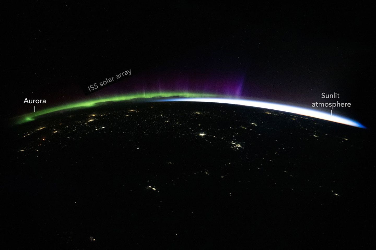
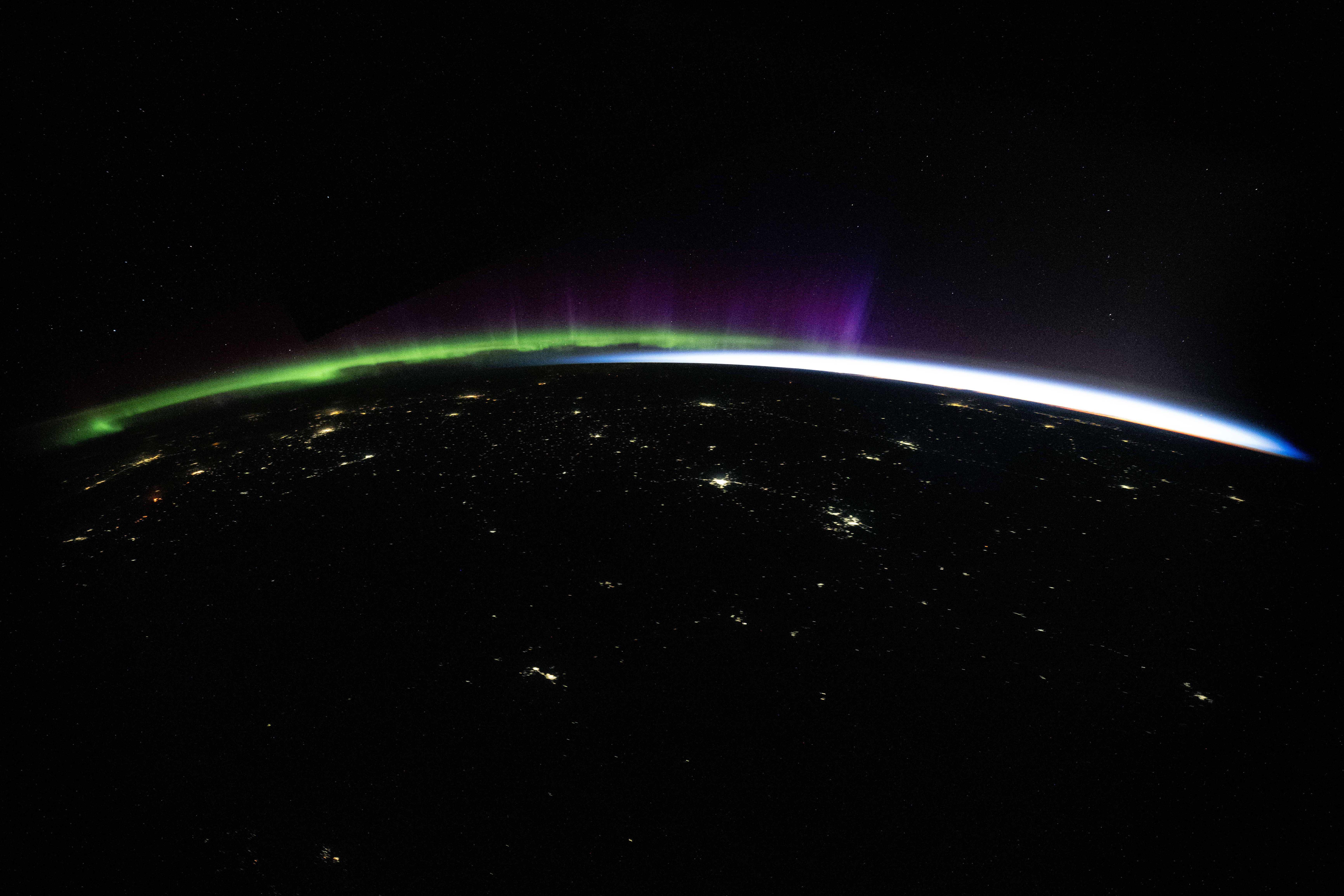
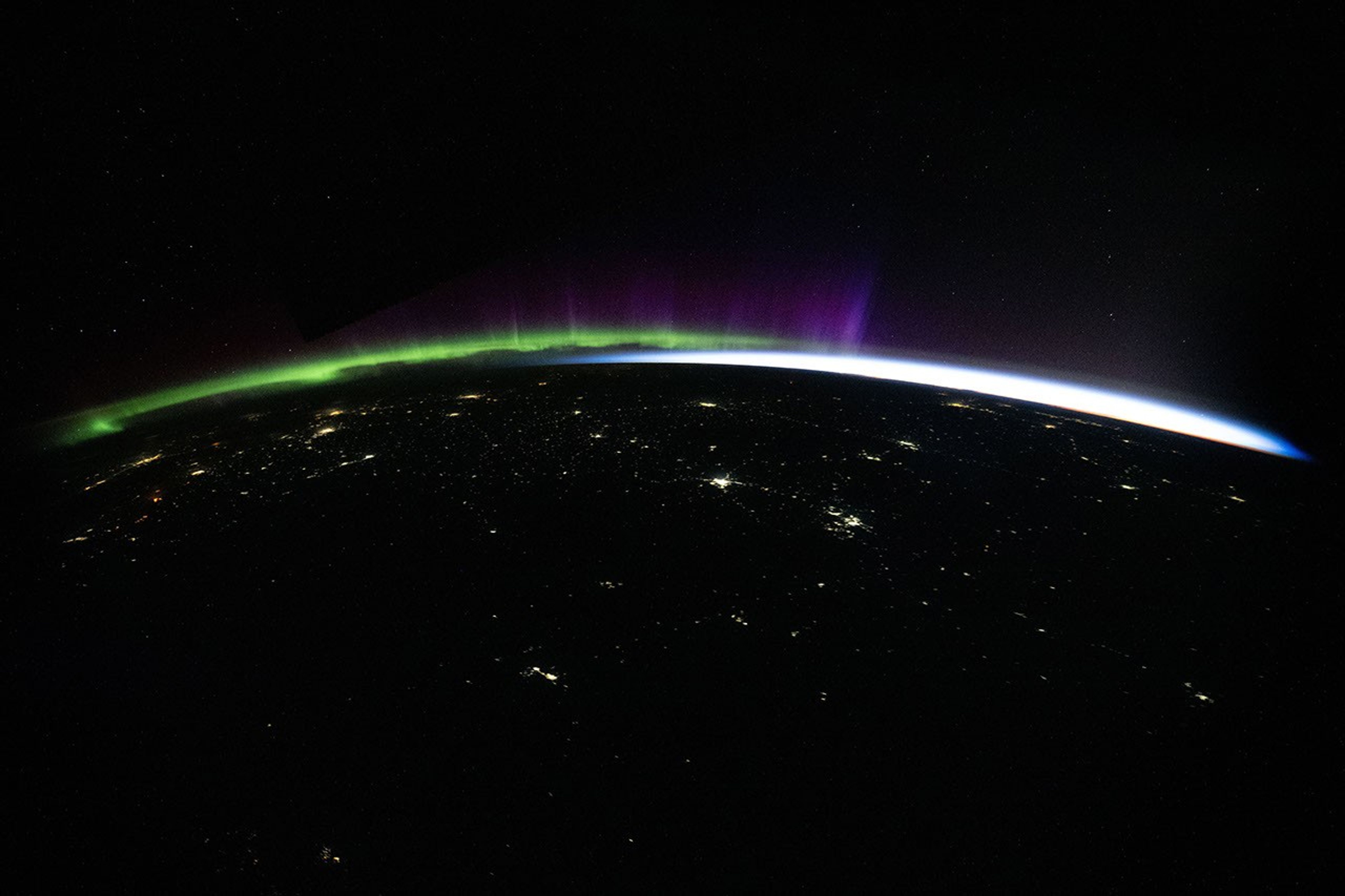
Green and purple aurora and white airglow arc above Earth’s limb and the scattered city lights of Central Asia in a nighttime photo taken from the International Space Station.

One of the inspirations for Jimi Hendrix’s iconic 1967 hit “Purple Haze” is said to be the sci-fi novel Night of Light, about a distant planet in a binary star system. Every seven years, the story goes, the stars bathe the planet in a bizarre purple radiance with the power to rearrange physical reality in profound and unexpected ways. The atmosphere’s purple glow, for instance, turned some people into trees and brought statues to life.

It’s perhaps fitting, then, for an astronaut on the International Space Station to invoke the iconic song after witnessing the aurora illuminate Earth’s atmosphere with ethereal greens, reds, and purples. Hendrix would have “rejoiced” at the “brilliant purple,” NASA astronaut Jessica Meir posted on September 8. It “makes me want to kiss the sky,” she added in a nod to the lyrics of the Hendrix song.

The photograph above is one of many that the astronauts took on September 7, 2026, as they orbited an atmosphere quivering with color. The station was at an altitude of 255 miles (411 kilometers) and above Kyrgyzstan when the photo was taken. Stacking several of the photos also yielded a long-exposure series in which the aurora’s green glow mingles with star trails, moonlight, passing satellites, and city lights in a dazzling jumble of illumination.

Aurora is the Latin word for “dawn” and also the name of the Roman goddess of the dawn. Its use in reference to the atmospheric phenomenon likely comes from Europeans living far from the Arctic Circle, who would have experienced the aurora as a faint red glow to the north, resembling the reddish glow in the east at dawn.

The colorful phenomenon typically starts when the Sun sends charged particles toward Earth through solar flares, coronal mass ejections (CMEs), or an active solar wind. These particles interact with the magnetosphere—the invisible, comet-shaped bubble of magnetic field lines surrounding the planet—compressing and changing the configuration of the magnetic field. In the process, some particles within the field are drawn into Earth’s upper atmosphere, where they excite nitrogen and oxygen atoms and molecules, causing them to release photons.

The aurora Meir photographed occurred amid a disturbance associated with a high-speed stream of solar wind from a coronal hole and the lingering effects of multiple coronal mass ejections, according to updates from NOAA’s Space Weather Prediction Center. These solar wind disturbances interacted with Earth’s magnetosphere, causing minor (G1) geomagnetic storms.

The colors of auroras are influenced by the type of gas involved and the altitude at which they occur in the atmosphere. Oxygen excited to different energy levels can produce green and red. Green occurs roughly between 60 and 120 miles (100 and 200 kilometers) altitude, and red occurs above 120 miles (200 kilometers). Excited nitrogen gas, from about 60 to 120 miles (100 to 200 kilometers), glows blue or pink depending on the type and energy of the particles it interacts with. Sometimes, the light emitted by gases can appear to mix, making the auroras seem purple, pink, or even white.

While auroras can occur any time of the year, astronauts are especially likely to enjoy the light shows in the spring and fall, around the equinoxes. That’s because the geometry of Earth’s magnetic field relative to the solar wind makes it especially favorable for transferring solar-wind energy into the magnetosphere, a phenomenon known as the Russell-McPherron effect.

This isn’t the only example of Jimi Hendrix’s music making an impression beyond Earth. A selection of Hendrix’s music touched down on the Moon in 2024 with the Odysseus lander. Another Hendrix song, “Voodoo Chile,” made the list of wake-up songs for STS-110, according to a report from NASA’s History Division.

Astronaut photograph ISS075-E-88592 was acquired on September 7, 2026, with a Nikon Z9 digital camera using a focal length of 15 millimeters. It is provided by the ISS Crew Earth Observations Facility and the Earth Science and Remote Sensing Unit at NASA Johnson Space Center. The image was taken by a member of the Expedition 75 crew. The image has been cropped and enhanced to improve contrast, and lens artifacts have been removed. The International Space Station Program supports the laboratory as part of the ISS National Lab to help astronauts take pictures of Earth that will be of the greatest value to scientists and the public, and to make those images freely available on the internet. Additional images taken by astronauts and cosmonauts can be viewed at the NASA/JSC Gateway to Astronaut Photography of Earth. Story by Adam Voiland.
Downloads

Green and purple aurora and white airglow arc above Earth’s limb and the scattered city lights of Central Asia in a nighttime photo taken from the International Space Station.

September 7, 2026

JPEG (6.20 MB)

References & Resources

You may also be interested in:

Stay up-to-date with the latest content from NASA as we explore the universe and discover more about our home planet.
A Moonlit Earth as Seen From Artemis II
4 min read

An astronaut’s photo, taken en route to the Moon, reveals our planet and its place in space in a novel…
Article
Great Balls of Fire
4 min read

An astronaut on the International Space Station was surprised to photograph a shower of light streaking through the darkness while…
Article
The World Cup From 250 Miles Up
4 min read

Over the years, astronauts aboard the International Space Station have photographed several of the cities hosting the 2026 FIFA World…

Article

The post Purple Haze Aurora appeared first on NASA Science.
  •  

Stops Along the Path of Totality

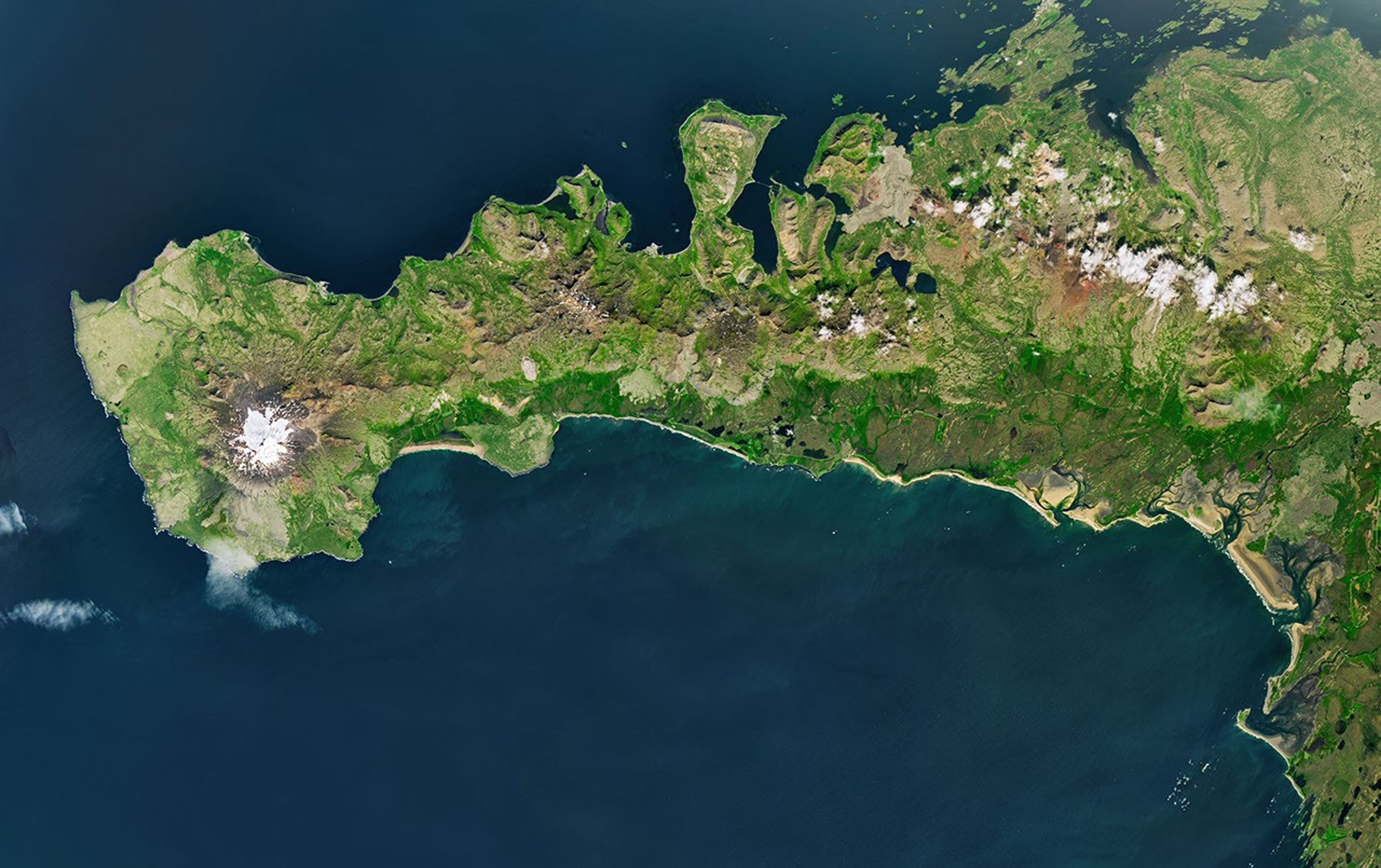
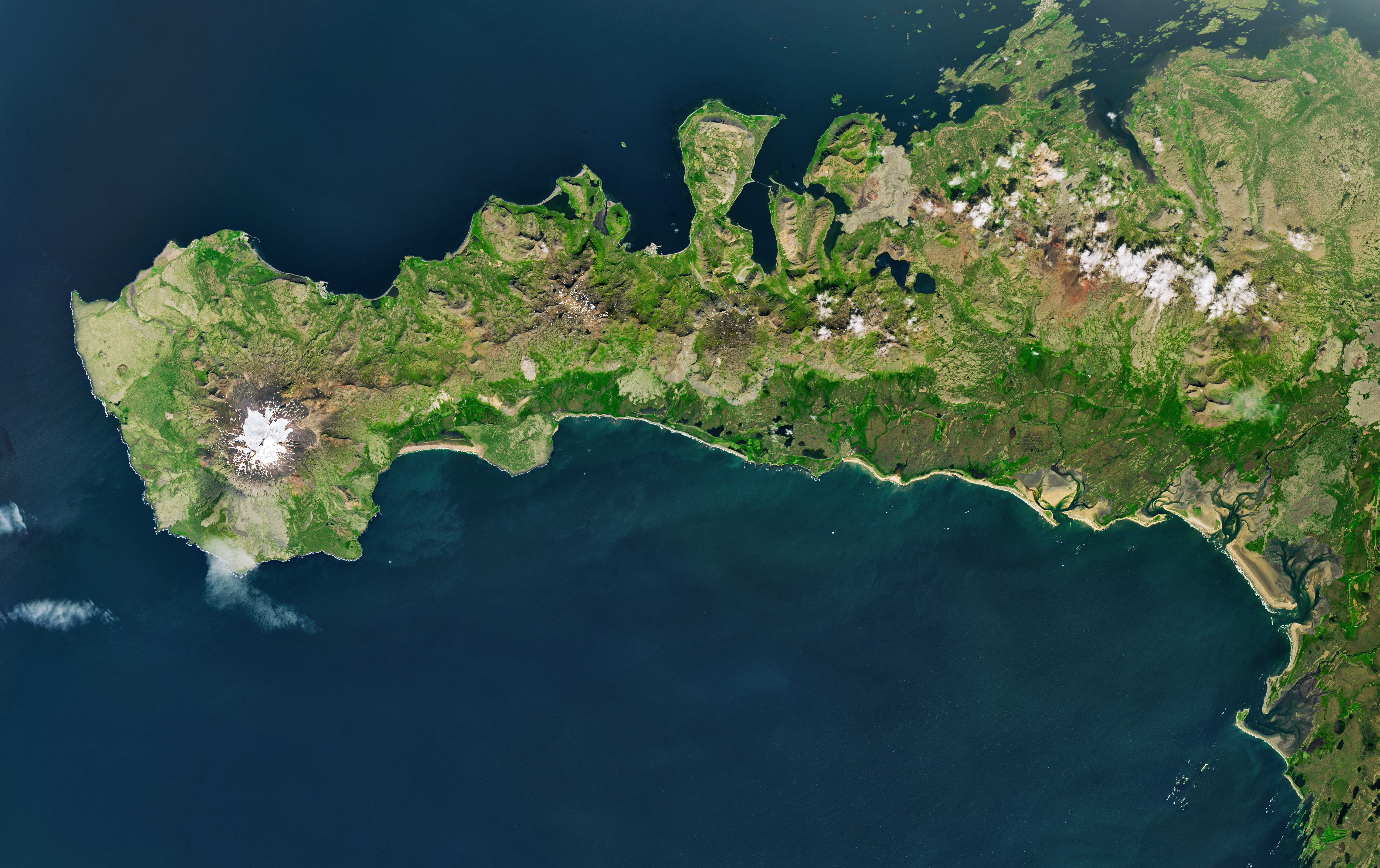
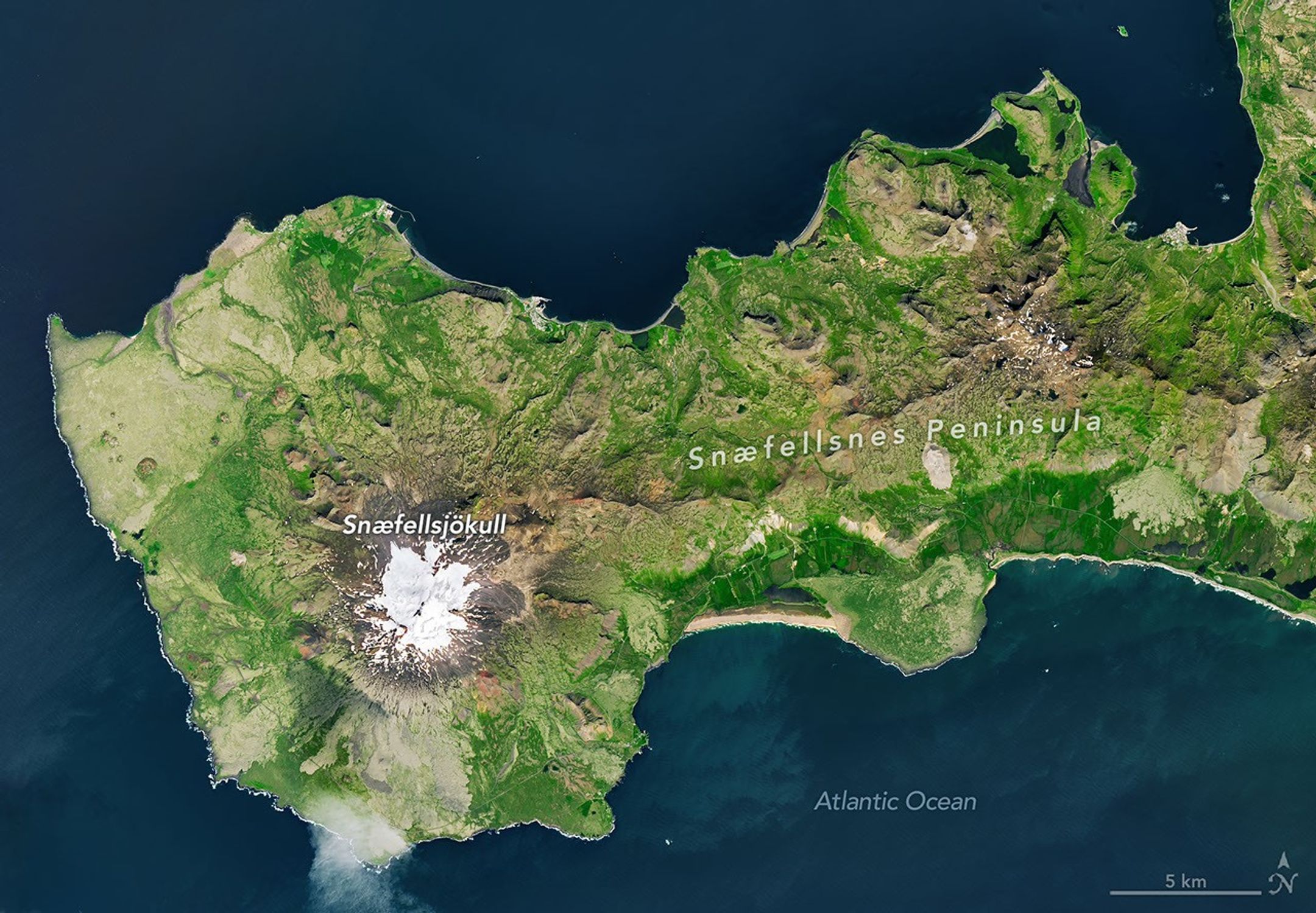
A peninsula in Iceland stretches across the image to the left. A prominent glacier-capped volcano sits near its western end.
The glacier-capped Snæfellsjökull volcano is the defining feature of Iceland’s Snæfellsnes peninsula, shown in this image acquired with the OLI (Operational Land Imager) on Landsat 9 on July 25, 2026.
NASA Earth Observatory/Michala Garrison

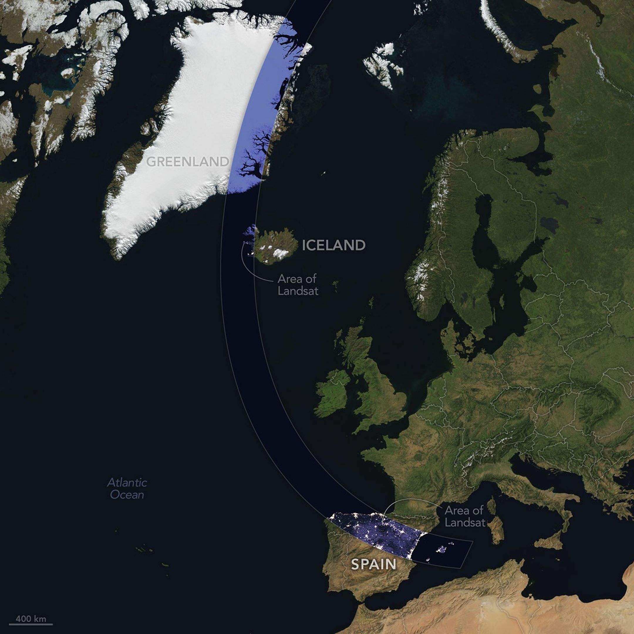
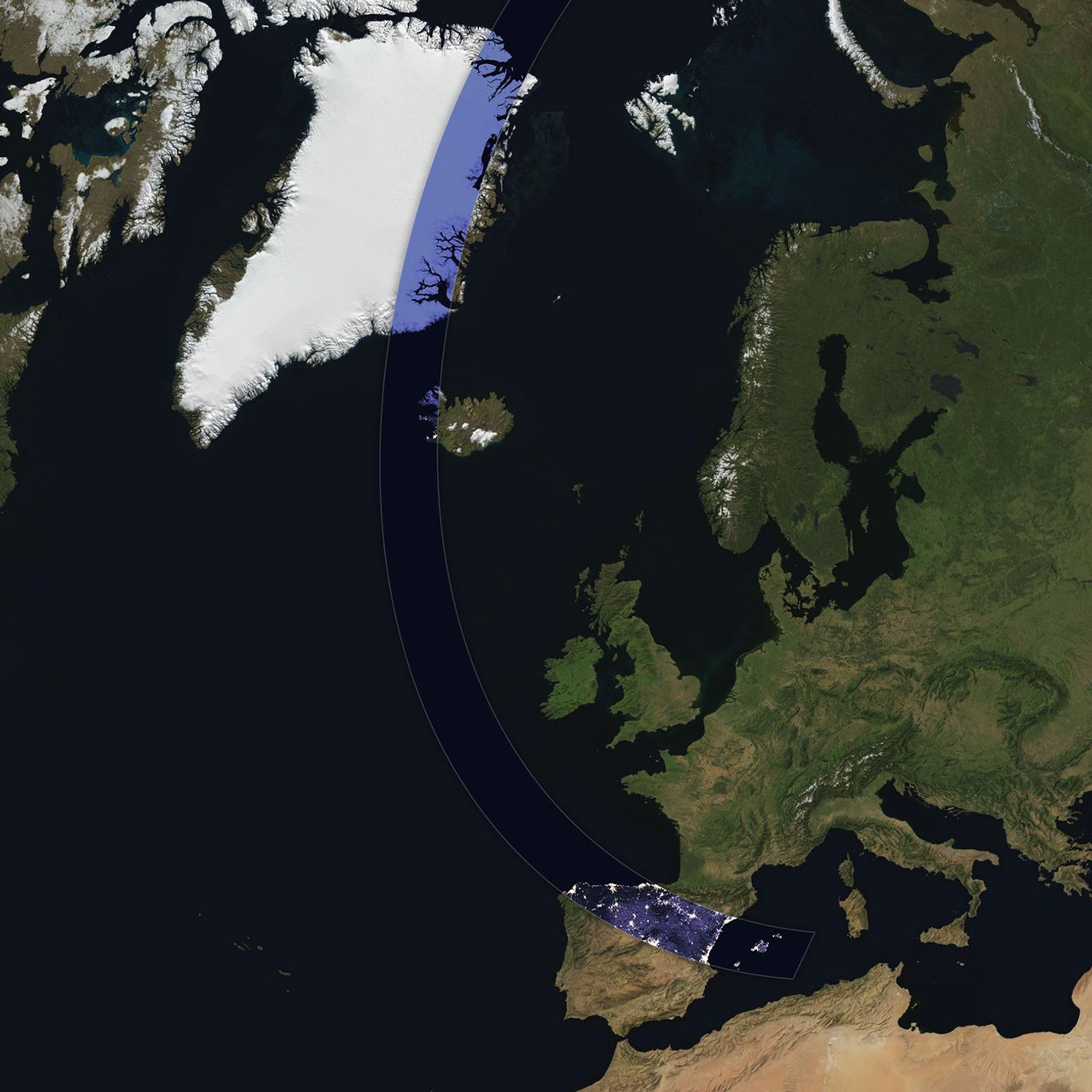
The Sun, Moon, and Earth align on August 12, 2026, to produce a total solar eclipse. When this celestial event last occurred, on April 8, 2024, the path of totality stretched across North America, giving millions the chance to glimpse the Sun’s corona. In 2026, the viewing locales are more limited; only a handful of land areas in the Northern Hemisphere, including parts of Iceland and Spain, fall within the path of totality.

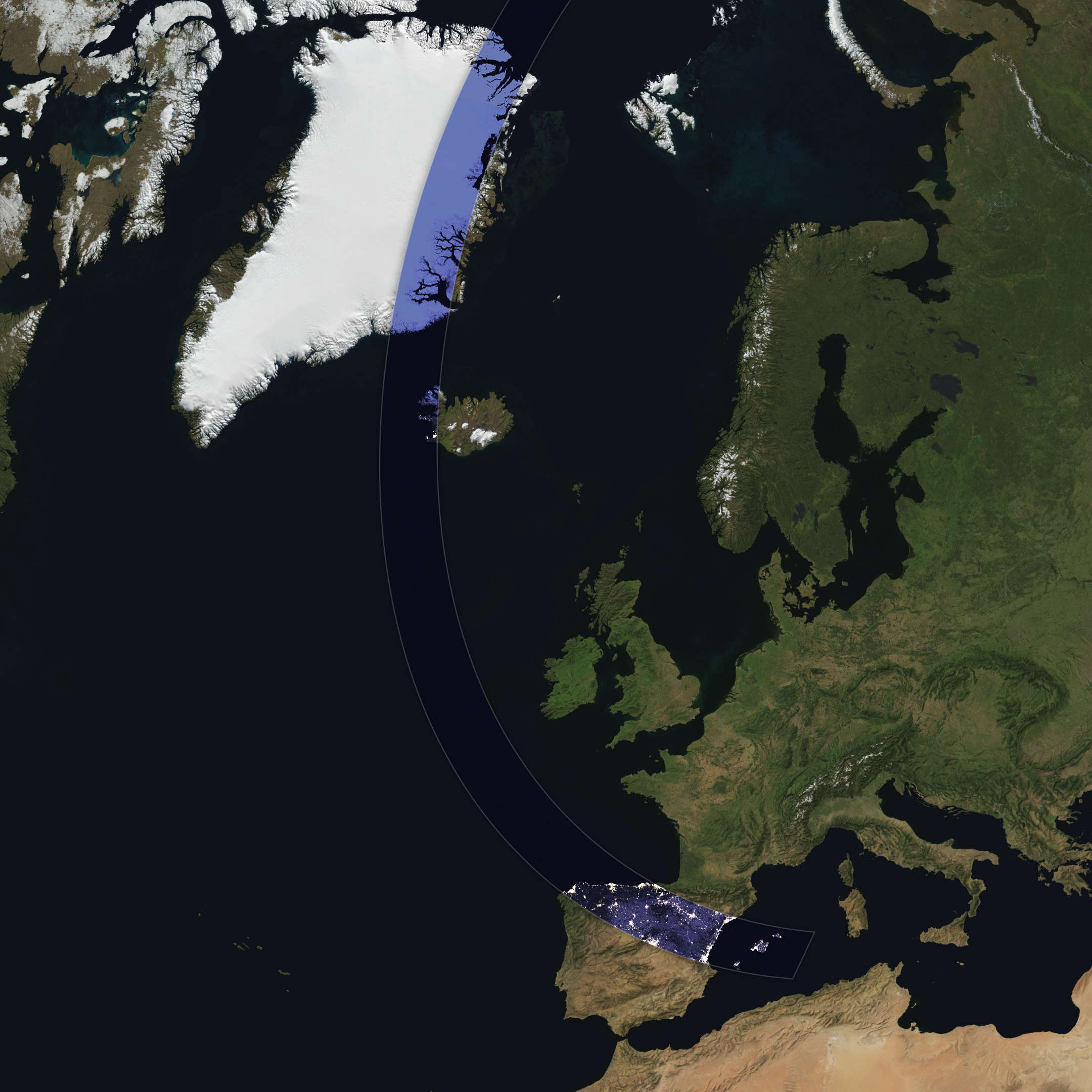
On August 12, the Moon’s shadow will first cross over the Arctic Circle from northern Russia and then track along the eastern side of Greenland. At about 5:45 p.m. local time in Iceland (17:45 Universal Time), the country’s western fringes—including the Snæfellsnes peninsula, shown in the Landsat image above—will begin to experience totality. The greatest eclipse will occur near this sparsely populated peninsula when the Moon appears the largest and covers more of the Sun.

A map shows the path of totality of the solar eclipse on August 12, 2026, arcing across Greenland, Iceland, the North Atlantic, and Spain.
The path of totality of the solar eclipse on August 12, 2026, spans Greenland, Iceland, and Spain. The base imagery for the map comes from Blue Marble: Next Generation, with data from Black Marble shown in the path of totality. Blue Marble is built from scenes captured by MODIS (Moderate Resolution Imaging Spectroradiometer), while Black Marble is based on observations by the VIIRS (Visible Infrared Imaging Radiometer Suite) day-night band.
NASA Earth Observatory/Michala Garrison

The Snæfellsjökull volcano on the western end of the peninsula is covered in ice and last erupted about 1,800 years ago. It is the highlight of a national park of the same name, where people are expected to visit to view the eclipse. The stratovolcano even has a literary claim to fame: in Jules Verne’s A Journey to the Center of the Earth, characters venture underground through its crater, later emerging in an eruption of Stromboli, in Italy. In 2025, a broader area of the peninsula was designated a UNESCO biosphere reserve, containing over 70 percent of Iceland’s flora and an agglomeration of volcanic landscapes, wetlands, and grasslands.

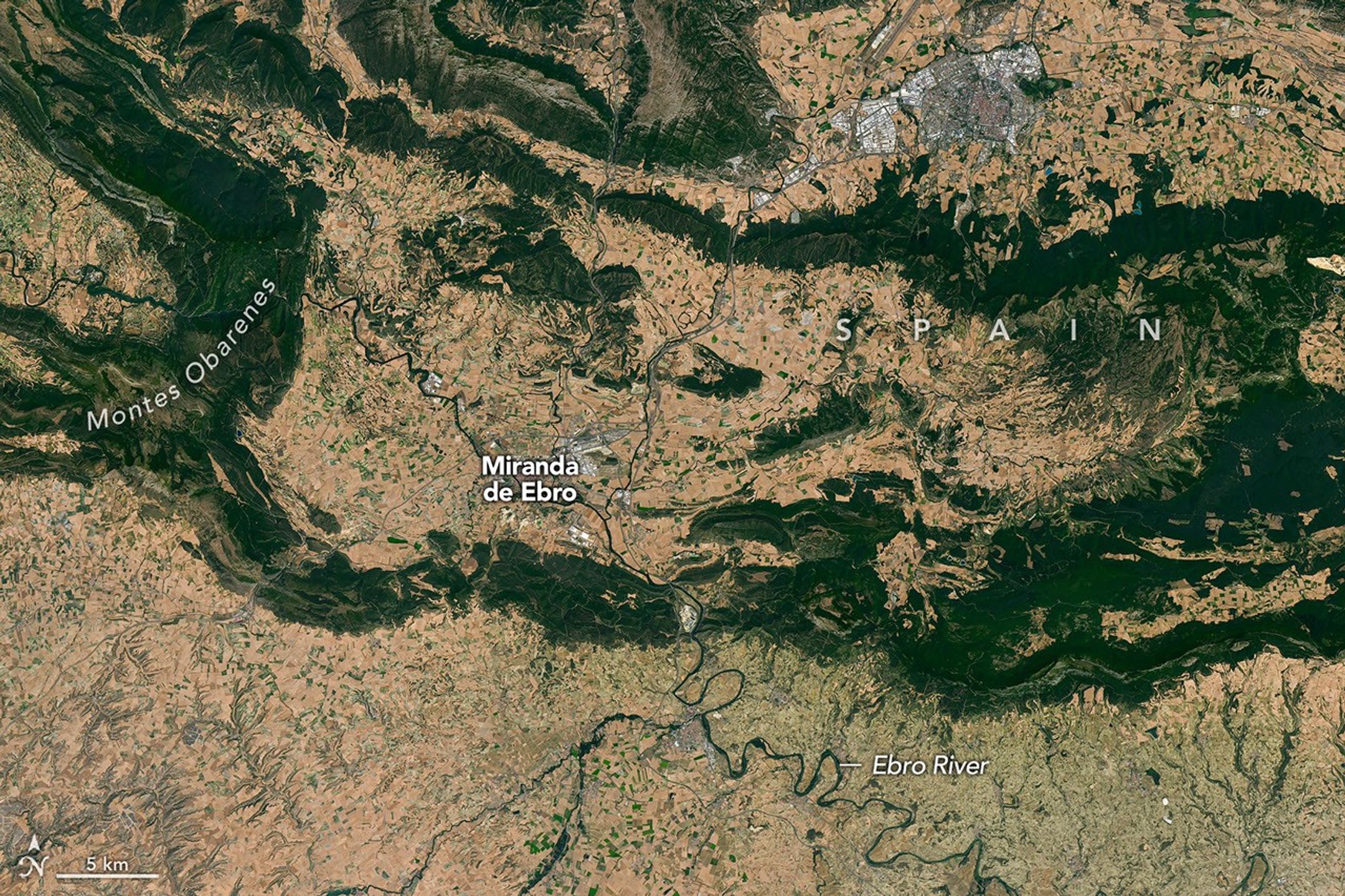
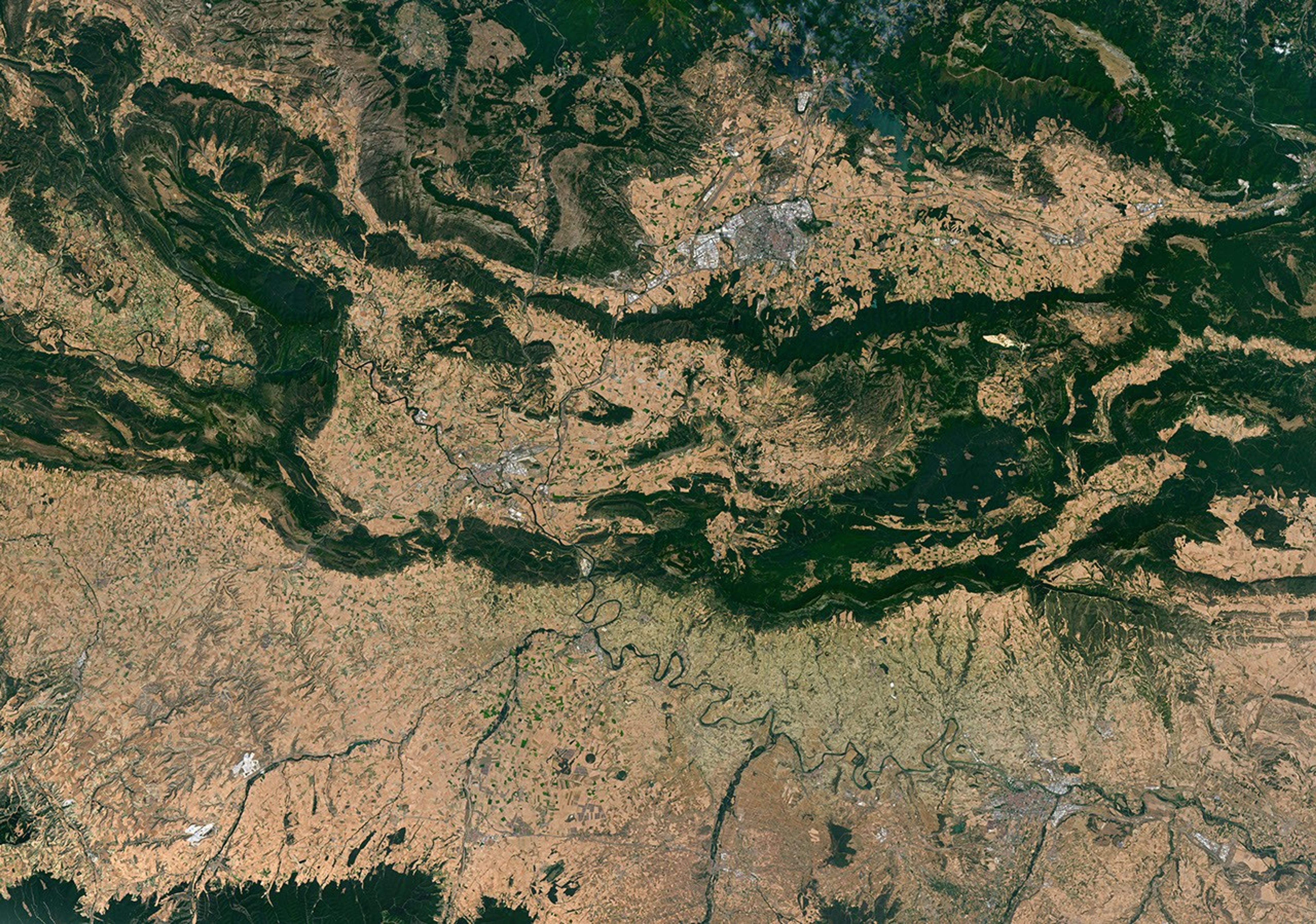
From Iceland, the eclipse shadow, or umbra, progresses across the North Atlantic and reaches northern Spain shortly before sunset. It runs east-southeast across the country, much like the Ebro River (Río Ebro), seen in the Landsat image below.

Meandering rivers cut through dark green mountain ridges, across agricultural land, and near several developed areas in northern Spain.

The Ebro River, meandering across northern Spain in this image acquired with the OLI (Operational Land Imager) on Landsat 8 on July 21, 2026, is in the path of totality of the August 2026 solar eclipse.
NASA Earth Observatory/Michala Garrison

The upper Ebro emerges from rugged terrain in Parque Natural de Montes Obarenes-San Zadornil, where it carves canyons and gorges through the eastern foothills of the Cantabrian Mountains. It then meanders through La Rioja, a region known for its vineyards. About 400 kilometers (250 miles) away, the river reaches a delta on the Mediterranean coast between Barcelona and Valencia.

Based on satellite measurements of cloud cover in August over several decades, viewers in Spain have a higher likelihood than those in Iceland of getting a clear look at the eclipse. And despite limited viewing opportunities in the path of totality, the rest of Europe, parts of Africa, Canada, and the northern and northeastern U.S. will experience a partial eclipse.

NASA Earth Observatory images and map by Michala Garrison, using Landsat data from the U.S. Geological Survey, base imagery from Blue Marble: Next Generation and Black Marble, and eclipse path data from Xavier Jubier. Story by Lindsey Doermann.

Downloads

A peninsula in Iceland stretches across the image to the left. A prominent glacier-capped volcano sits near its western end.

July 25, 2026

JPEG (14.69 MB)

A map shows the path of totality of the solar eclipse on August 12, 2026, arcing across Greenland, Iceland, the North Atlantic, and Spain.

August 12, 2026

JPEG (1.92 MB)

Meandering rivers cut through dark green mountain ridges, across agricultural land, and near several developed areas in northern Spain.


July 21, 2026

JPEG (34.46 MB)

References & Resources

You may also be interested in:

Stay up-to-date with the latest content from NASA as we explore the universe and discover more about our home planet.

Colonial National Historical Park

2 min read

The colonial communities of “America’s historic triangle” played defining roles in the road to American independence.

Article

Minute Man National Historical Park

3 min read

Sites relevant to the start of the American Revolutionary War are interspersed throughout the modern-day Boston metropolitan region.

Article

Earthset From the Lunar Far Side

2 min read

The crew of NASA’s Artemis II mission captured extraordinary images of our home planet during their journey around the far…

Article
  •  

A Moonlit Earth as Seen From Artemis II

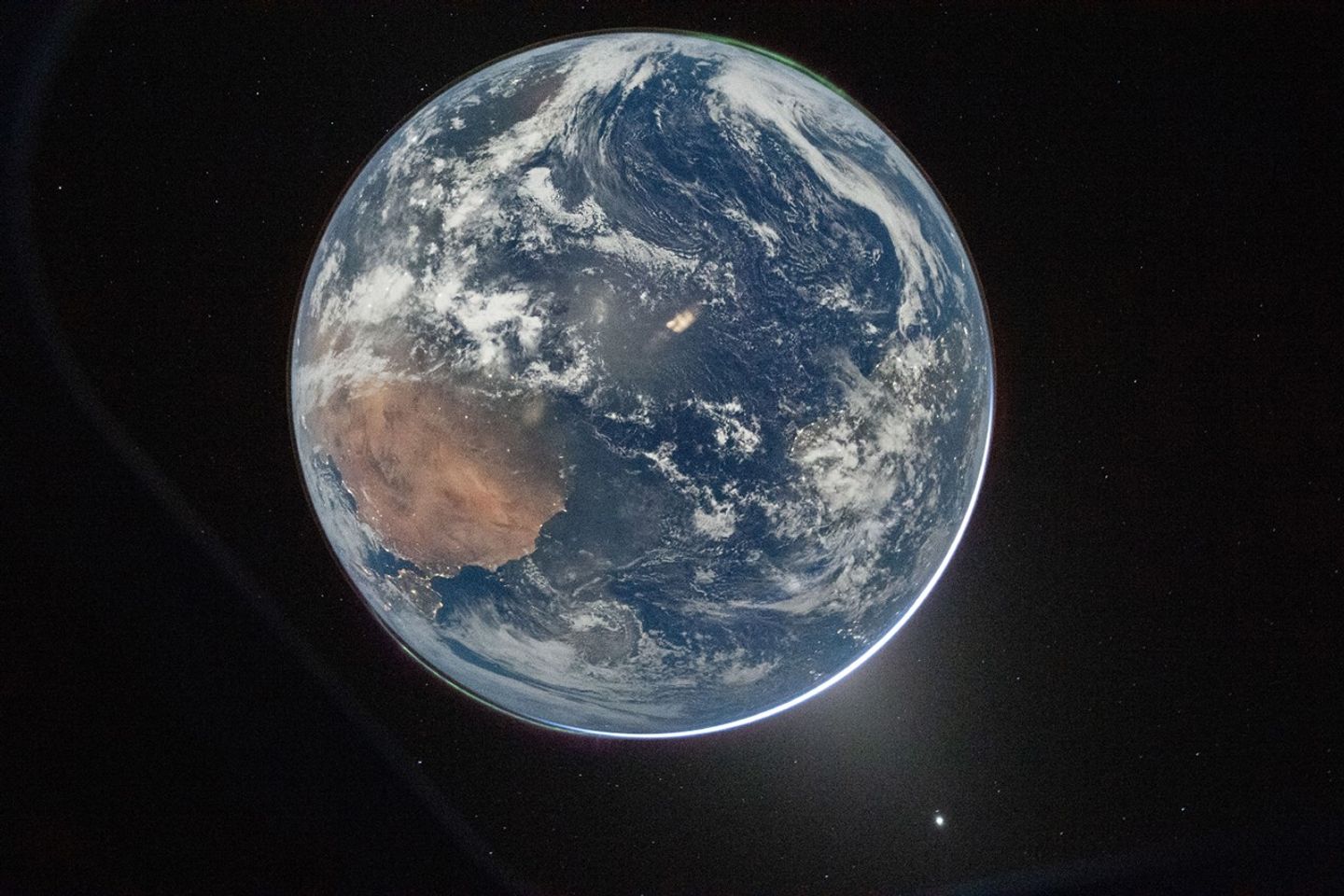
Earth’s full disk is seen through the window of a spacecraft. The glow of aurora, a sliver of the Sun, and fuzzy zodiacal light surround the planet, and city lights are visible on the continents.
April 2, 2026

One of the first images transmitted back to Earth from the Artemis II mission was a stunner. In a single image, Earth’s full disk appears amid celestial phenomena that illustrate its place in the solar system. And although the visible hemisphere appears to be awash in sunlight, it is actually lit by moonlight. The astronauts’ vantage point provided a rare opportunity to capture nighttime features—most notably lights from human habitation—from a new perspective.

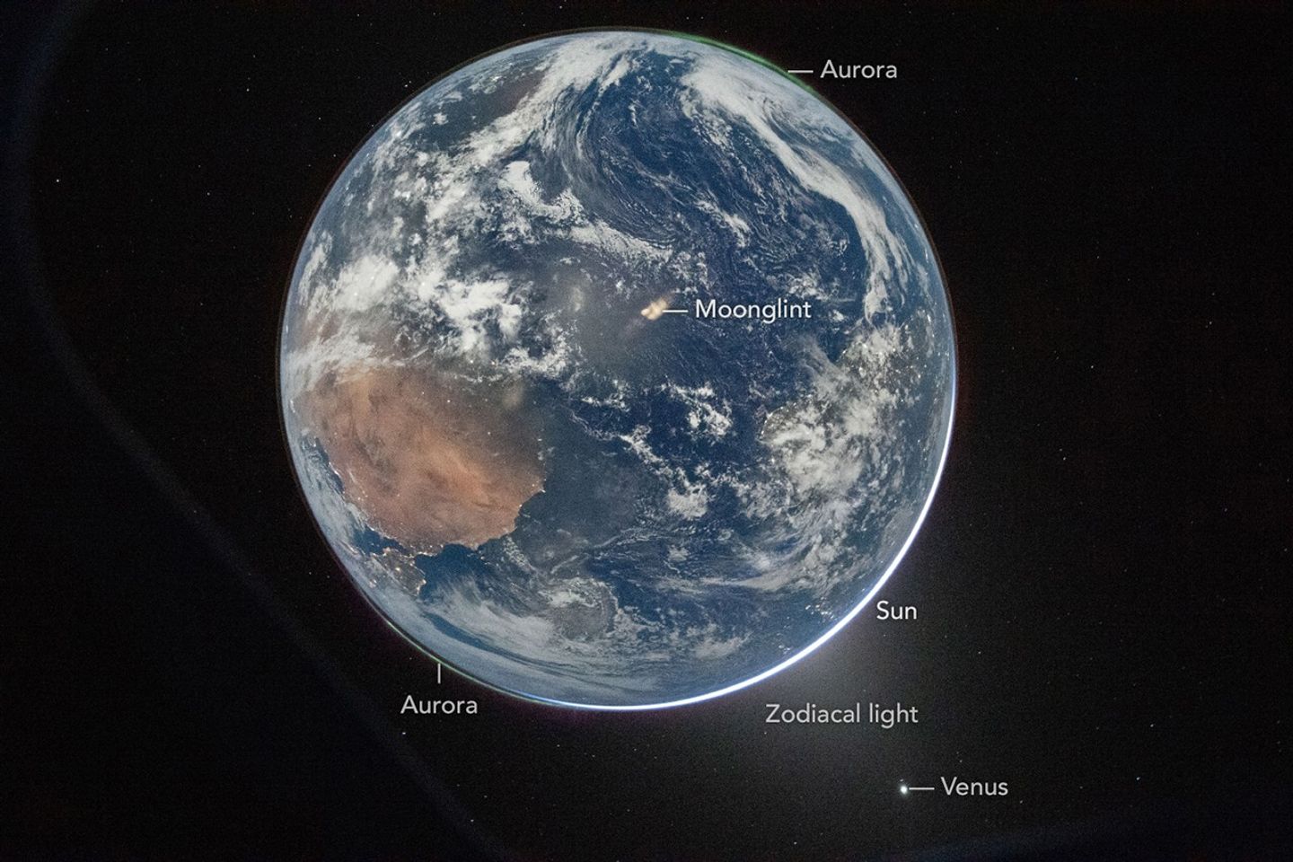
An Artemis crew member captured the photo from the Orion spacecraft after it completed the translunar injection burn, which sent the spacecraft out of Earth orbit and on a trajectory toward the Moon. In the photo, Earth eclipses the Sun from Orion’s perspective, leaving only a small sliver of its bright light visible around the bottom right edge. Green auroras, caused by charged particles from the Sun interacting with Earth’s upper atmosphere, glow around the north and south poles (lower left and upper right, respectively).

The Sun’s light also produces the fuzzy glow, known as zodiacal light, that appears to the lower right of Earth. This phenomenon comes from sunlight reflecting off interplanetary dust. Skywatchers on Earth may see it at certain times of year around dawn or dusk as a faint column of light extending up from the horizon. Data collected by NASA’s Juno spacecraft on its journey to Jupiter suggest that Mars may be a significant source of the dust particles that produce zodiacal light. Earth’s other planetary neighbor, Venus, appears as the bright object in the bottom right of the image.

Earth’s full disk is seen through the window of a spacecraft. Various features are labeled. The glow of aurora, a sliver of the Sun, and fuzzy zodiacal light surround the planet, and city lights are visible on the continents.
April 2, 2026

On Earth itself, city lights are evidence of human activity. Bright areas appear in Spain, Portugal, and northern Africa (lower left), sub-Saharan Africa (center left), and Brazil (center right). Digital camera technology—with help from the illumination of a full Moon—made it possible to see these and other details of Earth’s surface and atmosphere in low light. The crew set the camera’s ISO to 51,200 to make it highly sensitive to light. For comparison, an ISO setting of 100 or 200 is common for daytime photography.

Previous nighttime views of Earth taken from spacecraft may look very different from this photo but have also inspired and enlightened. For instance, the Apollo 12 crew photographed Earth eclipsing the Sun in 1969; astronaut Alan Bean would go on to depict his impressions of the event in paintings.

More recently, astronauts aboard the International Space Station have photographed the planet at night from low Earth orbit, while NASA’s Black Marble nighttime lights product suite uses satellite observations to produce science-quality records of nighttime lights at daily, monthly, and yearly time scales. Those programs provide sustained data records, while the Artemis II photo is distinctive as a single human-captured full-disk view showing many low-light features at once.

Cindy Evans, senior exploration scientist in the Astromaterials Research and Exploration Science Division at NASA’s Johnson Space Center, was working in the Science Evaluation Room during the Artemis II mission and was one of the first people on Earth to see the image. Evans was struck both by its beauty and the perspective revealed by all the visible solar system features. “I love the image so much because it was taken with Earth in moonshine, and shows Earth as a solar system body, a dynamic planet interacting with the solar wind, and a place harboring life,” she said.

The image is scientifically valuable, as well, said Miguel Román, Deputy Director for Atmospheres and Data Systems at NASA’s Goddard Space Flight Center. “It speaks powerfully to the breadth of what NASA does across science and human exploration,” he said. Román studies artificial light at night, as viewed from space, as a measurable signal of human activity.

“[This photo] reminds us that Earth at night is visually compelling, physically complex, and scientifically underexplored,” Román said. “I see this image as a glimpse of what Earth science can become in the future.”

NASA images prepared for Earth Observatory by Lauren Dauphin. Story by Lindsey Doermann.

References & Resources

You may also be interested in:

Stay up-to-date with the latest content from NASA as we explore the universe and discover more about our home planet.

Great Balls of Fire

4 min read

An astronaut on the International Space Station was surprised to photograph a shower of light streaking through the darkness while…

Article

Earthset From the Lunar Far Side

2 min read

The crew of NASA’s Artemis II mission captured extraordinary images of our home planet during their journey around the far…

Article

Shades of a Lunar Eclipse

3 min read

A series of nighttime satellite images revealed how moonlight reaching Earth varied throughout a total lunar eclipse.

Article
  •  
❌