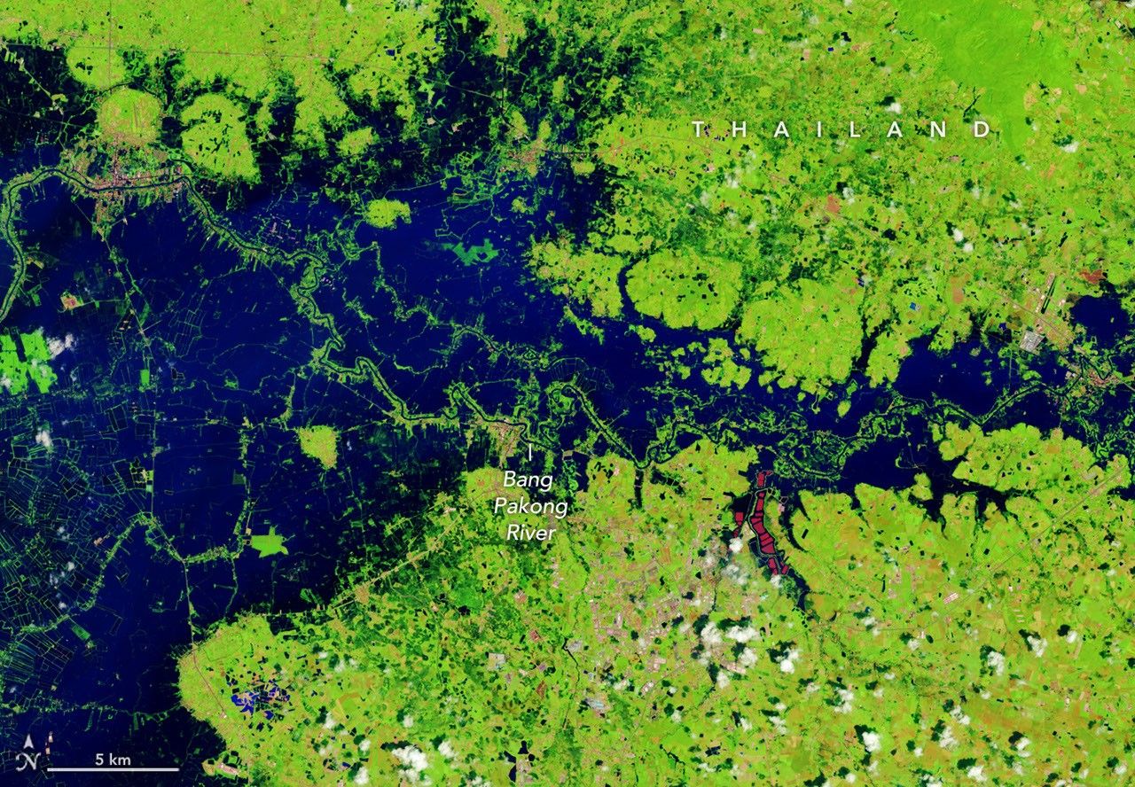
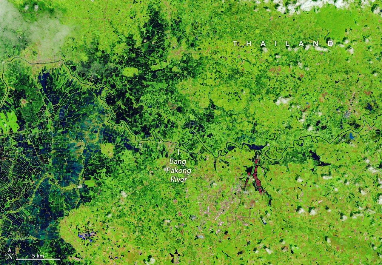
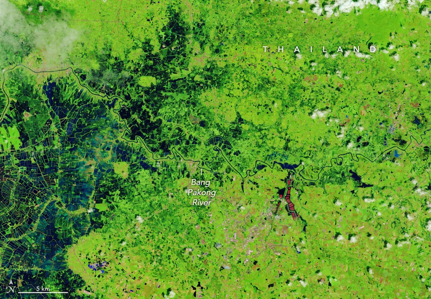
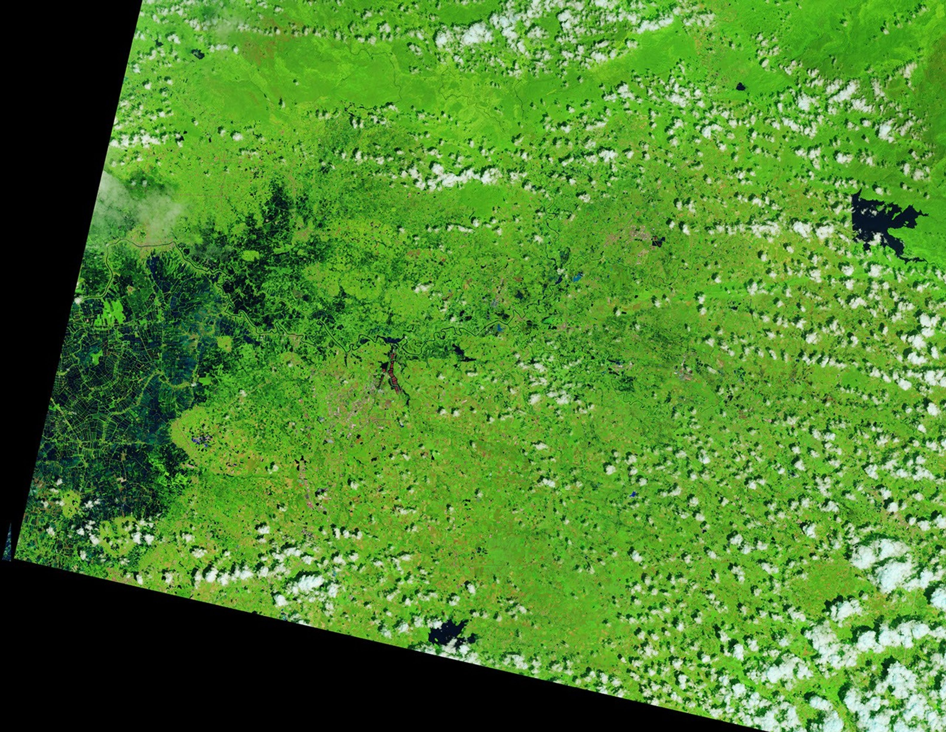
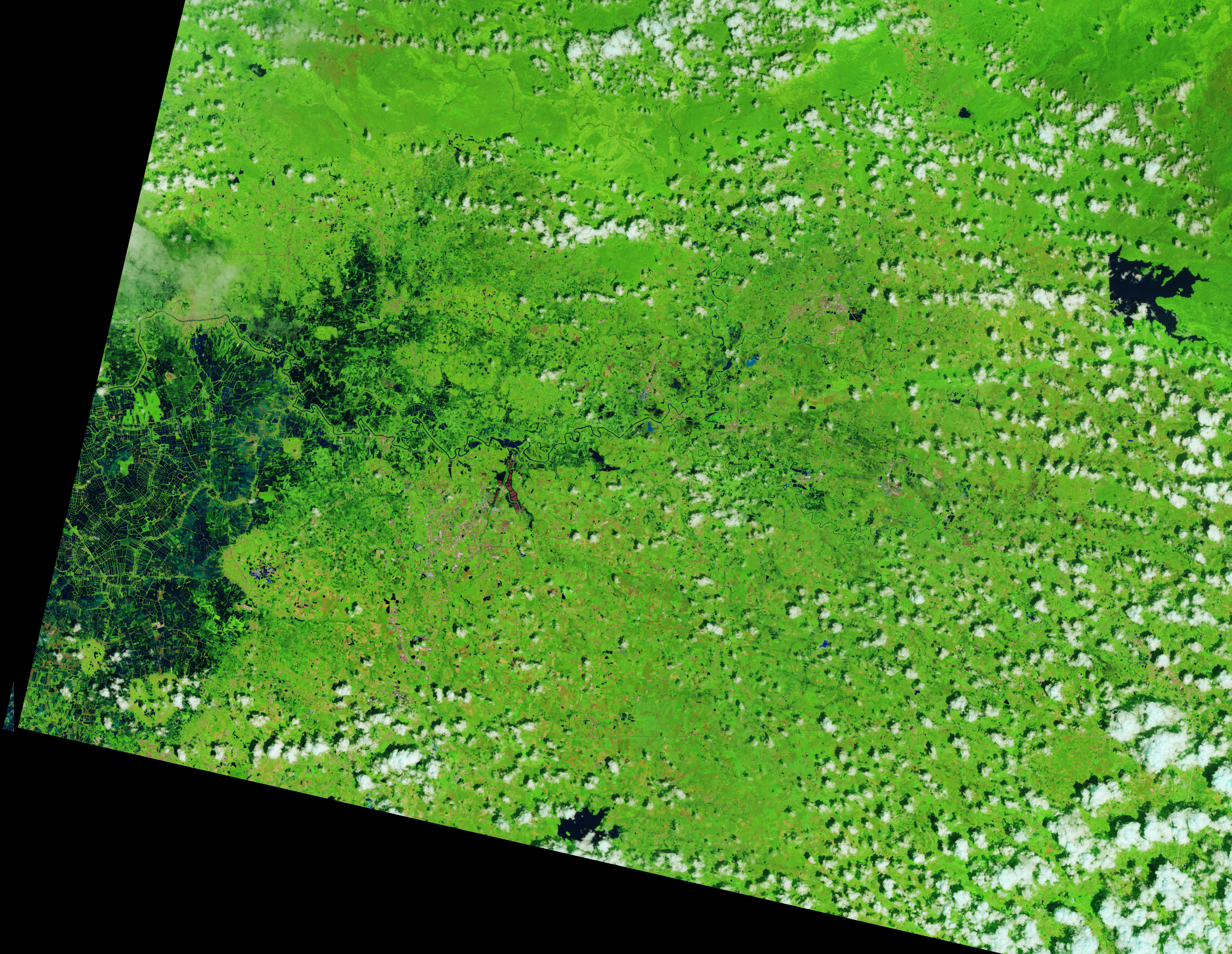
A narrow river (dark blue) meanders across vegetated land (bright green) in a false-color satellite image. Small geometric ponds or waterlogged fields appear on the left side of the scene.
NASA Earth Observatory / Lauren Dauphin
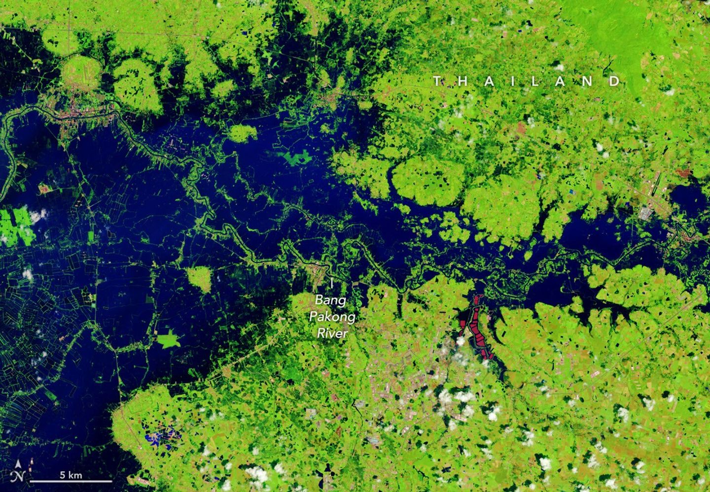
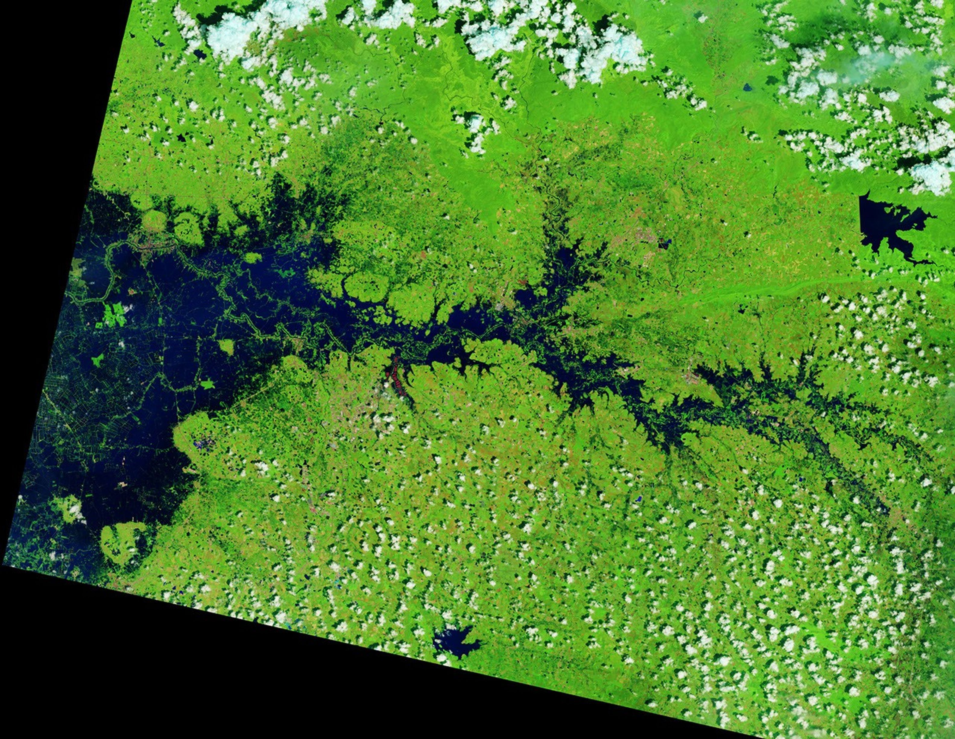
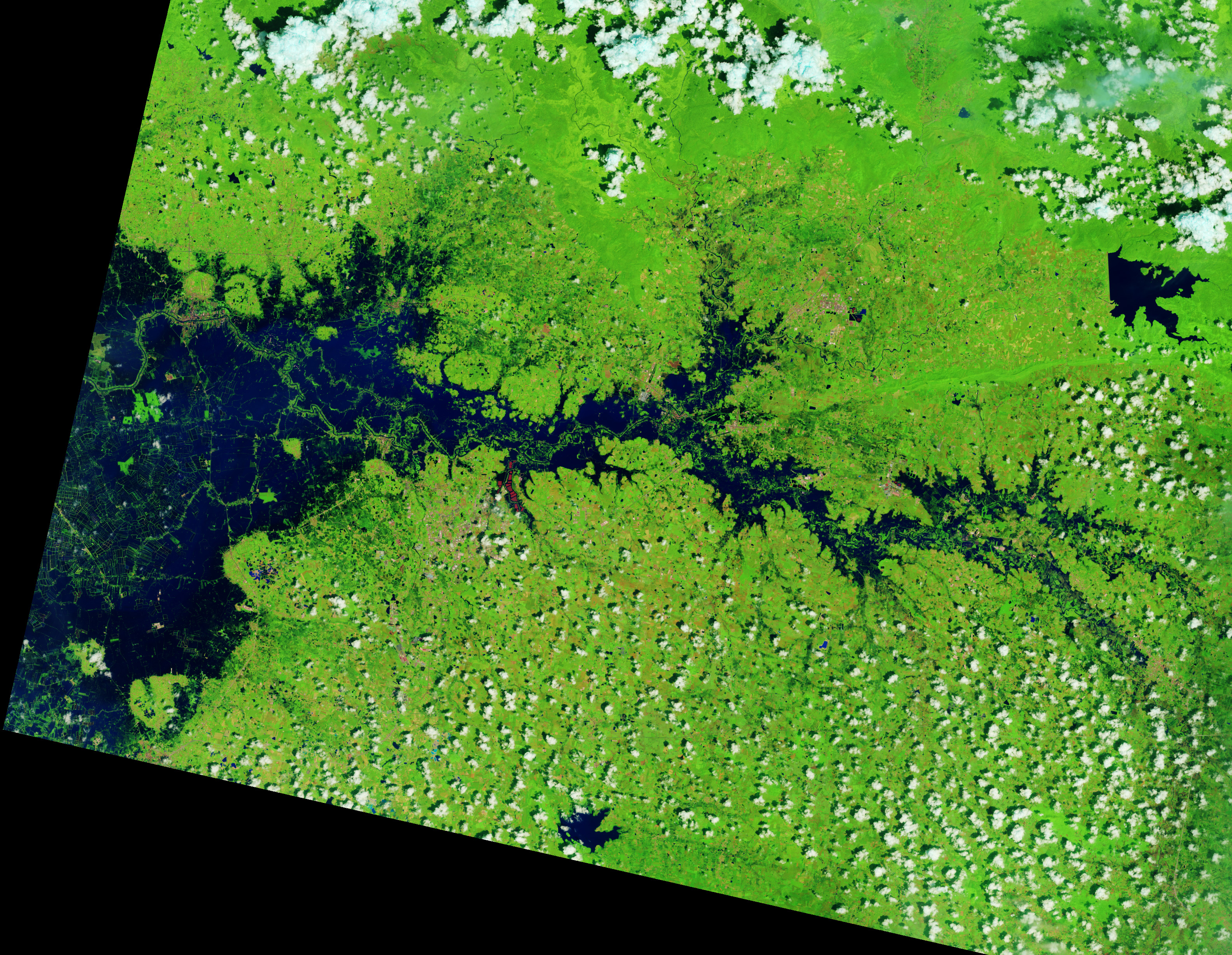
In a false-color satellite image of the same area, floodwaters (dark blue) flank a meandering river and cover a large swath of agricultural or aquacultural land primarily on the left side of the scene.
NASA Earth Observatory / Lauren Dauphin
October 7, 2025
October 2, 2026
September falls in the heart of the monsoon season in Thailand, where cities and towns are accustomed to the afternoon rains and thunderstorms that frequently roll through. But throughout late September and early October 2026, persistent heavy rains punctuated by intense downpours left low-lying areas across the country in Southeast Asia under sustained flooding.
Prachin Buri province was among the areas where flooding was widespread. The right image above shows land along the Bang Pakong River and nearby agricultural areas and aquaculture facilities inundated on October 2, 2026. The left image shows the same area at the same time of year in 2025. Acquired with NASA-USGS Landsat satellites, the images are false-color to better distinguish water from vegetation, developed land, and other surfaces. The bright red shapes are floating solar arrays.
Some of the flooding likely stemmed from a low-pressure system that stalled over the area for several days in late September. Stoked by moisture and energy from the warm Gulf of Thailand nearby, the system delivered especially intense rains to the region. About 100 kilometers (60 miles) to the west, Bangkok received nearly 300 millimeters (11.8 inches) of rain over a 48-hour period, according to news reports, close to the average monthly rainfall total for September of 344 millimeters (13.5 inches).
Since mid-September, flooding has occurred in 50 provinces across the country, affecting over 4 million people and causing dozens of deaths, according to the International Federation of Red Cross and Red Crescent Societies. Government agencies estimate about 270,000 hectares (670,000 acres) of farmland, including rice fields and fruit orchards, have been damaged.
NASA Earth Observatory images by Lauren Dauphin, using Landsat data from the U.S. Geological Survey. Story by Lindsey Doermann.
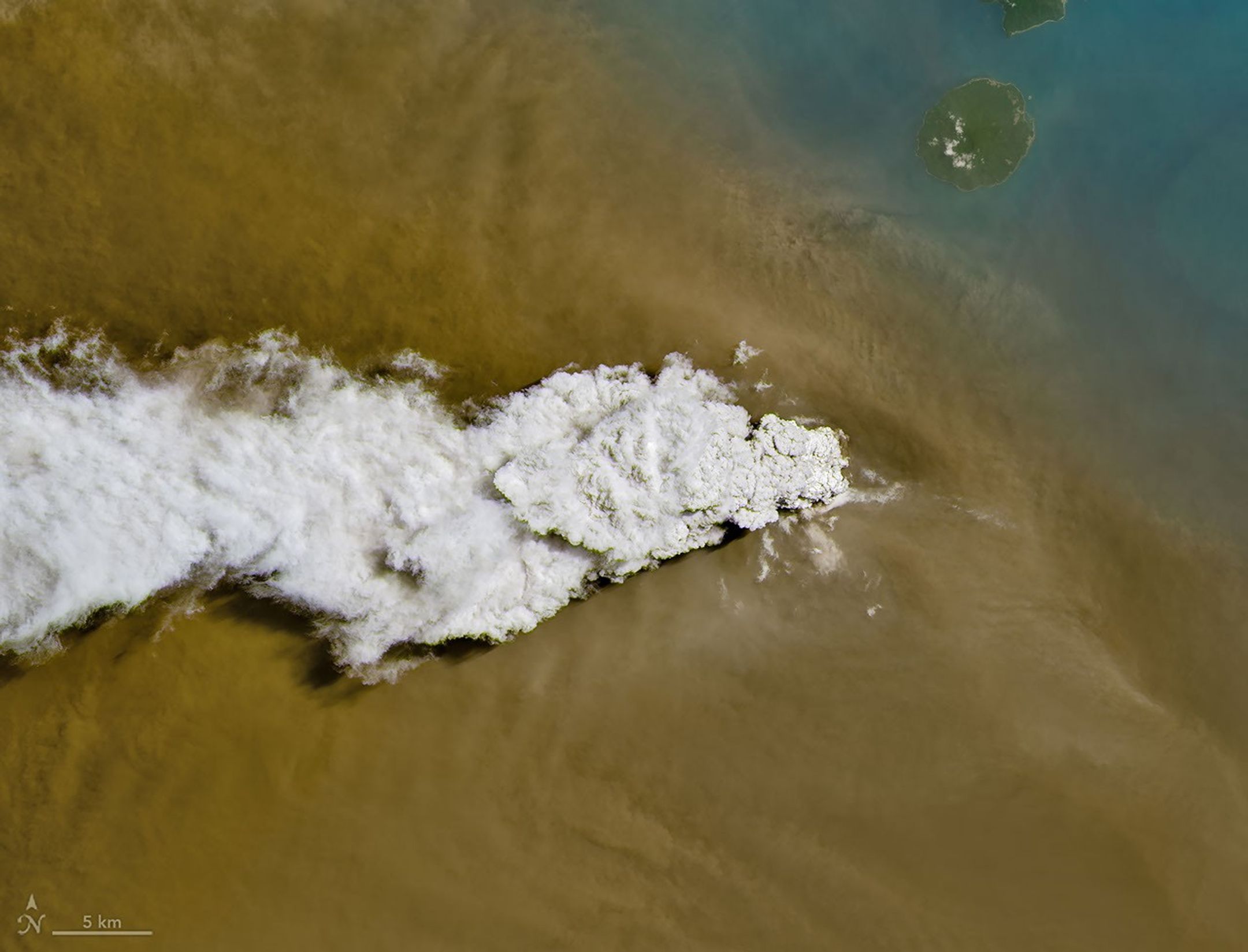
Anak Krakatau erupts ash and volcanic gases in this image acquired with the OLI (Operational Land Imager) on Landsat 8 on September 5, 2026.
NASA Earth Observatory/Michala Garrison
Eruptions are a regular occurrence at Anak Krakatau, a small volcano between the Indonesian islands of Java and Sumatra. Much of its activity remains relatively mild, but it occasionally puts on more impressive and hazardous shows of force. In early September 2026, a booming eruption lasting more than 24 hours sent gas and ash high into the atmosphere, disrupting thousands of flights and degrading air quality in parts of the country, including the capital city of Jakarta.
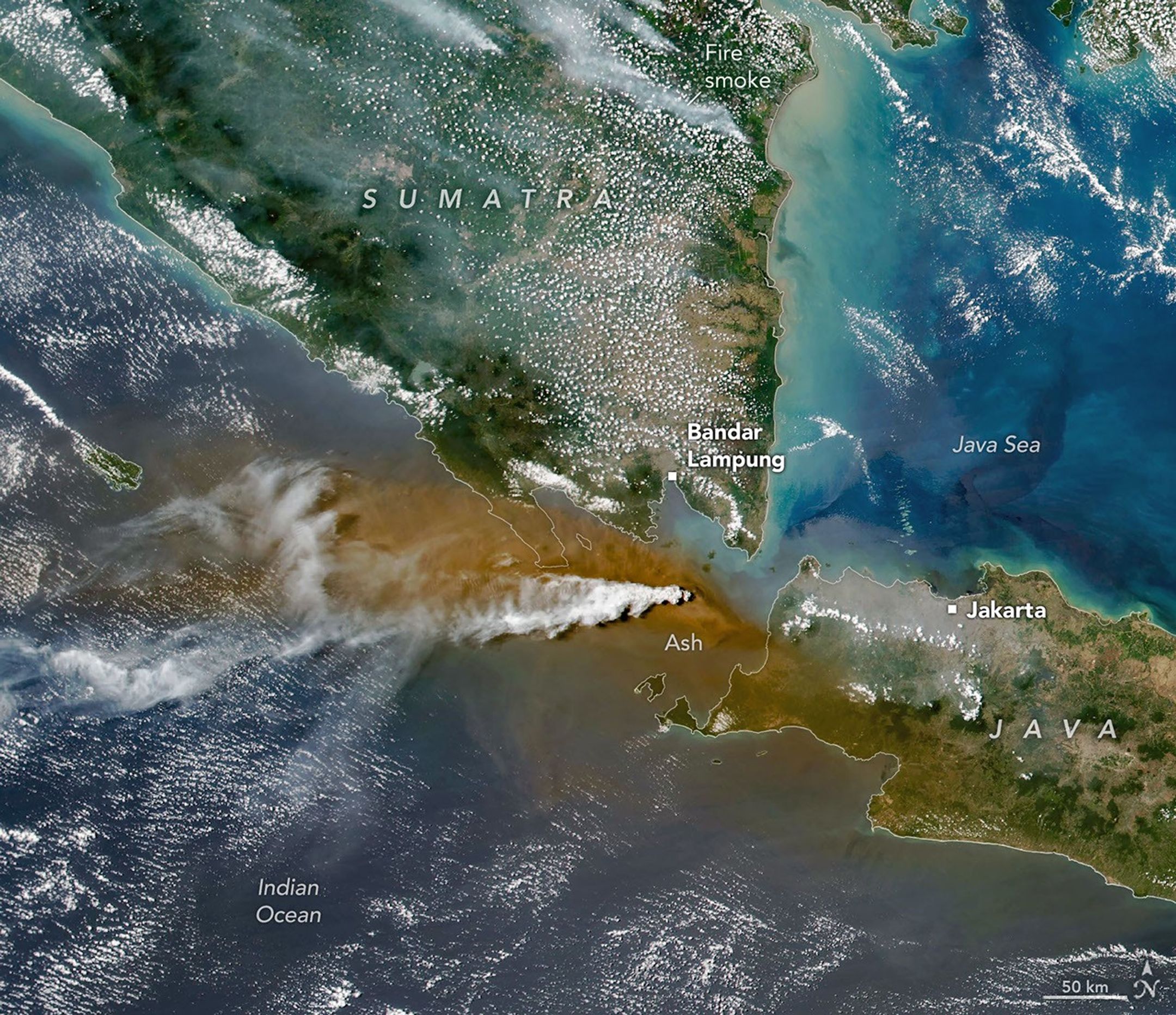
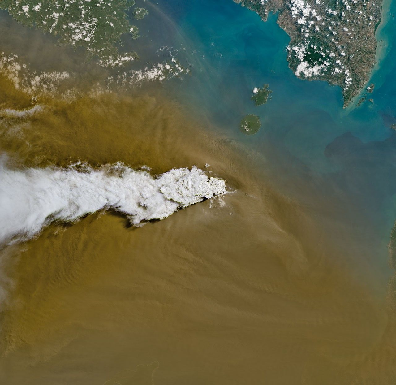
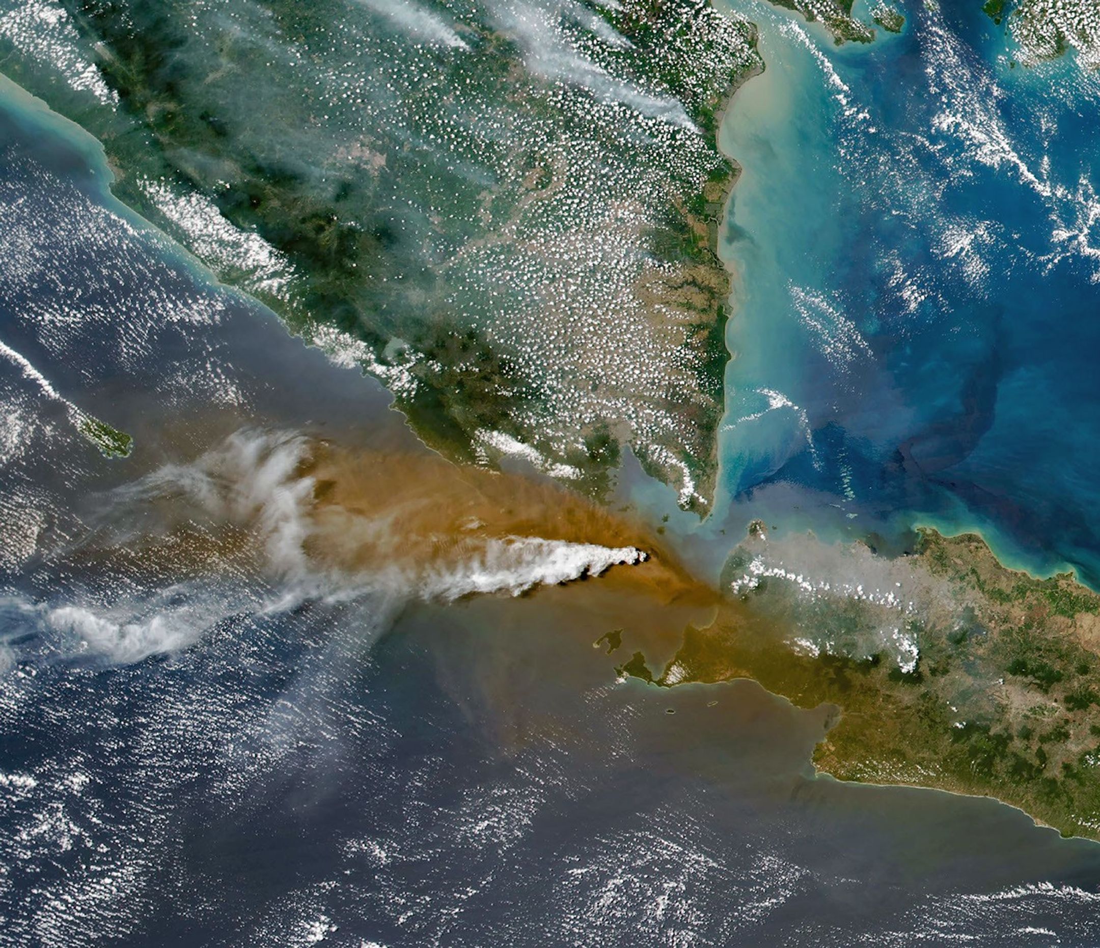
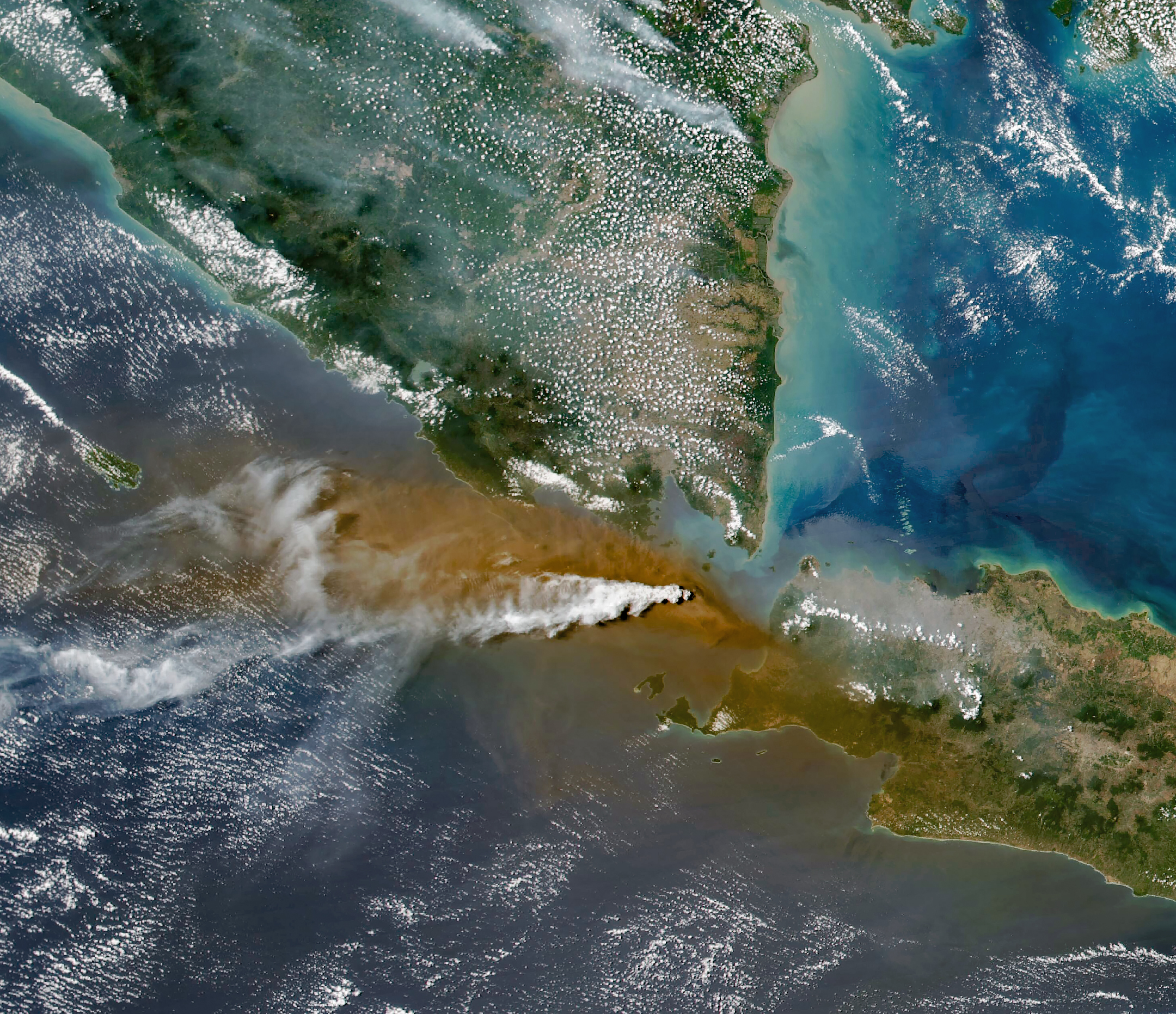
Satellites passing over the area during the eruption on September 5 captured images of the explosive activity. In the scene above, acquired with the OLI (Operational Land Imager) on the NASA-USGS Landsat 8 satellite, a white plume of volcanic gas billows over a brown ash cloud. Below, a wider view captured by the VIIRS (Visible Infrared Imaging Radiometer Suite) on the Suomi NPP satellite shows the volcanic material dispersing over a large area.
Indonesia’s meteorological agency reported that ash had reached altitudes up to 6,000 meters (20,000 feet) to the east of the volcano and 15,000 meters (50,000 feet) to the west by September 6. The presence of ash in the atmosphere prompted the temporary closure of eight airports on Java and Sumatra, disrupting nearly 3,000 flights in and out of the area, according to news reports.
Plumes of ash and volcanic gases from Anak Krakatau drift over Indonesia and the Indian Ocean in this image captured by the VIIRS (Visible Infrared Imaging Radiometer Suite) on the Suomi NPP satellite on September 5, 2026.
NASA Earth Observatory/Michala Garrison
Ashfall affected populated areas, particularly to the east of Anak Krakatau in Jakarta and other parts of West Java, the Indonesian Humanitarian Coordination Platform (IHCP) reported. Volcanic ash poses health risks to people and can irritate the respiratory tract, eyes, and skin. However, this air quality hazard differs from the smoke produced by peatland fires elsewhere in the country in terms of particle characteristics, dispersal patterns, and protection measures, the IHCP noted.
On September 6, the continuous explosive eruption from Anak Krakatau subsided, though the volcano kept rumbling. It returned to a more typical pattern of Strombolian eruptions, characterized by intermittent spurts of ash and volcanic material. Airports had resumed operation by September 8, but the volcano remained at the second-highest alert level on the country’s scale, as it has been since early July.
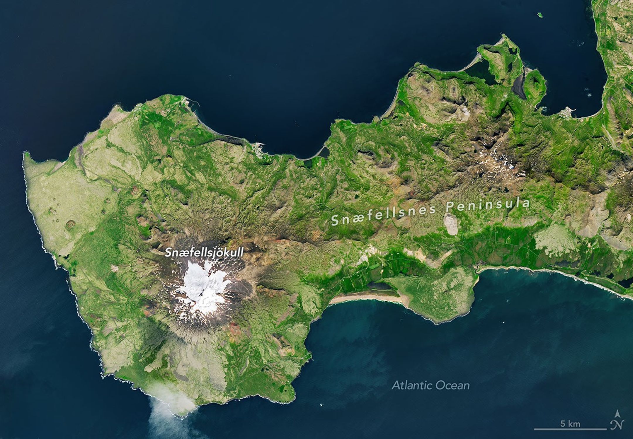
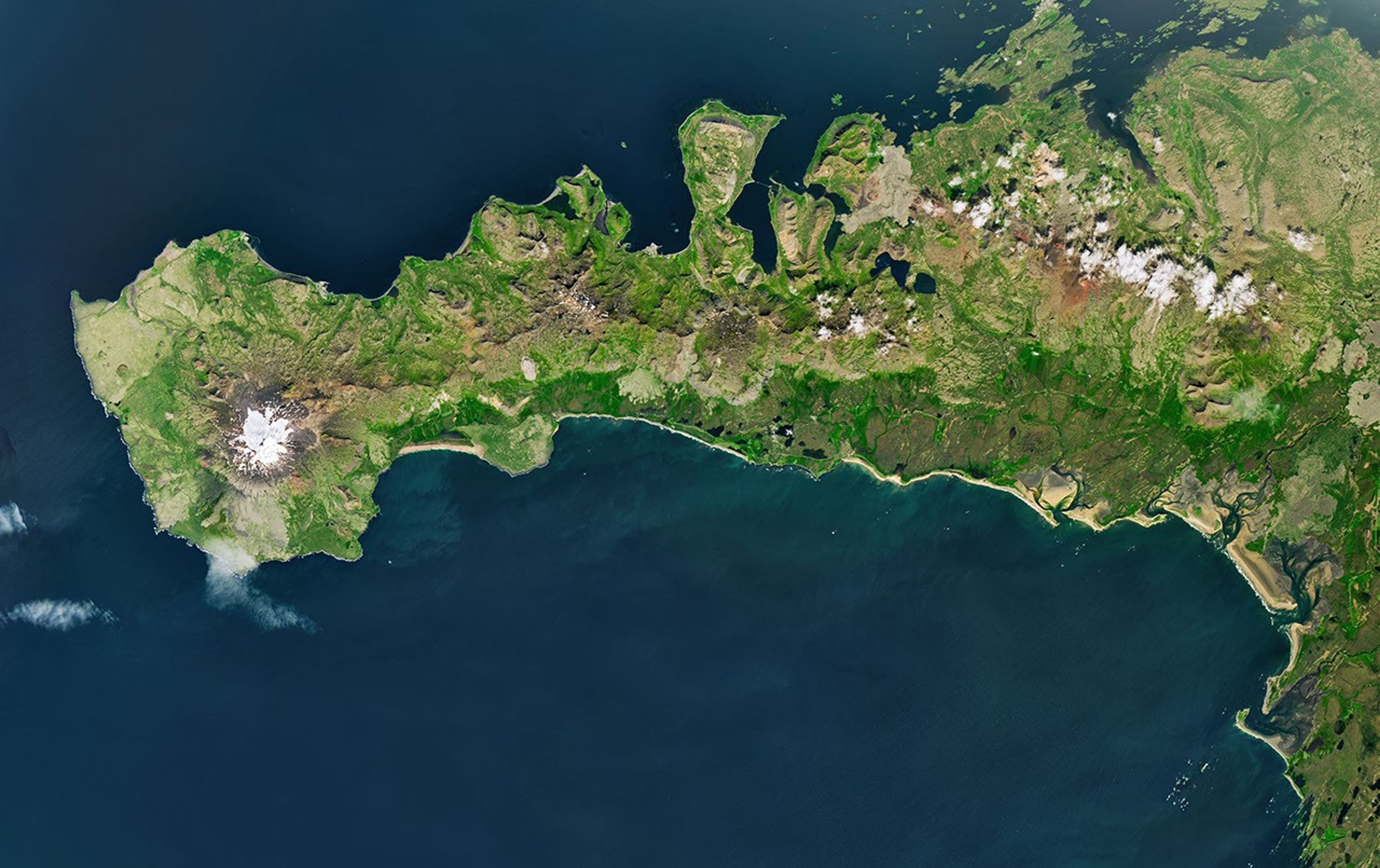
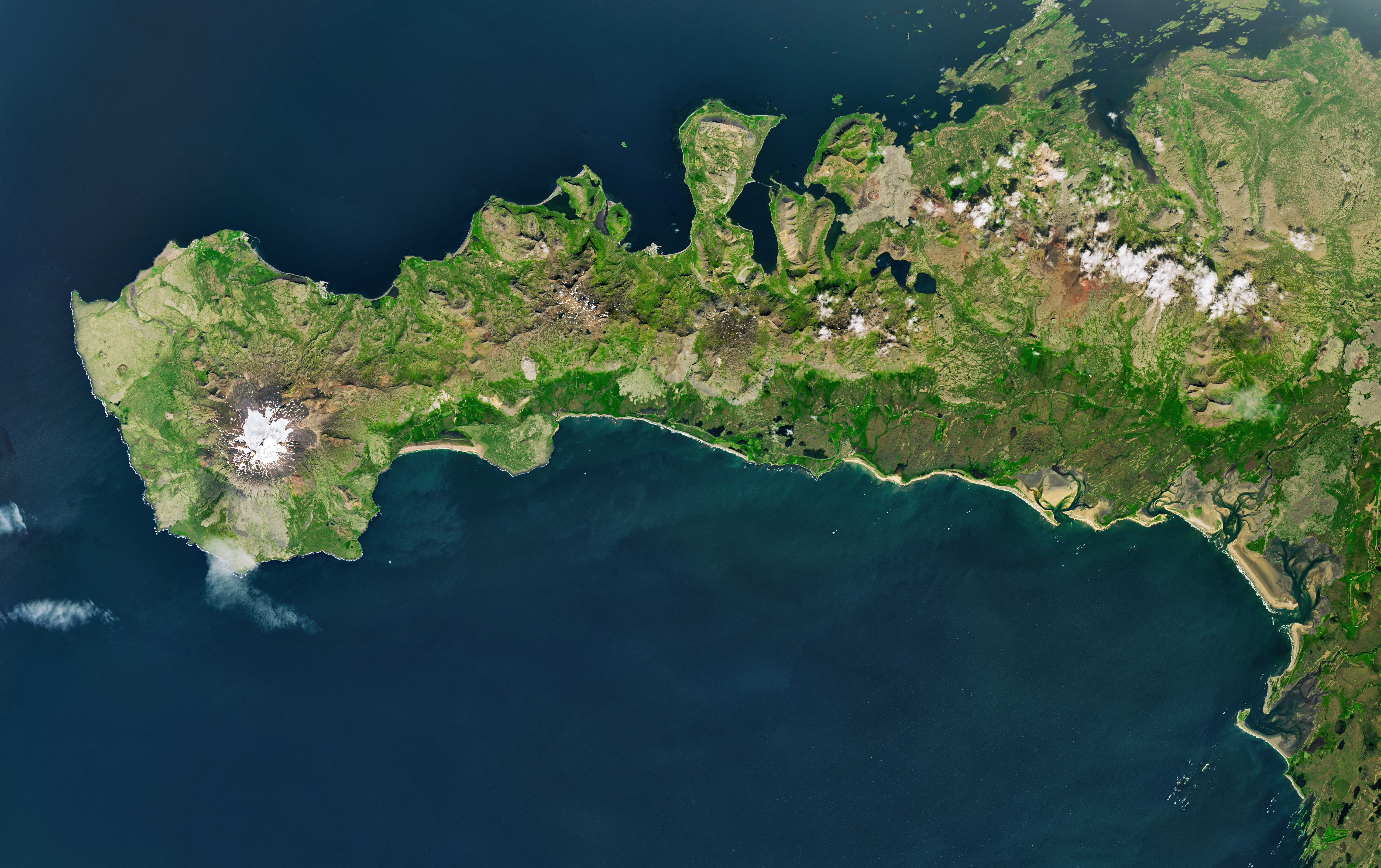
The glacier-capped Snæfellsjökull volcano is the defining feature of Iceland’s Snæfellsnes peninsula, shown in this image acquired with the OLI (Operational Land Imager) on Landsat 9 on July 25, 2026.
NASA Earth Observatory/Michala Garrison
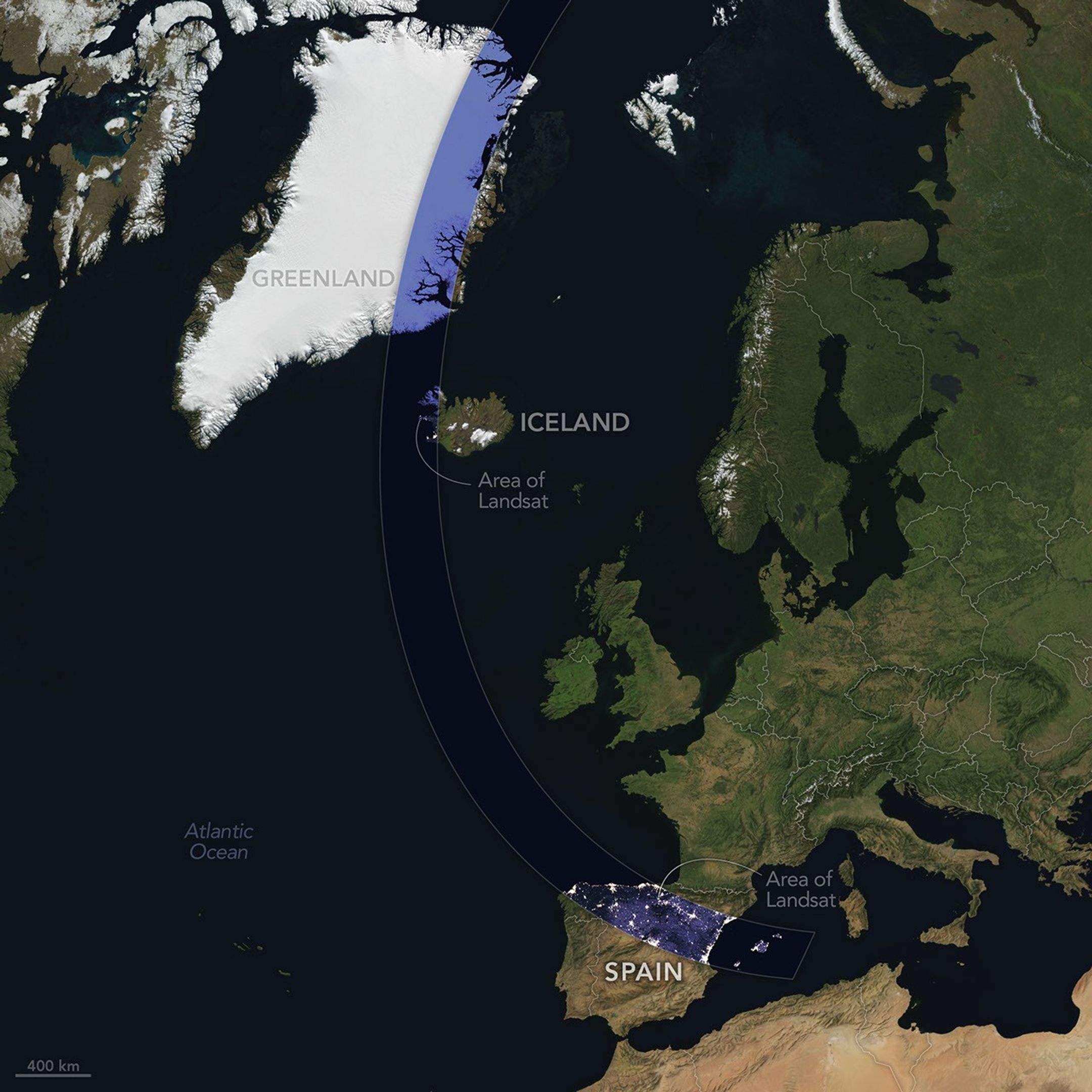
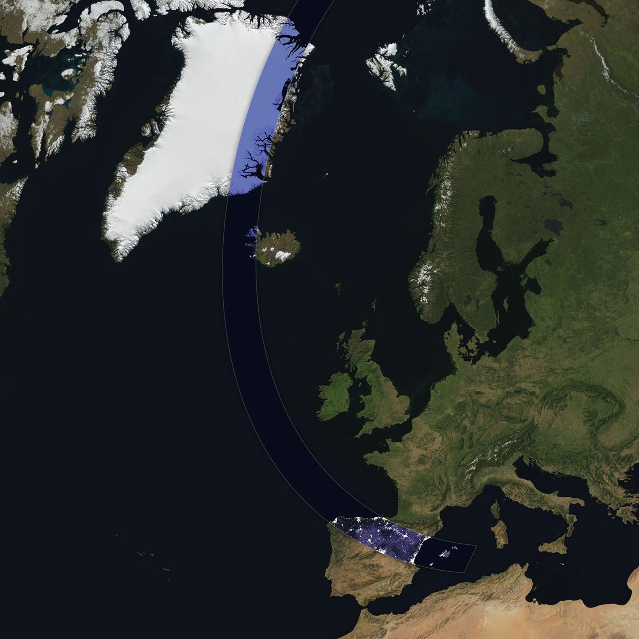
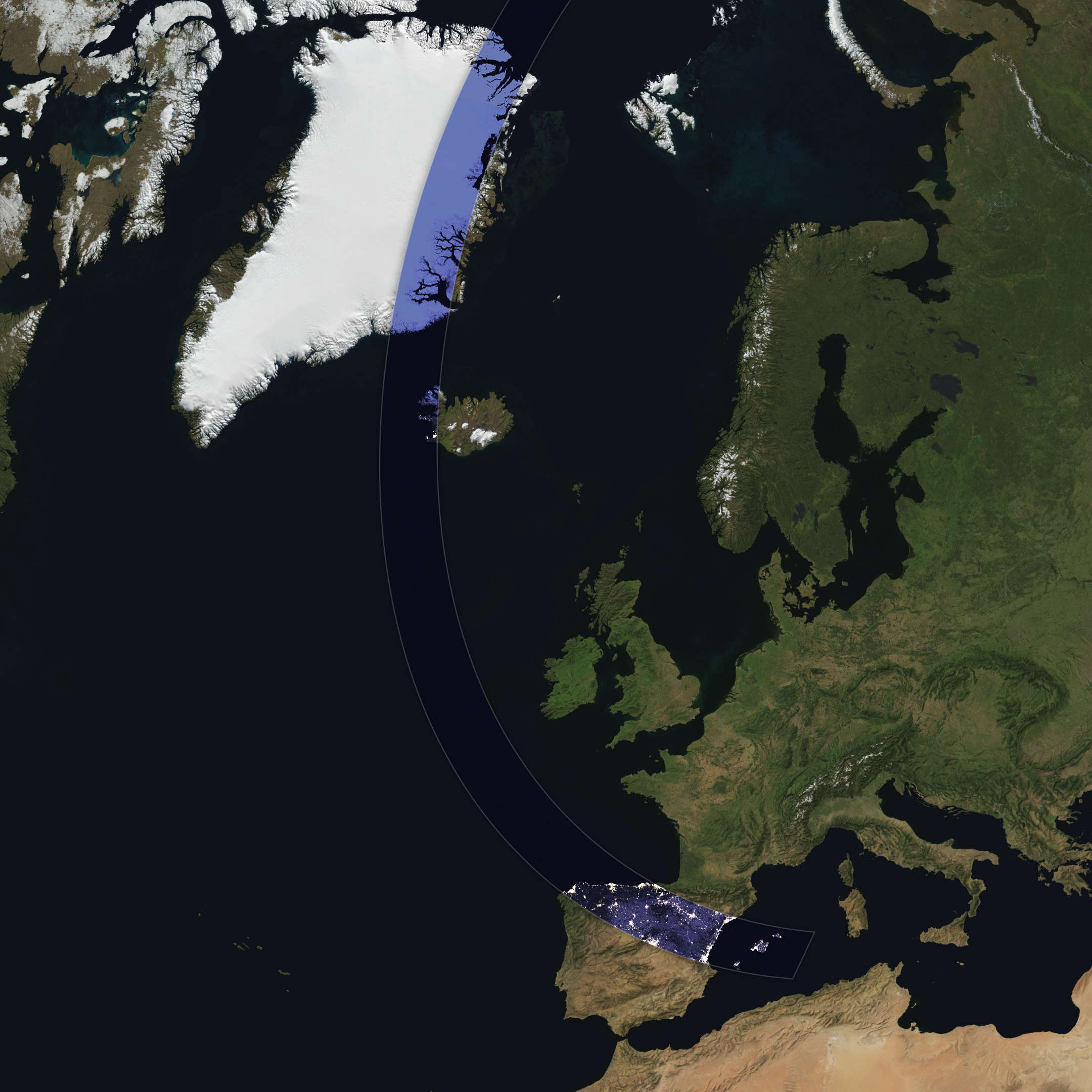
The Sun, Moon, and Earth align on August 12, 2026, to produce a total solar eclipse. When this celestial event last occurred, on April 8, 2024, the path of totality stretched across North America, giving millions the chance to glimpse the Sun’s corona. In 2026, the viewing locales are more limited; only a handful of land areas in the Northern Hemisphere, including parts of Iceland and Spain, fall within the path of totality.
On August 12, the Moon’s shadow will first cross over the Arctic Circle from northern Russia and then track along the eastern side of Greenland. At about 5:45 p.m. local time in Iceland (17:45 Universal Time), the country’s western fringes—including the Snæfellsnes peninsula, shown in the Landsat image above—will begin to experience totality. The greatest eclipse will occur near this sparsely populated peninsula when the Moon appears the largest and covers more of the Sun.
The path of totality of the solar eclipse on August 12, 2026, spans Greenland, Iceland, and Spain. The base imagery for the map comes from Blue Marble: Next Generation, with data from Black Marble shown in the path of totality. Blue Marble is built from scenes captured by MODIS (Moderate Resolution Imaging Spectroradiometer), while Black Marble is based on observations by the VIIRS (Visible Infrared Imaging Radiometer Suite) day-night band.
NASA Earth Observatory/Michala Garrison
The Snæfellsjökull volcano on the western end of the peninsula is covered in ice and last erupted about 1,800 years ago. It is the highlight of a national park of the same name, where people are expected to visit to view the eclipse. The stratovolcano even has a literary claim to fame: in Jules Verne’s A Journey to the Center of the Earth, characters venture underground through its crater, later emerging in an eruption of Stromboli, in Italy. In 2025, a broader area of the peninsula was designated a UNESCO biosphere reserve, containing over 70 percent of Iceland’s flora and an agglomeration of volcanic landscapes, wetlands, and grasslands.
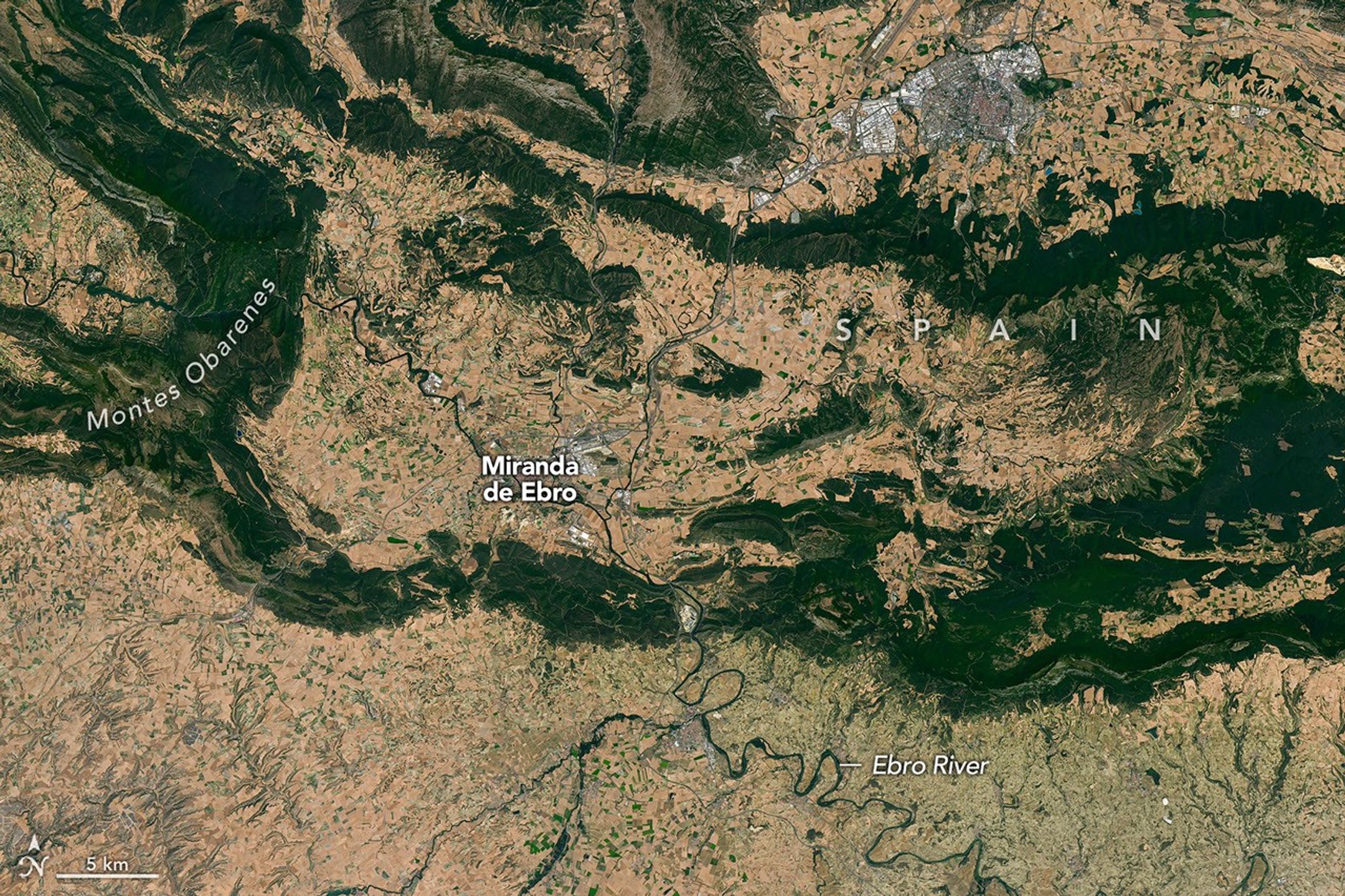
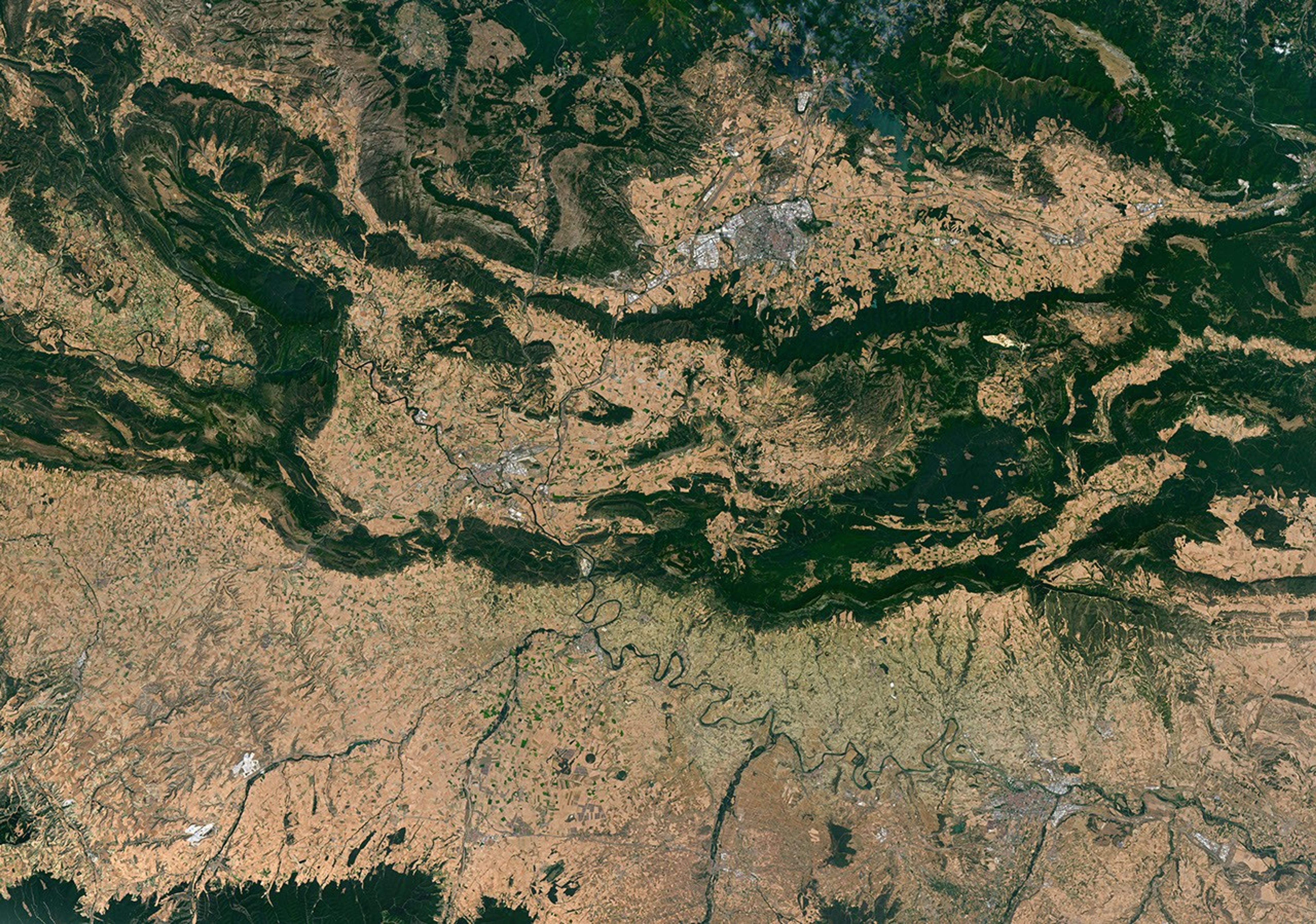
From Iceland, the eclipse shadow, or umbra, progresses across the North Atlantic and reaches northern Spain shortly before sunset. It runs east-southeast across the country, much like the Ebro River (Río Ebro), seen in the Landsat image below.
The Ebro River, meandering across northern Spain in this image acquired with the OLI (Operational Land Imager) on Landsat 8 on July 21, 2026, is in the path of totality of the August 2026 solar eclipse.
NASA Earth Observatory/Michala Garrison
The upper Ebro emerges from rugged terrain in Parque Natural de Montes Obarenes-San Zadornil, where it carves canyons and gorges through the eastern foothills of the Cantabrian Mountains. It then meanders through La Rioja, a region known for its vineyards. About 400 kilometers (250 miles) away, the river reaches a delta on the Mediterranean coast between Barcelona and Valencia.
Based on satellite measurements of cloud cover in August over several decades, viewers in Spain have a higher likelihood than those in Iceland of getting a clear look at the eclipse. And despite limited viewing opportunities in the path of totality, the rest of Europe, parts of Africa, Canada, and the northern and northeastern U.S. will experience a partial eclipse.
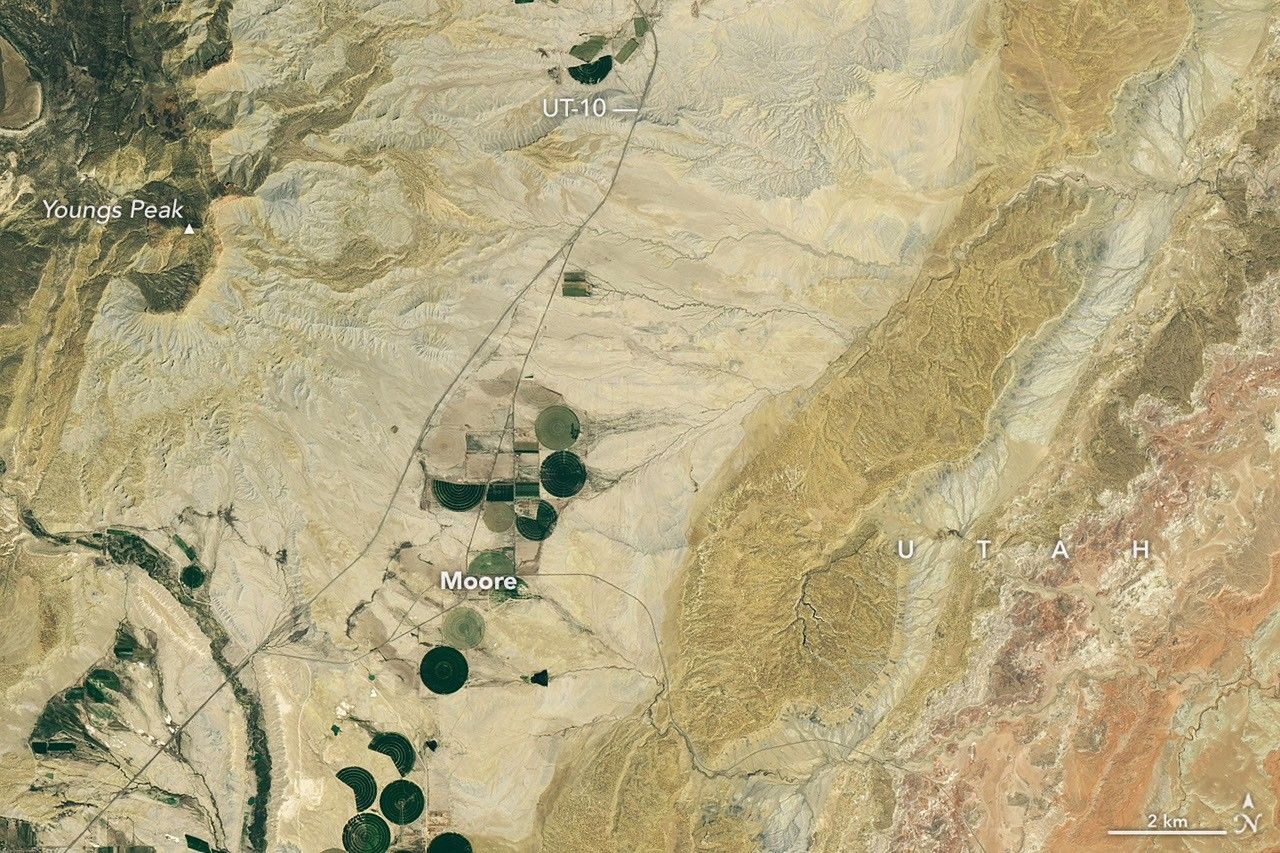
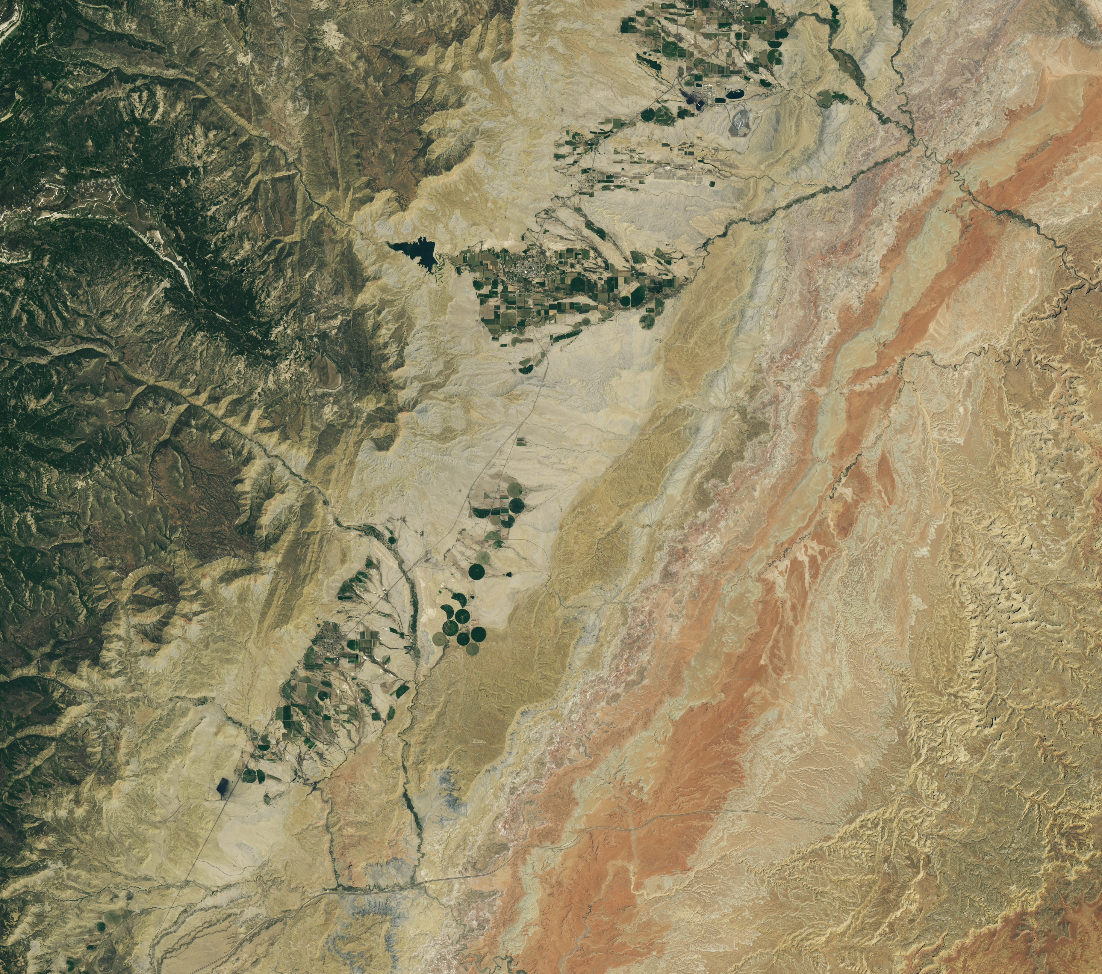
A dry, tan-colored valley containing a few circular irrigated fields runs roughly north-south through the image.
NASA Earth Observatory / Lauren Dauphin
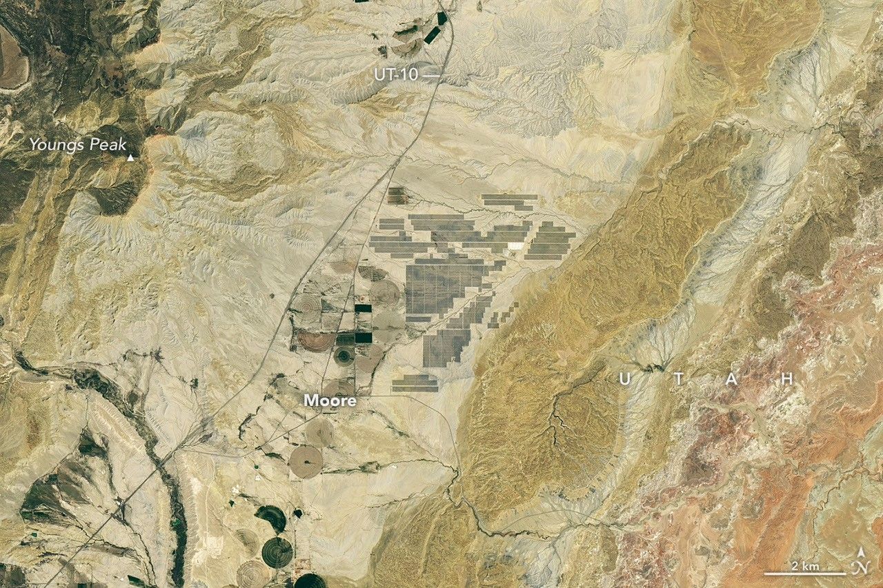
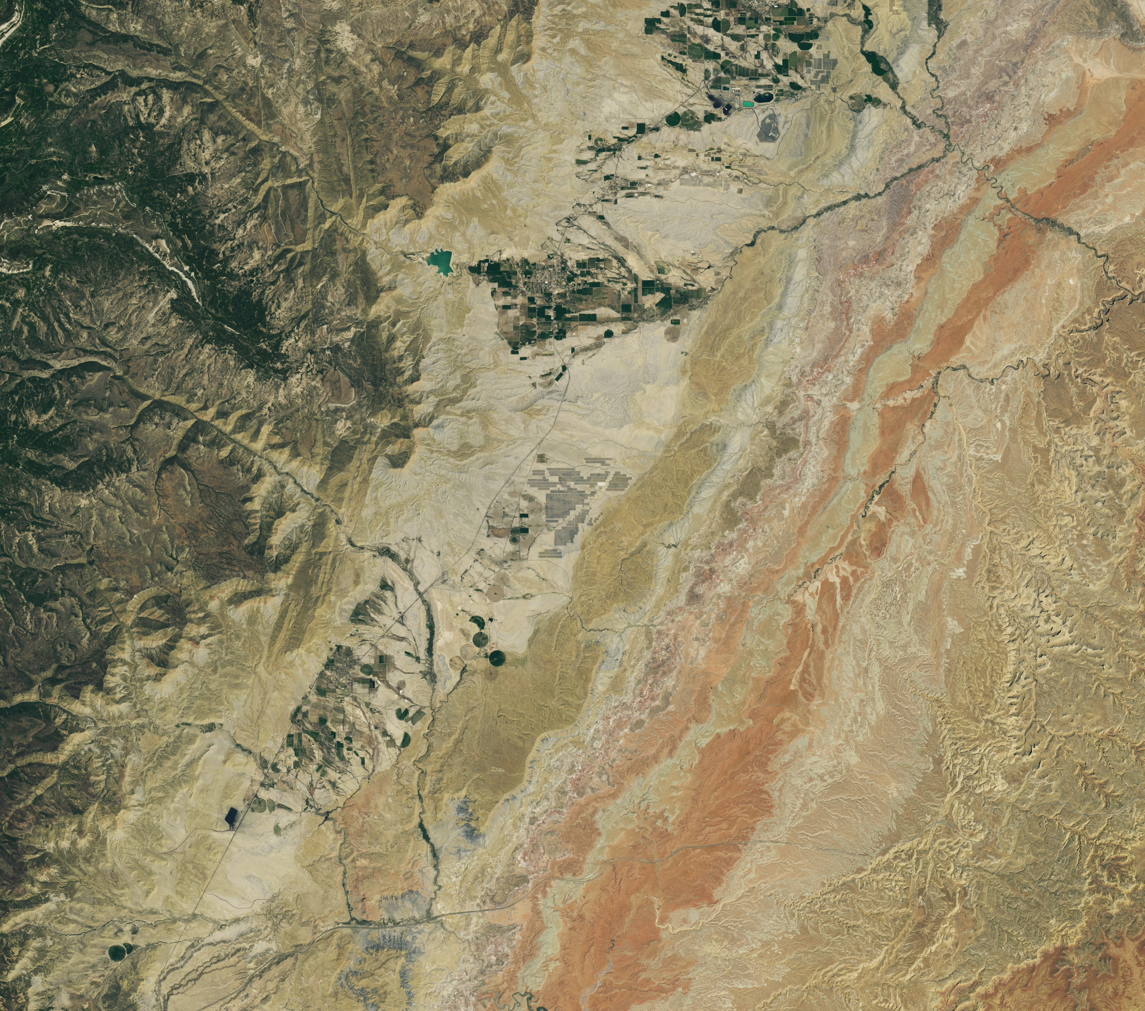
Grid-like arrays of solar panels cover parts of a valley floor in a brown, dry-looking area of Utah.
NASA Earth Observatory / Lauren Dauphin
A dry, tan-colored valley containing a few circular irrigated fields runs roughly north-south through the image.
NASA Earth Observatory / Lauren Dauphin
Grid-like arrays of solar panels cover parts of a valley floor in a brown, dry-looking area of Utah.
NASA Earth Observatory / Lauren Dauphin
June 16, 2024
June 6, 2026
The nearly one million photovoltaic panels of a solar energy and battery storage facility in Utah appear in the right image, acquired with the OLI (Operational Land Imager) on Landsat 8 on June 6, 2026. The same sensor captured the left image on June 16, 2024. NASA Earth Observatory images by Lauren Dauphin.
Historically, central Utah’s Castle Valley has been a coal hub, with mining operations on the slopes of the Wasatch Plateau to the west active since the late 1800s. A different energy development arrived in the region in June 2026, when a large solar power and battery storage plant came online in the sunny valley about 130 miles (210 kilometers) southeast of Salt Lake City.
The recently constructed Green River Energy Center, seen in the Landsat 8 image above (right), features nearly one million solar panels and roughly 500 batteries on several square miles of previously undeveloped land. The facility has 400 megawatts of solar-generating capacity with another 400 megawatts of battery storage. That places it among the many utility-scale solar power and battery storage projects that the U.S. Energy Information Administration expects to be plugged into the country’s grid in 2026.
The Utah facility is slated to supply power to Salt Lake City and other areas across the state, according to news reports, and project staff estimate it could produce enough electricity for more than 100,000 homes. With its integrated battery storage, the plant has the potential to generate power at all hours, even when the Sun isn’t shining. And the Green River Energy Center can build on Castle Valley’s energy legacy by utilizing existing transmission lines originally built for coal-fired power plants in the area.
Though Utah adopted coal as its state rock and has long relied on it for energy, other sources, such as solar and geothermal, are becoming larger parts of the state’s energy mix. In 2025, coal fueled about half of the state’s electricity generation, down from about 75 percent in 2015. Meanwhile, solar grew to account for about 14 percent of generation in 2025, up from nearly zero a decade before. Satellite data can be useful to planners and policymakers involved in energy transitions for assessing the potential of renewable energy systems and tracking their adoption and performance.
NASA Earth Observatory images by Lauren Dauphin, using Landsat data from the U.S. Geological Survey. Story by Lindsey Doermann.
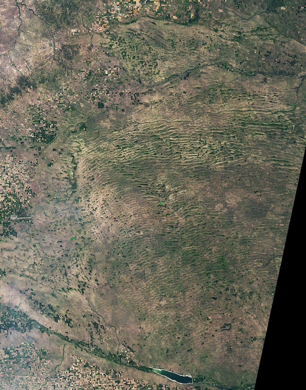
The Nebraska Sandhills stretch across the north-central part of the state in this image acquired on August 19, 2025, with the OLI (Operational Land Imager) on Landsat 8.
NASA Earth Observatory/Lauren Dauphin
Editor’s Note: Today’s story is the answer to the June Puzzler.
The undulating landscape of north-central Nebraska may be easy to overlook among the iconic dune fields of the world. Far from any coast or desert, the Nebraska Sandhills—comprising the Western Hemisphere’s largest system of sand dunes—bring their own brand of beauty and value. Grasslands blanket the rolling hills, providing grazing grounds for livestock, while lakes and wetlands dot the landscape, supporting diverse plant and animal life.
Much of the sand forming the hills originated in the Rocky Mountains. Rivers carried the eroded material down from the mountains and deposited it across the Great Plains during the Pleistocene. In times of drought, winds blowing predominantly from the north or south lofted sand out of dried riverbeds, gradually building and shaping dunes. About 3,500 years ago, grassland vegetation stabilized the features. Today, the rippled pattern spans about 20,000 square miles (52,000 square kilometers), about one-quarter of the state of Nebraska.
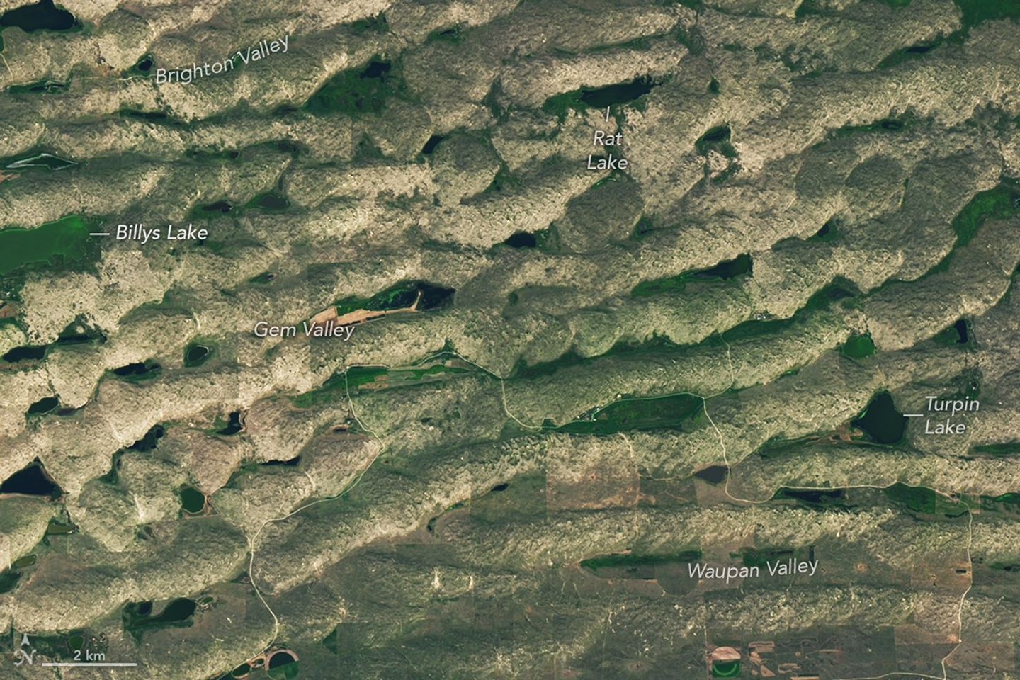
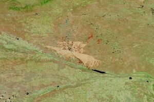
Some of the largest, grassland-covered dunes in the Nebraska Sandhills are found in the northwestern part of the region, shown in this image acquired on August 19, 2025, with the OLI (Operational Land Imager) on Landsat 8.
NASA Earth Observatory/Lauren Dauphin
Some of the largest dunes occur in and around the area shown in the detailed image above, near the northern edge of the Sandhills region. These transverse dunes stand as high as 400 feet (120 meters) and extend for several miles. Their northern slopes are gentler than their southern slopes, reflecting the dominant influence of northerly winds. In other areas, dunes are more symmetric, suggesting that winds blew with nearly equal strength from the north and south, alternating with the seasons.
The grasslands that now cover the hills constitute pastureland for grazing livestock. Ranching expanded significantly in the area after passage of the Kinkaid Act in 1904, which allotted 640-acre parcels of land to ranchers who would settle it. Today, far more cattle than humans occupy the region, and half of Nebraska’s nearly 23 million acres of rangeland and pastureland are in the Sandhills. Some ranchers graze their cattle in patterns meant to approximate the large bison herds that once roamed the land.
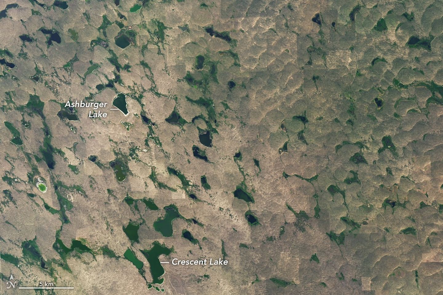
Lakes and wetlands fill the valleys between dunes in Crescent Lake National Wildlife Refuge, shown in this image acquired on August 19, 2025, with the OLI (Operational Land Imager) on Landsat 8.
NASA Earth Observatory/Lauren Dauphin
Though much of the land in the Sandhills is privately owned, some is set aside in protected public lands. One of these areas, Crescent Lake National Wildlife Refuge on the southwestern edge of the Sandhills region, is shown above. Wetlands, including shallow lakes, marshes, and wet meadows, fill some of the valleys between the dunes. The land here is sponge-like, with precipitation seeping down through the soil and recharging groundwater instead of flowing off through stream channels.
Located along the Central Flyway, the refuge is a haven for migratory birds, and dozens of species of waterfowl, marsh birds, and shorebirds utilize the area. Among other wildlife, several types of turtles thrive in the ponds and prairies. Wetlands across the Sandhills support rare species such as the whooping crane, western prairie fringed orchid, and Topeka shiner.
NASA Earth Observatory images by Lauren Dauphin, using Landsat data from the U.S. Geological Survey. Story by Lindsey Doermann.
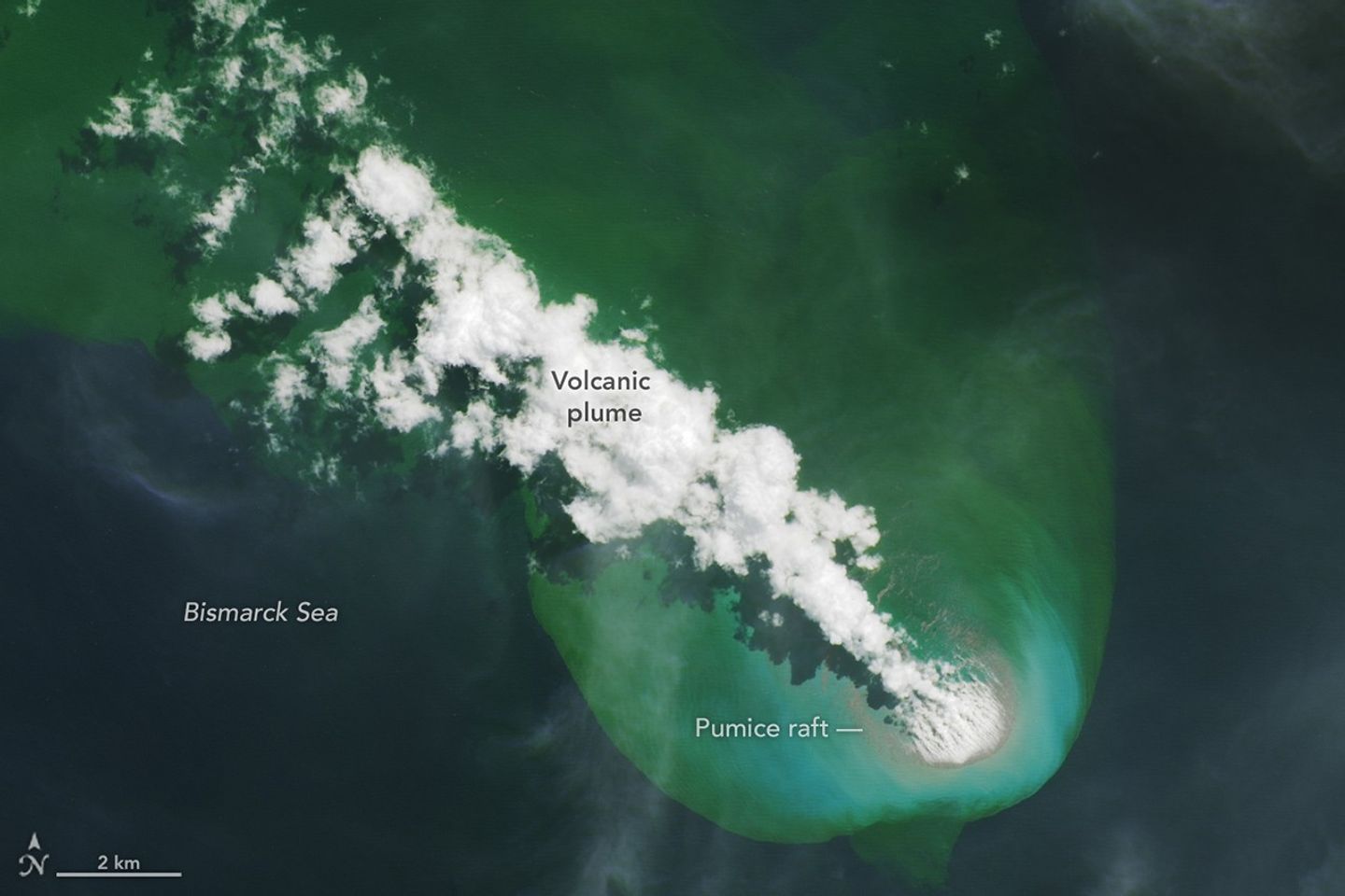
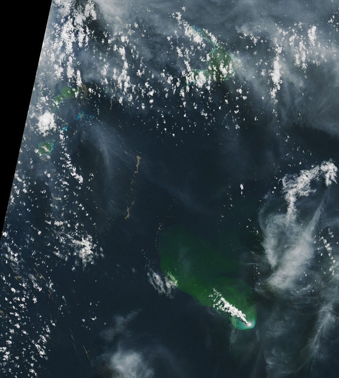
On May 8, 2026, satellites detected signs of an unexpected submarine volcanic eruption in the Bismarck Sea near the islands of Papua New Guinea. Over the next several weeks, plumes of steam and ash streamed over the sea, and areas of discolored water surrounded the eruption site. Relatively little is known about the ocean floor in this area or the volcanic feature that is presently erupting. But experts think the new activity, ongoing as of mid-June, might be occurring along the Titan Ridge and has the potential to form an ephemeral new island.
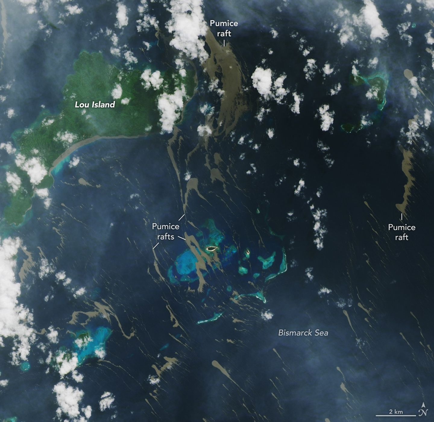
Despite the unknowns, the effects of the eruption became unmistakable for some communities in Papua New Guinea’s Admiralty Islands. In early June, rafts of pumice drifted northwest from the eruption site and clogged up coastlines on several of the islands. Bands of the buoyant volcanic material are visible in this image, acquired with the OLI (Operational Land Imager) on Landsat 8 on June 4, as they drifted with surface currents on the Bismarck Sea.
Several days after the image, news outlets reported acute impacts from thick masses of pumice reaching coastal areas. Communities on Lou Island and Baluan Island, to the south, were described by officials as among the worst affected, according to reports from local media. Outlets reported that a layer of pumice up to several meters thick blanketed the shore, cutting off access to the water. The volcanic fragments similarly choked the coast and key waterways around the much larger Manus Island, about 125 kilometers (80 miles) northwest of the volcano and out of frame.
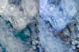
A submarine volcano produces a plume of discolored water and vents steam into the air in an image acquired on June 4, 2026, with the OLI (Operational Land Imager) on Landsat 8. Pumice is visible near the base of the plume and exhibits a thermal signature in infrared imagery.
NASA Earth Observatory/Lauren Dauphin
Studies of past pumice raft events have found that the material can remain afloat for months to years before sinking out of satellite view. Larger rafts can form with the help of ash, which serves to “weld” together fragments of the porous rock, said Jim Garvin, the chief scientist at NASA’s Goddard Space Flight Center, noting this process occurred during the 2022 eruption of Hunga Tonga-Hunga Ha‘apai. “These masses can pile up around erupting vents to protect the eruption centers and produce ephemeral new lands in some cases,” he said. When adrift, such pumice platforms can act as floating homes for marine organisms—from microalgae to bryozoans to barnacles—and enable them to disperse over long distances.
Though beneficial to life in some ways, the rafts can pose serious threats to humans and other species. Some of the larger fragments of pumice stack up to form ridges when they reach the coastlines of islands. Reports from Papua New Guinea highlight the disruptions to fishing, the transport of goods, and access to critical services that can occur when pumice accumulates along the coast.
Communities have expressed concerns over the pumice’s effects on marine ecosystems, as well. Researchers have noted that the sustained presence of pumice can block sunlight and may inhibit photosynthesis in seagrass and corals below, and the rocks may physically damage reef structures. In a review of the ecological effects of pumice reaching Japan’s coast in 2021, researchers noted the die-off of filter-feeding fish in fishery cages from ingesting pumice, warning that other wildlife may be harmed by mistakenly consuming the rocks.
New studies using an ensemble of orbital remote sensing platforms—including Landsat, hyperspectral instruments, and imaging radars—are tracking developments in this Bismarck Sea region, Garvin said. These observations can provide new perspectives on hazards as well as unique scientific opportunities for improved understanding of submarine eruptions.
NASA Earth Observatory images by Lauren Dauphin, using Landsat data from the U.S. Geological Survey. Story by Lindsey Doermann.
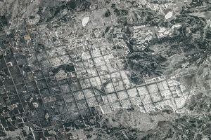
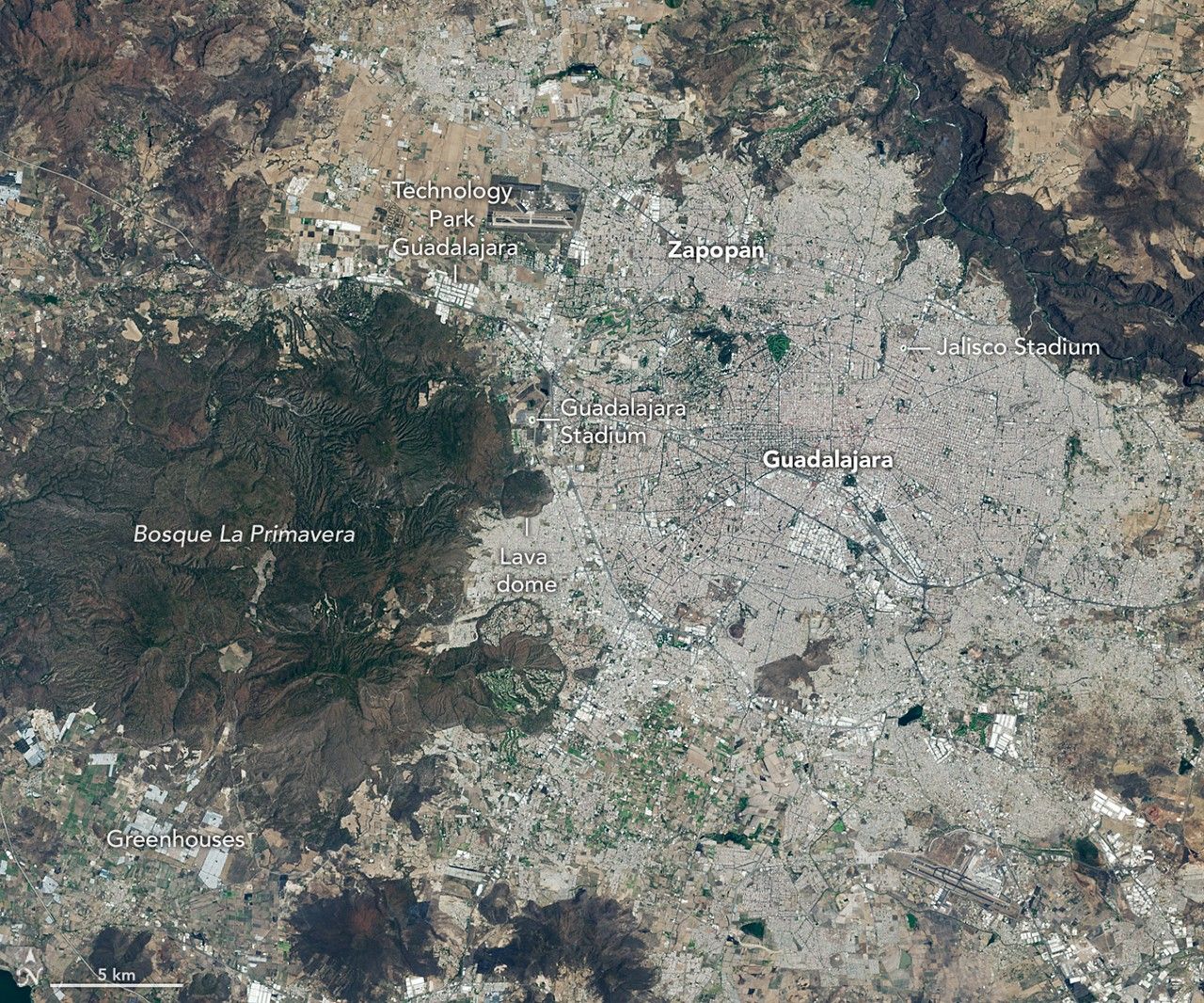
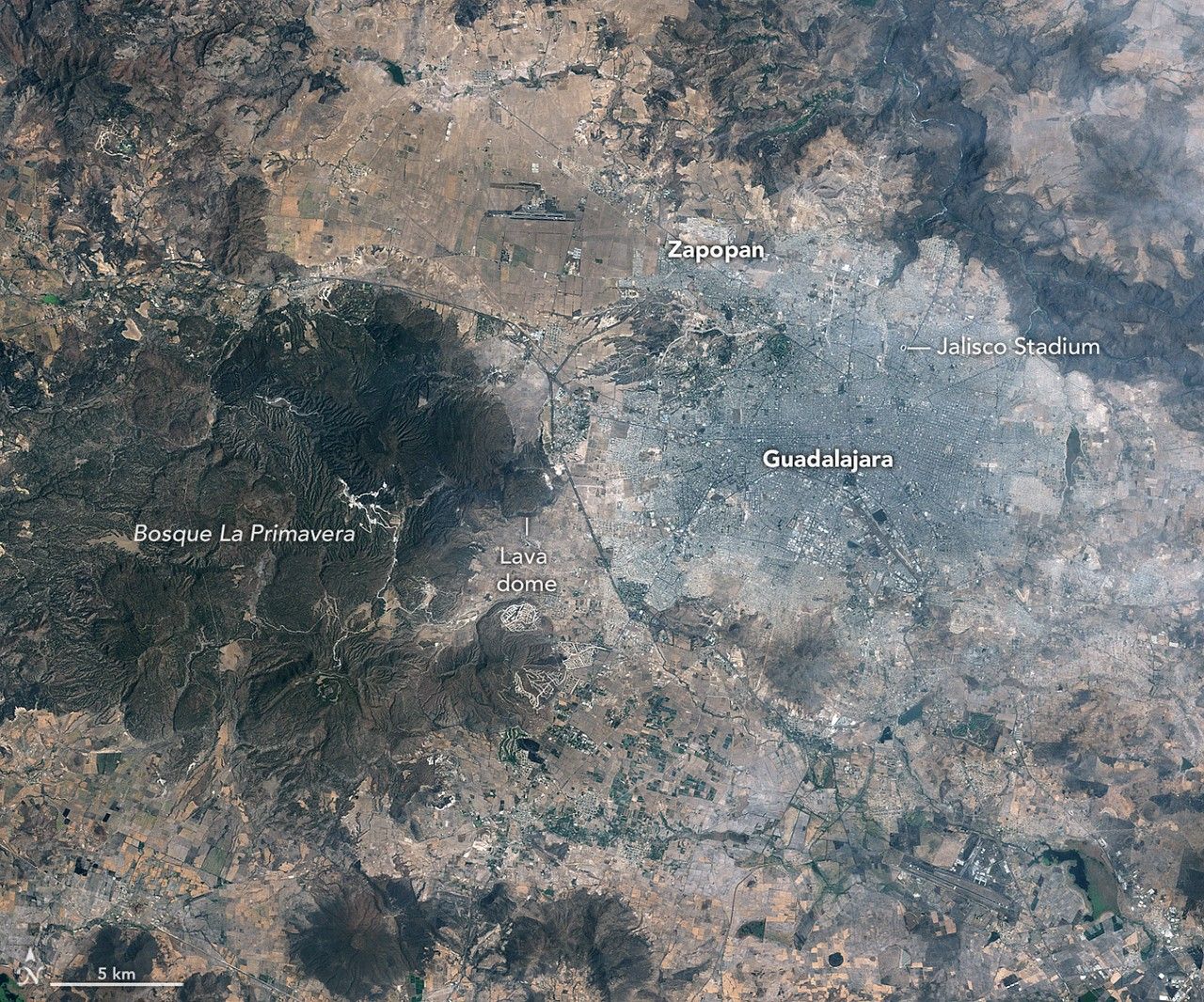
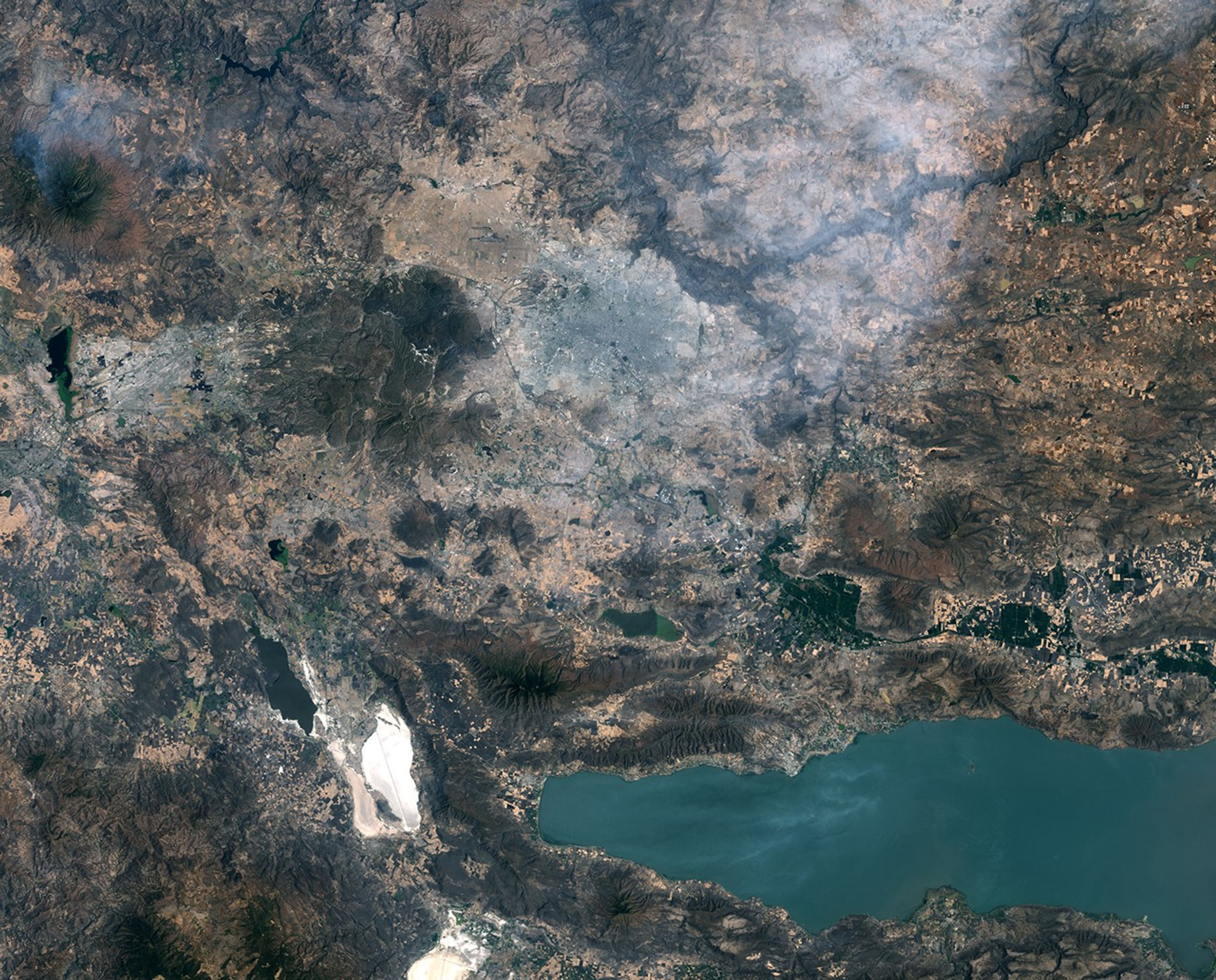
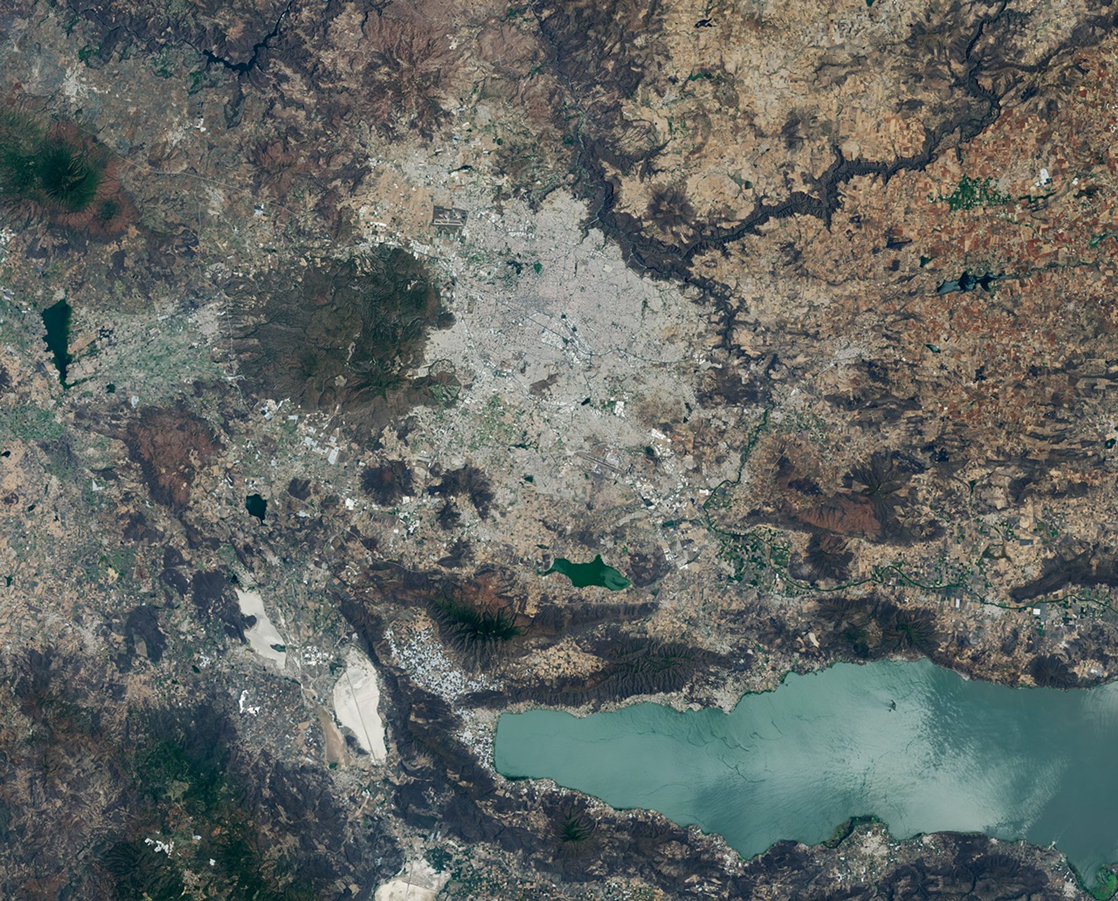
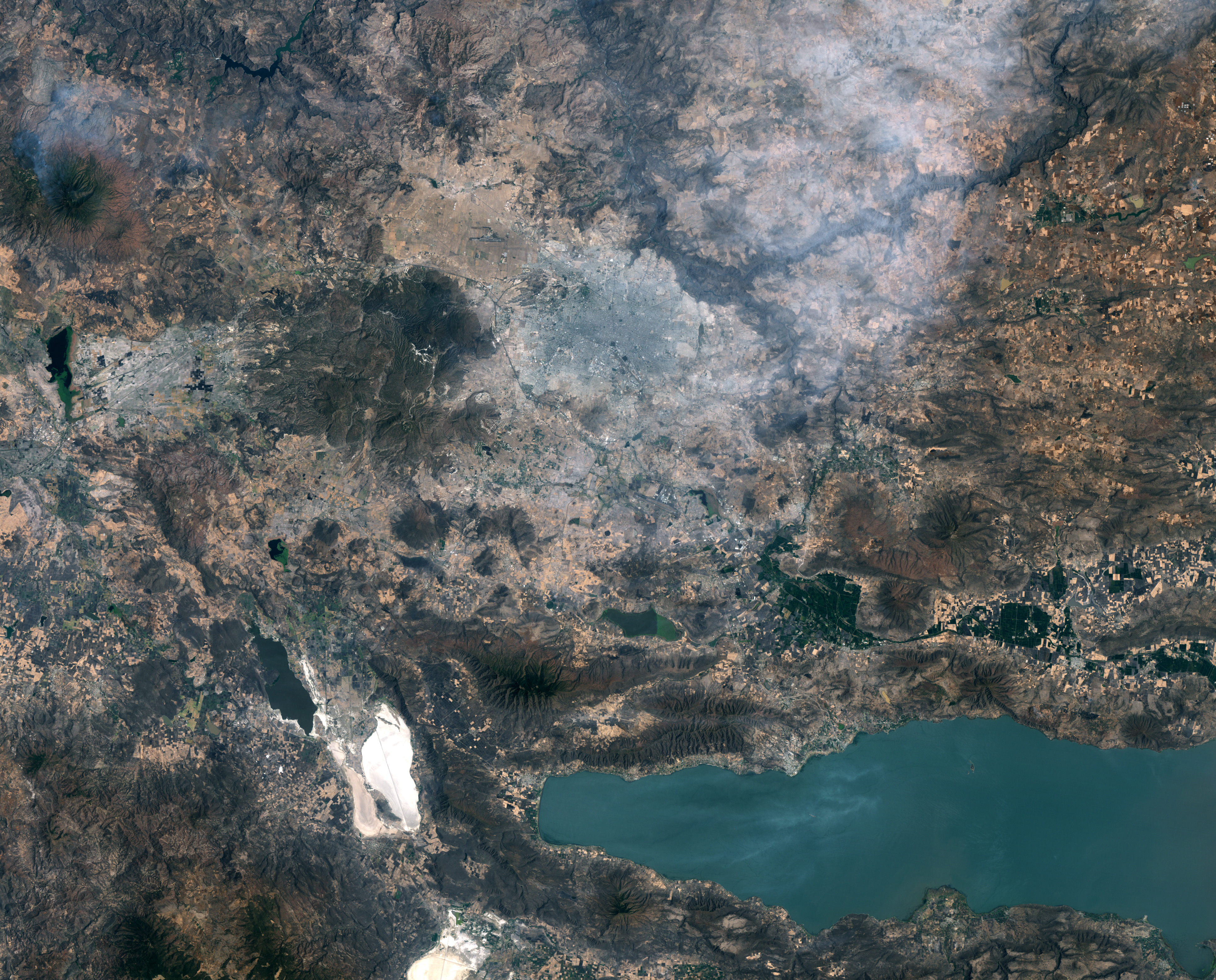
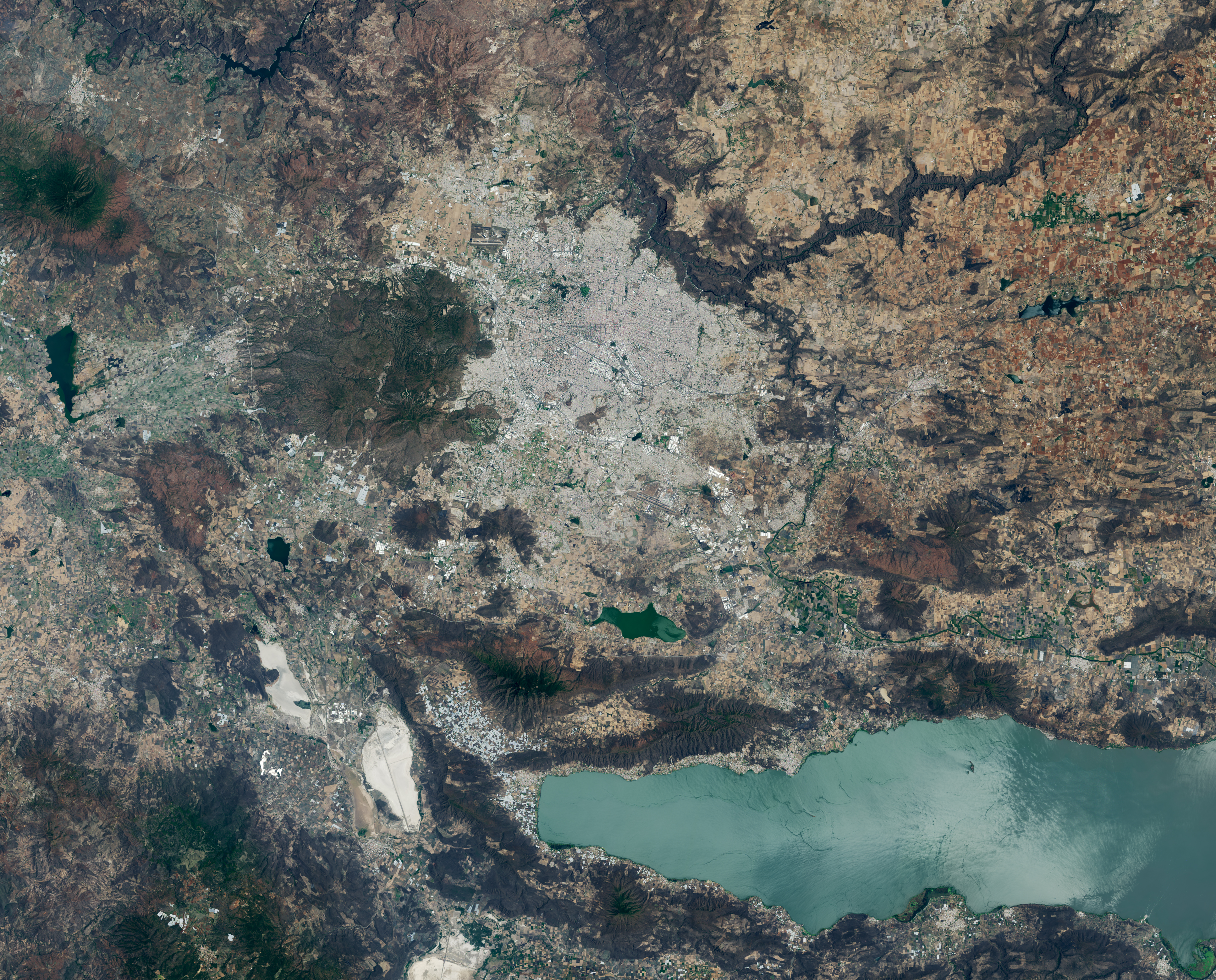
A pair of Landsat images shows 40 years of westward urban expansion from Guadalajara, Mexico. The Thematic Mapper on Landsat 5 captured the left image in 1986; the Operational Land Imager on Landsat 8 captured the right image in 2026.
A pair of Landsat images shows 40 years of westward urban expansion from Guadalajara, Mexico. The Thematic Mapper on Landsat 5 captured the left image in 1986; the Operational Land Imager on Landsat 8 captured the right image in 2026.
NASA Earth Observatory / Lauren Dauphin
A pair of Landsat images shows 40 years of westward urban expansion from Guadalajara, Mexico. The Thematic Mapper on Landsat 5 captured the left image in 1986; the Operational Land Imager on Landsat 8 captured the right image in 2026.
A pair of Landsat images shows 40 years of westward urban expansion from Guadalajara, Mexico. The Thematic Mapper on Landsat 5 captured the left image in 1986; the Operational Land Imager on Landsat 8 captured the right image in 2026.
NASA Earth Observatory / Lauren Dauphin
April 13, 1986
April 27, 2026
April 13, 1986 – April 27, 2026
A pair of Landsat images shows 40 years of westward urban expansion from Guadalajara, Mexico. The TM (Thematic Mapper) on Landsat 5 captured the left image in 1986; the OLI (Operational Land Imager) on Landsat 8 captured the right image in 2026.
Guadalajara, Mexico, was quite a different place when it last hosted World Cup games 40 years ago. The city welcomed matches in June 1986 and did so again in 2026, when South Korea faced Czechia at Guadalajara Stadium in the opening round of the 2026 FIFA World Cup.
In 1986, Guadalajara Stadium had not yet been built in Zapopan, the fast-growing municipality just northwest of Guadalajara. Many of that year’s World Cup matches were held instead at Jalisco Stadium in northeastern Guadalajara. It was in that stadium that France defeated Brazil in a penalty shootout in the 1986 quarterfinals, in what is widely regarded as one of the most memorable World Cup games of all time.
As seen in the Landsat images above, the land where Guadalajara Stadium (also called Estadio Akron) now sits was farmland in 1986. The new stadium, built in 2010 to host Mexico’s Club Deportivo Guadalajara, or Chivas, lies near the Sierra la Primavera volcanic complex, a rugged landscape full of lava flows, volcanic domes, steam vents, and hot springs. The architects who designed the stadium took inspiration from the nearby volcanic terrain, creating a structure that rises from a grassy earthen berm meant to resemble the flanks of a volcano, topped with a white roof reminiscent of a volcanic cloud.
About 95,000 years ago, the volcanic system underneath Sierra la Primavera produced a massive eruption that caused a caldera 11 kilometers (7 miles) in diameter to slump downward. Water filled the depression for tens of thousands of years, but tectonic uplift and the accumulation of sediment eventually led to the demise of the lake. Erosion wore away the softer surrounding rock over time, leaving harder, erosion-resistant volcanic rocks within the circular feature that now stand high above the surrounding terrain.
Starting about 60,000 years ago, several lava domes erupted along the southern edge of the caldera. The youngest of them, Cerro del Colli, formed about 30,000 years ago, leaving the dome-shaped feature just south of the stadium and contributing to a broader landscape dotted with other volcanic domes and cinder cones.
Today, much of the original caldera has been preserved as a forested area known as La Primavera Biosphere Reserve, even as development has partially encircled it during the past 40 years. The population of the Guadalajara metro area has grown from about 2.7 million in 1986 to more than 5.5 million now, with particularly rapid growth in Zapopan, a burgeoning tech hub sometimes billed as “Mexico’s Silicon Valley.” A prominent development visible in Landsat images is Guadalajara Technology Park, one of several new industrial parks in Zapopan. New greenhouses have also come to the area en masse, including south of the reserve, where they are mostly used to grow fruits and vegetables.
World Cup fever runs particularly high in Guadalajara, which is hosting World Cup matches for the third time. During Brazil’s legendary title run in 1970, when Pelé led the team, Jalisco Stadium was the venue for Brazil’s first-round, quarterfinal, and semifinal matches. To commemorate him, the city in May 2026 erected a 9.5-meter (31-foot) bronze statue of the iconic football (soccer) player.
Even the animals at Guadalajara Zoo are taking part in the festivities, with elephants, gorillas, giraffes, capybaras, pumas, and macaws “predicting” match winners by choosing between food, shirts, boxes, soccer balls, and other items. A puma named Muluk predicted South Korea would beat Czechia by sniffing and moving a ball, one newspaper reported.
Guadalajara will host four first-round matches: South Korea vs. Czechia on June 12, Mexico vs. South Korea on June 18, Colombia vs. Democratic Republic of the Congo on June 23, and Uruguay vs. Spain on June 26.
NASA Earth Observatory images by Lauren Dauphin, using Landsat data from the U.S. Geological Survey. Story by Adam Voiland.
A pair of Landsat images shows 40 years of westward urban expansion from Guadalajara, Mexico. The Thematic Mapper on Landsat 5 captured the left image in 1986; the Operational Land Imager on Landsat 8 captured the right image in 2026.
A pair of Landsat images shows 40 years of westward urban expansion from Guadalajara, Mexico. The Thematic Mapper on Landsat 5 captured the left image in 1986; the Operational Land Imager on Landsat 8 captured the right image in 2026.
NASA Earth Observatory / Lauren Dauphin
A pair of Landsat images shows 40 years of westward urban expansion from Guadalajara, Mexico. The Thematic Mapper on Landsat 5 captured the left image in 1986; the Operational Land Imager on Landsat 8 captured the right image in 2026.
A pair of Landsat images shows 40 years of westward urban expansion from Guadalajara, Mexico. The Thematic Mapper on Landsat 5 captured the left image in 1986; the Operational Land Imager on Landsat 8 captured the right image in 2026.
NASA Earth Observatory / Lauren Dauphin
April 13, 1986
April 27, 2026
April 13, 1986 – April 27, 2026
A pair of Landsat images shows 40 years of westward urban expansion from Guadalajara, Mexico. The TM (Thematic Mapper) on Landsat 5 captured the left image in 1986; the OLI (Operational Land Imager) on Landsat 8 captured the right image in 2026.
Guadalajara, Mexico, was quite a different place when it last hosted World Cup games 40 years ago. The city welcomed matches in June 1986 and did so again in 2026, when South Korea faced Czechia at Guadalajara Stadium in the opening round of the 2026 FIFA World Cup.
In 1986, Guadalajara Stadium had not yet been built in Zapopan, the fast-growing municipality just northwest of Guadalajara. Many of that year’s World Cup matches were held instead at Jalisco Stadium in northeastern Guadalajara. It was in that stadium that France defeated Brazil in a penalty shootout in the 1986 quarterfinals, in what is widely regarded as one of the most memorable World Cup games of all time.
As seen in the Landsat images above, the land where Guadalajara Stadium (also called Estadio Akron) now sits was farmland in 1986. The new stadium, built in 2010 to host Mexico’s Club Deportivo Guadalajara, or Chivas, lies near the Sierra la Primavera volcanic complex, a rugged landscape full of lava flows, volcanic domes, steam vents, and hot springs. The architects who designed the stadium took inspiration from the nearby volcanic terrain, creating a structure that rises from a grassy earthen berm meant to resemble the flanks of a volcano, topped with a white roof reminiscent of a volcanic cloud.
About 95,000 years ago, the volcanic system underneath Sierra la Primavera produced a massive eruption that caused a caldera 11 kilometers (7 miles) in diameter to slump downward. Water filled the depression for tens of thousands of years, but tectonic uplift and the accumulation of sediment eventually led to the demise of the lake. Erosion wore away the softer surrounding rock over time, leaving harder, erosion-resistant volcanic rocks within the circular feature that now stand high above the surrounding terrain.
Starting about 60,000 years ago, several lava domes erupted along the southern edge of the caldera. The youngest of them, Cerro del Colli, formed about 30,000 years ago, leaving the dome-shaped feature just south of the stadium and contributing to a broader landscape dotted with other volcanic domes and cinder cones.
Today, much of the original caldera has been preserved as a forested area known as La Primavera Biosphere Reserve, even as development has partially encircled it during the past 40 years. The population of the Guadalajara metro area has grown from about 2.7 million in 1986 to more than 5.5 million now, with particularly rapid growth in Zapopan, a burgeoning tech hub sometimes billed as “Mexico’s Silicon Valley.” A prominent development visible in Landsat images is Guadalajara Technology Park, one of several new industrial parks in Zapopan. New greenhouses have also come to the area en masse, including south of the reserve, where they are mostly used to grow fruits and vegetables.
World Cup fever runs particularly high in Guadalajara, which is hosting World Cup matches for the third time. During Brazil’s legendary title run in 1970, when Pelé led the team, Jalisco Stadium was the venue for Brazil’s first-round, quarterfinal, and semifinal matches. To commemorate him, the city in May 2026 erected a 9.5-meter (31-foot) bronze statue of the iconic football (soccer) player.
Even the animals at Guadalajara Zoo are taking part in the festivities, with elephants, gorillas, giraffes, capybaras, pumas, and macaws “predicting” match winners by choosing between food, shirts, boxes, soccer balls, and other items. A puma named Muluk predicted South Korea would beat Czechia by sniffing and moving a ball, one newspaper reported.
Guadalajara will host four first-round matches: South Korea vs. Czechia on June 12, Mexico vs. South Korea on June 18, Colombia vs. Democratic Republic of the Congo on June 23, and Uruguay vs. Spain on June 26.
NASA Earth Observatory images by Lauren Dauphin, using Landsat data from the U.S. Geological Survey. Story by Adam Voiland.
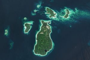
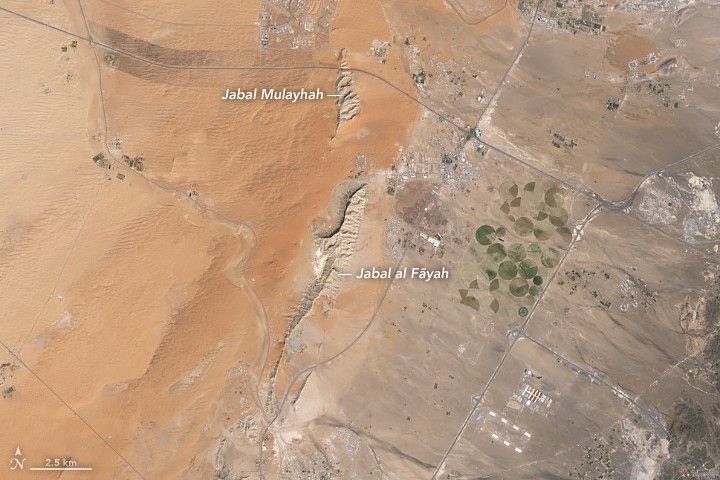
Jabal al Fāyah rises from the Rub’ al Khali desert in an image captured by the OLI (Operational Land Imager) on Landsat 8 on October 23, 2025.
NASA Earth Observatory / Lauren Dauphin
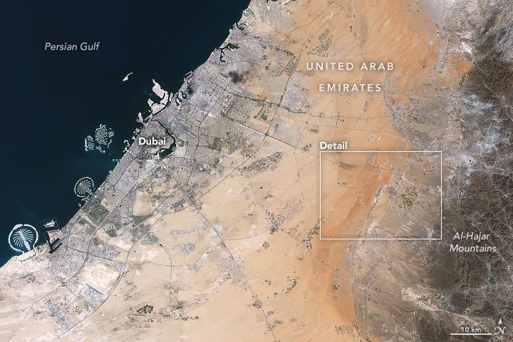
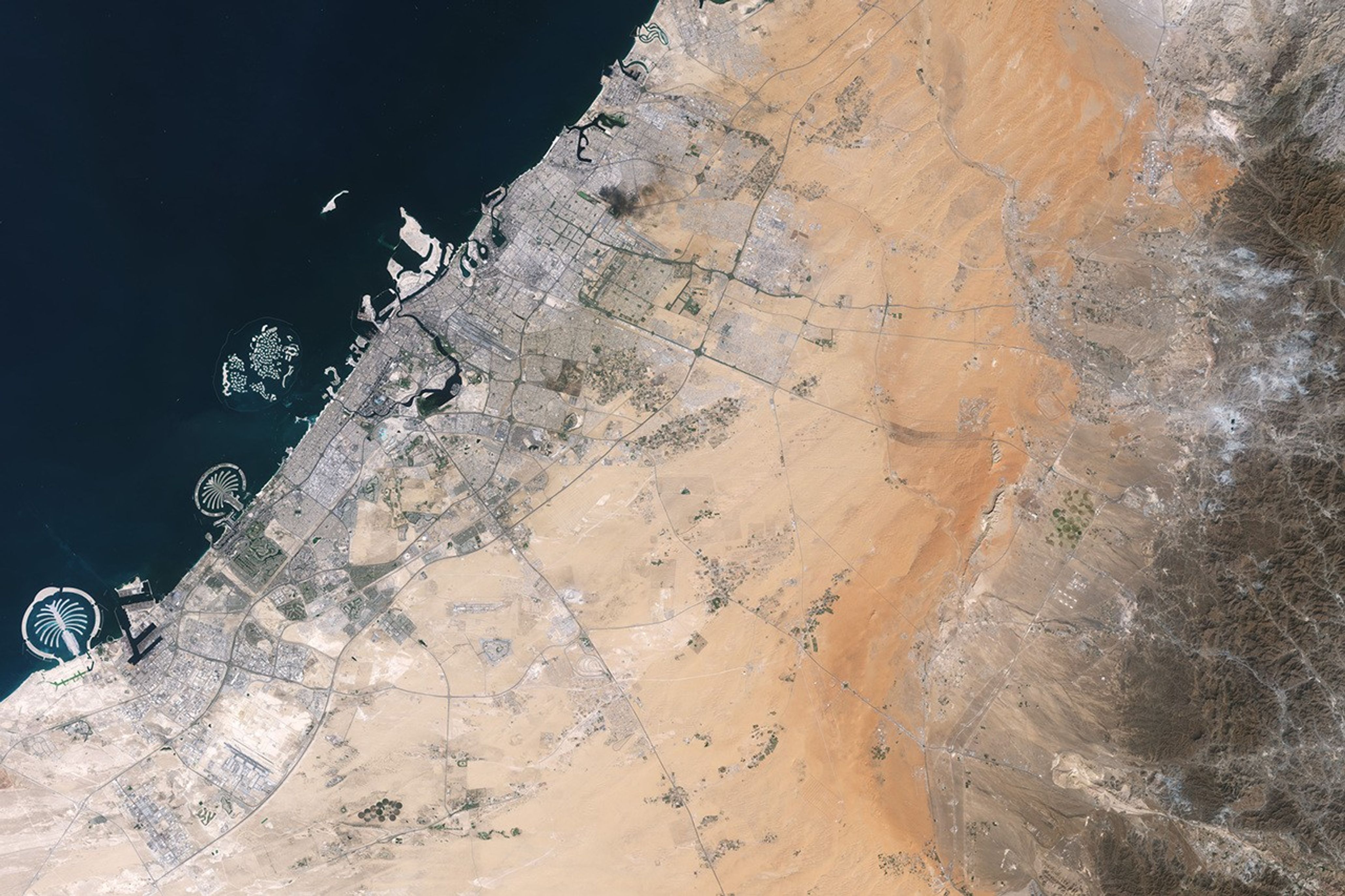
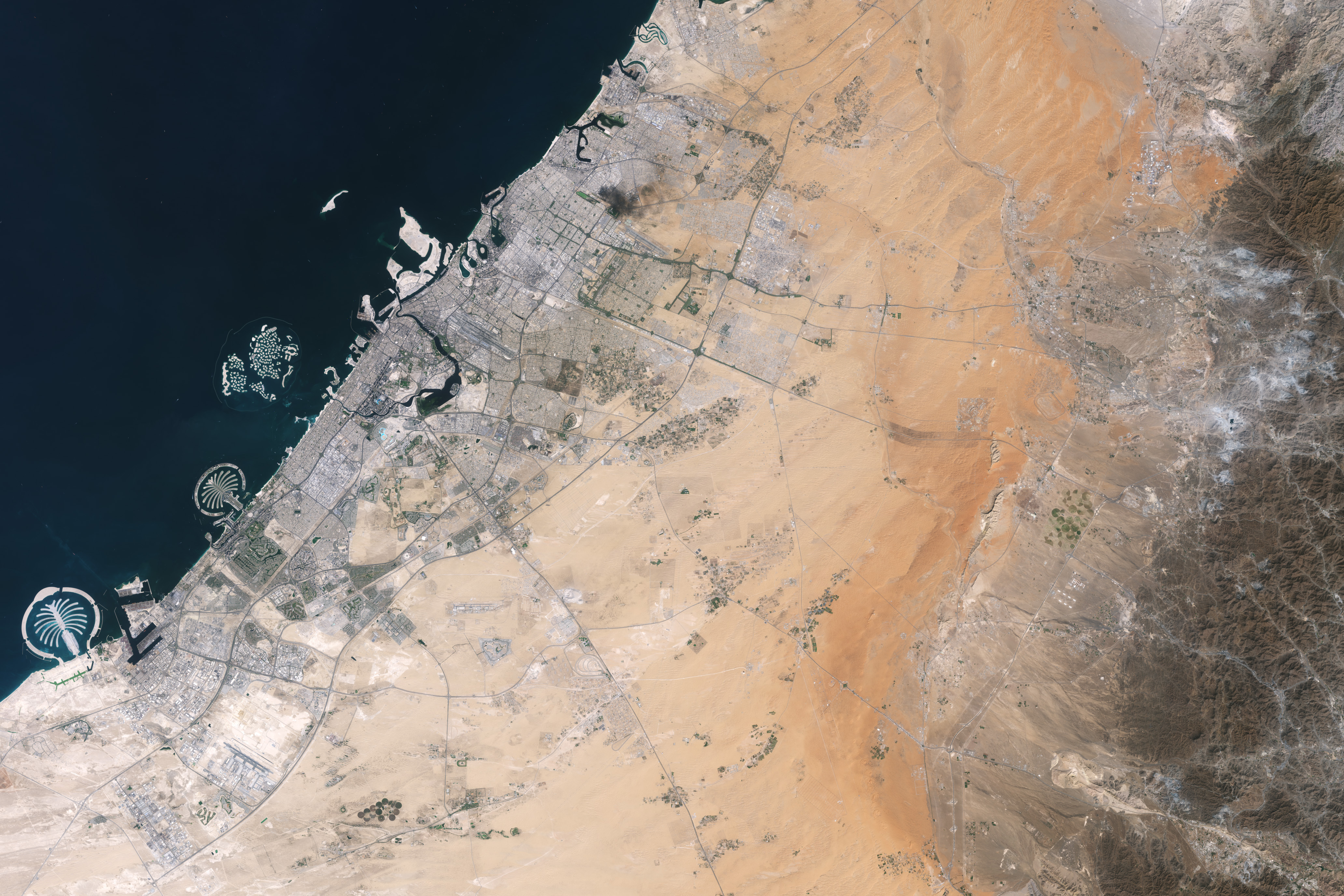
About an hour’s drive east of Dubai’s gleaming towers and artificial islands, a quieter, more natural landscape takes shape. At the far northern edge of the Rub’ al Khali, a saffron-colored sand sea laps against the Al-Hajar Mountains. A series of pale ridges rises finlike from the desert plain, with the largest—Jabal al Fāyah—standing 412 meters (1,352 feet) above sea level.
The Landsat 8 satellite captured this image of the ridges cutting across the Emirate of Sharjah in the northern part of the United Arab Emirates on October 23, 2025. To geologists, the limestone ridges are a reminder of the region’s watery past, signs that this land lay underwater tens of millions of years ago when the sedimentary rock layers were deposited.
Jabal al Fāyah functions as a barrier, trapping windblown sand in dune fields to its west. The weathering of iron-bearing minerals in the sand grains gives the dune fields their orange hue. To the east, the branching channels of overlapping alluvial fans extending from the Al-Hajar Mountains carry gravels and eroded sediments from basalts and other dark mafic rocks.
The dark rocks to the east—part of the Samail Ophiolite—are known to geologists for being among the world’s largest, best-preserved, and most accessible exposures of ancient oceanic lithosphere, the rigid outer layer of Earth that includes both the crust and upper mantle. Oceanic lithosphere like this is normally subducted and recycled back into the mantle when tectonic plates collide. But in this area, a large section from beneath the Tethys Sea was scraped off and thrust onto the Arabian plate in a process called obduction.
Dubai lies to the west of the limestone ridges, and the Al-Hajar Mountains lie to the east, in an image acquired by the OLI (Operational Land Imager) on Landsat 8 on October 23, 2025.
NASA Earth Observatory / Lauren Dauphin
The Jabal al Fāyah ridges themselves are made up of marine limestone that was deposited on top of the ophiolite over tens of millions of years spanning the late Cretaceous through the early to mid-Paleocene. Limestone typically forms along continental margins in warm, shallow oceans, often in lagoons and coral reefs, out of the calcium carbonate found in the shells and skeletons of marine life. In many parts of the ridges, coral fragments and marine invertebrate fossils are visible embedded in the rock. A feature called Fossil Rock sits a few kilometers north of Jabal al Fāyah and adjacent to the limestone ridge Jabal Mulayḩah. It contains an abundance of snail, clam, and sea urchin remains.
For archaeologists, the ridges are at the center of a much more recent tale of human adaptation and survival that has played out in just the past few hundred thousand years. The ridges and parts of the surrounding landscape—inscribed as a UNESCO World Heritage site in 2025—are dotted with dozens of archaeological sites that trace human occupation on the Arabian Peninsula back to between 210,000 and 120,000 years ago, to the Middle Paleolithic. That was a period when waves of anatomically modern humans (Homo sapiens) migrated out of Africa and shared the planet with other groups such as Neanderthals.
Many of the sites contain stone flakes, blades, scrapers, hand axes, and other stone tools. The archaeological treasure trove offers early evidence of modern humans surviving in a harsh desert environment and raises questions about the routes modern Homo sapiens may have taken on their journey out of Africa.
Geological evidence indicates that lakes periodically formed on the east side of the ridge, providing critical food and water resources that would have supported early inhabitants in this unforgiving climate. Rocky overhangs along the ridge would have provided shelter from the heat and wind. Some of the sites show evidence of intermittent occupation beginning as early as 210,000 years ago, making this one of the earliest signs of human habitation on the Arabian Peninsula.
NASA Earth Observatory images by Lauren Dauphin, using Landsat data from the U.S. Geological Survey. Story by Adam Voiland.

 Login