
❌

Normal view

What’s Up: August 2026 Skywatching Tips from NASA

31 July 2026 at 23:35

A solar eclipse, the Perseids, bright Venus after sunset, and a deep partial lunar eclipse highlight August’s skywatching.

Skywatching Highlights

  • Aug. 5: Last Quarter Moon
  • Aug. 12: Total solar eclipse across northern Russia, Greenland, Iceland, northern Spain, and part of Portugal; partial eclipse in parts of the U.S.; New Moon
  • Aug. 12-13: Perseid meteor shower peak under dark skies
  • Aug. 14-16: Venus reaches greatest eastern elongation and shines low in the west after sunset
  • Aug. 27-28: Partial lunar eclipse visible from much of North and South America and parts of Europe and Africa

Transcript

A solar eclipse, one of the year’s best meteor showers, Venus at its brightest in the evening sky, and a lunar eclipse to close out the month.

That’s “What’s Up” for August.

On Aug. 12, a total solar eclipse crosses northern Russia, Greenland, Iceland, and northern Spain, with a small corner of Portugal inside the path of totality.

In parts of the United States, from Alaska to North Carolina, the eclipse is partial. The Moon will take only a small bite out of the Sun, and the amount of coverage will vary with location.
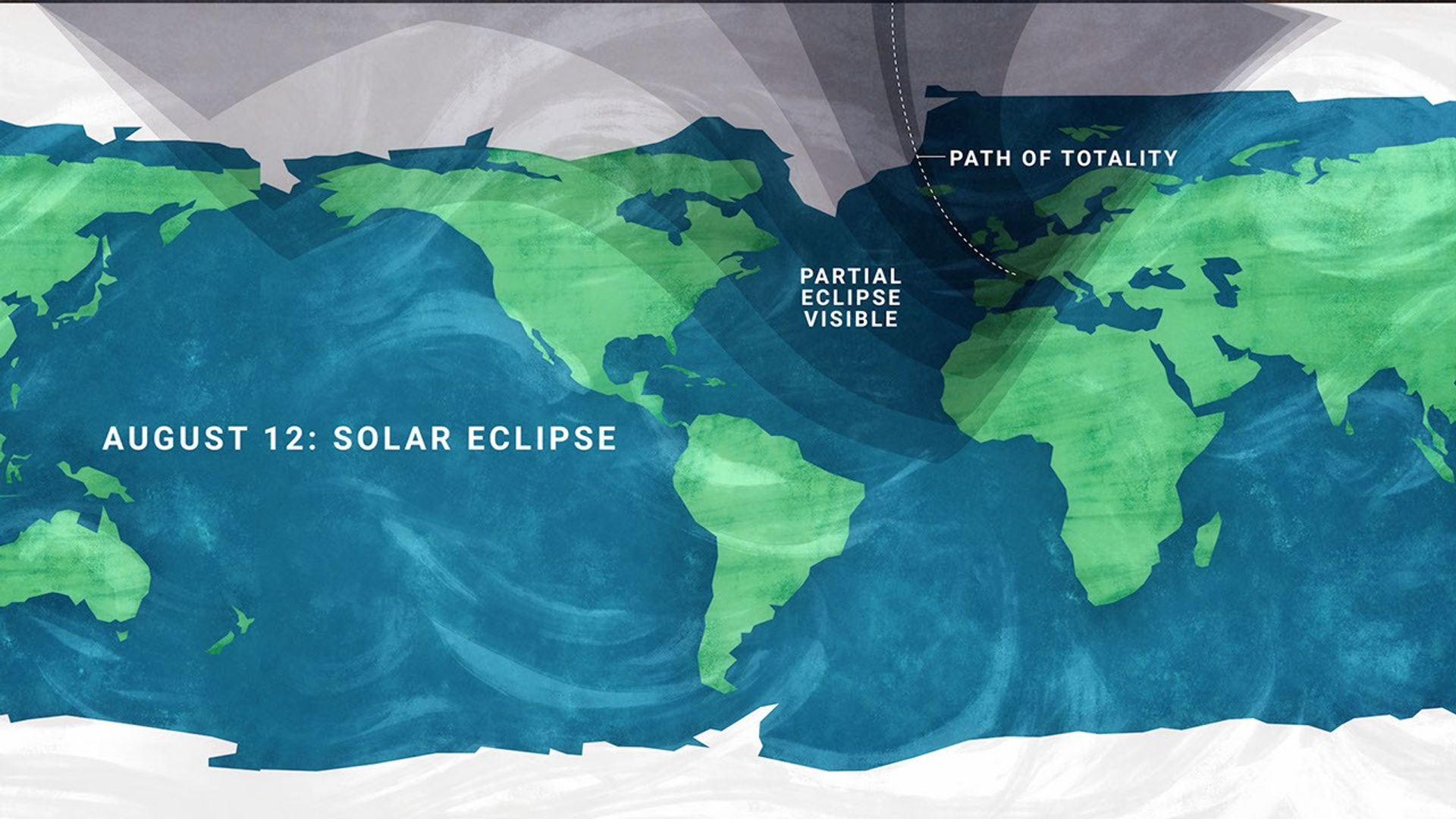
A stylized flat map of the Earth indicating the viewing areas for a solar eclipse, with text on the left reading 'AUGUST 12: SOLAR ECLIPSE'. A semi-transparent dark shadow covers the northern portion of the globe, fanning out from the top edge. Within this shadow, a thin dotted line arcs down from the Arctic, crossing near Greenland and Iceland, passing over the Iberian Peninsula (Spain and Portugal), and ending near the Mediterranean Sea; this line is labeled 'PATH OF TOTALITY'. The broader shaded region surrounding this line is labeled 'PARTIAL ECLIPSE VISIBLE', and it covers northern North America, the Arctic, all of Europe, northern Africa, and northern and western Asia. The unshaded regions covering the rest of the map, including most of the United States, South America, central and southern Africa, and Australia, indicate areas where the eclipse will not be visible.
A map showing viewing areas of the August 2026 total solar eclipse.
NASA/JPL-Caltech

Remember to watch safely. Use certified eclipse glasses or a safe solar viewer any time any part of the Sun is visible. Regular sunglasses are not safe. And never use binoculars, a telescope, or a camera without a solar filter made for the front of the optics.

Later that same night, the Perseid meteor shower will light up the sky, peaking the evening of Aug. 12 into the early morning hours of the 13th. And with a New Moon arriving on the 12th, the skies will be ideally dark.

The Perseids happen every year when Earth passes through a debris stream left behind by Comet Swift-Tuttle. As those tiny bits of comet dust hit our atmosphere at high speed, they burn up as bright streaks of light.

To view this meteor shower, look toward the northeast once it’s fully dark and watch for the constellation Perseus to clear the horizon. This is where the meteors originate, but let your eyes wander, because they can flash across any part of the sky.

For the best view, stay out late as the stars climb higher, find a dark open spot, and give your eyes 30 minutes to adjust.
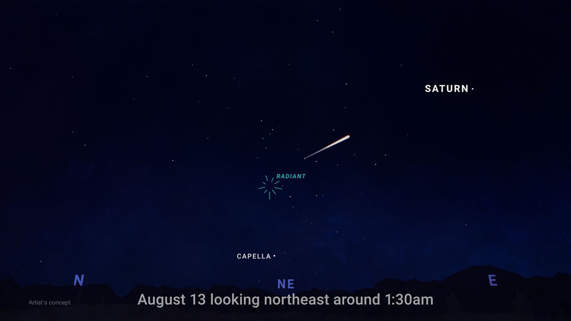
An illustration of the night sky showing where to look for meteors, with text at the bottom reading 'August 13 looking northeast around 1:30am.' The bottom of the image shows a dark, silhouetted horizon of hills, marked with blue compass directions N (North), NE (Northeast), and E (East). In the center of the sky above NE is a teal burst icon labeled 'RADIANT,' indicating the point from which meteors appear to originate. A bright, white meteor streaks across the dark, starry sky, pointing back toward the radiant. Two other bright celestial objects are labeled: the star 'CAPELLA' is situated low in the sky below the radiant, and the planet 'SATURN' is positioned high up in the upper right corner. Small text in the bottom left corner reads 'Artist's concept.'
This illustration shows where in the night sky to look for the Perseid meteor shower.
NASA/JPL-Caltech

Aug. 14-16, Venus reaches its greatest eastern elongation, which is its widest apparent separation from the Sun during this evening appearance.

Look low in the western sky shortly after sunset for the bright object that will outshine every star around it. Through a telescope after sunset, Venus will look close to half lit, like a tiny lunar phase.
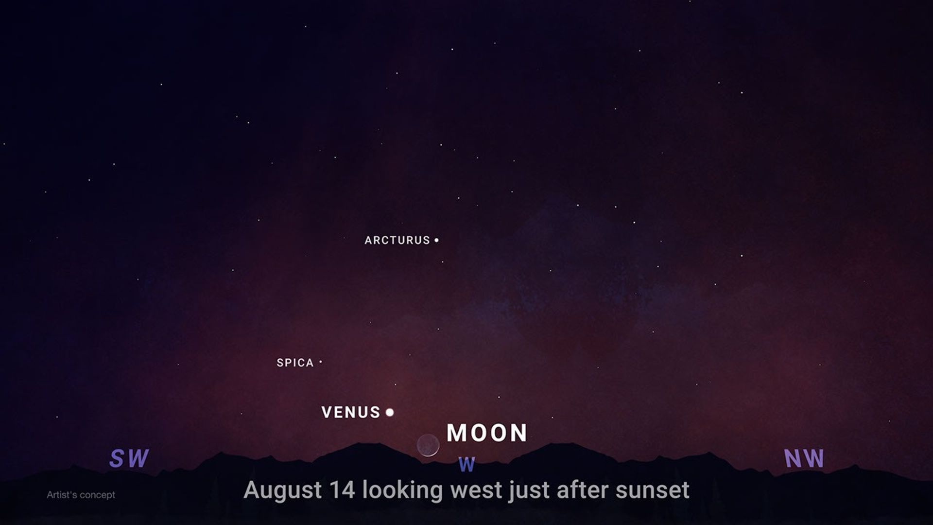
An illustration of the evening sky shortly after sunset, showing the positions of celestial objects. Text at the bottom center reads 'August 14 looking west just after sunset'. The bottom edge features a silhouetted, dark horizon of hills or mountains. Above the horizon, compass directions are indicated in purple: 'SW' (Southwest) on the left, 'W' (West) in the center, and 'NW' (Northwest) on the right. In the center, sitting very low on the horizon, is a faint crescent moon, labeled 'MOON'. Just to the left and slightly above the moon is a bright, white dot labeled 'VENUS'. Higher up and to the left of Venus is a smaller white dot labeled 'SPICA'. Above and to the right of Spica, towards the center of the image, is another labeled star, 'ARCTURUS'. The sky transitions from a deep reddish-purple near the horizon to dark blue at the top, sprinkled with numerous faint stars. In the bottom left corner, small text reads 'Artist's concept.'
This illustration shows where to observe Venus after sunset in August.
NASA/JPL-Caltech

On the night of Aug. 27, continuing into Aug. 28 for some time zones, the Full Moon slips through Earth’s shadow, resulting in a partial lunar eclipse. It will be visible from much of North and South America and parts of Europe and Africa.
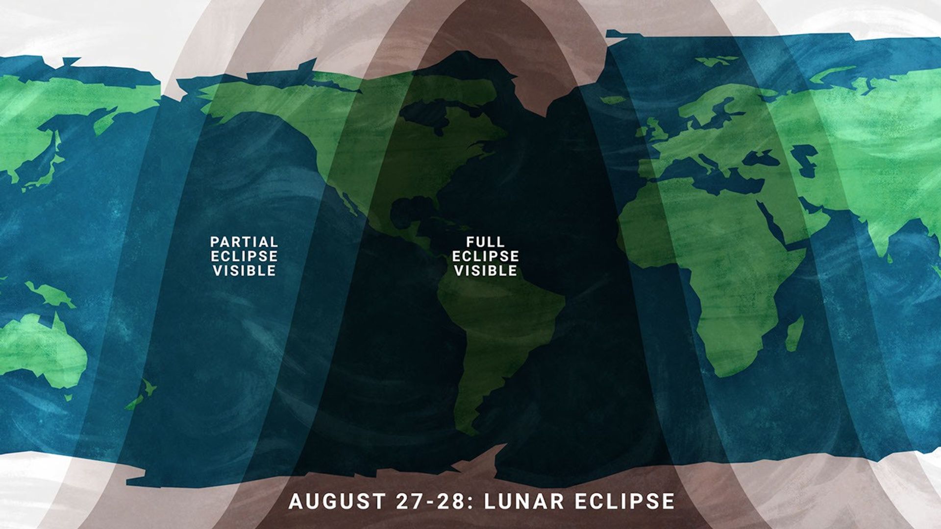
A stylized flat map of the Earth indicating the viewing areas for a lunar eclipse, with text at the bottom reading 'AUGUST 27-28: LUNAR ECLIPSE'. Large, semi-transparent dark bands arch across the map to represent visibility zones. The darkest central band, labeled 'FULL ECLIPSE VISIBLE', covers all of North America and South America, as well as the eastern Pacific Ocean and western Atlantic Ocean. Flanking this central region on the left and right are lighter shaded bands labeled 'PARTIAL ECLIPSE VISIBLE'. The western partial eclipse band covers the western Pacific Ocean and New Zealand, while the eastern partial eclipse band covers Europe and Africa. The unshaded outer regions of the map, including most of Asia and Australia, are areas where the eclipse will not be visible.
Viewing areas for the August 2026 lunar eclipse.
NASA/JPL-Caltech

At maximum eclipse, about 93% of the Moon’s diameter will be inside Earth’s dark central shadow, called the umbra. The Moon will not be completely covered, but it can look dramatically darkened, with a rusty, coppery tint along the covered edge.

Unlike a solar eclipse, a lunar eclipse is safe to watch with just your eyes. Binoculars or a small telescope can give you a closer view of Earth’s curved shadow moving across the Moon.

Here are the phases of the Moon for August.
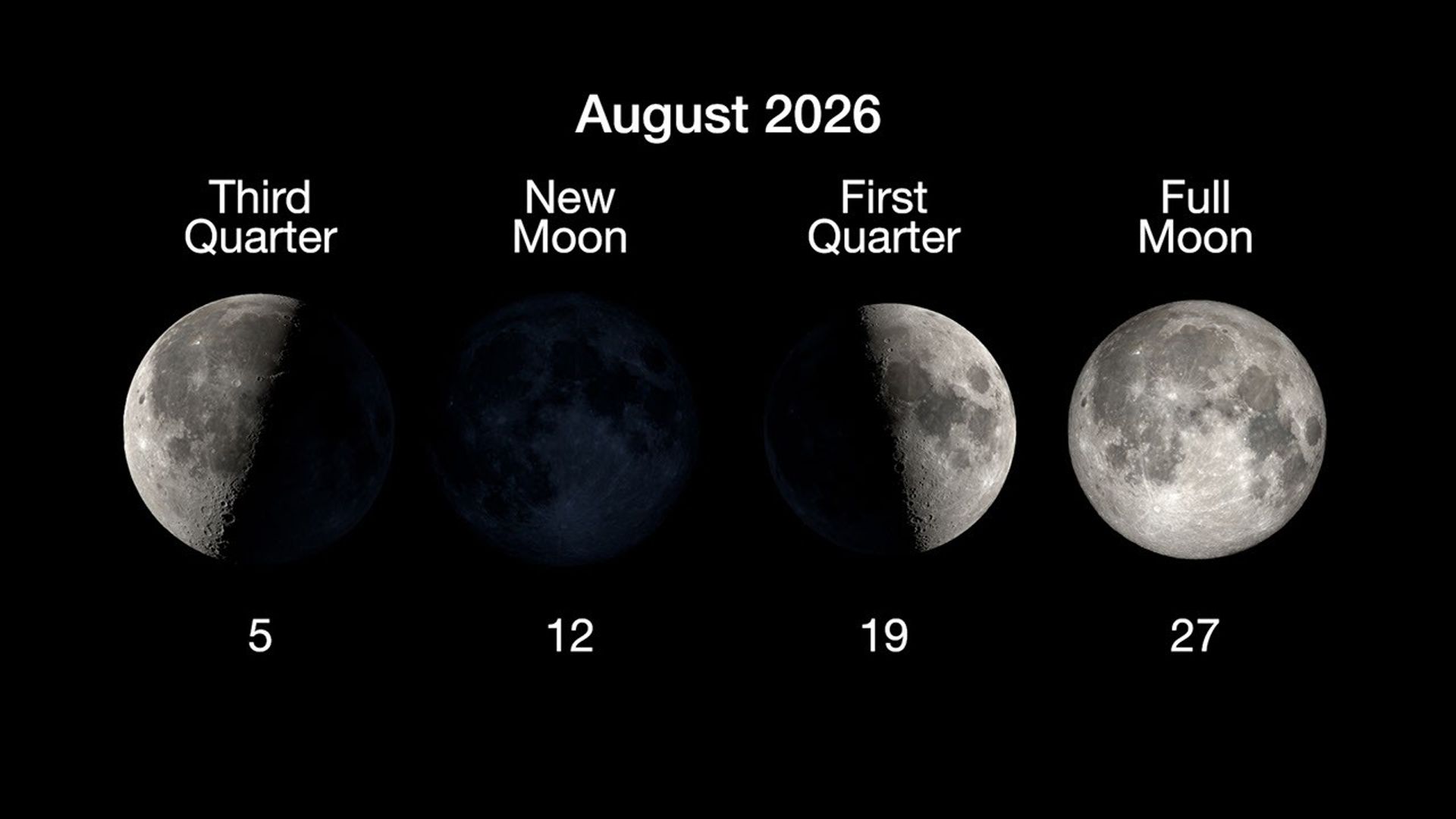
An infographic on a black background titled 'August 2026' showing four primary phases of the Moon arranged in a horizontal row. Each phase features an image of the Moon with text above indicating the phase name and a number below indicating the date in August. From left to right:  'Third Quarter' on the 5th, showing the left half of the Moon illuminated. 'New Moon' on the 12th, showing the Moon's face completely in shadow. 'First Quarter' on the 19th, showing the right half of the Moon illuminated. 'Full Moon' on the 27th, showing the entire face of the Moon illuminated.
NASA/JPL-Caltech

You can stay up to date on all of NASA’s missions exploring the solar system and beyond at science.nasa.gov. I’m Raquel Villanueva from NASA’s Jet Propulsion Laboratory, and that’s What’s Up for this month.

Keep Exploring

Discover More Topics From NASA

The post What’s Up: August 2026 Skywatching Tips from NASA appeared first on NASA Science.

💾

A solar eclipse, one of the year's best meteor showers, Venus at its brightest in the evening sky, and a partial lunar eclipse to close out the month.On Augu...

EAGLE

31 July 2026 at 23:02

EAGLE

Explorer for Artemis Geology, Lunar, and Earth — a NASA satellite program to study surface biology and geology on Earth, with technologies that could support future missions to the Moon and Mars.

Future Mission

NASA’s EAGLE program — Explorer for Artemis Geology, Lunar, and Earth — will be a series of satellite missions studying surface properties using technologies for Earth observation that will also benefit future missions to the Moon and Mars, where they could identify critical resources and safe landing sites.

The satellites making up the first two EAGLE missions will study biology and geology on Earth’s surface to support agriculture, disaster response, and other needs. Each mission will carry a different instrument with capabilities that complement each other. The first mission (EAGLE-VSWIR) is scheduled to take flight in 2028.

Mission Type

Orbiter

Target

Earth, Moon, Mars

Launch

No earlier than 2028

Objective

Study surface composition and changes

  • EAGLE-VSWIR

    EAGLE-VSWIR (Visible to Shortwave Infrared) will observe the Earth’s surface every 16 days with a high-resolution imaging spectrometer, which measures light reflected from the planet’s surface, separating wavelengths across the visual and into the infrared spectrum. The patterns created by light being reflected or absorbed across this spectral range act like fingerprints, letting scientists identify the composition of the surface. 

    A similar instrument, NASA’s EMIT (Earth Surface Mineral Dust Source Investigation), has been monitoring Earth from the International Space Station since July 2022, characterizing the surface mineral composition of Earth’s arid lands, monitoring ecosystem status, and tracking health and safety hazards — such as methane leaks and acid mine drainage — among other applications.

    EAGLE-VSWIR will have 25 times more capability than EMIT has today. This technological leap will allow scientists to map surface deposits of critical and rare-earth minerals, strengthen food security, and aid wildfire prevention and recovery. It can also highlight environmental hazards such as oil spills or landslide risks, and monitor water quality and availability.

    Region of Nevada as observed by NASA's EMIT with spectrum on right edge
    The front of this image cube shows a region in Nevada observed by NASA’s EMIT imaging spectrometer; the cube’s sides show the spectral fingerprint for every point in the image and can be used to discover mineral resources. EAGLE-VSWIR will have 25 times greater performance beyond NASA’s current state-of-the-art EMIT.
    NASA/JPL-Caltech
  • EAGLE-TIR

    The EAGLE-TIR mission will provide Thermal InfraRed (TIR) imagery when it launches two to three years after EAGLE-VSWIR, measuring energy emitted from the surface and producing data that scientists can use to map temperature, composition, and critical mineral deposits. On Earth that would let researchers monitor wildfires and volcanic activity, track drought and water use by crops, study urban heat islands, observe the rates that snow or ice accumulates or melts, and better understand Earth’s resilient ecosystems.

    EAGLE-TIR follows on from ECOSTRESS (ECOsystem Spaceborne Thermal Radiometer Experiment on Space Station), which has been observing Earth from the International Space Station since 2018. ECOSTRESS was designed to study how different ecosystems respond to drought and water stress, and the data has provided a vital understanding of how plants’ water use changes throughout the day. Since ECOSTRESS also measures emitted energy in the thermal infrared, its surface-temperature products have also been used for urban planning and wildfire monitoring. 

    Further innovation and lessons learned from ECOSTRESS has led to EAGLE-TIR, which will carry a multi-band thermal radiometer. EAGLE-TIR’s great strength compared to existing missions is that it provides detailed imagery of the entire globe every two days, day and night, at multiple wavelengths not available from other instruments.

    Aerial view of Namib desert in Infrared captured by ECOSTRESS
    This image shows the minerals contained in Namibian dunes using ECOSTRESS data. EAGLE-TIR will have more spectral channels to enable even better mineral discrimination.
    NASA/JPL-Caltech
  • EAGLE Program

    By advancing vital techniques for measuring our planet’s surface composition, resources, and hazards, the EAGLE program addresses critical needs in Earth observation, with technologies that can also transfer to planetary exploration, where they’ll serve as pathfinders for future missions to the Moon and Mars.

    015B0489.NEF
    As the Artemis II crew came close to passing behind the Moon and experiencing a planned loss of signal, they captured this image of a crescent Earth setting on the Moon’s limb on April 6, 2026.
    NASA
Featured Video

EAGLE

NASA unveiled the EAGLE program as one part of its “Ignition” event on March 24, 2026, when it announced a wide-ranging series of transformative agencywide initiatives. With EAGLE (the Explorer for Artemis Geology, Lunar, and Earth missions), NASA will deploy breakthrough hyperspectral images across Earth with later missions anticipated for the Moon and Mars in rapid succession. On Earth they’ll identify critical minerals for national security, enable precision agriculture, and support disaster response. On Earth and at Mars they will locate critical minerals and resources such as ice for propellants, rare-earth elements for technology, and construction materials for habitats.

EMIT

EMIT (Earth Surface Mineral Dust Source Investigation) measures the mineral composition of Earth’s dust source regions, to help scientists understand how they heat or cool our planet.

Learn More About EMIT

ECOSTRESS

ECOSTRESS (ECOsystem Spaceborne Thermal Radiometer Experiment on Space Station) is accurately measuring the temperature of plants on Earth.

Learn More About ECOSTRESS

The post EAGLE appeared first on NASA Science.

💾

Join us for continuing coverage as our leaders discuss the agency's implementation of the National Space Policy and our plans to advance science and discover...
❌