
❌

Normal view

NASA Testing Advanced Capabilities for Moon, Mars Rovers

18 June 2026 at 19:19
A white four-wheeled rover with a rectangular head on its mast projects a red glow onto a dark desert landscape. Pink and yellow hues indicate the sun has set behind a distant mountain range, while the top of the frame remains blue.
Developed at NASA’s Jet Propulsion Laboratory, ERNEST (Exploration Rover for Navigating Extreme Sloped Terrain) is used in a desert field test to help refine mobility hardware and autonomy software that could be used for a potential future long-range lunar rover mission.
A white four-wheeled rover on the left side of the frame casts a long shadow across barren, brown ground toward the lower right. A few low, scrubby plants dot the desert landscape and mountains rise in the far distance under a pale blue sky.
During the field test, which took place in March 2026 in the Colorado Desert of Southern California, the JPL team deployed ERNEST at all times of the day — including dusk, dawn, and nighttime, when lighting conditions create long shadows like those seen on the Moon’s polar regions.

On a bleak stretch of the Colorado Desert in Southern California, a compact four-wheeled rover recently trundled about 16 miles (26 kilometers) with minimal intervention from the team of engineers trailing it. Called ERNEST (Exploration Rover for Navigating Extreme Sloped Terrain), this prototype is being used by NASA to advance both robotic autonomy and the ability to traverse challenging landscapes.

Developed at NASA’s Jet Propulsion Laboratory in Southern California, ERNEST is 4 feet (1.2 meters) long. Not only can it lift each of its mesh wheels to get past obstacles that would stymie Curiosity and Perseverance, NASA’s six-wheeled Mars rovers, but the prototype also has enhanced independent decision-making capabilities. These mobility and autonomy advances could be infused into future missions that will venture to previously inaccessible areas of the Red Planet or the Moon.

ERNEST serves as a testbed for a potential future lunar rover mission requiring high speeds and extreme distances. In a recent field test, the prototype traveled 16 miles over the course of 37 hours, going an order of magnitude above the top speed at which NASA’s current Mars rovers can navigate. Credit: NASA/JPL-Caltech

In the field, ERNEST served as a testbed for a potential future lunar mission requiring higher speeds and much greater mileage than can be accomplished by current rovers. This technology could be used to inform future designs for exploration efforts on the Moon and beyond.

“This testing is helping us refine the mobility hardware and autonomy software to navigate extreme distances across a wide range of terrain and lighting conditions anticipated on the Moon,” said Issa Nesnas, a principal technologist at JPL who led the recent testing as head of autonomy for a NASA mission concept for a potential future long-range lunar rover.
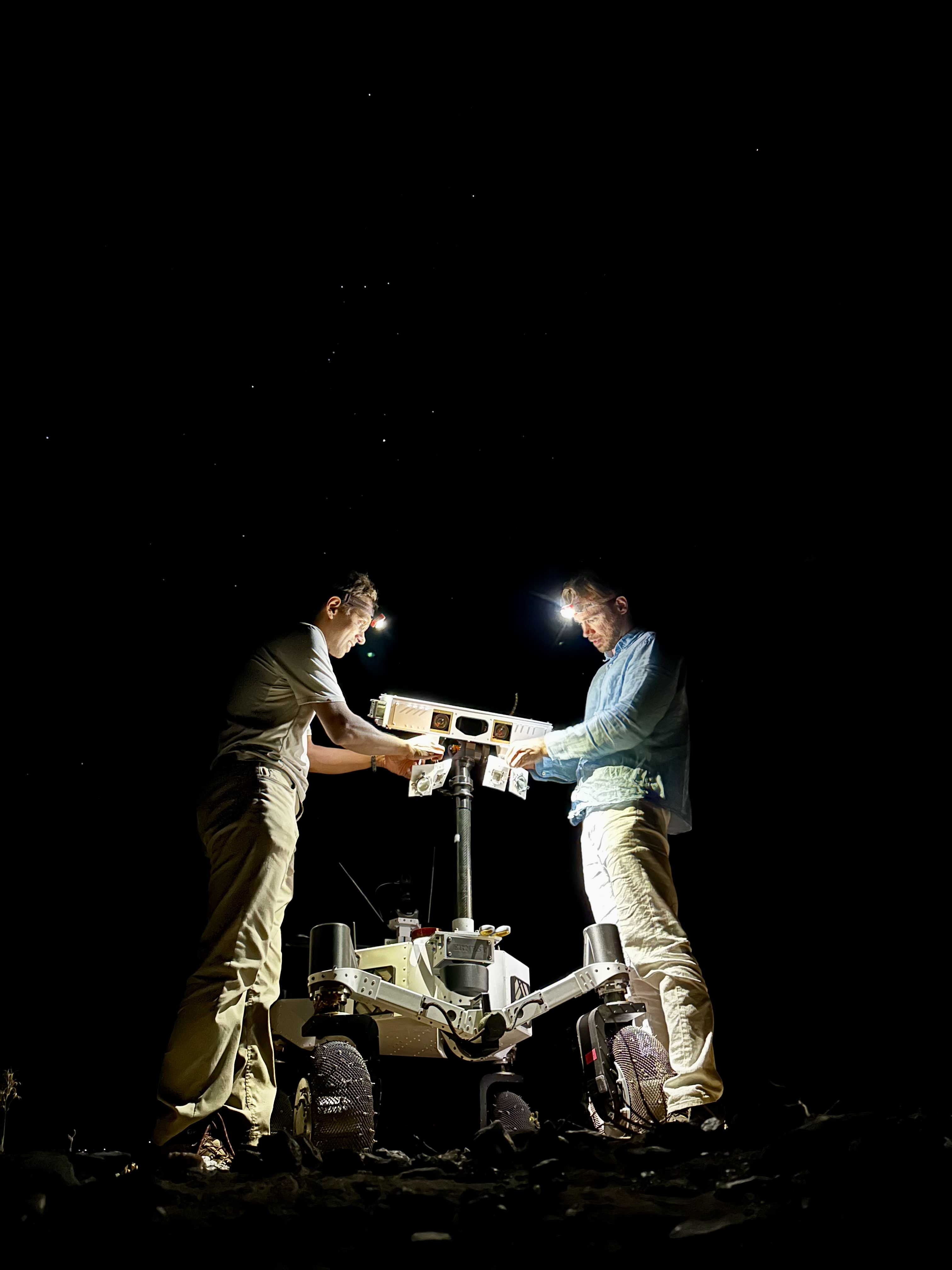
Against a pitch-black background sky in which a handful of white stars are visible, two men stand on either side of a 4.5-foot-tall white rover, which is lit up by the glow from their headlamps as they set up the illuminators on the robot’s mast.
Engineers from JPL set up illuminators after transporting ERNEST for a pre-sunrise test during a seven-day desert field campaign.
NASA/JPL-Caltech

Nesnas’ team is using ERNEST to demonstrate it is possible to build a rover that’s twice as big as the prototype and capable of a long-distance Moon mission. During the recent campaign, ERNEST traveled at speeds up to 0.6 mph (1 kph) over 37 hours of driving, across seven days of intermittent testing. That’s an order of magnitude above the top speed Perseverance and Curiosity can navigate.

“You could do a science road trip across the Moon — or Mars — with this vehicle,” said James Keane, a JPL planetary scientist working on lunar missions.

The initial goal of the team that developed ERNEST was mechanical: to design a relatively simple, low-cost rover that advances the trusted rocker-bogie suspension system featured on every Mars rover since NASA’s Sojourner. This passive system keeps relatively constant weight on all six wheels, thanks to pivot points and struts that enable each one to adapt to the changing surface.

The mobility and autonomy advances developed at JPL for the ERNEST prototype rover could be infused into future NASA missions to previously inaccessible areas of the Red Planet or the Moon. Credit: NASA/JPL-Caltech

On ERNEST, the active suspension lets the rover manage weight distribution among its wheels. Two powered joints in front articulate a gimbal that allows the rover to drive using different gaits like squirming, wheel-walking, and obstacle-climbing. With a clutch mechanism, it can switch between active and passive suspension, which is less terrain capable but more energy efficient. With four steerable wheels, it can drive in any direction, including sideways.

“We started by postulating that we could do better in designing a planetary surface robotic mobility system,” said Hari Nayar, a JPL principal technologist leading the ERNEST team. “While the rocker-bogie system has been very successful over the past 30 years, there’s been a lot of research in that time on mobility and understanding terrain interaction.”

Before arriving at today’s version of ERNEST, the team built two earlier prototypes, each about 2 feet (0.6 meters) long, to test 11 active suspension configurations. In a trailer filled with lunar regolith simulant, they ran experiments at different slope angles over several months before landing on a final design.

Then the team scaled up, including adding a rectangular head mounted on a 4.5-foot-tall (1.4-meter-tall) mast. The hardware was completed in September 2024, but the rover still needed a human operator to joystick it, sending commands to instruct the rover on how to move over obstacles.

In order to train the rover to think on its own, the ERNEST team turned to reinforcement learning, a type of artificial intelligence where the robot learns by interacting with its environment. The Dynamics and Real-Time Simulation Laboratory at JPL developed a high-fidelity virtual testing environment that replicates the rover’s behavior. The team fed the simulator data collected by engineers who documented the response of the actual rover hardware to a variety of terrain types. On a high-performance computing cluster, the team ran many simulations at once, sometimes completing thousands of hours of tests over a single weekend.

After months of virtual training, the ERNEST team was ready to see if the rover could use its new autonomous algorithms to figure out how to drive over terrain features that would halt a passive-suspension rover. They set up an obstacle course with sand ripples, rubble piles, steps, and steep slopes in JPL’s Mars Yard, an outdoor terrain proving ground. Then they watched as the rover maneuvered the terrain on its own. Since then, ERNEST has completed many such courses.

Nayar’s team is starting a new autonomy project which involves integrating the rover’s ability to determine when and how to use its active suspension with longer-range intelligent navigation. The goal is to enable ERNEST to plan an efficient path so that it can tackle surmountable obstacles and circumnavigate hazardous ones. These capabilities could contribute to potential future rover missions encountering formidable landscapes on Mars or more rugged areas of the Moon.

Work on ERNEST began in 2022 was initially supported by JPL internal research and development funds. It is currently funded by NASA’s Mars Exploration Program and the agency’s Exploration Science Strategy and Integration Office in its Science Mission Directorate at NASA Headquarters in Washington. Caltech in Pasadena, California, manages JPL for NASA.

Media Contacts

Karen Fox / Molly Wasser
NASA Headquarters, Washington
240-285-5155 / 240-419-1732
karen.c.fox@nasa.gov / molly.l.wasser@nasa.gov   

Melissa Pamer
Jet Propulsion Laboratory, Pasadena, Calif.
626-314-4928
melissa.pamer@jpl.nasa.gov

2026-040

The post NASA Testing Advanced Capabilities for Moon, Mars Rovers appeared first on NASA Science.
NASA Testing Advanced Capabilities for Moon, Mars Rovers

18 June 2026 at 19:19
A white four-wheeled rover with a rectangular head on its mast projects a red glow onto a dark desert landscape. Pink and yellow hues indicate the sun has set behind a distant mountain range, while the top of the frame remains blue.
Developed at NASA’s Jet Propulsion Laboratory, ERNEST (Exploration Rover for Navigating Extreme Sloped Terrain) is used in a desert field test to help refine mobility hardware and autonomy software that could be used for a potential future long-range lunar rover mission.
A white four-wheeled rover on the left side of the frame casts a long shadow across barren, brown ground toward the lower right. A few low, scrubby plants dot the desert landscape and mountains rise in the far distance under a pale blue sky.
During the field test, which took place in March 2026 in the Colorado Desert of Southern California, the JPL team deployed ERNEST at all times of the day — including dusk, dawn, and nighttime, when lighting conditions create long shadows like those seen on the Moon’s polar regions.

On a bleak stretch of the Colorado Desert in Southern California, a compact four-wheeled rover recently trundled about 16 miles (26 kilometers) with minimal intervention from the team of engineers trailing it. Called ERNEST (Exploration Rover for Navigating Extreme Sloped Terrain), this prototype is being used by NASA to advance both robotic autonomy and the ability to traverse challenging landscapes.

Developed at NASA’s Jet Propulsion Laboratory in Southern California, ERNEST is 4 feet (1.2 meters) long. Not only can it lift each of its mesh wheels to get past obstacles that would stymie Curiosity and Perseverance, NASA’s six-wheeled Mars rovers, but the prototype also has enhanced independent decision-making capabilities. These mobility and autonomy advances could be infused into future missions that will venture to previously inaccessible areas of the Red Planet or the Moon.

ERNEST serves as a testbed for a potential future lunar rover mission requiring high speeds and extreme distances. In a recent field test, the prototype traveled 16 miles over the course of 37 hours, going an order of magnitude above the top speed at which NASA’s current Mars rovers can navigate. Credit: NASA/JPL-Caltech

In the field, ERNEST served as a testbed for a potential future lunar mission requiring higher speeds and much greater mileage than can be accomplished by current rovers. This technology could be used to inform future designs for exploration efforts on the Moon and beyond.

“This testing is helping us refine the mobility hardware and autonomy software to navigate extreme distances across a wide range of terrain and lighting conditions anticipated on the Moon,” said Issa Nesnas, a principal technologist at JPL who led the recent testing as head of autonomy for a NASA mission concept for a potential future long-range lunar rover.

Against a pitch-black background sky in which a handful of white stars are visible, two men stand on either side of a 4.5-foot-tall white rover, which is lit up by the glow from their headlamps as they set up the illuminators on the robot’s mast.
Engineers from JPL set up illuminators after transporting ERNEST for a pre-sunrise test during a seven-day desert field campaign.
NASA/JPL-Caltech

Nesnas’ team is using ERNEST to demonstrate it is possible to build a rover that’s twice as big as the prototype and capable of a long-distance Moon mission. During the recent campaign, ERNEST traveled at speeds up to 0.6 mph (1 kph) over 37 hours of driving, across seven days of intermittent testing. That’s an order of magnitude above the top speed Perseverance and Curiosity can navigate.

“You could do a science road trip across the Moon — or Mars — with this vehicle,” said James Keane, a JPL planetary scientist working on lunar missions.

The initial goal of the team that developed ERNEST was mechanical: to design a relatively simple, low-cost rover that advances the trusted rocker-bogie suspension system featured on every Mars rover since NASA’s Sojourner. This passive system keeps relatively constant weight on all six wheels, thanks to pivot points and struts that enable each one to adapt to the changing surface.

The mobility and autonomy advances developed at JPL for the ERNEST prototype rover could be infused into future NASA missions to previously inaccessible areas of the Red Planet or the Moon. Credit: NASA/JPL-Caltech

On ERNEST, the active suspension lets the rover manage weight distribution among its wheels. Two powered joints in front articulate a gimbal that allows the rover to drive using different gaits like squirming, wheel-walking, and obstacle-climbing. With a clutch mechanism, it can switch between active and passive suspension, which is less terrain capable but more energy efficient. With four steerable wheels, it can drive in any direction, including sideways.

“We started by postulating that we could do better in designing a planetary surface robotic mobility system,” said Hari Nayar, a JPL principal technologist leading the ERNEST team. “While the rocker-bogie system has been very successful over the past 30 years, there’s been a lot of research in that time on mobility and understanding terrain interaction.”

Before arriving at today’s version of ERNEST, the team built two earlier prototypes, each about 2 feet (0.6 meters) long, to test 11 active suspension configurations. In a trailer filled with lunar regolith simulant, they ran experiments at different slope angles over several months before landing on a final design.

Then the team scaled up, including adding a rectangular head mounted on a 4.5-foot-tall (1.4-meter-tall) mast. The hardware was completed in September 2024, but the rover still needed a human operator to joystick it, sending commands to instruct the rover on how to move over obstacles.

In order to train the rover to think on its own, the ERNEST team turned to reinforcement learning, a type of artificial intelligence where the robot learns by interacting with its environment. The Dynamics and Real-Time Simulation Laboratory at JPL developed a high-fidelity virtual testing environment that replicates the rover’s behavior. The team fed the simulator data collected by engineers who documented the response of the actual rover hardware to a variety of terrain types. On a high-performance computing cluster, the team ran many simulations at once, sometimes completing thousands of hours of tests over a single weekend.

After months of virtual training, the ERNEST team was ready to see if the rover could use its new autonomous algorithms to figure out how to drive over terrain features that would halt a passive-suspension rover. They set up an obstacle course with sand ripples, rubble piles, steps, and steep slopes in JPL’s Mars Yard, an outdoor terrain proving ground. Then they watched as the rover maneuvered the terrain on its own. Since then, ERNEST has completed many such courses.

Nayar’s team is starting a new autonomy project which involves integrating the rover’s ability to determine when and how to use its active suspension with longer-range intelligent navigation. The goal is to enable ERNEST to plan an efficient path so that it can tackle surmountable obstacles and circumnavigate hazardous ones. These capabilities could contribute to potential future rover missions encountering formidable landscapes on Mars or more rugged areas of the Moon.

Work on ERNEST began in 2022 was initially supported by JPL internal research and development funds. It is currently funded by NASA’s Mars Exploration Program and the agency’s Exploration Science Strategy and Integration Office in its Science Mission Directorate at NASA Headquarters in Washington. Caltech in Pasadena, California, manages JPL for NASA.

Media Contacts

Karen Fox / Molly Wasser
NASA Headquarters, Washington
240-285-5155 / 240-419-1732
karen.c.fox@nasa.gov / molly.l.wasser@nasa.gov   

Melissa Pamer
Jet Propulsion Laboratory, Pasadena, Calif.
626-314-4928
melissa.pamer@jpl.nasa.gov

2026-040

💾

Engineers from NASA’s Jet Propulsion Laboratory are field-testing advanced capabilities for potential future Moon and Mars rovers. In the Colorado Desert nea...

El Niño Is Underway

18 June 2026 at 05:00
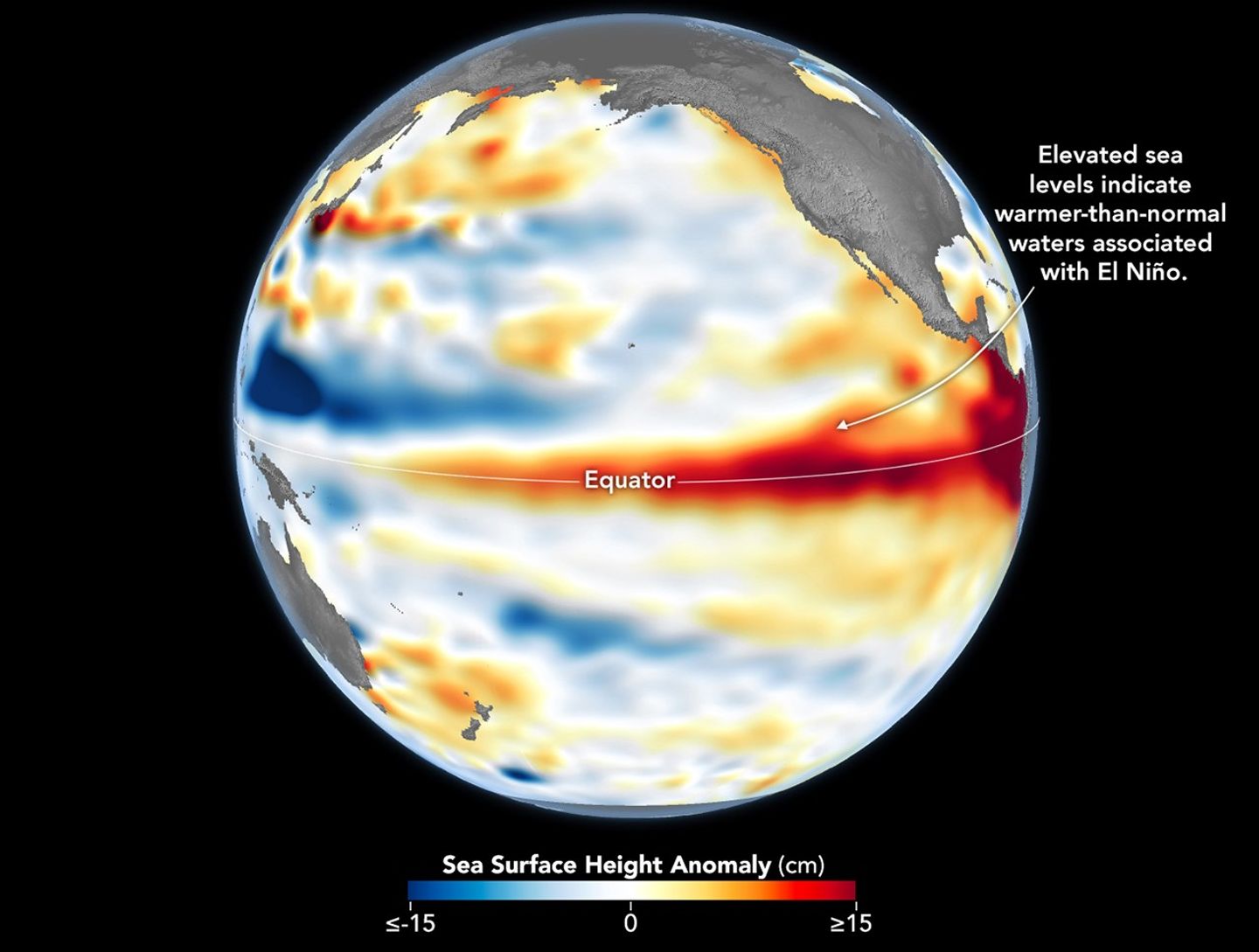
A global map centered on the Pacific Ocean shows a band of red, higher-than-normal water levels across the central and eastern equatorial Pacific and a broad patch off the coast of South America.
Higher-than-normal sea surfaces (red) are visible in the central and eastern Pacific on June 8, 2026, a few days before El Niño was declared. Data for the map were acquired by the Sentinel-6 Michael Freilich satellite and processed by scientists at NASA’s Jet Propulsion Laboratory (JPL).
NASA Earth Observatory/Lauren Dauphin

El Niño, characterized by warmer-than-normal water temperatures in parts of the equatorial Pacific, made its return in June 2026. Observations of sea surface height from the Sentinel-6 Michael Freilich satellite that month indicated that the 2026 event was continuing to strengthen.  

The natural, recurring phenomenon can have widespread effects, typically bringing wetter conditions to the U.S. Southwest and drought to countries in the western Pacific, such as Indonesia and Australia. NOAA declared an El Niño on June 11, after sea surface temperatures in the central and eastern equatorial Pacific measured at least 0.5 degrees Celsius above average for several consecutive months.

Meanwhile, NASA scientists have been observing a complementary sign of El Niño: areas of elevated sea surface height. When ocean water warms, it expands in volume and causes the sea surface to rise—making the water’s height a reliable indicator of ocean temperatures. Warmer-than-normal temperatures, hence higher sea surface heights, in parts of the equatorial Pacific Ocean are associated with El Niño.

The map above depicts sea surface height anomalies across the central and eastern Pacific Ocean as observed on June 8, 2026. Shades of red indicate sea levels that were higher than average. Normal sea level conditions appear white, and lower areas are blue.  

Data for the map were acquired by the Sentinel-6 Michael Freilich satellite—launched in 2020 by NASA and led by ESA (European Space Agency)—and processed by scientists at NASA’s Jet Propulsion Laboratory (JPL). Note that signals related to seasonal cycles and long-term trends have been removed to highlight sea level anomalies associated with El Niño and other short-term natural phenomena.

Earlier in spring 2026, the satellite started to detect precursor signs of El Niño as swells of warm water hundreds of miles wide, known as Kelvin waves, moved from the western Pacific to the eastern Pacific. That happens when trade winds in the western equatorial Pacific weaken and then temporarily reverse to blow from the west. Warm water piles up in the east, deepening the warm surface layer, lowering the thermocline, and suppressing the upwelling that usually keeps waters along the Pacific coasts of the Americas cooler.

This buildup of heat beneath the water’s surface is what sea surface height observations capture. It goes beyond surface temperature measurements to indicate how much heat is stored in the subsurface. That’s important because a shallow warm layer might not have much impact on climate and weather, while a large reservoir of heat below the surface can matter more.

According to JPL sea level researcher Severine Fournier, deputy project scientist for Sentinel-6 Michael Freilich, conditions in the western Pacific on June 8 looked similar to those from the same time in 1997, a year when an exceptionally strong El Niño emerged. Warm conditions in the eastern Pacific in 2026 have lagged behind, however, with fewer Kelvin waves built up by the same date.

Still, more warm Kelvin waves appeared to be approaching the eastern Pacific, meaning El Niño was still strengthening. Whether it catches up to 1997 depends on ocean activity in the coming weeks. “For now, it looks like it’s going to be a big one—more so than I would have said last week—but we still need more observations to know what’s going to happen.”

NASA Earth Observatory image by Lauren Dauphin, using modified Copernicus Sentinel data (2023) processed by the European Space Agency and further processed by Josh Willis, Severin Fournier, and Kevin Marlis/NASA/JPL-Caltech. Story by Kathryn Hansen.

Downloads

A global map centered on the Pacific Ocean shows a band of red, higher-than-normal water levels across the central and eastern equatorial Pacific and a broad patch off the coast of South America.

June 8, 2026

JPEG (1.19 MB)

References & Resources

You may also be interested in:

Stay up-to-date with the latest content from NASA as we explore the universe and discover more about our home planet.

Barents Sea Tied to Low Arctic Sea Ice
4 min read

Patches of open water in the region contributed to low sea ice extent across the Arctic in March 2026, which…

Article
New Eruption in the Bismarck Sea
5 min read

Satellite imagery shows a surge of new volcanic activity in the ocean near Papua New Guinea.

Article
Color Off the Mid-Atlantic Coast
4 min read

Something is brewing in shallow waters offshore of Delaware, New Jersey, Maryland, and Virginia.

Article

The post El Niño Is Underway appeared first on NASA Science.

El Niño Is Underway

18 June 2026 at 05:00
A global map centered on the Pacific Ocean shows a band of red, higher-than-normal water levels across the central and eastern equatorial Pacific and a broad patch off the coast of South America.
Higher-than-normal sea surfaces (red) are visible in the central and eastern Pacific on June 8, 2026, a few days before El Niño was declared. Data for the map were acquired by the Sentinel-6 Michael Freilich satellite and processed by scientists at NASA’s Jet Propulsion Laboratory (JPL).
NASA Earth Observatory/Lauren Dauphin

El Niño, characterized by warmer-than-normal water temperatures in parts of the equatorial Pacific, made its return in June 2026. Observations of sea surface height from the Sentinel-6 Michael Freilich satellite that month indicated that the 2026 event was continuing to strengthen.  

The natural, recurring phenomenon can have widespread effects, typically bringing wetter conditions to the U.S. Southwest and drought to countries in the western Pacific, such as Indonesia and Australia. NOAA declared an El Niño on June 11, after sea surface temperatures in the central and eastern equatorial Pacific measured at least 0.5 degrees Celsius above average for several consecutive months.

Meanwhile, NASA scientists have been observing a complementary sign of El Niño: areas of elevated sea surface height. When ocean water warms, it expands in volume and causes the sea surface to rise—making the water’s height a reliable indicator of ocean temperatures. Warmer-than-normal temperatures, hence higher sea surface heights, in parts of the equatorial Pacific Ocean are associated with El Niño.

The map above depicts sea surface height anomalies across the central and eastern Pacific Ocean as observed on June 8, 2026. Shades of red indicate sea levels that were higher than average. Normal sea level conditions appear white, and lower areas are blue.  

Data for the map were acquired by the Sentinel-6 Michael Freilich satellite—launched in 2020 by NASA and led by ESA (European Space Agency)—and processed by scientists at NASA’s Jet Propulsion Laboratory (JPL). Note that signals related to seasonal cycles and long-term trends have been removed to highlight sea level anomalies associated with El Niño and other short-term natural phenomena.

Earlier in spring 2026, the satellite started to detect precursor signs of El Niño as swells of warm water hundreds of miles wide, known as Kelvin waves, moved from the western Pacific to the eastern Pacific. That happens when trade winds in the western equatorial Pacific weaken and then temporarily reverse to blow from the west. Warm water piles up in the east, deepening the warm surface layer, lowering the thermocline, and suppressing the upwelling that usually keeps waters along the Pacific coasts of the Americas cooler.

This buildup of heat beneath the water’s surface is what sea surface height observations capture. It goes beyond surface temperature measurements to indicate how much heat is stored in the subsurface. That’s important because a shallow warm layer might not have much impact on climate and weather, while a large reservoir of heat below the surface can matter more.

According to JPL sea level researcher Severine Fournier, deputy project scientist for Sentinel-6 Michael Freilich, conditions in the western Pacific on June 8 looked similar to those from the same time in 1997, a year when an exceptionally strong El Niño emerged. Warm conditions in the eastern Pacific in 2026 have lagged behind, however, with fewer Kelvin waves built up by the same date.

Still, more warm Kelvin waves appeared to be approaching the eastern Pacific, meaning El Niño was still strengthening. Whether it catches up to 1997 depends on ocean activity in the coming weeks. “For now, it looks like it’s going to be a big one—more so than I would have said last week—but we still need more observations to know what’s going to happen.”

NASA Earth Observatory image by Lauren Dauphin, using modified Copernicus Sentinel data (2023) processed by the European Space Agency and further processed by Josh Willis, Severin Fournier, and Kevin Marlis/NASA/JPL-Caltech. Story by Kathryn Hansen.

Downloads

A global map centered on the Pacific Ocean shows a band of red, higher-than-normal water levels across the central and eastern equatorial Pacific and a broad patch off the coast of South America.

June 8, 2026

JPEG (1.19 MB)

References & Resources

You may also be interested in:

Stay up-to-date with the latest content from NASA as we explore the universe and discover more about our home planet.

Barents Sea Tied to Low Arctic Sea Ice
4 min read

Patches of open water in the region contributed to low sea ice extent across the Arctic in March 2026, which…

Article
New Eruption in the Bismarck Sea
5 min read

Satellite imagery shows a surge of new volcanic activity in the ocean near Papua New Guinea.

Article
Color Off the Mid-Atlantic Coast
4 min read

Something is brewing in shallow waters offshore of Delaware, New Jersey, Maryland, and Virginia.

Article
❌