Climate change is often discussed in terms of rising temperatures, extreme weather and environmental loss. But there's another consequence that can be harder to see: The impact on our mental health.
Editor's Note: This text was updated at 12:30 p.m. EDT to correct the spelling of Kim Meidenbauer's name.
Burning up: How can we adapt to a warming world?
As the planet warms, our environment will be transformed, but so will our bodies. This video is part of a series where we investigate the health impacts of climate change, focusing on heat, air quality, food and infection risk. We also evaluate the promising solutions that could help us adapt to our warmer future.
'Wildfire smoke is the fastest-growing environmental threat in the US': How a warming world will poison the air we breathe
Wildfires are projected to increase dramatically due to climate change. That could trigger a massive increase in heart attacks, premature births and early deaths, research reveals.
What's in the photo? The point where two different-colored lakes meet
Who took the photo? An unnamed astronaut on board the International Space Station
When was it taken? Sept. 15, 2020
This eye-catching astronaut photo shows the point where an ancient Patagonian lake has been split by a peculiar land bridge, creating two contrastingly colored bodies of water.
Lake Pueyrredón (on the left in the photo) is the Argentine half of a roughly 40-mile-long (65 kilometers) glacial lake, which stretches across the country's border with Chile in Patagonia — a region in South America that is well known for its diverse range of geographic features, including mountains, fjords, deserts and rainforests. The Chilean half of the lake is known as Lake Cochrane (not shown in this image). Both halves hold crystal-clear water that is up to 1,600 feet (500 meters) deep, giving Pueyrredón a deep blue hue when viewed from above.
Thousands of years ago, a thick sediment barrier formed across the southern section of Lake Pueyrredón, creating a new body of water known as Lake Posadas. This smaller body, which is roughly 5 miles (8 km) long, has a lighter, teal color due to its shallow water and a large influx of sediment from a nearby river, according to NASA's Earth Observatory.
Other rivers from nearby hills have previously dumped large quantities of sediment along the western shore of Lake Pueyrredón (bottom of the photo), creating a trio of fan-shaped landforms, known as deltas, that increase in size from north to south (left to right in the photo).
Wind-driven currents and waves have pushed some of this sediment from the outer edges of the two smaller deltas, creating long, thin strips of land, known as sandspits, pointing down-current.
This image, snapped from the banks of Lake Posadas, shows a close-up view of the rocky barrier that formed across Lake Pueyrredón thousands of years ago. (Image credit: Prisma Bildagentur/Universal Images Group via Getty Images)
The strip of land separating Pueyrredón and Posadas looks similar to the sandspits. However, it is most likely a moraine — a barrier of sediment and larger rocks that formed along the edge of a hefty iceberg or long-lost glacier, according to the Earth Observatory.
Eagle-eyed viewers may be able to spot a narrow airstrip on the smallest delta (running almost parallel with its sandspit). While the area is largely uninhabited, it is popular with tourists, who travel to the lakes to camp, hike, fish and kayak, according to a local travel site.
Lake Posadas is also home to a unique island with a massive rocky arch (see below) that is also popular with tourists.
This photo, captured in the side-view mirror of a tourist's car, shows the famous rocky arch in Lake Posadas. (Image credit: alextorrenegra via Wikimedia)
The two lakes in the astronaut photo sit within a large valley, which was carved by a massive ice sheet that once covered the area. The last remnants of this ice sheet are located in northern Patagonia, around 20 miles (30 km) west of Lake Cochrane, and have also been snapped from space by astronauts.
Patagonia is home to dozens of similar valleys and fjords that were carved out by the same massive ice slab. Around 210 miles (340 km) southwest of Pueyrredón and Posadas, a trio of ravines converge to create a rare configuration where a lake, river and glacier "touch" each other at a single point.
A volcanic eruption 22 million years ago froze a snapshot of the Andes in their youth, revealing a slow-and-steady formation of this formidable mountain range.
The eruption, which originated from the Lauca Caldera in what is now northern Chile, blanketed the landscape in a formation known as ignimbrite. This rock is left over after a pyroclastic flow — a mix of rock, volcanic gas and ash that sweeps over the landscape like a broiling tsunami. Pyroclastic flow is what buried the Roman town of Pompeii after the eruption of Mount Vesuvius in A.D. 79, preserving buildings and people where they fell.
Now, a new study published Sept. 11 in the journal Science Advances extrapolates the landscape under this Andean ignimbrite, revealing that it must have buried rolling foothills rather than craggy peaks.
"Pompeii shows how volcanic eruptions can freeze a moment in human history," Byron Adams, a geomorphologist at University College London, said in a statement. "This study shows that much larger eruptions can also freeze moments in Earth history, burying whole landscapes beneath volcanic deposits and preserving clues to how mountains were being built before the eruption. We cannot dig down to see the buried landscape, but we can use the shape of the volcanic blanket and what we know about how rivers shape mountains to infer what is hidden beneath it."
Volcano deposits, known as ignimbrite, that were incised by the Lluta River in northern Chile. (Image credit: Frances J. Cooper)
The original slope of the volcanic flow from Lauca Caldera was about 1.5 degrees, Adams and his colleagues wrote in the new paper. The researchers also calculated the erosion of the landscape to figure out how fast the rocks in the area were rising as the oceanic Nazca Plate pushed under the continental crust of South America, which is how the Andes were built.
They found that prior to the eruption, the uplift of the crust was no more than 0.16 mile (0.26 kilometer) per million years — quite a sluggish process. This finding corresponds to earlier work that used the formation of certain minerals within rocks to determine when a particular rock rose through the crust and approached the surface.
"There is debate over whether the Andes grew slowly and steadily over 40 or 50 million years or whether they rose extremely slowly and then popped up more recently, in the last six to 10 million years," Adams said. "Our findings, which cover a large part of the middle of that history, support the slow but steady hypothesis."
The same method could be applied to other mountain ranges worldwide, the researchers added.
Scientists have a new view of the ground under Los Angeles, and it's a bit shaky.
The 3D model of the Los Angeles basin shows that downtown LA is underpinned by up to 6.2 miles (10 kilometers) of sediment, which will likely amplify shaking from any earthquake that hits the region. That's not entirely new information, but the underground map is more precise than ever before, and it should help earthquake scientists better understand which areas of the city are most vulnerable.
"With this improved model of the basin, we now know the shape of the edges of the basin in a lot more detail," Elizabeth Cochran, a U.S. Geological Survey seismologist who was not involved in the study, told Live Science.
That's important, Cochran said, because irregular edges can focus or direct earthquake waves. In the magnitude 6.7 Northridge earthquake in 1994, Santa Monica experienced more shaking damage than expected because of the way the seismic waves traveled along the basin edge, she added.
Los Angeles sits in a sedimentary basin, a low spot where layers of sediment have accumulated for at least 15 million years. At first, the basin was underwater, so the lowest layers of these sediments were oceanic sediments. Later, when tectonic forces brought the basin onto dry land, additional sediment accumulated from the mountains nearby.
Researchers knew the general shape of the basin, but not in great detail. "Previous surveys were just linear arrays that went through just one cross section on the LA Basin, but this was the first full three-dimensional map," said Valeria Villa, a doctoral student at Caltech and co-author of the new paper describing the map, published Aug. 4 in the journal JGR Solid Earth.
A 3D-printed model of the LA sedimentary basin. (Image credit: Valeria Villa/Caltech)
The data from the new map came from 273 temporary seismic stations deployed around LA. These stations detected faint earthquake waves from distant quakes that couldn't be felt by humans. The paths and timing of these waves as they traveled helped researchers build a 3D map of the rock layers below the surface.
The central part of the basin, under downtown LA, holds the deepest sediments, which could amplify shaking. The edges of the basin are thinner, with 0.6 to 2.5 miles (1 to 4 km) of sediment before the hard crystalline rock that serves as the basin's bottom.
On its own, the map doesn't tell geophysicists exactly where shaking might be the worst in the case of a big LA earthquake, but researchers can now update their models and simulations to test different scenarios, Villa told Live Science. The damage will ultimately depend on a lot of factors, such as which fault causes the quake. Los Angeles is surrounded by many faults, including the famous San Andreas, which could give off a magnitude 7.8 quake that would jolt Southern California.
One important factor in the amount of damage to buildings during such a quake is "resonance" — whether buildings shake in time with the sediments below them, Cochran said. When buildings and sediments are in resonance, the damage is worse. A better understanding of the sediment layers beneath downtown LA will help researchers ensure buildings are designed to avoid resonating with the shaking basin, she said.
"You can, for example, change the stiffness of your building and do other things to offset this effect," Cochran said. "What is important is that you know what the ground is like, and what the larger geologic structure is like, underneath the region where you are building the building to know that this could be an issue."
Weakening Atlantic Ocean currents could cripple agriculture in some of the world's major breadbaskets, threatening global food security and raising the price of basic commodities, new research finds.
The study, which hasn't been peer-reviewed yet, investigated how a roughly 60% decline in the Atlantic Meridional Overturning Circulation (AMOC) would impact global food production. The AMOC is a system of ocean currents that regulates the global climate and brings heat from the tropics to the Northern Hemisphere.
In the new study, researchers used a computer model to simulate the AMOC's future decline. They modeled 100 years of change, assuming 3.6 degrees Fahrenheit (2 degrees Celsius) of warming above preindustrial levels. The team forced an AMOC slowdown over the first 50 years in one simulation but didn't modify the circulation in a second experiment, which enabled them to compare the world with and without an AMOC failure.
The model's outcomes mirrored the results of previous studies, showing broad cooling in the Northern Hemisphere and a southward shift of the belt of clouds and rain that encircles the globe near the equator. As in past studies, these effects were irreversible on human timescales, said study co-author Michael Hinge, a senior economist at the nonprofit Alliance to Feed the Earth in Disasters (ALLFED).
"Once the damage is inflicted, it stays there," Hinge told Live Science, adding that in the 50 years after the peak rate of AMOC slowdown in the model, the circulation weakened by an extra 20%. The study was posted on ALLFED's website July 7.
An agricultural "shock"
Hinge and his colleagues ran three models to look at the most common varieties of wheat, maize and rice, layering these models on top of the AMOC simulations. They found that global yields for these crops decreased by 5.3% by the 50-year mark, once the AMOC had weakened substantially.
"Lots of these effects manifest earlier, so it's a moving target," Hinge said.
He added that the results were based on a single warming scenario that was run once and used monthly rather than daily data, so they should be interpreted as a proof of concept. "We've set up a pipeline that is ready to take pretty much any AMOC scenario that can generate high-resolution climate data and see what it implies for crops," Hinge said.
While there was a 5.3% decrease overall, that global metric concealed huge differences between regions. For example, countries like Germany and Ukraine lost up to 19% of their cereal yields due to sudden, sharp cooling, while Canada showed a 12% decline in production for the same reason.
"Scandinavia, the United Kingdom and Canada are particularly exposed," Hinge said, "but there are many other [vulnerable] locations, some of which may be surprising even to the people who are living there."
For instance, the model produced a "very nasty brown splodge" of reduced precipitation over India, Pakistan and big parts of China, he said. Iran, Sudan and Eritrea, which are already water-stressed countries, also exhibited severe declines in rainfall, indicating that a portion of the agriculture there may not survive an AMOC collapse.
The 5.3% result also hides variability among years, Hinge said, because it's an average. So there may be years when global cereal losses reach 10% or more, which would bump up food prices, in part because countries might stockpile crops instead of trading them.
Global response
The regional effects of an AMOC slowdown would interact with climate change, triggering unpredictable outcomes. In particular, maladaptation — taking actions that end up backfiring — is a worry, Hinge said.
"You're preparing and setting up for much hotter temperatures or trying to develop areas for these temperatures and the trends you're seeing, and suddenly you see something different," he said. "That may cause an even larger compounding effect [on agriculture]."
The findings build on prior research led by Paul Ritchie, a climate scientist at the University of Exeter in the U.K., whose team explored the effects of an AMOC collapse on agriculture in Great Britain. That study, published in 2020, had similar limitations as the new one, so it's best to interpret both papers as a suggestion of what might happen rather than a precise forecast, Ritchie told Live Science in an email.
"I think the new study is valuable in showing the potential scale and geographic distribution of the initial agricultural shock," said Ritchie, who was not involved in the latest work. "What that would ultimately mean for food production and food security is more uncertain, because there are many possible responses by farmers, markets and governments." For that reason, the regional predictions may be more informative than the 5.3% global average, he said.
An AMOC collapse could reduce rainfall over the Indian subcontinent, crippling agriculture in this region. (Image credit: Bhaswaran Bhattacharya/IndiaPictures/Universal Images Group via Getty Images)
Average food prices worldwide could rise by 17% to 40% if the AMOC weakens to the extent it did in the model, the study predicts. The level of increase depends on how countries respond to the shock and their degree of preparedness, as well as on whether agriculture can be sustainably expanded in places like the African Sahel (the semi-arid zone directly south of the Sahara Desert) and Brazil, the analysis suggests.
The U.S. would not be spared from this price jump, and the model indicated that the country could see crop losses of about 3% for domestic wheat and corn. This loss would likely impact other foods that rely on cereal inputs, like meat, Hinge said. "The variety of foods available in the stores may well diminish for periods," he added.
An AMOC collapse would fundamentally deepen the need for countries to trade with each other, because some regions — such as the Indian subcontinent, China, Iran, Russia, Ukraine and Canada — could endure this giant shift only if they imported more food, Hinge said.
"Should countries turn inwards and start to restrict exports in an effort to ensure access for their own citizens first, or deal with the uncertainty, or offset concerns, then this will massively magnify the effects of AMOC," he said.
If governments behave as they have during past shocks, such as the 2008 financial crisis and the COVID-19 pandemic, they may restrict trade and start stockpiling food if and when the effects of AMOC weakening begin to show, Hinge predicted. The researchers hope their work and future modeling can help people understand the need to take swift, effective action if a collapse were to occur, he said.
Currently, "if that warning light starts flashing, we're not sure what to do with it," Hinge said. "There are no easy answers here; an AMOC [collapse] would be deeply catastrophic."
As the planet warms, our environment will be transformed, but so will our bodies. In this series, 'Burning up,' we investigate the health impacts of climate change, focusing on heat, air quality, food and infection risk. We also evaluate the promising solutions that could help us adapt to our warmer future.
To the untrained eye, Xiaoyu Shan's lab bench looked like a home gardening experiment gone bad: dishes filled with dirt — some that looked like mud pies and others that were bone-dry — and not a plant to be seen.
But those dishes held a warning. The dirt that Shan, a postdoctoral research associate in biology and biological engineering at Caltech, was studying contained soil microbes. And those soil microbes were exhibiting a concerning propensity: In dried-out soil, they were evolving to become more antibiotic resistant.
The study describing those findings, published in March, systematically showed that drought conditions could fuel the evolution of antibiotic-resistant bacteria. Most of this resistance is driven by humans' misuse of antibiotics, which spurs bacteria to evolve genes that help them ward off the drugs. But the Caltech study raised a new worry: As many places face increased drought conditions, climate change itself could act as a selective pressure that could supercharge the evolution of these drug-resistant superbugs.
"We can expect to have more resistant bacteria being selected for in certain places around the globe," said Dianne Newman, a Caltech microbiologist and co-author of the study.
Increased antibiotic resistance is just one way that climate change is likely to put new populations at risk of multiple types of infections.
And this increased disease burden will coincide with climate change scrambling supply chains, eroding nutrition and stressing our health in other ways.
"No individual metric really does justice to the overall risk and health and well-being of these multiple stressors being exacerbated all at once and compounding each other," said Marina Romanello, a principal research fellow at the Institute of Global Health at University College London.
Warm-weather disease
In the small mountain town of Bailey, Colorado, which lies at an elevation of 7,740 feet (2,360 meters), May often brings snowstorms that can blanket the ground in white even as the sun starts to bake the plains at lower elevations. But on Memorial Day 2026, the forest floor was dry and ticks quested their way along blades of grass, seeking a blood meal.
A mild winter in most of the country means ticks — and the diseases they carry — are a rising concern. In April, the Centers for Disease Control and Prevention (CDC) reported that emergency department visits for tick bites were at their highest for that month since 2017. That trend isn't a one-off, according to the CDC; as temperatures rise, insects and arthropods can survive longer in the year and farther north.
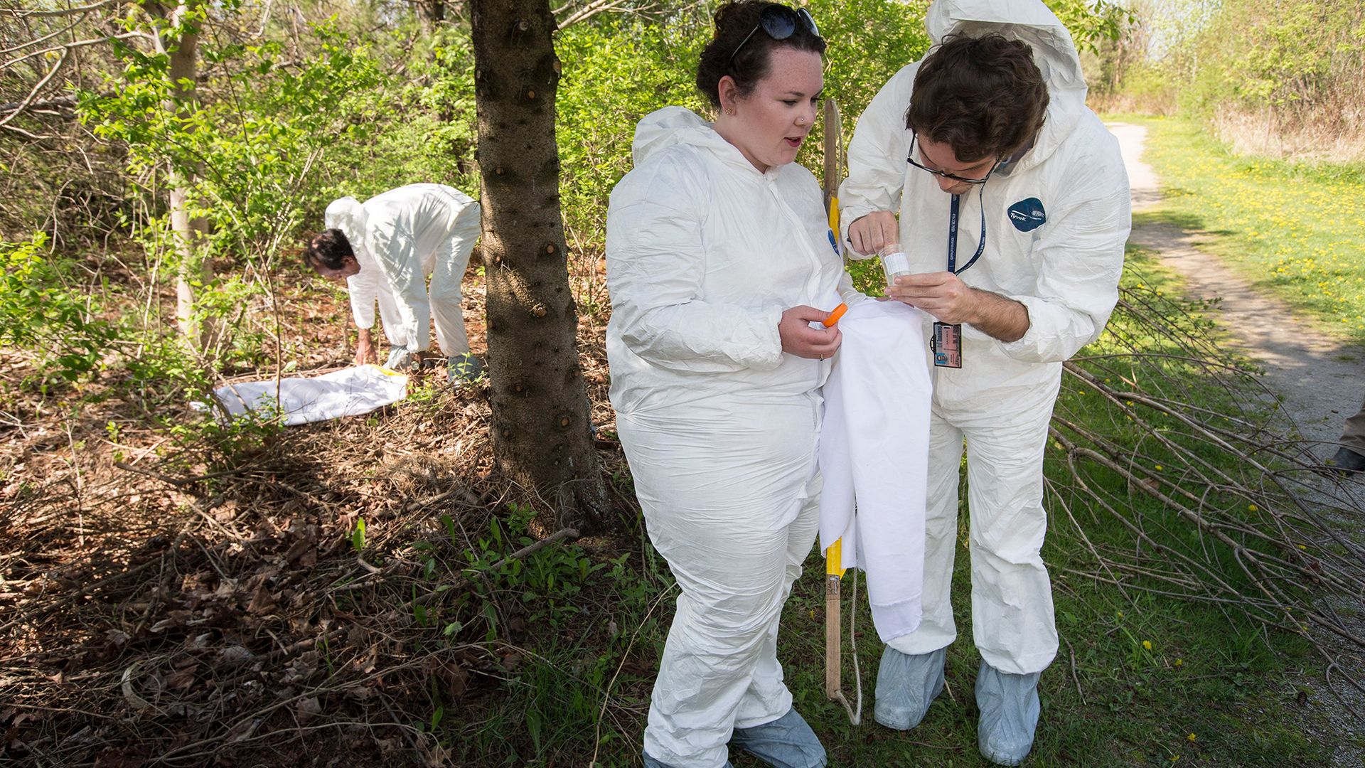
Public health workers in Ontario do a survey for black-legged ticks. Lyme disease, which is carried by the ticks, is spreading in new areas as the climate warms. (Image credit: Bernard Weil via Getty Images)
As a result, vector-borne illnesses such as Lyme disease (spread by black-legged ticks in the Ixodes genus) and West Nile virus (spread by mosquitoes) will become more common in increasingly northerly locations. Already, alpha-gal syndrome, which is not an infection but is transmitted by the Lone Star tick (Amblyomma americanum) and causes an incurable allergy to red meat, is also seeing a dramatic rise as the species expands its range across the Northeast. Positive tests for antibodies to the alpha-gal molecule have increased by 100 times between 2013 and 2024.
Right now, almost half a million people are treated for Lyme disease each year, and the CDC records more than 8,000 cases of other tick-borne diseases annually across the country. It's not clear how this will change as the climate warms. One 2022 study found major increases in Lyme disease only at levels of warming of 6.3 to 9.9 degrees Fahrenheit (3.5 to 5.5 degrees Celsius) by 2100, but that much warming that fast is now considered an implausible scenario. However, the researchers saw a huge amount of uncertainty in the numbers, given the number of variables that affect whether a spreading tick population will transmit more disease, such as how often people go outside or what steps they take to avoid tick bites. Tick-borne illnesses are likely also underreported, so even the true number of illnesses transmitted each year right now is unknown.
But ticks are responsible for spreading 90% of all vector-borne diseases in the U.S., so any trends in the suite of illnesses spread by ticks are likely to affect thousands to tens of thousands of people.
An even more ubiquitous bloodsucker, the mosquito, currently spreads only a few diseases in the U.S. The most common and most serious is West Nile virus, which mosquitoes catch from feeding on infected birds. As of Sept. 8, 504 cases of West Nile virus had been reported in the U.S. in 2026, with 363 of them affecting the central nervous system. And because fewer than 1% of West Nile cases progress to the central nervous system, those numbers likely represent a dramatic underreporting of milder cases, which can cause months of fatigue in some people, in addition to acute flu-like symptoms, such as fever, headache and body aches.
Mosquito-borne illnesses like West Nile are expected to spread more quickly in warming temperatures. Heat helps mosquitoes stick around longer during the year, much like it does for ticks. It also speeds up the transmission and replication of the virus inside the mosquito, since the insects are cold-blooded and thus their metabolism is ruled by the weather.
"Except for places that are already really, really warm, we should expect that the replication rate of the virus inside the mosquito will speed up," said John Drake, director of the Center for the Ecology of Infectious Diseases at the University of Georgia. "That shortens the generation time, and that means we expect there to be more transmission."
Even though mosquitos love water, climate-related drought could ironically nearly triple the number of human West Nile cases in the U.S. over the next 30 years from around 2,000 reported cases (according to CDC data) to between 5,000 and 6,000. That's likely because in drier conditions, more mosquitoes are infected, possibly because birds, the intermediate host of the virus, either congregate more closely with mosquitoes around water sources or breed less readily in drought, meaning the fraction of birds that carry the virus is higher than in more water-abundant times.
Except for places that are already really, really warm, we should expect that the replication rate of the virus inside the mosquito will speed up. That shortens the generation time, and that means we expect there to be more transmission.
John Drake, director of the Center for the Ecology of Infectious Diseases at the University of Georgia
Mosquito-borne diseases long ago eradicated from the U.S. could also resurge with warming temperatures. The southeastern United States will become more prone to malaria and dengue fever transmission under all levels of warming; summer 2026 saw more than 40 locally-acquired cases of dengue fever in Florida. Public health surveillance and disease-control measures have largely stopped those transmission chains, but the likelihood is that society will have to pour more money into beating these diseases back again in future decades. For example, there are malaria vaccines approved for children, but currently, they are recommended only in areas where the illnesses are endemic. If malaria were commonly found in the southern U.S., millions of Americans might need vaccines, including susceptible adults.
"If we were to get endemic diseases like those in the U.S. again, it could become a huge burden and it could be quite costly," Drake said.
Disaster and disease
Flooding is another factor that's exacerbating vector-borne disease under climate change. As climate change worsens, extreme weather events will, too. Because warm air can hold more moisture, many areas will see increased episodes of heavy rainfall and hurricanes will become more intense.
"Flooding creates habitat for these mosquitoes," Drake said.
Disasters also spur the spread of other diseases that are usually quite rare in the U.S., such as leptospirosis, a bacterial infection that spreads from animals to humans via animal urine. Floodwaters may be contaminated by the bodies of drowned animals; in 2022, after Hurricane Fiora hit Puerto Rico, leptospirosis cases leapt by a factor of 3.6 to over 10 cases a week.
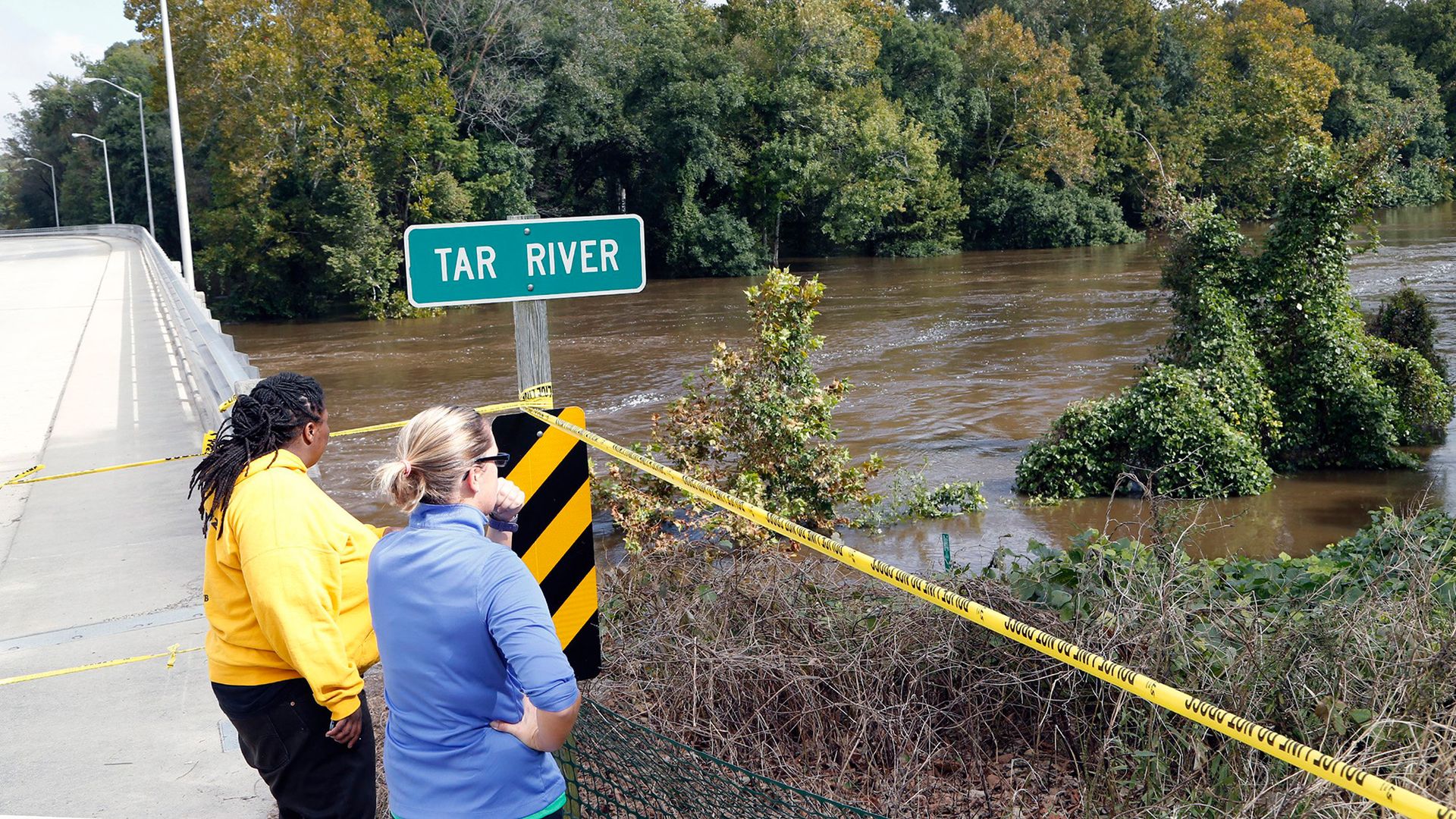
After Hurricane Matthew, emergency visits for gastrointestinal disease increased 11%. (Image credit: Raleigh News & Observer via Getty Images)
After Hurricanes Matthew and Florence in 2016 and 2018, respectively, North Carolina saw an 11% increase in emergency department visits for gastrointestinal illnesses. Black and American Indian residents were the most affected, likely because discrimination over generations has disproportionately pushed Black Americans and Native Americans to less desirable, more flood-prone land, the researchers found.
Cycles of precipitation, drought and subsequent dust storms can spur the spread of Valley fever, a fungal respiratory disease that causes an estimated 700 to 1,100 deaths per year, mostly in the U.S. Southwest. Valley fever is already on the rise, with cases in Arizona, one of the hotspots for the disease, doubling from about 64 cases per 100,000 people in 2005 to 145 cases per 100,000 people in 2022. As the West warms and dries, Valley fever is likely to spread from its stronghold in the Southwest and become endemic in Idaho, Wyoming, Montana, Nebraska, South Dakota and North Dakota, putting millions more people at risk.
The infectious disease risk from natural disasters tends to stack on top of other health problems stemming from these catastrophes. Flooded buildings can harbor mold that can worsen allergies, asthma and other respiratory illnesses. When major storms cause power loss, people turn to generators for electricity, which release pollutants linked to asthma. Though it's often hard to track the effects of these disasters, one study found that flooded regions after Tropical Storm Imelda in Texas in 2019 saw 10% more emergency department visits for asthma than nonflooded regions did.
Moreover, the threat to life and livelihood from these disasters can cause mental health conditions, such as post-traumatic stress disorder, Romanello said. The problems compound on each other, she said; already, she has heard reports from Africa about malaria outbreaks, fed by warming, and health workers struggling to reach the affected regions because flooding, also exacerbated by warming, has washed out roads.
"What is the most concerning aspect is that all of that is happening together, so we're seeing all of this risk being exacerbated at once," she said.
Jace White of Fresno acquired Valley Fever while working on his family farm. Valley fever is predicted to become more common with climate change. (Image credit: The Washington Post via Getty Images)
Antibiotic resistance on the rise
As Newman and Shan's work shows, as spots around the U.S. face new infection risks, existing treatments may become less effective. Their work showed that drought concentrated the natural antibiotics that bacteria make in the soil, making it harder for bacteria susceptible to the compounds to survive. As a result, the microbes with genes for antibiotic resistance did better. The problem for human health is that bacteria are very good at gene swapping, so these soil microbes can easily pass their antibiotic resistance superpowers to bacteria that infect people, their research showed.
"Gardening, breathing dust — that's how it happens," Newman said of human and soil bacteria coming into contact. "We are constantly encountering bacteria in our environment."
A scanning-electron microscope image of Pseudomonas aeruginosa. Recent research suggests that drought could fuel the rise of drug-resistant versions of such pathogenic bacteria. (Image credit: CDC/SCIENCE PHOTO LIBRARY via Getty Images)
The researchers found an association between drought and antibiotic resistance reported by hospitals.
They aren't the only ones. A recent study on Salmonella, a bacterium that causes about 1.35 million cases of food poisoning each year in the U.S. alone, found that temperature and rainfall promote antibiotic resistance in this microbe. "Globally, climate change was linked to about a 10% increase in Salmonella resistance gene abundance," said study first author Zhen-Chao Zhou, an ecology researcher at the Chinese Academy of Sciences in Beijing. Other microbes show similar effects.
Meanwhile, warmer conditions help bacteria grow faster, adapt to stress and swap resistance genes, Zhou said, while drought concentrates them in limited water sources where they mingle freely. Climate-change-induced flooding can then, in theory, spread the resistant genes far and wide.
Combating the compounding risks requires both public health and climate mitigation approaches, experts say. Not only does the world need to cut greenhouse gas emissions, but people also need to use antibiotics more carefully, Zhou said; improve sanitation practices, such as sewage management, around the world so that antibiotic-resistant strains don't spread as easily; strengthen food safety; and expand disease surveillance. The public also needs to understand that climate change is a health issue, Romanello said.
"When we talk about tackling greenhouse gas emissions," she said, "what we're talking about is a sustainable livable future with healthy economies."
Abnormally high temperatures on the Tibetan Plateau triggered two catastrophic rainfall events halfway around the world in California and nearby states in early 2017 and 2023, a new study reports.
This is the first time that researchers have identified this link, known as a climate teleconnection. The results could improve forecasts of extreme weather in the western U.S., which, in turn, could improve warnings for coastal communities and potentially save lives as well as billions of dollars in property damage, the study's authors say.
In December 2016 and February 2023, the Tibetan Plateau was warmer than usual for these times of the year. Roughly one month after each of these hotspots appeared, parts of California, Nevada, Oregon, Utah and Arizona received record-breaking precipitation, causing a total of around $6.6 billion in damage, according to the study, and killing at least nine people.
State-of-the-art forecast systems, which rely heavily on ocean conditions like El Niño, failed to predict this extreme rainfall, said study first author Yongkang Xue, a distinguished professor of atmospheric and oceanic sciences at UCLA. The record precipitation occurred during La Niña years, which are typically associated with dry conditions in California and neighboring regions, further complicating the picture.
"This study provides the first evidence from observational data analysis and model simulations that abnormally high early-winter temperatures on the Tibetan Plateau led to stronger atmospheric rivers along the U.S. Pacific Coast, driving heavy regional precipitation," Xue told Live Science in an email.
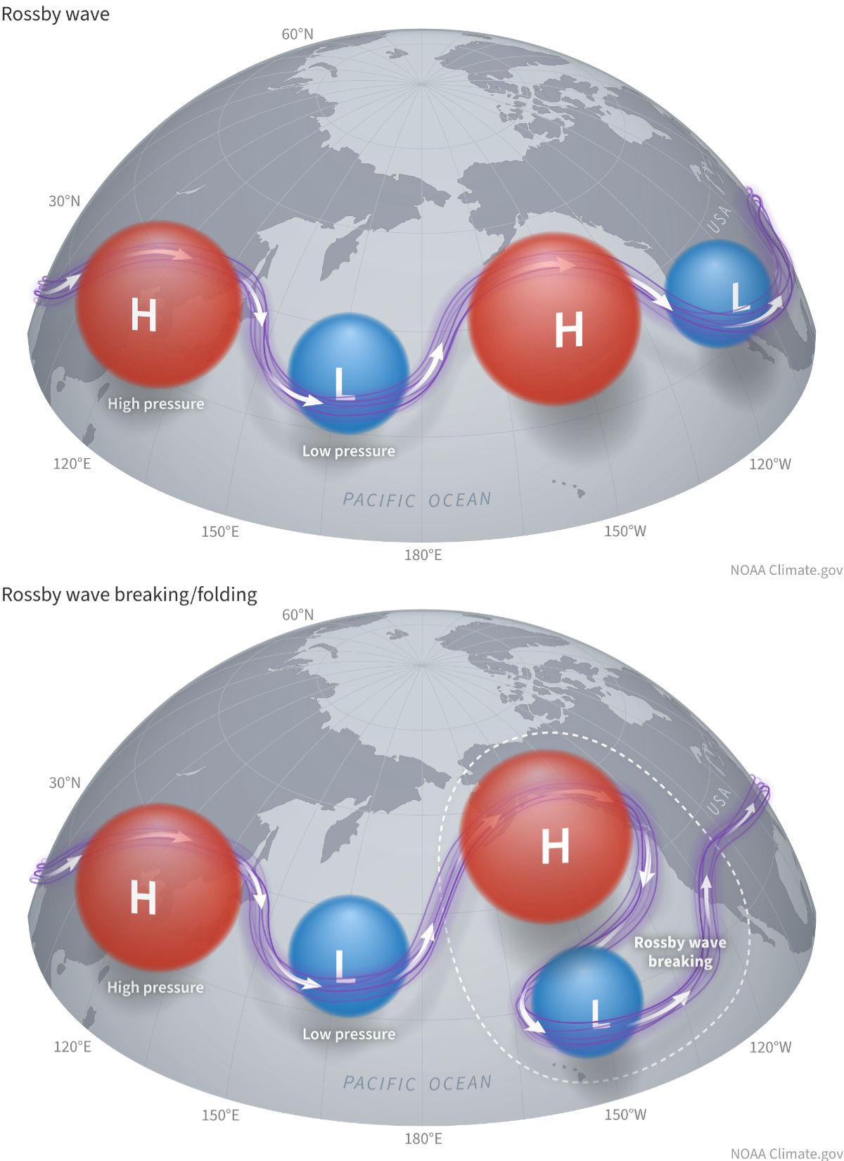
Atmospheric rivers are narrow, elongated corridors of intense water vapor transport. They are key drivers of precipitation and floods in the western U.S., and in this case, they interacted with giant waves in Earth's atmosphere, called Rossby waves, to produce devastating rainfall in the winters of 2017 and 2023.
As temperatures increased over the Tibetan Plateau in late 2016 and early 2023, a strong gradient formed with the regions north and south of the plateau. This generated an atmospheric disturbance that propagated eastward along the jet stream via Rossby waves, triggering what is known as a Rossby wave train between the Tibetan Plateau and the Rocky Mountains, Xue said.
Rossby waves are waves in Earth's atmosphere that wrap around high- and low-pressure systems. When there is an atmospheric disturbance, it can propagate in what is known as a Rossby wave train. (Image credit: NOAA Climate)
A Rossby wave train is a series of waves traveling in the same direction and at regular intervals around alternating high- and low-pressure systems. As the wave trains initiated over the Tibetan Plateau reached the northeastern Pacific Ocean, they suddenly broke, and this supercharged the weather above California and adjacent states, Xue explained.
"Over the eastern Pacific, the wave breaks — much like a towering ocean wave crashing near the shore," he said. "This wave-breaking mechanism reduces static stability and significantly intensifies atmospheric rivers, ultimately driving extraordinary, heavy precipitation along the West Coast."
The findings, published Wednesday (Sept. 9) in the journal Science Advances, are based on complex modeling and analyses of precipitation and surface temperature data, among other observations. The results are part of a new body of research examining the influence of land temperatures on weather patterns, and this is the first study of a winter season, Xue said.
The analysis is a "very specific and impactful case study," said Matthew Huber, a professor in the Department of Earth, Atmospheric, and Planetary Sciences at Purdue University in Indiana, who was not involved in the research. The results build on the well-established idea that extra heat on a mountaintop affects Rossby waves almost as if the mountain had suddenly grown, Huber told Live Science in an email.
Large mountains and plateaus generate waves in the jet stream that are thousands of miles long — "so long that we also call them planetary waves," Huber said. An increase or drop in temperature so high up above sea level adds or subtracts from the atmospheric disturbance that already exists due to the elevation.
"You can imagine the waves in the jet are kind of like a motorcycle rider going off a jump," Huber said. "How far and how high they jump depends on how fast they are going and how big a ramp they are going over."
The models replicated the extreme weather with surprising accuracy, raising hopes that the Tibetan Plateau could be integrated into early warning systems for the western U.S., Xue said. "As similar, though less severe, events become more [frequent] and extreme weather escalates globally, understanding this teleconnection allows forecasting agencies to better warn coastal communities of impending extreme conditions," he said.
Huber agreed that the results could help to better prepare for weather hazards. "This study shows that accurate predictions of weather events in the U.S. West are very sensitive to tiny changes very far 'upstream' and these upstream features are identifiable and traceable," he said.
In this excerpt from "The Carbon Wave" (MIT Press, 2026), author Leah Stokes, an associate professor of environmental politics at the University of California, Santa Barbara, looks at a hopeful moment in U.S. politics when climate change took center stage: when Rep. Alexandria Ocasio-Cortez and Sen. Ed Markey ramped up calls for a "Green New Deal."
In September 2017, a still-unknown Alexandria Ocasio-Cortez watched as Hurricane Maria devastated Puerto Rico. Electricity went down for months. Like thousands of Puerto Ricans, her grandfather died in the storm's aftermath. She could see how climate change was hitting her community harder than others.
And it wasn't just Ocasio-Cortez's community: the year before, she'd traveled to Standing Rock, North Dakota, to see firsthand how the fossil fuel industry was harming Indigenous people. It was mere weeks after the 2016 election, and the resistance to Trump had found its center in a makeshift camp along the Missouri River. People had united to oppose an oil pipeline.
Serendipitously, the day after Ocasio-Cortez left the protest, a progressive organization reached out to ask her to run for Congress. Moved by the activists at Standing Rock, she said yes. In 2018, she ran a long-shot primary campaign in a Bronx district occupied by a ten-term congressman in House leadership. Her platform included an idea that some had bandied about before, but no one had developed in earnest: a Green New Deal. As she told journalists that summer, "The Green New Deal we are proposing will be similar in scale to the mobilization efforts seen in World War II or the Marshall Plan. We must again invest in the development, manufacturing, deployment, and distribution of energy, but this time green energy." In June, she won the primary. Her election signaled the beginning of a broader shift: climate change was back on the political agenda.
That fall, the world's leading climate science organization, the Intergovernmental Panel on Climate Change — often called the IPCC — released a short report concluding that limiting warming to 1.5°C would require emissions to fall by almost half by 2030. The news ricocheted around the world, with headlines like "We Have 12 Years to Limit Climate Catastrophe." In my own neighborhood, someone printed a copy and stuck it in the free lending library, labeling it "important reading." The report changed how many people thought about the problem: it wasn't something we could deal with in 50 years; it was something we had to deal with today.
In the November 2018 midterm elections, two years into the first Trump administration, Democrats won big, paving the way for Nancy Pelosi to return as Speaker of the House after eight years as the minority leader. Days later, a group of young activists from the Sunrise Movement staged a sit-in at her office. Their bright yellow and black signs read "We have 12 years. What’s your plan?" referencing that scientific report.
Protestors from the Sunrise Movement in the office of former U.S. Representative Nancy Pelosi supporting the Green New Deal. (Image credit: SOPA Images/Getty Images)
Newly elected Representative Ocasio-Cortez joined the action that day. She told the organizers they needed a clear ask and encouraged them to call for a Green New Deal. The idea broke through, sparking widespread coverage across the country. It was a new, hopeful vision for climate policy. These young people were not just talking about the climate disasters we needed to avoid — they were explaining how investments in clean energy could create good jobs. They were showing us the better world we could build together. If we only tried.
I watched these developments unfold in DC from my office by the Pacific Ocean and wanted to be a part of it. I wouldn't have to wait long. The Green New Deal held a force like gravity, pulling people into its orbit. By chance, I met some of the people tied to Ocasio-Cortez at a conference and was invited to an early gathering to develop the idea into more detailed policy. By then, she'd released a framework for the plan with Senator Ed Markey of Massachusetts.
The meeting was held in March 2019, at a hip hotel in DC's Adams Morgan neighborhood, miles away from the Capitol. A wide swath of people were invited: youth activists, environmental justice leaders, political organizers, think tank wonks, and a few academics like me. It was a contentious meeting that opened with a protest, revealing fissures in the movement that would eventually grow into large cracks. Some people believed that frontline communities facing the greatest pollution burdens were not being adequately consulted or invited to participate in the event. At the time, I didn't understand these dynamics between the climate and environmental justice movements. I was just a political science professor trying to understand how I could make my work more practical and help get a climate law passed if we got the chance.
Varshini Prakash speaking during a Climate Strike rally in New York Citiy in 2019. (Image credit: Pacific Press via Getty Images)
It was at that event that I met Varshini Prakash, the executive director of the Sunrise Movement. I’d seen her photo many times, standing in the middle of Pelosi's office with her dark red jacket over a black and yellow T-shirt, surrounded by young people sitting on the floor. Four months had passed since the sit-in, and Varshini had ricocheted to the center of the climate movement. But she was also a recent college grad in her mid-twenties, feeling a heavy burden from the climate crisis and the work involved in fighting it. At one point during the meeting, she spoke frankly about the stress that was on her and other young activists and cried. I found her vulnerability moving.
The fact was, Varshini had already changed history. She'd given me, and millions of others, a sense of hope and possibility. It was her actions, alongside all the other organizers in the Sunrise Movement, that brought us together in that first DC convening, and in countless other meetings to come. She inspired me to believe that I could do something bigger if I tried.
Too often, the way we think about cause and effect is simplistic. We're fed a linear model that favors the immediate. One person is responsible for their own carbon footprint. One person only has one vote. One person can only do so much. From this perspective, standing against more than a century of fossil fuels running through the heart of our society, it can feel like there's nothing we could do to shake the system loose. We're too small. Mere drops. But drops in the ocean can make waves.
The Carbon Wave: a Story of Democracy, Parenthood, and the Race to Protect Our Planet
Interlacing personal narratives with stories from Congress, the White House, and outside activists, Stokes shows how dogged perseverance and collective action can still bend the course of history. The book concludes with an update from the second Trump administration, explaining the parts of the bill that were—and were not—rolled back, and why we should remain hopeful that progress is still being made.
In the event of a global catastrophe, such as a nuclear war, an enormous volcanic eruption or large asteroid strike, the best place to be is Australia, according to a new study.
Researchers looked at the places that were most resilient to global catastrophic risks, which are events that would kill more than 10% of the global population over several months or years.
"These kinds of catastrophes are under-researched" because they are not very likely, study first author Florian Ulrich Jehn, a researcher at FernUniversität in Hagen, Germany, told Live Science. "That makes them easy to ignore."
But they are still possible — and no country would be unaffected if they occurred, he said. And some places are more vulnerable than others.
In the new study, published Aug. 23 in the journal Global Challenges, researchers analyzed studies across a variety of disciplines such as food security, biological weapons, and volcanism, to identify potential global catastrophic risks and the factors that helped communities to endure them in the past or on a smaller scale. They also brought in subject experts to add discipline-specific papers to their database.
The team identified three broad types of risk: events that would block out sunlight, such as nuclear war or a huge volcano explosion); events that destroy global infrastructure, such as a geomagnetic storm or massive cyber attack; and biological hazards, such as natural or human-caused infectious diseases that would kill much of the population.
These events, the authors wrote, would have significant and long-lasting global consequences. Many would result in global famine from crops failing and trade networks falling apart. "The food system is often the thing that gets you," Jehn said.
A trade-off of risks
The team identified characteristics that made countries more resilient to catastrophe and better able to feed their inhabitants. And while "no single place on Earth" would be resilient against all catastrophic risks, the authors wrote, some would fare better than others.
The team found that wealthier countries and regions with a strong industrial base that are not highly reliant on global trade are better able to weather global disasters.
With a strong industrial base, countries are able to manufacture goods that they cannot import, making them more resilient.
Geography also plays a role. Large islands have an advantage over continents because they can easily isolate, but they also need to have an economy that can at least partially support itself, the researchers said. If an island is highly reliant on international trade, like Japan, it will struggle if global trade networks are disrupted, the study found.
Certain countries and regions are less resilient in the face of some types of catastrophes, even if they are wealthy. For example, countries with nuclear capabilities, such as the U.S., the U.K., France, Israel, Russia, Pakistan, and India, are more at risk of being involved in nuclear war. This makes the Northern Hemisphere, where NATO countries are situated, more vulnerable to nuclear attack than places in the Southern Hemisphere.
There are also fewer volcanoes in the southern half of the globe, while the Southern Hemisphere has more ocean to act as a climate buffer, making countries there more resilient to a huge volcanic eruption, the study found.
Findings showed Australia is the best place to survive an apocalyptic event. (Image credit: omersukrugoksu via Getty Images)
Global resilience
There are some factors that make all countries better able to endure disasters in general, such as democratic processes and equality, Jehn said.
"When these catastrophes happen, you have to make the right decisions, and this depends on whether your country has functional governance," Jehn said. "Inequality makes governance worse, because it leads to things like elite rivalries, or less state capacity."
Australia came out as the best location to weather a catastrophic event that decimated global populations. It is in the Southern Hemisphere, so far away from the most likely location of a nuclear conflict (although the authors warn that it is allied with the U.S., which might increase its risk exposure). It is a major food producer, with diverse climatic zones, and has significant energy infrastructure.
Next best spots are Argentina, Brazil and New Zealand. New Zealand ranks lower than Australia because it has active volcanoes, a small industrial base, and is surrounded by water and vulnerable to tsunamis. Meanwhile, Brazil and Argentina have high levels of inequality and historical political instability, the authors wrote.
They also note that Iceland was a contender for a safe refuge, but its location in the far north makes it vulnerable to temperature shocks if a major incident were to block out sunshine.
The U.S. is not particularly well-placed to weather a global catastrophe, the study found. The country is exposed to the threat of geomagnetic storms because of its location and to nuclear war. The authors also pointed to the country’s poor COVID-19 outcomes, which appeared to be due to "a lack of political will and poor social cohesion."
David Denkenberger, director at Alliance to Feed the Earth in Disasters (ALLFED) and a researcher at the University of Canterbury in New Zealand, told Live Science that the new study aids our understanding of future risks by considering a wider range of catastrophes.
"No country is resilient to every catastrophe, and this is an important central finding," he said. "A useful next step would be to quantify the relative likelihood and severity of different catastrophes, and the importance of different resilience factors, because these factors can involve significant trade-offs," said Denkenberger, who has previously collaborated with Jehn but is not an author on the paper.
Even though these global catastrophes are unlikely, it is important to include them on national risk registers and have international trade agreements in place in case they come to pass, Jehn said. "When global catastrophes happen, then you would likely have to restructure the food system — where it is produced, where it is traded," he said. "The chance to find a good compromise after the catastrophe has happened seems slim."
Denkenberger echoed his comments. The study, he said, "makes it clear that regional resilience to global catastrophic risk requires investment in practical preparedness, including food-system resilience, critical infrastructure, coordinated trade and governance."
Two distinct climate regimes that could trigger runaway methane emissions are emerging in Siberia due to Arctic warming, new research suggests.
While western Siberia is becoming wetter in response to rising heat and moisture transported from the North Atlantic Ocean, eastern Siberia is getting drier and more prone to wildfires, a study published Aug. 6 in the journal Science finds. The Yenisei River (also spelled Yenisey) in central Russia delineates the separate environmental states — referred to as regimes because they describe specific types of climates — on each side of the basin, the study authors said.
Between 2010 and 2023, methane emissions from Siberia rose by 5% per year, with western Siberia releasing methane mainly via microbial activity in thawing soils and eastern Siberia discharging the powerful greenhouse gas through biomass burning, the results showed.
"Given the observed increases in permafrost thaw, wetland activity, and wildfire occurrence, an increase in methane emissions was expected," study co-author Paul Palmer, a professor in the School of Geosciences at the University of Edinburgh, told Live Science in an email. "What is surprising is how large and sustained the increase appears to be."
Annual methane emissions grew by about 13.2 million tons (12 million metric tons) over the study period, almost mirroring the rate of increase in methane emissions from wetlands worldwide. Although Siberia currently makes up only about 5% of global methane emissions, the region is becoming one of the fastest-growing natural methane sources on the planet, Palmer said.
In their study, Palmer and his colleagues integrated satellite observations with near-surface measurements to map methane emissions from Siberia over time. Instead of adding up individual methane sources on the ground, the researchers used a modeling method known as a methane flux inversion system, which helped them limit the uncertainty in their estimates to roughly 10%.
Siberia is vast, remote, sparsely instrumented and currently inaccessible for many scientists due to the Russia-Ukraine war, making it hard to monitor methane consistently by any means other than satellites. Although satellites rely on sunlight, of which Siberia gets very little in the winter, most methane emissions are thought to occur in the spring and summer, when Siberia gets more sunlight, Palmer said.
The results of the study show that Arctic warming amplifies methane emissions via distinct pathways in western and eastern Siberia because the regions are influenced by different climate patterns. The researchers also used climate models to predict future methane emissions from Siberia and found that additional warming could unleash millions of tons of greenhouse gases stored in forests and permafrost, which would further accelerate the warming trend.
In western Siberia, methane is released mainly from permafrost, or ground that has stayed frozen for at least two consecutive years. Siberia holds 46% of the Northern Hemisphere's permafrost, and this icy sediment traps vast amounts of carbon that have accumulated for thousands of years, Palmer said.
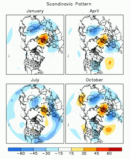
Western Siberia is influenced by the Scandinavian pattern of atmospheric circulation, a climate connection that consists of a main circulation center over Scandinavia and opposing weaker centers over Western Europe and eastern Russia. Global warming makes the Scandinavian pattern transport more warmth and moisture to western Siberia from the North Atlantic. Together with soaring temperatures in western Siberia itself, this triggers extensive permafrost thaw and unlocks carbon that microbes can convert into methane.
The Scandinavian pattern of atmospheric circulation (seen here in the positive phase) consists of different pressure systems above Scandinavia, Western Europe and eastern Russia/western Mongolia. (Image credit: NOAA)
Conversely, eastern Siberia is influenced by a climate pattern known as the Arctic Oscillation, which causes atmospheric air pressure to "seesaw" between the Arctic and the Northern Hemisphere's middle latitudes. Climate change affects the Arctic Oscillation, leading to persistent high-pressure systems that intensify heat waves, reduce cloud cover and promote wildfires in eastern Siberia, Palmer said.
The climate models showed that methane emissions will increase with temperature rise and that the increase could become steeper the hotter the world gets, triggering a feedback loop.
"Eastern Siberia appears to be the main driver of the projected increase because it is warming faster than western Siberia and has seen a sharp rise in extreme wildfires," Palmer said. "Whether that trend continues will depend on how much vegetation remains available to burn, but there is also evidence that fires may be accelerating permafrost thaw and the release of methane from previously frozen ground."
However, the rise in methane emissions reported in the study is small relative to global and projected future emissions, especially if wildfires are already destabilizing eastern Siberia's permafrost, Palmer said.
"Siberia's vast permafrost carbon store is a sleeping giant," he said. "Continued warming risks waking up a much larger source of greenhouse gases."
What's in the photo? A massive plume of smoke blowing from Manhattan in the wake of 9/11
Who took the photo? NASA astronaut Frank Culbertson, on board the ISS
When was it taken? Sept. 11, 2001
This iconic photo, captured by an American astronaut on board the International Space Station (ISS), shows a lengthy trail of thick smoke pouring across New York City in the immediate aftermath of the 9/11 attacks. A quarter of a century later, the image is as haunting as ever.
On the morning of Sept. 11, 2001, members of the terrorist group al-Qaeda hijacked four passenger airliners and crashed two of them into the twin towers — a pair of 110-story skyscrapers at the heart of the World Trade Center in lower Manhattan. The impact of these collisions, which occurred roughly 17 minutes apart, eventually caused both buildings to collapse.
Shortly after the second tower was hit, the third hijacked plane crashed into the Pentagon, the headquarters of the Department of Defense in Arlington, Virginia. Another attack — likely intended for Washington, D.C. — was thwarted when the passengers of a fourth plane fought back against their hijackers, causing the aircraft to crash near Shanksville, Pennsylvania. In total, 2,977 people were killed across the different attacks, according to the 9/11 Memorial and Museum.
NASA astronaut and ISS commander Frank Culbertson — the only American not on Earth at the time of the attacks — passed over New York City shortly after being told about what was happening back home. He photographed the thick plume of smoke blowing away from Manhattan, at an altitude of roughly 250 miles (400 kilometers) above Earth's surface.
If you look closely, you may be able to see what Culbertson described as an "odd bloom" around the base of the column of smoke rising from the towers. This is likely a sign that the image was captured "around the time of, or shortly after, the collapse of the second tower," Culbertson said.
NASA astronaut and ISS commander Frank Culbertson captured the aftermath of 9/11 from space. This photo, taken Sept. 17, 2001, shows him holding his cameras in zero gravity. (Image credit: NASA)
Culbertson wrote several letters in the days following the attacks, sharing his unique perspective of the events. "It's horrible to see smoke pouring from wounds in your own country from such a fantastic vantage point," Culbertson wrote on Sept. 13. "The dichotomy of being on a spacecraft dedicated to improving life on the earth and watching life being destroyed by such willful, terrible acts is jolting to the psyche."
While in space, Culbertson learned that the pilot of the plane that was later hijacked and crashed into the Pentagon was his former flight school classmate Charles "Chic" Burlingame. When the ISS later passed over the Pentagon, the astronauts could see the large gash in the side of the building where the third plane had crashed. "Tears don't flow the same in space," Culbertson wrote while discussing his friend.
Additional imagery — captured by the Landsat 7 satellite on Sept. 12, 2001 — shows that smoke continued to pour from Ground Zero for at least 24 hours. (Image credit: USGS/Landsat 7)
In 2017, Culbertson revealed that there was another striking thing he and the rest of his crew noticed in the wake of the attacks, according to Live Science's sister site Space.com. "One of the most startling effects was that within about two orbits, all of the contrails that are normally crisscrossing the United States had disappeared because they had grounded all the airplanes," he said.
However, there was one exception. The astronauts noticed a single contrail moving eastward across the Midwest. "That was Air Force One headed back to D.C. with President Bush," Culbertson said. It was a "very sobering" sight, he added.
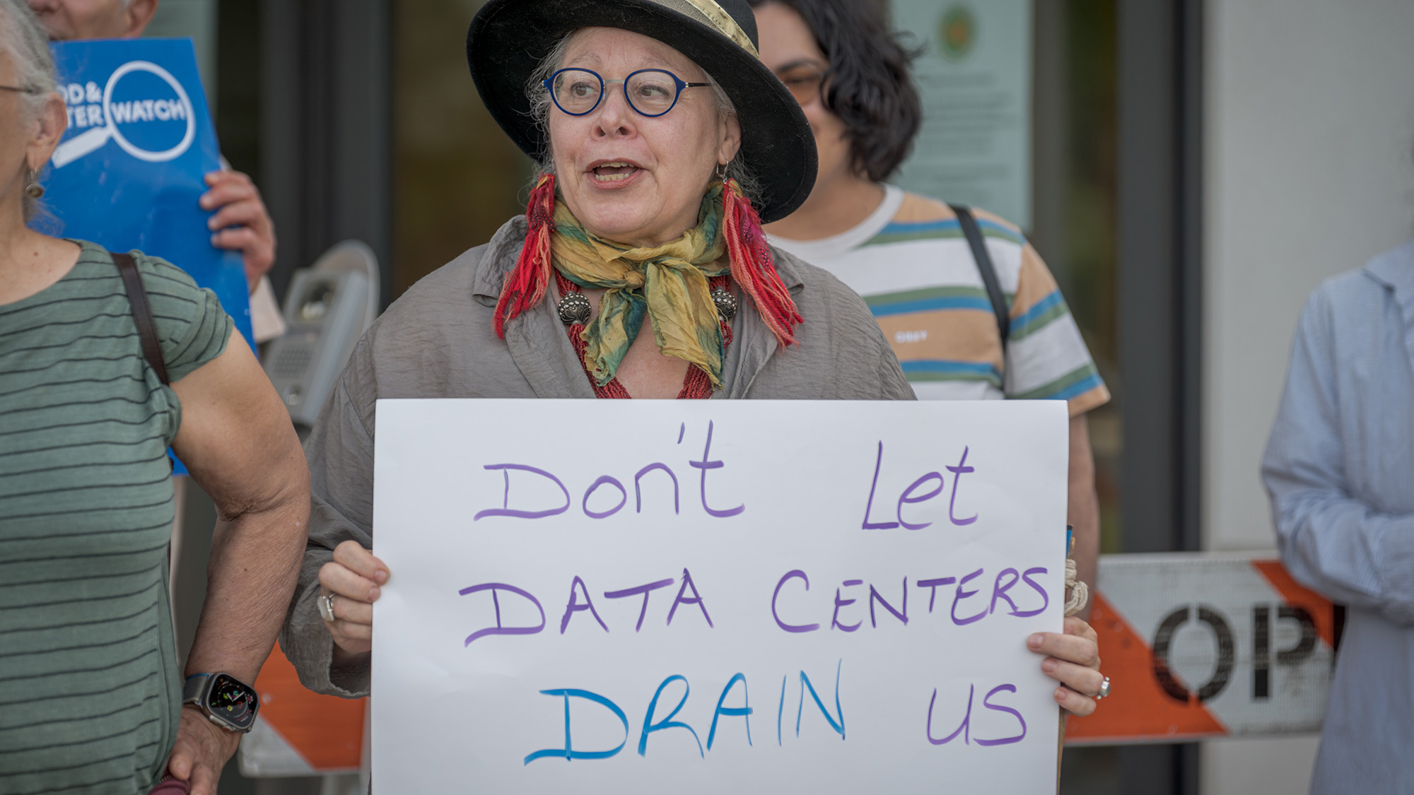
"Protect our water," "Water for people not AI," "Don't mess with our water," declare protest signs from Texas to New Mexico to Arizona. Angered by water use, energy consumption and pollution, locals are increasingly protesting the rapid expansion of data centers in the United States as tech companies work to rapidly expand capacity for AI.
Many data centers rely at least partly on water to absorb heat from air or surfaces, and then cause cooling as it evaporates, just like sweating keeps our bodies cool. The processors inside data centers can reach internal temperatures of up to 176 degrees Fahrenheit, for the same reasons that an overtaxed laptop heats up.
But while there's little doubt that data centers are consuming significant amounts of energy, water consumption is more complicated. Claims circulating online bring scant clarity, ranging from articles claiming that chatbots can consume 500 ml of water per query to some online commentators declaring AI's water issue to be nonexistent. And the consumption data from large tech companies themselves are often incomplete and inconsistent.
Experts stress that, overall, data center water consumption pales in comparison to the usage by industries likeagriculture and some kinds of manufacturing. Researchers have estimated that data center cooling systems consumed 66 billion liters of water in 2023, less than 1 percent of the nation’s total consumption.
That figure could considerably rise with the rapid buildout of AI data centers, however — which may not be a big problem for water-rich regions but could significantly add to local water stress in drought-strapped places like New Mexico and Arizona.
Fortunately, engineers say there's a host of things that can be done — and are being done — to reduce the strain on local water resources. "There are many good ideas out there," says energy systems expertFengqi You of Cornell University. When you add in efforts to replenish and restore natural water resources, "there's a good chance that, eventually, it could be net-zero water for the on-site cooling."
AI's water consumption is one reason why local communities across the United State — such as here, in New York — are protesting against the construction of data centers. (Image credit: Erik McGregor via Getty Images)
More renewable energy and better siting
Recent advances in AI technology have already reduced water demand for many data centers. Electrical and computer engineer Shaolei Ren of the University of California, Riverside, says that an estimate he made based on GPT-4, an earlier version of the model powering ChatGPT, as recently as 2024 — that drafting a short email would consume 500 milliliters of water — is already outdated because AI models have become more efficient. (This study was the origin of the half-liter-per-query claim.) In 2025, Google estimated that five drops of water are spent on processing a median-length query with its chatbot Gemini.
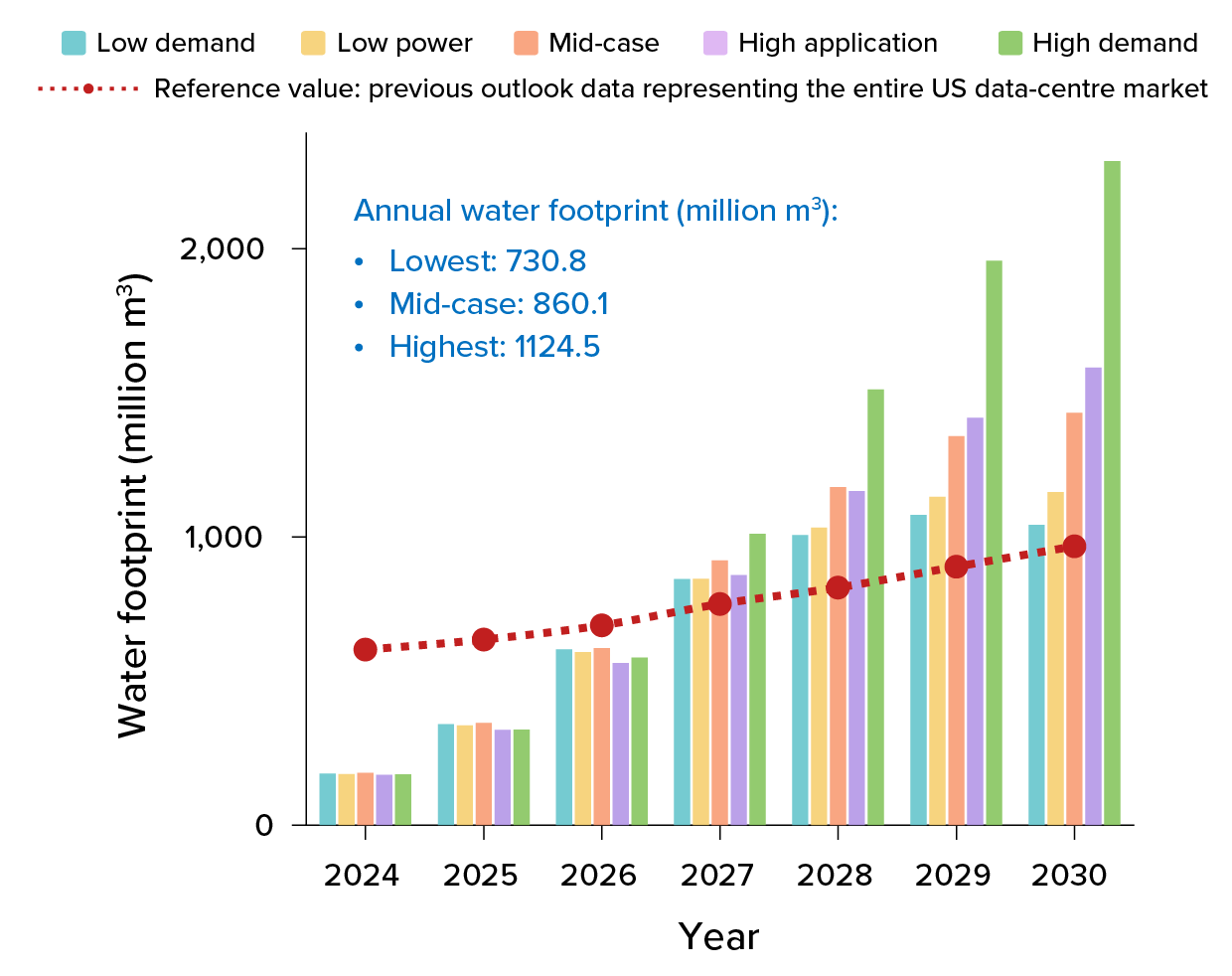
But even tiny amounts add up, given the rise in AI use. You's group recently predicted that by 2030, US data centers could consume 731 billion to 1,125 billion liters annually — the latter roughly equivalent to New York City's annual drinking water supply.
Experts predict that the use of water for cooling AI data centers, as well as for generating fossil fuel-powered electricity to run them, will rise as numbers of data centers increase. One 2025 study projected future water consumption in the United States under different scenarios and found that solutions such as shifting to renewables, improving the efficiency of AI processors and the strategic siting of data centers could significantly curb AI's water use. (Numbers in blue depict the projected average annual water footprint over the full 2024 to 2030 period under low-demand, mid-demand and high-demand scenarios.) (Image credit: T. XIAO ET AL / NATURE SUSTAINABILITY 2025)
Still, these numbers factor in not just cooling, but also a greater amount of water used to generate the electricity that powers data centers. Much of that comes from burning coal or gas, with water being used to cool steam back into liquid after it's been used to spin the electricity-generating turbines. In other words, AI's water consumption can be significantly reduced by shifting to solar and wind, which require little to no water to operate, You says.
You adds that companies should site data centers in areas less prone to drought and with ample renewable energy sources, like regions in Montana, Nebraska, parts of Texas and South Dakota, instead of constructing new data centers in water-stressed places, such as in Arizona, New Mexico and Southern California. Strategic siting along with other measures could reduce AI's future water footprint by up to 86 percent, he says.
New cooling technologies
Advances in cooling technologies are also helping. The newest data centers that specialize in AI are already more water-efficient than their predecessors.
Pre-AI data centers use fans to carry away the heat from processor-filled racks, then use chilling systems funneling cool water through the building to cool the warm air down again. The heated water is then fed into acoolingtower that removes the heat but also loses some of the water to the atmosphere. This evaporative cooling uses a lot of water, says Eric Masanet of the University of California, Santa Barbara, who researches data center sustainability.
But the energy-hungry processors inside AI data centers generate so much heat that it's hard to remove it with air alone. That’s why many tech companies — including Amazon, Microsoft and Google — use a more efficient technique called liquid cooling.
In this method, a system of pipes filled with water, sometimes mixed with temperature-regulating chemicals, runs on top of the hardware, cooling the processors directly rather than cooling the entire data center. And because this is a closed-loop system, no water is lost: The heated fluid can be cooled down by exposing the pipes to the outside air, if conditions are cool enough, or an air-conditioner-like system, which uses energy.
But when it's extremely hot or humid, the centers need to bring online extra, more effective methods that involve water; one of these is to mist the air around the pipes. Mechanical engineerVaibhav Bahadur at the University of Texas at Austin says that most AI data centers in Texas only use this kind of water-based cooling for the hottest parts of the summer.
Still, he and his colleagues recently estimated that the state's growing number of data centers — which currently consume less than a percent of the state's water demand — could be using 3 to 9 percent of that water by 2040. He expects that figure to reduce considerably, though. "Data centers are becoming much more efficient in their water usage," he says.
Indeed, recent technological developments have made it easier to avoid water-based cooling, even in hot climates, says Josh Parker, head of sustainability for NVIDIA, the company that designs many of the processors that populate AI-specialized data centers. Their latest generation of processors run at such high temperatures that they can be cooled with water at around 113 degrees Fahrenheit which,Parkersays, is significantly warmer than traditional approaches. That reduces the need to bring on water-based cooling. Unless local temperatures regularly exceed 113 Fahrenheit, a threshold generally crossed only during severe heat waves, "typically we can just get away with large efficient fans cooling the infrastructure and the ambient air is sufficient to pull the heat away," Parker says.
Ren cautions that some companies may not want to run their processors that hot because it can interfere with computational performance, while some also house non-AI servers in the same space that cannot take the heat.But other cooling technologies are in development.
Some of these rely on elaborately designed pipe systems that draw heat even more effectively from processors. A number of US companies are exploring immersion cooling, where data center hardware sits in a tank filled with cooling liquid. In China, some companies have taken a similar approach by installing data centers in the ocean, although this makes them hard to access should hardware need replacing or upgrading, Bahadur says.
Advances in cooling technology will be necessary for tech companies to meet sustainability goals they have set for their operations. According to a statement from Amazon, its Web Services"set a goal to be water positive by 2030 — returning more water to communities than our direct operations use — and as of 2024, we're more than halfway there."
Some companies, such as Google, are also finding smart ways to use waste heat from data centers to help address other sustainability challenges, such as making building heating less reliant on fossil fuels. Across Europe,some data centersare funneling heat from cooling circuits into district heating systems used to warm buildings.
The future of AI's water usage hinges on decisions that tech companies, engineers and policymakers will make in the coming years, Masanet says: where data centers are sited, their local energy infrastructure and climate, and how they're designed. "If you choose one set of choices, your number is going to be off the charts," he says. "You choose another set of choices, it's going to be way down here."
Large patches of open water were visible just 37 miles (60 kilometers) from the North Pole on Aug. 29, a NASA satellite image shows. Although this doesn't necessarily mean that Arctic ice is worse off this year than the past few years, the image reveals how severely climate change is affecting the region, experts say.
The image is from the NASA Worldview satellite photo browsing tool and was shared last week on the blog Arctic News. The patches are "quite striking," but it's not the first time that water has encroached upon Arctic ice in this way, said Julienne Stroeve, a professor of polar observation and modeling at University College London.
"We can see open water at times at the North Pole but I don't think it's ever been this extensive," Stroeve told Live Science in an email. For instance, the central Arctic Ocean and regions north of 80 degrees north latitude, an imaginary line that crosses Canada's Ellesmere Island and Spitsbergen in Norway, were highly fragmented in early September 2016.
The time of year is one reason water is now visible in this region, said Zachary Labe, a climate scientist at Climate Central, a nonprofit news organization that analyzes and reports on the climate. "By the end of summer, the sea ice generally becomes more fragmented, with areas of open water appearing more widespread between pieces of sea ice," Labe told Live Science in an email.
This means that local weather conditions and ocean currents can create large gaps between ice floes, Labe said. For example, strong winds can push ice fragments together or pull them apart, leading areas of water to widen or close within hours or days.
"Individual satellite images from around the North Pole in just the last two weeks show dramatic changes in the amount and location of visible open water," he noted.
The current extent of Arctic sea ice isn't particularly low when compared with record-setting years, but that's now very changeable due to the diffuseness of the ice, Stroeve said. "Winds could change and compress the ice into a more compact ice cover leading to sudden drops in total extent," she said.
There is no specific distance from the North Pole at which open water should normally stop, because Arctic conditions can vary substantially from year to year, Labe said. However, the summer ice has become thinner and more fragile in recent years, so open water is consistently reaching closer to the North Pole than it did before.
"To me, this image doesn't necessarily show that conditions are dramatically worse this year compared to other recent years," Labe said. "Instead, it represents a worrying snapshot of a very different Arctic Ocean than only a few decades ago and one that is quickly changing over time."
The Arctic is warming nearly four times faster than the global average. Some of the northernmost regions that have historically boasted expansive, thick and persistent ice at the end of summer now have young, brittle ice floes instead, Labe said.
"The broader implications of more open water across the Arctic Ocean are wide-ranging, from changes in local weather and ocean conditions to impacts on marine ecosystems and greater coastal risks like erosion and flooding for Arctic communities," he said.
Scientists expect that sea ice will start to refreeze by mid- to late September, closing at least some of the gaps.
As the planet warms, our environment will be transformed, but so will our bodies. In this series, we investigate the health impacts of climate change, focusing on heat, air quality, food and infection risk. We also evaluate the promising solutions that could help us adapt to our warmer future.
With only a couple of months to go before the harvest season for winter wheat in Colorado, the crop faced a whiplash: After a warm, dry winter, a cold snap plunged the plants into freezing weather for 12 hours, and temperatures soared to nearly 90 degrees Fahrenheit (32.2 degrees Celsius) two days later. When the final harvest numbers were tallied in July, 73% of the crops were in poor or very poor condition. According to early estimates by Colorado Wheat, 2026's winter wheat crop was the smallest in the state since 1965.
Pick a crop, any crop, and you'll hear a similar story: Extreme weather and climate change are rocking the food supply. The warming climate makes food less nutritious, threatens crop survival, and triggers tipping points that would upend farming as we know it.
The impacts will be felt most intensely in less-developed regions of the world, where many people can't afford imported food and climate-related famines and nutritional scarcity are already happening.
Climate change is threatening farming around the globe. (Image credit: Jason Edwards/Getty Images)
But the U.S. is facing big changes to its food systems too, and no one is immune. Humans have overcome looming agricultural disasters before, but experts say the challenge should not be underestimated.
"There are real food security and nutrition concerns," said Andrew Hultgren, an environmental economist at the University of Illinois, Urbana-Champaign, "especially under these high-warming futures."
Food is becoming less nutritious
As the planet warms, food crops are expected to become less nutritious. That's because, due to plant biology that's not yet fully understood, crops grown under higher levels of carbon dioxide are deficient in zinc, protein, magnesium, iron and other micronutrients.Crops are already less nutritious than they were in the 1950s, but this is partly due to breeding decisions that prioritize yield over nutrition. The carbon dioxide deficiencies will exacerbate this nutrition decline.
The global monthly average concentration of carbon dioxide in the atmosphere is now over 420 parts per million (ppm), well over the preindustrial average of 280 ppm. By the end of the century, those levels will increase to at least 550 ppm in all but the most optimistic scenarios.
That will mean an additional 175 million people will be zinc deficient and an additional 122 million people will be protein deficient by 2050, a 2018 study found. Zinc deficiency has consequences for immune and skin health and may lead to poor growth in childhood; protein deficiency can also cause stunted growth as well as fatigue, muscle weakness and stress fractures. Those figures account only for the effects of carbon dioxide. A cascade of climate shifts and extreme weather may also affect the number of nutrients (and calories) available to the world.
The threats are myriad: Rising sea levels may inundate farmland and lead to saltier soil in coastal regions where, for example, rice farming is common. Soil salinity can make it impossible to grow crops in some regions. Droughts, heat waves, storms or temperature swings like those seen in Colorado this year might take out certain crops in particular places, leading to year-by-year price spikes or shortages. In the U.S., the results might look a lot like the recent egg shortages triggered by bird flu; temporarily empty shelves, price spikes, or even restrictions on the amount a customer can purchase in a visit for an affected food.
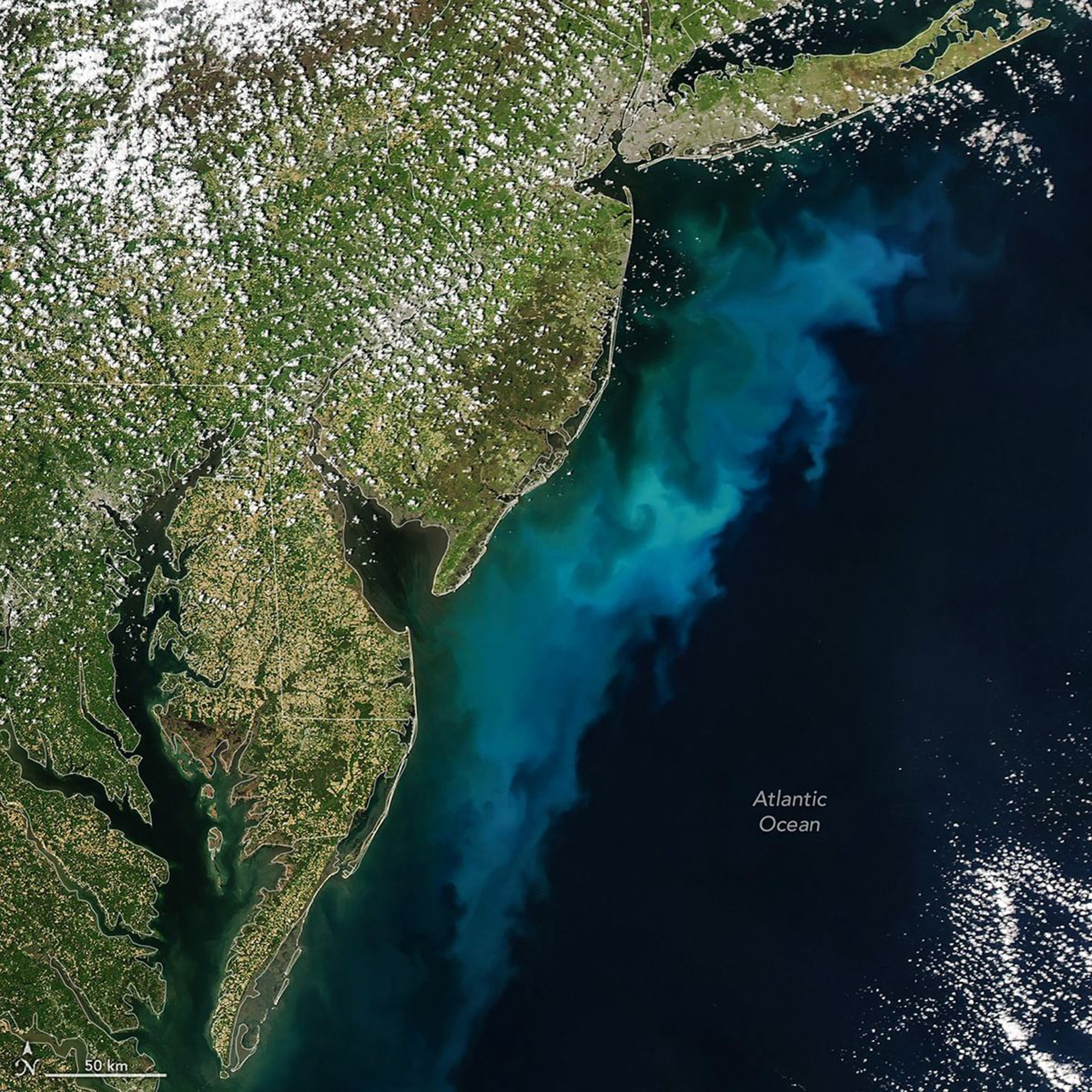
Phytoplankton blooms, like the one that grew off the Atlantic coast in April, can make seafood toxic. Such blooms will become more common as climate change worsens. (Image credit: NASA Earth Observatory/Michala Garrison)
Climate shifts that harm pollinators and fuel the spread and introduction of plant pathogens such as harmful fungi will also likely reduce crop yields.
Areas that depend on the ocean for food are also facing steep challenges, due to both ocean acidification and the degradation of coral reef ecosystems, which are sources of food for many coastal communities and form much of the base of food chains for the larger fish people eat.
Hotter weather also affects food safety, said Christopher Golden, a professor of nutrition and public health at the Harvard T.H. Chan School of Public Health.
"Increasing sea temperature and increasing sedimentation within seas could lead to harmful algal blooms or increasing food poisoning events from temperature-related food spoilage," Golden said. Algal blooms can contaminate shellfish like oysters or scallops with neurotoxins that can sicken and kill people who eat them. Food spoilage is a concern in regions such as Madagascar, where catches are brought ashore and readied for consumption in the open air.
Meanwhile, fish may move poleward to avoid the hottest sea temperatures, leaving the most vulnerable regions — such as Southeast Asia, the Caribbean, Africa, Central America and the Pacific — with fewer fish in their waters. How bad this looks depends on the extent of the climate swings, with research suggesting that without any mitigation, fishers could see their catches decline by 58% to 92% off small islands in the Pacific and by 70% to 86% in Southeast Asia. This would drive food insecurity and malnutrition in those regions. The U.S. will likely face impacts too, as most of its seafood is imported from subtropical or tropical waters elsewhere.
Climate change is bad in that it's a slow-moving wave. You don't really notice that it's shifting underneath you and that the apple you eat isn't the apple your granddaughter will eat.
Elizabeth Wolkovich, professor of forestry at the University of British Columbia
There may be shifts in trade networks that lessen the blow for U.S. consumers, Golden said, but it's hard to predict. Some possibilities include "price shifts or trade shifts that lead to changing dietary patterns or more shelf-stable and heavily processed items that we know aren't good for your health," he said. In other words, less fresh-caught snapper and more potted meats.
Changing foods on the table
Individual producers are adapting, sometimes in ways that may not be immediately obvious to consumers. "Climate change is bad in that it's a slow-moving wave," said Elizabeth Wolkovich, a professor of forestry at the University of British Columbia. "You don't really notice that it's shifting underneath you and that the apple you eat isn't the apple your granddaughter will eat."
On that note, growers in the Pacific Northwest and U.S. Northeast will face challenges getting apples to lunch boxes around the world. Fewer cold days and more extreme-heat days will likely reduce apple yields by affecting how and when trees go dormant and bloom. Because it takes five or more years to establish fruiting trees in new regions, this could mean a reduced apple supply and higher prices.
Today's smooth arabica coffee (Coffea arabica) varieties may get harder to find and more expensive as climate change forces coffee growers out of many of the places they used to farm and droughts reduce supply. Earthier, more bitter robusta coffee beans (Coffea canephora) do better in warming temperatures, but even those beans could struggle with increasing seasonal variability caused by climate change.
Climate has already shifted wines in favor of less-acidic and higher-alcohol varieties, Wolkovich said, but it's happened slowly enough that, unless you're a connoisseur, you may not have noticed. Wine lovers can expect more changes: Wolkovich has found that the varieties of wine grapes that growers can produce will shift with climate change. Wildfires in grape-growing regions like California can also produce an unpleasant acrid and smoky flavor in wine.
Wildfires, which will become more common, can lend a smoky, acrid flavor to wines. (Image credit: George Rose via Getty Images)
And it's not just flavors that will be affected. U.S. dairy cattle breeds originated in cool and cloudy Northern Europe, and their milk output goes down as temperatures climb. Such heat stress reduced annual milk yield by an average of 1% a year between 2012 and 2016 alone, and heat-related losses are expected to balloon by 30% by 2050.
Americans have long been drinking less milk from the glass, but their demand for yogurt and cheese is rising, said Jared Hutchins, an assistant professor of agricultural and consumer economics at the University of Illinois Urbana-Champaign and first author of the study on milk yield. Those products depend heavily on the fat and protein content in milk, which is the first thing to drop when cattle are hot. "Fat and protein are what deliver the cultured dairy products that are in high demand," Hutchins told Live Science.
For many of the European cattle breeds currently used in dairy production, overall yield, as well as the protein and fat content, decrease in hotter conditions. (Image credit: Pierre Crom via Getty Images)
The story repeats itself across agricultural products, Hultgren said. "For each degree of that global temperature rise, caloric output [from crops] drops by 120 kilocalories or U.S. calories per person per day," he said, "which is about 4.5% of a person's daily recommended caloric intake."
That calculation, published by Hultgren and his colleagues in the journal Nature in 2025, already accounted for adaptations that farmers can make to reduce crop losses. Without those adaptations, the number would be over 30% higher, he said.
Reductions in available calories will translate to food shortages in vulnerable places, such as the Horn of Africa or India, said Marina Romanello, executive director of a multinational research project that tracks the impacts of climate on health at University College London. In North America, "it would feel like inflation," Hultgren said — yet another factor driving up grocery prices.
Worst-case scenarios
For farmers, the year-by-year uncertainty of climate change is a problem. Will this year bring drought? Will there be a sudden storm or flood that will wash away the spring crop? Should they take a risk on a new heat-resistant plant or agricultural technique?
Similar uncertainty haunts the long-term forecast. Climate tipping points can lead to sudden, irreversible changes in the system. For agriculture, one of the scariest tipping points is the potential collapse of the Atlantic Meridional Overturning Circulation (AMOC). This pattern of ocean currents brings warm surface water north from the equator and circulates cold water south, warming Northern Europe and the northern parts of North America and cooling the Southern Hemisphere.
If this current were to collapse, northwestern Europe would cool dramatically, with studies suggesting that London could see temperature lows of minus 4 F (minus 20 C) — colder than the city's lowest temperatures on record. Precipitation would decline across Europe, leading to drought. Meanwhile, in the Amazon, the wet season could become the dry season and vice versa, said René van Westen, a climate researcher at Utrecht University in the Netherlands who has studied the impacts of an AMOC collapse.
On the other hand, if the AMOC doesn't collapse, London is expected to warm by 4.9 F (2.7 C) and see 15% to 18% more precipitation, depending on the season. The uncertainty in these predictions makes preparations difficult. There is still a lot of controversy over whether the AMOC will collapse and, if so, when. Should farmers plan for England to become increasingly toasty, or should they expect it to be plunged into a little ice age?
AMOC-related changes will take decades to centuries to unfold, even with a total collapse, van Westen told Live Science. But even so, they would require a total rewriting of agriculture in Europe and the northeastern U.S. "It will be very challenging to adapt to such a scenario," he said.
That doesn't mean a collapse of the world food system is inevitable. Farmers are already adapting to the early impacts of climate change by scaling back water-hungry crops in drought years and, in some places, testing new, heat-resistant varieties of crops in an attempt to stem the losses.
The apples we eat now, like honeycrisps, may not fare well under climate change. (Image credit: Bloomberg via Getty Images)
And humans have overcome looming disaster in agriculture before: In the 1950s and 1960s, new varieties of rice and wheat, along with the availability of synthetic nitrogen fertilizers, spurred the "Green Revolution," tripling the world's yield of cereal crops while expanding farmland by only 30%. Similar innovations could limit hunger even as the world warms.
But the biggest way to mitigate these impacts is the most obvious one. While Hultgren and his colleagues found that adaptation could cut caloric losses under climate change by 30%, mitigating warming by reducing emissions today could slash them by half. Similarly, the AMOC is on a path toward weakening, van Westen said, but as long as humans slow the pace of climate change, the current can recover.
"If you are cutting your emissions," van Westen said, "you can lower your risk."
Scientists have identified an ancient volcano on England's east coast that is so eroded, it took researchers three decades to piece together its enormous size and explosive past. What remains of the caldera system is located beneath the English counties of Norfolk and Lincolnshire.
However, while the volcano undoubtedly produced at least one huge-scale eruption, some experts don't think there is enough evidence for the structure to be called a supervolcano.
"It obviously must have been a very large eruption, but it would be very difficult to calculate the volume of the eruption given the poor preservation of the deposits," said Michael Poland, a research geophysicist with the Cascades Volcano Observatory and the scientist-in-charge of the Yellowstone Volcano Observatory. "This is part of the reason I really hate the term 'supervolcano,'" Poland, who was not involved in the discovery, told Live Science in an email.
In a recent analysis, published April 29 in the Geological Society of America Bulletin, scientists examined zircon crystals that were taken 80 years ago from boreholes 40 miles (65 kilometers) apart in Norfolk and Lincolnshire. Zircon crystals are smaller than the diameter of a human hair and form within molten magma underground before a volcano erupts. They contain uranium that decays into lead isotopes at a known rate, enabling researchers to precisely date eruptions.
The results showed an age match between the zircon crystals from Norfolk and Lincolnshire and counterparts taken from the Kinnekulle tephra, a thick layer of volcanic ash covering Scandinavia and the Baltic region. This suggests the ash plume from the volcano in what is now eastern England blew across the Tornquist Sea, a body of water that existed during the Ordovician period (488.3 million to 443.7 million years ago), and settled on what is now Scandinavia.
Researchers already knew that the Kinnekulle tephra was formed during a massive volcanic eruption. But the recent analysis shows for the first time how far the ash traveled and, therefore, how big the eruption really was.
The eruption would have also produced huge pyroclastic flows, or avalanches of rocky debris, ash and hot gas that race down the sides of some erupting volcanoes, said Peter Rowley, a volcanologist and senior lecturer at the University of Bristol in the U.K. who was not involved in the analysis. "The last eruption of this kind of scale was the Oranui event at Taupō in New Zealand, over 26,000 years ago," he told Live Science in an email.
However, while the explosion would have been impressive and equivalent to the force of thousands of atomic bombs, experts said the definition of a supervolcano is vague and there are better ways to describe what happened.
"The scientific definition of a supervolcano varies a little; it’s a term we tend not to use as volcanologists much," Rowley said. "In this case we would describe it as an ultraplinian eruption."
Ultraplinian eruptions are the most violent type of volcanic explosions, ejecting more than 240 cubic miles (1,000 cubic kilometers) of material. It's difficult to say exactly what the eruption that formed the Kinnekulle tephra would have looked like, but it likely lasted days to weeks and formed ash clouds taller than 25 miles (40 km) that reached into the stratosphere.
Geologists tend to reject the term supervolcano because it is imprecise, instead preferring to describe eruptions by the volume of material they eject.
Stephen Self, a physical volcanologist at the University of California, Berkeley, agreed that the term supervolcano can be too vague. "Supervolcano has become a kind-of buzz-word," he told Live Science in an email. "It's the deposits of the eruptions that are recognized, not the volcano."
Very little of the material ejected in England's ultraplinian eruption remains today, because most of it was eroded or buried. "The geological record is far from complete so it can be very difficult to say much about these eruption volumes with very old volcanoes," Rowley said.
The analysis also found evidence for an earlier eruption of the volcano that occurred 453.7 million years ago. However, there is no trace of these eruptions at the surface today; the boreholes are located in some of England's flattest landscapes, study first author Tim Pharaoh, a geophysicist with the British Geological Survey, said in a statement in August.
It's not surprising to find traces of big, ancient volcanoes in England. The recently identified volcano is part of a wider volcanic system that was active 450 million years ago and includes Eryri National Park in Wales and the Lake District in northwestern England, Rowley said.
"It's best not to imagine whole preserved volcanoes, but rather that we have deposits from their eruptions, or rocks which formed in the magma reservoirs beneath the original volcano," Rowley said. "These are often deformed and altered by tectonic events meaning that it takes some careful geological investigation to interpret the true picture."
China's solar power capacity has overtaken coal for the first time, marking a major milestone in the country's rapid expansion of renewable energy.
China had about 1,288 gigawatts (GW) of installed solar capacity at the end of July, compared with 1,285 GW of coal-fired capacity, according to figures from the country's energy administration reported by the South China Morning Post.
"China reaching around 1,288 GW of installed solar capacity, marginally overtaking coal, is a major milestone," Matthew Davies, UNESCO chair in sustainable energy technologies and a professor of chemical engineering at Swansea University in the U.K., told Live Science.
However, installed capacity doesn't necessarily equate to actual electricity generation. "Solar only generates when sunlight is available, whereas coal plants can run for much longer periods, so solar still supplies a much smaller share of China's electricity than coal," Davies said.
In other words, China has more solar capacity than coal capacity, but coal remains far more important when it comes to the amount of electricity actually delivered to the grid.
Between January and July this year, Chinese solar power output rose 15.5% compared to the same time period in 2025. Over those seven months, it reached 802.4 TWh, which is around 13% of the country's total electricity consumption.
"I would see this as a structural turning point, not the point at which solar has replaced coal," Davies said. "The key question is whether renewable generation can grow fast enough not only to meet rising electricity demand but to push coal generation down in absolute terms. Given the scale of China's power system, sustained reductions in coal use could have a major impact on global CO₂ emissions."
To do that, China will need to do more than build solar farms. One of the biggest challenges will be integrating all of the new renewable power into the electricity system.
"Installing solar is only part of the transition; grids, transmission, storage and demand flexibility all need to keep pace so that renewable electricity can actually be used," Davies said.
This transition toward solar panels will also make renewable energy more accessible around the world, as China's enormous manufacturing capacity will help drive down the global cost of solar panels. However, Davies said the next phase of the transition is to ensure the whole solar production process is sustainable. "We need to think about where technologies are made, where materials come from, how long they last, and how they are reused or recycled," he said.
Solar panel manufacturing involves raw material extraction, processing, manufacture, transport and installation, so it has an initial carbon footprint. High energy requirement for polysilicon production is a considerable factor as it uses coal-fired power plants. But, this is offset by the electricity they generate.
There is also a case for expanding local and regional manufacturing, Davies noted. Doing so could strengthen supply chains, create local skills and economic value, and make the global energy transition more resilient and equitable. That could be particularly important for expanding access to electricity in parts of the world where reliable power remains limited.
"The global energy transition is not only about replacing fossil fuels in existing electricity systems; it is also about enabling people who still lack reliable electricity to gain access to clean, affordable power," Davies said. "Ultimately, success is not simply about installing more solar panels. It is about building a clean-energy system that is affordable, sustainable, resilient and accessible globally."
A massive volcano erupts in Southeast Asia. Ash fall delays flights and destroys crops, while pyroclastic flows wipe out entire towns. Over the following weeks, the sulfur dioxide pumped out turns into a haze of fine acid droplets, eventually wrapping around the entire planet, scattering sunlight back to space. The sun turns pale, shadows go soft, the sky glows violet after sunset and the ground below cools. The next summer never appears. Harvests fail from the American Midwest to the monsoon belt in Asia. Countries close their borders, and people who have never heard of the volcano begin to starve.
This nightmare scenario has yet to happen, but it's not a matter of if but when a world-changing event like this will hit, and governments need to start preparing for global catastrophes that could disrupt the food system on an unprecedented scale.
There are three main steps we need to take soon: put events like nuclear war, a huge volcanic eruption and a continent-wide blackout into national risk assessments; agree to trade rules for such an emergency before it arrives; and fund pilot projects now for foods so we know what can be produced at scale without much sunlight or without fertilizer.
We've been faced with turbulent times the last few years with COVID, the Russian invasion of Ukraine and the Iran war. And the current outlook indicates there's more trouble ahead — the closure of the Strait of Hormuz alone could disrupt global food production, for example. A significant part of the world's traded fertilizer passes through it, and the United Nations Food and Agriculture Organization haswarned that the shortfall will cut yields into 2027.
This shows that in today’s interconnected world, regional crises will influence countries far away from it. With larger catastrophes, these ripple effects in the global system would be more widespread, quicker to take hold and on a higher magnitude.
Critics might question why we need to prepare for such Black Swan events. But global catastrophes are not as unlikely as they feel. Ice cores enable us to count large eruptions of the past. On that basis, volcanologists put the chance of a magnitude 7 eruption — the size of Tambora in 1815, which caused a "year without summer" — at roughly1 in 6 this century. Estimates for a repeat of the 1859 Carrington solar storm, which could disrupt power grids on a continental scale, run from about1% to 12% per decade. Nuclear-armed states are almost constantly engaged in conflicts, risking nuclear war.
The difference between the societies that prepared and those that did not will be measured in lives
Each of these events might seem unlikely. But in combination, they add up to a significant chance that at least one of them will happen this century.
What they all have in common is that they all would drastically impact the food system. A volcanic eruption, the firestorms of a nuclear war or a large asteroid impact all push particles into the upper atmosphere that block sunlight, which would lead to colder, drier growing seasons that could result in harvest losses up to total failure. In the most extreme nuclear war scenario, researchersestimate that global calorie production could drop by around 90%. A long blackout, caused by a powerful solar storm for example, works differently but has the same consequence: no fertilizer, no pesticides, no fuel, and the sharpestyield losses exactly where we produce most food today.
Hardly anyone is assessing these risks. Even the countries doing it best fall short. The U.K. and Switzerland are good examples. The U.K.National Risk Register lists 89 risks, including volcanic eruptions, severe space weather, pandemics and a nuclear miscalculation abroad. However, the catastrophic events it considers are all relatively small-scale — with a "reasonable" worst-case scenario of over 1,000 deaths and a cost of tens of billions of pounds — and the register does not even begin to consider events like a global famine or a nuclear war that could lead to tens of millions of deaths and cost trillions of pounds.
The 1991 eruption of Mount Pinatubo in the Philippines reached a magnitude of 6 (of a maximum of 8) on the volcanic explosivity index. This is the biggest eruption of the last 100 years. The last VEI 8 eruption took place around 26,500 years ago. (Image credit: Arlan Naeg/Getty Images)
Switzerland'snational risk analysis, meanwhile, covers 44 hazards including a solar storm, a foreign volcanic eruption and a meteor strike. Again, the scale is too small. The volcano is a moderate European eruption and the meteor is 66 feet (20 meters) across, comparable to the Chelyabinsk impact in 2013. Many other countries do not even consider risk on these limited scales.
No country can solve this alone. In areview, my colleagues and I highlighted the key factors that would make countries and communities more resilient to various global catastrophes. These include food self-sufficiency, decentralization, geographic isolation and governance quality — meaning working institutions, low corruption and low inequality. Australia scores best, but even Australia would struggle without imported fuel, medicine and fertilizer. Nowhere is a refuge on its own.
Countries will need international collaboration to make it through a crisis of this scale. Export bans have been a common reflex in food crises of the past. After a global catastrophe, they would only isolate countries from each other and lead to further damage, as export bans can easily lead to the situation where enough food is still around, but nobody is trading it and so people starve.
We need to work on rules to govern trade under those circumstances before a global emergency occurs.
You might say the probabilities are too small to justify the cost, and that money spent on hypothetical volcanoes is money not spent on floods, hospitals and defense. This criticism might land if you only look at a single catastrophe. However, there is a whole portfolio of events that could lead to global catastrophe. In combination, there is a good chance that one of them will hit, and if it does, we better be prepared. Also, many of the preparations needed are not even that expensive. Low-input farming, decentralized grids, a diverse food supply and more exhaustive risk assessment are within grasp of most countries.
This needs to happen now. Starting work on resilient foods or better international agreements when a global catastrophe has already occurred is too late. You cannot start an industry in the month the harvest fails. Clearly, prevention is better than resilience, but some of these events cannot be prevented at all. When one of them arrives, the difference between the societies that prepared and those that did not will be measured in lives.
Opinion on Live Science gives you insight on the most important issues in science that affect you and the world around you today, written by experts and leading scientists in their field.
What's in the photo? A series of ephemeral lakes that have merged into a single body of water
Which satellite took the photo? Landsat 8
When was it taken? Oct. 30, 2024
This striking satellite snap shows a series of ghostly green lakes that merged into a single murky entity after several years of unusual weather in the Australian outback.
The entwined lakes are located in Barkly Tableland, an area within Australia's Northern Territory, which lies between the states of Queensland, South Australia and Western Australia. The largest section of the conglomerate is Tarrabool Lake (on the left side of the photo), which stretches around 55 miles (90 kilometers) across at its widest point. It is dark green due to the dense vegetation and algae in the water.
The smaller half of the merged lakes (on the right side of the image) is made up of three lakes: Lake Sylvester, Lake Corella and Lake Deburgh. This section has a paler and chalkier hue due to high levels of suspended sediment. This is likely because the lakes have overflowed and mixed together, whipping up the dust and topsoil that once surrounded them. (Several other, smaller lakes of various sizes and shades of green can also be seen throughout the image.)
All of these lakes are ephemeral, meaning they have no constant inflow or outflow of water, much like most of Australia's other lakes. As a result, they almost completely dry out during prolonged periods of sunny weather, as high temperatures cause the water inside them to evaporate, and then reappear as heavy rainfall refills the basins.
However, across the two years prior to this image, there was so much rain that the lakes never dried out. Instead, they continued to grow year over year, as you can see from additional satellite imagery (see below), which shows the same area between 2022 and 2024.
Additional satellite imagery shows how the lakes grew significantly between 2022 and 2024. (These images were captured by the MODIS instruments on NASA's Aqua and Terra satellites.) (Image credit: NASA Earth Observatory/Landsat/Terra/Aqua/MODIS)
The Northern Territory's rainy season lasts between October and April. Both the 2022-2023 and 2023-2024 rainy seasons, which preceded the 2024 satellite photos, were ranked among the top 10 wettest since 1990, according to NASA's Earth Observatory, which released these images.
Although this is extreme, it is not that surprising, considering that annual rainfall in the Barkly Tableland rose by around 14% between 1989 and 2018, according to a report from the Australian Bureau of Meteorology. This is likely due to the effects of human-caused climate change.
On top of the general increase in rainfall, Tropical Cyclone Megan dumped a massive amount of rain on the region in March 2024. The resulting flash flooding was so great that fish were seen swimming across a nearby road, Australia's ABC News previously reported.
In the winter, Tarrabool Lake and Lake Sylvester are important breeding sites for birds, including the straw-necked ibis (Threskiornis spinicollis) and the Australian pelican (Pelecanus conspicillatus), and BirdLife International lists both lakes as important bird areas. At its fullest, Tarrabool Lake also floods the surrounding Eva Downs Swamp system, creating Australia's largest wooded swamp.
A 2024 astronaut photo shows the icy surface of Pangong Lake breaking apart in the lofty Tibetan Plateau, along a disputed border between China and India.
A 2023 astronaut photo captured a "sunglint" illuminating one of the Solomon Islands. The rare phenomenon transformed the Pacific's largest lake into a shining silver "lens."
In July, a government agency tasked with protecting our cultural heritage abdicated its responsibility, voting to further industry's pursuit of profit over protecting sites of cultural significance. The Advisory Council on Historic Preservation (ACHP), the only federal agency whose sole mission is promoting preservation of America’s historic places, voted to advance a proposed new rule that would make sweeping changes to how Section 106 of the National Historic Preservation Act is implemented. By doing so, the Council is opening the door for federal agencies to bulldoze sacred Indigenous sites and important archaeological sites.
Section 106 requires federal agencies to assess the effects of their actions — or the actions they license or permit — on historic, archaeological, and cultural properties listed in or eligible for listing in the National Register of Historic Places. Additionally, agencies must attempt, to the extent possible, to minimize harmful effects on these significant places. The rules governing Section 106 have been in place since 1974. As part of that framework, the government is legally required to consult with Tribal Nations about projects that may destroy or damage their sacred places or culturally significant resources.
The proposed new regulations destroy the idea behind consultation. For instance, they would give federal agencies the discretion to decide whether public participation will be useful. Essentially, the agencies get to decide whether to notify the public or provide opportunity for public comment before they approve projects that might damage or destroy historic properties.
It would also give federal agencies the right to approve projects that may damage or destroy Tribal sacred places and other culturally significant resources without consulting with Tribal Nations or seeking their expertise about them. This violates federal law and jurisprudence, which recognizes Tribal Nations as "domestic, dependent nations," and requires consultation with them on a government-to-government basis; Tribal Nations are not merely “interested parties” like community organizations or local groups.
An agency official would prepare a "Section 106 report" that identifies historic properties, assesses impacts, and makes a determination on next steps; this Section 106 report would then be circulated to State Historic Preservation Officers, Tribal Historic Preservation Officers, and all relevant consulting parties — including project proponents — who would have an opportunity to comment on the findings. The agency official must only review those comments; officials have no obligation to respond to or incorporate any of those comments before issuing the final decision, shifting Section 106 from its previous consensus-seeking exercise to one where the agency official simply decides.
The new regulations also remove vast swaths of our history from protection. To be considered a historic property, the new regulations say it must include, or have included, tangible human improvements – built structures – AND the historic property must be geographically compact. This change in definition will exclude entire categories of historic places from meaningful consideration under Section 106 in the future, including battlefields like Gettysburg or the Little Bighorn, cultural landscapes like Devil’s Tower in Wyoming or the Black Hills in South Dakota, archaeological resources like petroglyphs in Chaco Canyon. It lessens protection on places like the Grand Canyon, simply because they are not “geographically compact” or centered on a building or other structure.
Essentially, the agencies get to decide whether to notify the public or provide opportunity for public comment before they approve projects that might damage or destroy historic properties.
Joe Watkins
The new regulations specifically preclude "noncompact, unimproved natural features such as mountains, valleys, bodies of water, or landscapes, including ethnographic landscapes" — locations that carry great spiritual and historical meaning to American Indian groups. Many traditional cultural places and sacred sites of deep religious and cultural significance to Tribes, Native Hawaiian organizations, and local communities will automatically be excluded from consideration for protection by the new regulations.
The changed definition of "historic property" in the new regulations will remove protections for 99% of American Indian heritage and could result in the erasure of the heritage of an entire group of people in the United States – those who lived here before European colonization.
Mitigation, or trying to prevent, minimize or offset any damage to a historic site, becomes a “maybe,” as the federal agency undertaking the project decides whether the "value" of the property is worth the cost of mitigation. "Reasonable mitigation" is redefined so that federal agencies only have to consider measures to lessen the impact of a project on a historic property if they are "technically and economically feasible."
Under the proposed rule changes, the petroglyphs at Chaco Canyon would not be protected because they don't include built structures and are not "geographically compact." (Image credit: VW Pics via Getty Images)
The new regulations water down the definition of what is considered to be an "Adverse Effect" on historic properties so that they are close to meaningless. By removing indirect and cumulative effects on historic properties and eliminating the visual, atmospheric or audible elements that diminish the experience at a property, the new regulations could say that building and operating a casino or amusement park on Mount Vernon would not be considered an Adverse Effect.
Additionally, agencies will not be required to avoid or minimize adverse effects. They can simply document that “other considerations outweigh” historic preservation and proceed as they wish.
Advocates of the new regulations argue that the existing regulations for protecting historic places slow down projects and make economic development more expensive than necessary. They say these new regulations create a system that allows industry to plan better with more precise information, and the processes and procedures are better explained. They argue that the narrower definitions and expanded exemptions could mean faster, more predictable reviews. In reality, however, the rules that are already in place seek to balance the need for economic development with the need to protect the fabric of America’s heritage.
Because the new rules exclude the consideration of atmospheric, audible or visual impacts of proposed projects, building a casino or amusement park right by George Washington's home in Mount Vernon, Virginia, could be considered legal if the economic benefit is considered high enough. (Image credit: Independent Picture Service via Getty Images)
I remember urban renewal and its impact on Oklahoma City in the early 1960s, as large, beautiful buildings in the downtown area were bulldozed to rubble and hauled away so that new, shiny structures could replace them. I remember entire neighborhoods of working-class people being leveled so that an Interstate highway could be constructed through the center of town to let millions of people speed through without having to see the “urban blight” that was erased. I remember, too, the historic properties that disappeared under the developer’s bulldozers and graders.
Those memories are fading fast, I must admit, and the historic properties are long gone. The National Historic Preservation Act was established to help prevent the destruction of the property of economically weaker groups of people at the behest of the economically strong without some level of consideration of the heritage under threat by construction; the Section 106 regulations grew out as a result of that time and has been seen to be a good compromise between economic development and economic justice.
The new regulations serve to weaken everything that has worked about Section 106 for the last 50 years so the federal government has the power to quickly green-light industry's ground-disturbing projects without considering the impact of its actions on America’s heritage. Agencies may proceed as they wish, since the new regulations mute the voices of states, tribes, and local communities who are at the forefront of identifying and protecting American heritage.
The new regulations are currently under review with the Office of Information and Regulatory Affairs (OIRA) within the White House Office of Management and Budget.
There is a chance that the administration will use a rushed rulemaking process that bypasses public comment, meaning the regulations will take effect when published.
But bringing visibility to the proposed changes could potentially forestall that, and so people who are concerned should contact their local congressional representatives to tell them the changes are a threat to all American's heritage.
If these changes are not stopped, our children will hold us accountable for letting our shared heritage be erased merely for the convenience and benefit of a few.
Opinion on Live Science gives you insight on the most important issues in science that affect you and the world around you today, written by experts and leading scientists in their field.
What's in the photo? The lava-stained slopes and ash cone of a highly active volcano
Who took the photo? An unnamed astronaut on board the International Space Station
When was it taken? Oct. 6, 2020
This dramatic astronaut photo shows a highly active stratovolcano in Tanzania that was recently adorned with a striking white "crown" of ash. The explosive volcano produces a rare type of lava that is unusually cool, uniquely colored and the fastest-flowing on Earth.
The volcano is officially named Ol Doinyo Lengai and stands up to 9,718 feet (2,692 meters) above the grassy plains of the Arusha region of northern Tanzania. The local Maasai people call the towering peak the "Mountain of God," because they believe it is the residence of the supreme creator god Ngai (also known as Engai or Enkai), according to the book "Sacred Mountains of the World" (Cambridge University Press, 2022).
Ol Doinyo Lengai is one of Africa's most active volcanoes; it has been erupting on and off for the past 15,000 years. It alternates between effusive eruptions, where lava seeps out of its vents, and sporadic explosive outbursts, which can drastically alter its appearance. Its most recent eruption, which is effusive, has been going on since April 2017, according to the Smithsonian Institution's Global Volcanism Program.
The sacred mountain produces a rare type of lava that consists of natrocarbonatite rock, which is rich in sodium, potassium and calcium carbonate but low in silica. As a result, it is much cooler than most other lava, dipping to temperatures below 1,100 degrees Fahrenheit (600 degrees Celsius). It also has an unusually low viscosity, which makes it "some of the fastest-flowing lava in the world," according to NASA's Earth Observatory.
When it solidifies, this unusually runny lava turns surprisingly pale, due to chemical reactions with rainwater and moisture in the air. In this image, you can see several lightly colored rivers of rock snaking down the volcano's flank. The youngest of these lava flows was created during an eruption in 1998.
For most of the past century, Ol Doinyo Lengai's summit consisted of a bowl-like depression that gradually filled with lava. But between 2007 and 2008, a series of major explosive eruptions birthed a 330-foot-tall (100 m) ash cone that now looms over the summit's center.
This explosive event has transformed the volcano's appearance when viewed from space, additional photos from the Earth Observatory show. In the featured image, a dark spot of fresh lava can be seen in the center of the cone, making it look like a crown.
Lake Natron, near Ol Doinyo Lengai, hosts large flamingo populations. (Image credit: TONY KARUMBA/AFP via Getty Images)
Ol Doinyo Lengai is located in the East African Rift System, a roughly 2,000-mile long (3,500 kilometers) area surrounding a divergent fault line where the African Plate is splitting into the Somali and Nubian plates.
This region has been tectonically active for more than 25 million years and has created some of the continent's most interesting topographic features, including Mount Kilimanjaro and Mount Kenya, which are located on each side of Ol Doinyo Lengai, according to the Earth Observatory.
The godly mountain is around 10 miles (16 km) south of Lake Natron, a red salt lake that's famed for its large flamingo populations. The geographical features are often photographed alongside one another.
A 2020 astronaut photo shows three uniquely colored lakes — Tahoe, Walker and Mono — straddling contrasting biomes on either side of the California-Nevada border.

 Login