❌

Normal view

Lewis and Clark’s mercury-laced poop helped archaeologists trace their expedition

16 September 2026 at 13:58

The Corps of Discovery Expedition set out in 1804, directed by President Thomas Jefferson to survey the United States’ newly acquired Louisiana Purchase. The exploration forms a core piece of early U.S. history. Picture a scene from the journey: It’s a cool morning, the silence punctuated by birdsong and the rustle of the breeze through the cottonwood trees. To one side, Commander William Clark, his rifle leaning against a plum tree and his rucksack nearby, squats over a latrine pit, unceremoniously heeding the call of nature. 

The Louisiana Purchase constituted a territory of around 828,000 square miles, which the U.S. had bought from France in 1803. This was, it is worth noting, largely without the consent of the Indigenous groups who had lived there for millennia. The purpose of the expedition was threefold: to find a practical trade route westward to the Pacific coast, to explore and document the territory, and to stake a claim to the area before any other European powers butted in. Led by Meriwether Lewis and William Clark, the 40-man team, plus their guide Sacagawea, spent more than two years trekking westward.

Believe it or not, the holes that were used as toilets along the march to the Pacific have been invaluable for archaeologists and historians. This is thanks especially to a type of treatment included in the expedition’s medical kit. 

How Lewis and Clark went to the bathroom

Everybody poops—it’s a universal human need. But most accounts of the Corps of Discovery’s journey leave out the details of how the Corps members dealt with bathroom business. 

Each of the campsites where the expedition spent time had an accompanying latrine pit, situated well away from camp for sanitary (and privacy) reasons. The latrines would have seen a lot of use, because the Corps of Discovery’s diet wasn’t the best for gut health. 

Painting Lewis and Clark on the Lower Columbia (height: 24 in (60.9 cm); width: 28 in (71.1 cm)) by Charles Marion Russell; Opaque and transparent watercolor over graphite underdrawing on paper
American artist Charles Marion Russell painted this piece entitled “Lewis and Clark on the Lower Columbia” in 1905. Image: Public Domain

While the expedition members relied heavily on foraged and hunted food, they also carried backup rations. These included nearly 14,000 pounds of dry goods, including flour, salt, coffee, dried pork, and lard. All told, each member of the Corps ate around nine pounds of meat per day. All of that protein without lots and lots of fiber added up to frequent constipation. The untreated water they drank from rivers and creeks they encountered probably didn’t help their circumstances. Enter…Dr. Rush’s Bilious Pills. 

The mercury constipation pills known as “thunderclappers”

In 1803, as preparation for the upcoming expedition, William Clark traveled to Philadelphia for a two-week medical crash course with Dr. Benjamin Rush. Rush was a prominent physician in his day, and a Founding Father of the United States. His signature is one of the 56 on the Declaration of Independence.

Rush taught Clark some basic field skills, such as bone-setting and wound treatment. Clark left Philadelphia with new skills and a well-stocked medical kit that included 50 dozen of Doctor Rush’s Bilious Pills. These were compounded tablets about the size of a raisin, composed of powerful laxative ingredients. The pills were nicknamed “thunderclappers” because of the speed with which they took effect. The main ingredient of the thunderclappers was calomel, or mercury chloride. 

Mercury, historically also called quicksilver, has been thought to have curative effects for centuries. It’s a metal that is liquid at room temperature, which seems miraculous in and of itself. 

It was also a popular treatment for syphilis. This is not to say it was an effective treatment for syphilis. When it was administered for that disease, slowly in low doses, patients were more likely to die from mercury poisoning than from the STI. 

Drug jar for mercury pills. Italy, 18th Century. Polychrome Ointment jar, decorated with ruins and figures, for mercury pills. Italy, 1731-70.
This drug jar for mercury pills was made in Italy sometime between 1731 and 1770, several decades before Meriwether Lewis and William Clark set out on their historic expedition. Image: Science & Society Picture Library / Contributor / Getty Images Jaron Chubb

When taken in larger doses, though, as in the thunderclapper pills, it prompted a quick evacuation, the body’s way of ejecting poison. The men of the Lewis and Clark expedition used these pills freely as a way to compensate for their high-protein and low-fiber diet. As a result, all the latrine pits they used between the Midwest and the Pacific coast were laced with high concentrations of mercury. 

Lewis and Clark pooped mercury. Today archaeologists use it to map their route.

As many an environmentalist will caution, mercury does not decompose when it’s in the ground. It stays put, and is detectable through modern soil testing techniques. The 600-plus latrines dug and used by the Corps of Discovery form a trail of their own, marked by mercury. 

The expedition was a government-sanctioned military expedition, so Lewis and Clark both kept copious notes on every aspect of their travels. Historians have tried to pinpoint the locations of these camps based on the expedition journals, with minimal success. 

The only campsite that archaeologists have been able to confirm so far is the Traveler’s Rest camp, just outside of Missoula, Montana. This is all thanks to the remains of Dr. Rush’s Bilious Pills, which left enough mercury in the ground to differentiate the remains of a latrine pit (or “sink” as they were called in the 1800s) from animal burrows or agricultural ditches. 

Archaeology is all about reconstructing the lives of people in the past, and it’s worth remembering that this means all aspects of life. Our own bodily functions remind us that we all share complex and interwoven histories, and that even the most mundane parts of our lives can be important in the future. 

In That Time When, Popular Science tells the weirdest, surprising, and little-known stories that shaped science, engineering, and innovation.

Related 'That Time When' Stories

The post Lewis and Clark’s mercury-laced poop helped archaeologists trace their expedition appeared first on Popular Science.

Massive 6,000-Year-Old Kiln in Romania Ran Hot Enough to Melt Bronze Centuries Before Anyone Cast It

16 September 2026 at 11:50
A team of archaeologists digging at the site of Ursoaia, in Romania’s Iași County, has uncovered a nearly 6,000-year-old pottery kiln unlike anything previously found in the region. Described in a paper published this month in the journal Antiquity by Diana Măriuca Vornicu, Felix-Adrian Tencariu and colleagues from the Romanian Academy and Alexandru Ioan Cuza […]

History is being rewritten at an archaeological site in Morocco. What the discovery of an ancient wall tells us

15 September 2026 at 23:00
In the hills of northwestern Morocco, overlooking the river that gives the site its name, research at Oued Beht is bringing to light a previously unknown chapter of the region's past. The discovery of a substantial built structure suggests that, during the second millennium BC, communities in northwestern Africa were actively shaping their environment. They were also engaging in broader networks of interaction across the Mediterranean world.

Not all roads lead to Rome: Research challenges what we think we know about Roman roads

15 September 2026 at 20:00
A multidisciplinary team of researchers from Aarhus University in Denmark, Queen Mary University of London and other European institutions analyzed a data set representing almost 300,000 kilometers (186,000 miles) of Roman roads across the former empire, creating the most detailed quantitative picture yet of how the Roman road network was structured.

North Africa’s Oldest Fort Outside Egypt Rose in Step with Bronze Age Spain

15 September 2026 at 16:34
Before Rome existed, before Phoenician ships ever reached the western Mediterranean, and around the same time the first fortified villages of the Argaric culture were rising in southeastern Iberia, a farming community on a rocky ridge in inland Morocco was already digging a ditch and piling up earth. What they were defending against is still […]

Ancient DNA traces medieval migration from Sweden to Finland

15 September 2026 at 16:20
A new study led by the University of Turku provides new insights into the population history of Finland during the Late Iron Age and the Middle Ages. The researchers analyzed the genomes of people who lived in southwestern Finland and Häme between the 11th and 13th centuries to investigate how the population changed over the course of the Middle Ages and how people were connected to other regions around the Baltic Sea.

Did 'all roads lead to Rome'? New study finds other cities in the empire were better connected.

15 September 2026 at 16:00

The saying that "all roads lead to Rome" may be famous, but a new study finds it's far from true. Extensive new research of the Roman Empire's road system reveals that several other Roman cities were better connected than the Eternal City was during antiquity.

Major cities like Antioch, Ancyra (modern-day Ankara) and Byzantium in what is now Turkey, as well as Corinth in Greece, were "better located than Rome" for those traveling by land, the team wrote in a paper published Tuesday (Sept. 15) in the journal Nature Communications.

At its height in A.D. 117, the Roman Empire covered almost 2.1 million square miles (5.5 million square kilometers) around the Mediterranean Sea, occupying much of Europe, the Middle East and North Africa, the team noted in the study.

For years, the scientists have been creating a vast digital atlas called "Itiner-e" of nearly 186,000 miles (300,000 kilometers) of Roman roads. For the new study, they calculated how well Roman cities were connected to the road system.

In fact, the empire's "most important intermediary route" by land identified in the study didn't even run through Rome.

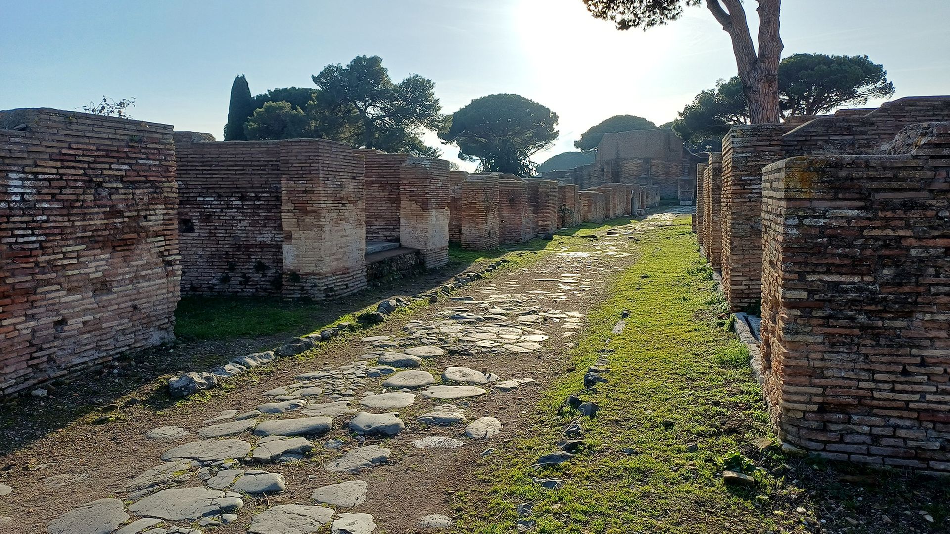
A road made of cobble stone steps goes between stone walls.

The ancient streets of Ostia, the seaport of Rome at the mouth of the Tiber River, are still visible today. (Image credit: Tom Brughmans)

"It follows the North African and Levantine coast past Antioch and near Ankara, crosses over to Europe at Constantinople, and moves through the Po Valley and Milan into France," study co-author Tom Brughmans, a professor of classical archaeology at Aarhus University in Denmark, told Live Science in an email.

The other well-connected cities had a bevy of reasons for their numerous roads. For instance, Corinth was better connected to the road network because the roads that ran through it linked the Greek Peloponnesian Peninsula to the rest of Greece, and Ancyra was better connected because it was a vital transportation hub for Anatolia.

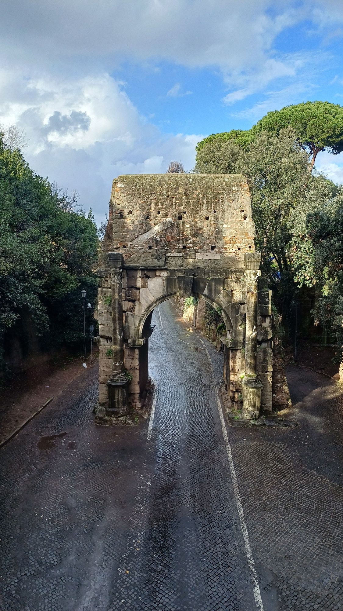
A stone archway is seen above a road.

The Arch of Drusus in Rome is near the beginning of the Via Appia, an ancient and famous Roman road that is still in use today. (Image credit: Tom Brughmans)

Rome's unique location is likely the biggest reason why it wasn’t as well connected to the road system as these other cities.

Brughmans noted that the "Italian Peninsula is an appendix to the empire's road network, and Rome is halfway down this appendix." And when "we consider all movement within the entire Italian Peninsula, we were shocked to discover that the most central road actually follows the opposite Adriatic coastline, bypassing Rome altogether," Brughmans added.

The study also found that when the shape of the land allowed it, Roman roads tended to be straight, but they were not as straight as modern-day roads.

Today, "modern road building avoids sharp turns and aims to build as straight roads as possible by strongly modifying the terrain to facilitate faster travel by car, which is made possible by modern surveying and construction methods," the team wrote in their paper.

Sea and river connections

Although the new research sheds light on road connections, it's important to remember that road travel wasn't the only means of transport in the Roman Empire. In fact, the researchers noted that Rome may have had a more significant position for sea and river transportation than it had for road transportation.

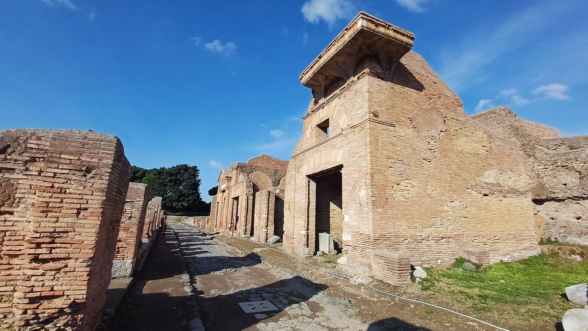
Ancient stone buildings sit next to a road.

Passersby can still walk on the city streets of the ancient port city Ostia. (Image credit: Tom Brughmans)

Although the study didn't look at waterways, Rome's central location in the empire meant that it would have been an important hub of water transport, the team wrote in the study.

"Rome's central location is not due to its roads, but its physical location in the centre of the Mediterranean, on the nexus of major shipping lanes," Brughmans explained.

The team said future studies should examine sea and river transport and integrate their findings with the team's Roman roads study. When considered together, road and waterway routes may help researchers better understand Roman transportation networks.

Pažout, A. et al. (2026). Network science reveals the structure and lasting impact of the Roman road system. Nature Communications, 17(9551). https://doi.org/10.1038/s41467-026-75453-3

From Augustus to Nero, see how much you know about ancient Rome's famous leaders with our Roman emperor quiz!

15,000-Year-Old Stone Tool Experiments Shed Light on Mysterious Ancient Technological Transition

15 September 2026 at 13:55

Stanford University scientists say experiments on ancient Chinese stone tools, including 15,000-year-old hand axes, have solved a longstanding mystery about the critical technological transition from rudimentary hand tools to more versatile ground-edged tools, suggesting these new technologies enabled uses beyond food harvesting.

The research team behind the new analysis said the discovery of ground-edged sickles and knives in Neolithic North China, likely used for fiber production and harvesting, combined with their replica-based experiments, highlights the growing technological capabilities of the transition between Paleolithic and Neolithic peoples.

“The combined experimental and archaeological evidence from the site of Peiligang indicates that the emergence of ground-edged tools marked a significant step in technological specialization from the Late Pleistocene to the Early Holocene,” the researchers write in a paper detailing the work.

Mysterious Technological Transition Hidden in 15,000-Year-Old Stone Tools

According to lead author Ran Chen and colleagues, archaeologists widely regard ground-edged cutting tools like the modern sickle as “technological hallmarks of early agriculture in North China.” However, they note, the functional foundations of this advanced toolmaking capability “remain insuf­ficiently tested.”

The research team also noted that most analyses of the transition from the Upper Paleolithic to the Early Neolithic (ca. 15,000–8,000 BP) in ancient China have viewed tools through “the lens of food production.”

“Within this framework, cutting tools, including early flakes and blades and later ground-edged sickles and knives, are often interpreted primarily as implements for harvesting cereals through cutting stems and leaves,” they explained.

The researchers said these earlier findings made them wonder whether this “food-focused perspective” could have led researchers to miss the broader range of plant resource exploitation possibilities in some of the 15,000-year-old stone tools previously discovered, prompting their replica-based experiments.

“The development of stone tool technology in North China provides a framework for reassessing this long-term relationship between plant use and technological change,” they explained.

Experiments Reveal Ground-Edged Tools Were Multifunctional Implements

To test their hypothesis, Chen and colleagues analyzed 140 stone artifacts previously collected from the Peiligang site in Henan Province, China. This included some 15,000-year-old Upper Paleolithic flaked stone tools and several more advanced Early Neolithic flaked and ground-edged stone tools.

Rather than test irreplaceable artifacts, the study authors created realistic experimental replicas.

15000-year-old stone tools mystery
A researcher demonstrates the use of an experimental sickle replica to harvest velvet leaf (Image Credit: Ran Chen).

Testing the effectiveness of the oldest, most rudimentary stone flake designs and the more technologically advanced ground-edged tools for harvesting seed-bearing grasses, the researchers found little measurable advantage between the two designs.

However, when the researchers compared the 15,000-year-old stone flake tools against ground-edged tools made thousands of years later, they found the more technologically advanced tools were “significantly more efficient at cutting thick-stemmed weeds and fiber-yielding plants.”

“Upper Paleolithic flaked tools were multifunctional implements used for processing diverse plant and animal materials, and Early Neolithic flakes continued to serve similarly flexible roles,” the study authors explain. “In contrast, Early Neolithic ground- edged tools show marked specialization in plant- related tasks.”

More Advanced Tools Emerged Through Broader Functional Demands

When discussing the experimental results, the team noted that their findings were supported by microfiber and starch residues found on some of the ancient tools, suggesting that “ground- edged sickles and knives were used not only for plant foods but also for harvesting and processing fibrous plants.”

“These findings indicate that ground- edged cutting tools emerged through broader functional demands, including fiber production, and potentially vegetation clearance, rather than cereal harvesting alone,” they explained.

Beyond the food-harvesting uses of ground-edged tools, Chen and colleagues said their identification of non-food plant labor like fiber production as an important driver of technological evolution and specialization “reframes the emergence of ground- edged tools as part of a broader technological and economic reorganization in early Holocene East Asia.”

“These findings identify nonfood plant work as an important contributor to the adoption of ground-edged cutting tools and show that tools conventionally linked to early agriculture were shaped by broader demands than food production alone,” they explained.

Finally, the study authors suggested that their analysis of 15,000-year-old Chinese stone tools could “invite renewed attention” to ancient fiber-based economies and nonfood plant use during forager–farmer transitions and in early farming societies beyond China.

The study “Plant fiber exploitation contributed to the emergence of ground-edged cutting tools in North China” was published in Proceedings of the National Academy of Sciences. 

Christopher Plain has spent the last six years as Associate News Editor and Head Science Reporter at The Debrief. Follow and connect with him on X, learn about his novels at plainfiction.com, or email him at christopher@thedebrief.org.

Nature’s First Kiln May Have Been a Wildfire, New Research Reveals

15 September 2026 at 13:50

Long before pottery became a common art form, the southern Levant underwent major environmental changes that stripped vegetation from hillsides and caused large amounts of clay-rich soil to accumulate in the valleys.

Now, a new study led by Amos Frumkin at the Hebrew University of Jerusalem suggests this process may have exposed Neolithic communities to the effects of intense fire on clay. Frumkin refers to this as the natural kiln hypothesis.

The study, published in Geomorphology, examined evidence from ancient sediments, cave deposits, and charcoal remains and identified two separate periods when wildfire and erosion impacted the area.

The Hills That Burned Twice

The two periods are separated by more than 100,000 years; the first of them was the last interglacial, lasting from about 129,000 to 116,000 years ago. The second was the early Holocene, which lasted from about 11,000 to 7,000 years ago, a period that corresponds with the establishment of farming communities in the region. The most intense burning occurred between 9,500 and 8,200 years ago.

Both periods left similar evidence. Small charcoal particles in ancient lake sediments indicate periods of increased burning. Chemical signatures in cave formations show the loss of vegetation and soil that followed. Frumkin notes that the scale and timing of the fires point toward climatic causes rather than increased human use of fire, although people in the region already used fire on a limited scale.

A Natural Kiln

Once the vegetation disappeared, the hillsides could no longer retain soil when it rained. The terra rossa clay, therefore, washed down the slopes and collected in low-lying areas like the Jordan and Dead Sea valleys, building up in thick layers. Since this redeposited clay was very fertile, Neolithic settlements tended to cluster in these areas.

Pottery appeared in the region during the same time period. Earlier petrographic studies show that local redeposited terra rossa clay provided the material for Yarmukian pottery from the Jordan Valley, the same material that erosion deposited in Frumkin’s study.

“A wildfire is normally seen only as a catastrophe, but environmental disruption can also expose people to new materials and new possibilities,” said Frumkin. “Neolithic communities in the Jordan Valley may have watched fire transform the clay beneath and around their settlements and realized that this process could be reproduced deliberately. If so, one of humanity’s most important technologies may have emerged partly from people learning to imitate what they had already seen nature do.”

The 120,000-Year Comparison

This earlier period can serve as a comparison for this hypothesis. Vegetation also declined, and clay deposited heavily during the last interglacial period; however, pottery did not appear after that event. Frumkin sees this as an example of a natural limitation because the required materials were available 120,000 years earlier, but there were no settled, agricultural societies to identify and replicate the process.

The comparison suggests that environmental conditions alone were not enough to produce pottery. The innovation may have emerged when these conditions intersected with a society capable of recognizing the opportunity and reproducing what it observed.

Frumkin stresses that the hypothesis is still speculative. Although the fires, the clay deposits, and the earliest pottery all come from roughly the same period, current dating techniques cannot establish the exact order of events. Further excavations might search for fire-baked clay beneath the oldest pottery layers and test whether wildfires in the Jordan Valley reached the temperatures needed to harden clay. Finding any pottery that clearly predates the major fire episode would challenge this hypothesis.

Austin Burgess is a writer and researcher with a background in sales, marketing, and data analytics. He holds an MBA, a Bachelor of Science in Business Administration, and a data analytics certification. His work focuses on breaking scientific developments, with an emphasis on emerging biology, cognitive neuroscience, and archaeological discoveries.

An altar of fire and a 2,300-year-old chest found in Uzbekistan reopen the mystery of how the ancestors of the Zoroastrians buried their dead

15 September 2026 at 11:56
The site is provisionally dated to a six-century stretch, from the 3rd century BC to the 3rd century AD, offering a window into funerary rites practiced by a population that neither buried nor cremated its dead — long before that same principle produced the famous Towers of Silence. The find comes from Odirmon, a site […]

A Rare Etruscan Cube-Shaped Tomb from the Era of Rome’s Last Kings, with a Corinthian Krater Filled with Burned Bones, Discovered in Pontecagnano

15 September 2026 at 10:29
Anyone planning to build in Pontecagnano Faiano, near Salerno, has learned to expect a tomb underneath. That happened again this year, and this time the find was unusual enough that archaeologists had only seen its like twice before in more than sixty years of excavation. Preventive digging ahead of a private housing development uncovered a […]

Indigenous Australian population was much larger than previously thought and decimated after First Fleet's arrival

15 September 2026 at 10:00
Australia had a much larger Indigenous population before the arrival of Europeans than previously thought, according to new research. The research also demonstrates much larger population losses resulting from colonization than previously believed, with an estimated 93% of the pre-European population lost in less than 80 years following the 1788 arrival of the First Fleet.

Prehistoric builders transported Devil's Arrows 11 miles

14 September 2026 at 18:10

Stonehenge is the most famous example of megalithic architecture across Britain and Ireland, but there are plenty of others, including Calanais, Newgrange, and Avebury, as well as the Devil's Arrows. The latter is Britain's tallest standing stone alignment, yet little is known about the provenance of its stones. Scientists have confirmed that the stones came from a site 18 kilometers (11 miles) away, transported by humans rather than glacial movement, according to a paper published in the Proceedings of the Royal Society A: Mathematical, Physical and Engineering Sciences.

"Sites in southern England and Scotland receive considerable attention but monuments like the Devil's Arrows have remained comparatively understudied despite their significance," said co-author Jim Leary of the University of York. "We have now proved that Neolithic communities moved several 25-ton stones across Yorkshire, transforming a familiar site into an epic quest to create a sacred landscape."

Stonehenge has been the focus of recent chemical analyses identifying where all the stones that make up the structure came from, revealing that many originated in quarries a significant distance away. For instance, a 2019 study concluded that the 42 bluestones that make up the inner ring came all the way from western Wales. The outer layer of sarsen stones hails from much closer to home: Marlborough Downs, an area of round, grassy hills 25 to 30 km (17 miles) north of Stonehenge, which has the largest concentration of sarsen in the UK.

Read full article

Comments

© University of York

Archaeologists Just Dug Beneath a Legendary Slavic Fortress in Germany — and Found a Settlement 5,000 Years Older

14 September 2026 at 16:28
In the German state of Brandenburg, barely a hundred meters (about 330 feet) from the border with Saxony-Anhalt, the Havel River curls around a low rise of land that locals call the Pilatsch. For generations, a local legend held that a knight named Pilatus lived there, ambushing boats on the river and locking captured boatmen […]

DNA From Ancient Grape Seeds Shows Spain’s Wine Came From the Phoenicians, Not the Romans

14 September 2026 at 11:20
One grape variety still grown in Spanish vineyards, hebén, has never gone out of cultivation for at least the last 1,100 years, according to the new study. That takes its lineage back to roughly the year 929, around when the Caliphate of Córdoba was proclaimed in southern Spain. Eleven centuries of unbroken agriculture, and the […]

❌