 Login

A Perfectly Timed Perseid Meteor Shower
5 August 2026 at 16:02
With a new Moon in play, skywatchers anticipate a fine Perseid performance this year.
The post A Perfectly Timed Perseid Meteor Shower appeared first on Sky & Telescope.

With a new Moon in play, skywatchers anticipate a fine Perseid performance this year.
The post A Perfectly Timed Perseid Meteor Shower appeared first on Sky & Telescope.
3 min read

Written by Abigail Fraeman, Deputy Project Scientist, Jet Propulsion Laboratory, California Institute of Technology
Earth planning date: Friday, July 24, 2026
Curiosity spent the week continuing to climb her way up through the layers of Mount Sharp, exploring the sedimentary rock strip chart of Martian history. The rover has reached a layer where the science team had spotted a possible “erosional supersurface” by analyzing orbital data alongside images of the layers in the buttes above us. “Erosional supersurface” is a geologic term that describes places where layers of sediment have been stripped away by wind or water at a regional scale before newer layers are deposited atop them. These surfaces are common in wind-blown sand (aeolian) deposits, and they mark a break in the rock record. After eyeing this unusual section of Mount Sharp for the last few months, it’s exciting to finally be so close to this feature. Curiosity’s science instruments will give us the geologist’s-eye view of this region that we need to really understand this feature, including its composition and centimeter-scale geometry.
Our two plans this week focused on imaging the possible supersurface from a few different locations. This past weekend we backed away from the feature to get a good rover’s-eye view of the feature, which set us up nicely on Monday to collect two massive Mastcam mosaics across the entire layer. ChemCam provided additional support by collecting some long-distance RMI images of the most interesting areas of the supersurface. We also took the time to measure the composition of rocks at the bottom of this surface with a MAHLI and APXS target named “Monte Darwin” and ChemCam LIBS targets named “Patacamaya,” “Tarucachi,” and “Mojoncasa.”
Monday’s drive took us closer to the supersurface, while taking some MAHLI and Mastcam images of our wheels along the way, and the drive we planned today will bring us right up to the base of the layer. The science team was able to use Monday’s image to pick the most scientifically interesting spot to cross this surface, while also juggling constraints made by the reality of where we can drive our rather large rover — there’s some pretty sandy and steeply sloping terrain around here, so we also found a spot that looks like it’ll be one of the easier areas to traverse. Hopefully next week we’ll go up and over the supersurface — stay tuned.

Mars is the fourth planet from the Sun, and the seventh largest. It’s the only planet we know of inhabited…
Explore this collection of Mars images, videos, resources, PDFs, and toolkits. Discover valuable content designed to inform, educate, and inspire,…
Each robotic explorer sent to the Red Planet has its own unique capabilities driven by science. Many attributes of a…
The key to understanding the past, present or future potential for life on Mars can be found in NASA’s four…
The only total solar eclipse of the year coincides with the Perseid meteor shower. Here's what you need to know to watch the eclipse.
The post Rare Total Solar Eclipse-Perseid Meteor Shower Double-Header August 12th appeared first on Sky & Telescope.
Usuários do Threads em todo o mundo já podem enviar mensagens para a Meta AI por meio da área de mensagens diretas (direct messages, ou DMs) da rede social, segundo informações do Engadget.
Antes disso, já era possível interagir com o chatbot da empresa comandada por Mark Zuckerberg em certos mercados por meio de menções em posts, mas essa nova opção permite iniciar conversas mais privadas com a ferramenta.
Segundo a Meta, é possível compartilhar posts do Threads, imagens, links e vídeos com a Meta AI, bem como manter conversas duradouras e explorar tópicos de interesse do usuário. “A experiência de mensagens diretas (DMs) oferece às pessoas maior flexibilidade sobre como e onde interagem com a Meta AI”, afirmou a companhia em um comunicado.

O próprio sistema de DMs é uma adição relativamente recente ao Threads, que só foi ganhar esse recurso no ano passado. Com essa atualização, a rede social fica em paridade com as outras plataformas da Meta (Facebook, Instagram e WhatsApp), que já permitem o envio de mensagens privadas para a Meta AI há algum tempo.
A empresa disse ainda que pretende continuar testando a interação com a Meta AI em feeds públicos em mercados selecionados e que considera aumentar sua disponibilidade. Nos lugares nos quais essa função já pode ser acessada, basta incluir @meta.ai na sua postagem com o prompt. Para diminuir a frequência com que ela aparece no seu feed, selecione a opção “Não tenho interesse”.
3 min read
Written by Lucy Thompson, Senior Research Scientist, University of New Brunswick, Canada
Earth planning date: Friday, July 27, 2026
As an APXS uplink lead and strategic planner, I have the privilege of working with the rover engineers most days that I am on operations. The APXS instrument measures the chemistry of rocks, unconsolidated materials and the atmosphere, and is situated on the end of Curiosity’s robotic arm. This means that any target of interest that we wish to analyze has to be safe to deploy the arm, APXS, and MAHLI (the closeup imager) to. We therefore rely on the rover engineers for their assessment and to sequence the arm moves to place us safely on the targets. Recently, our workspaces have been dusty with varied relief, but the rover engineers have successfully found areas that they have been able to brush and deploy APXS and MAHLI. This week was no exception, despite some of our workspaces appearing less than ideal upon initial observation. The team managed to find rock targets of interest (x5), which the rover engineers were able to safely place the arm on and brush so that we could analyze them with APXS and MAHLI. This ensures that we acquire high-quality compositional data and images as we continue our ascent of Mount Sharp, through rock layers of varying tone and texture, tracking potential changes in chemistry, and the depositional and alteration environment.
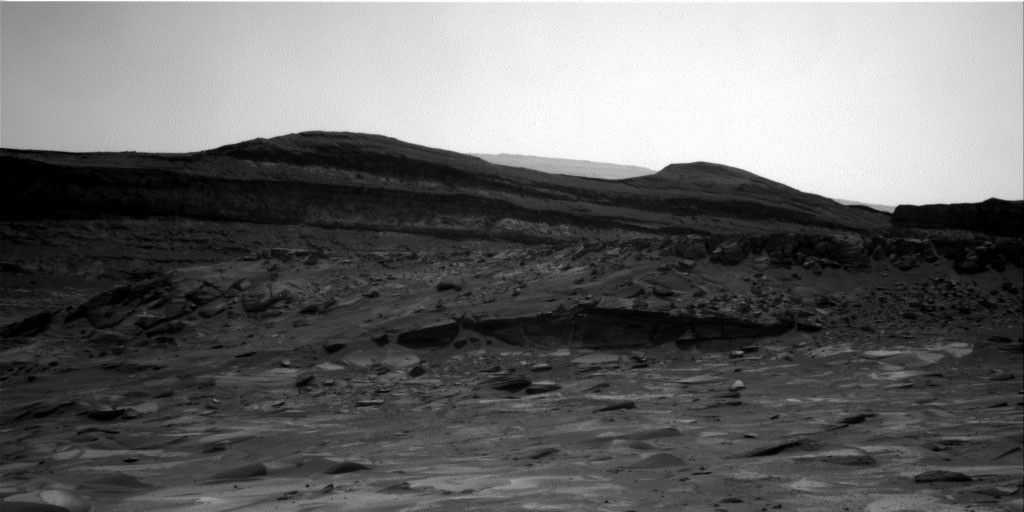
The rover engineers are also responsible for safely driving Curiosity to the areas of interest identified by the science team. They must assess the terrain for potential hazards such as large resistant blocks that could damage the rover wheels, sand/soil patches where we could get stuck, and high slopes that the rover could slip on. Despite unexpected damage to the wheels early in the mission and getting a little bogged down in some soil/sand just as we started to climb Mount Sharp, the engineers have successfully navigated us safely along more than 23 miles (37 kilometers) of drive distance and more than 4,400 feet (about 1.35 kilometers) of elevation gain. We recently requested to drive to specific locations in order to image what the team thinks could be an erosional surface within the Mg-sulfate/carbonate-bearing unit (see the image accompanying this post). Of course, the engineers were able to accommodate our desires, with the first stop crossed off in Monday’s plan, and the drive that is being planned this weekend taking us toward the next stop.
The rover engineers also ensure that our drilling activities execute safely and successfully, and are responsible for sequencing the arm motion required to deliver the drilled samples to our internal CheMin and SAM instruments. This required completely reconfiguring how we drill after a motor failed back in 2016, with extensive behind-the-scenes work at JPL for nearly a year and a half before we resumed. Curiosity has since drilled more than 20 rock targets.
So, thanks to the rover engineers and all the engineers and scientists on Curiosity’s team, we have had another full week of activities at Gale crater. We continue to track the chemistry, textures, tone and sedimentary structures of the sulfate/carbonate unit as we climb Mount Sharp and get ever closer to the Yardang unit with APXS, ChemCam, MAHLI and Mastcam. Curiosity continues to also monitor the local environment within Gale and the atmosphere in general.
Mars is the fourth planet from the Sun, and the seventh largest. It’s the only planet we know of inhabited…
Explore this collection of Mars images, videos, resources, PDFs, and toolkits. Discover valuable content designed to inform, educate, and inspire,…
Each robotic explorer sent to the Red Planet has its own unique capabilities driven by science. Many attributes of a…
The key to understanding the past, present or future potential for life on Mars can be found in NASA’s four…
This periodic visitor is now bright enough to see in binoculars from a dark sky. We also report on a bright supernova in Ursa Major.
The post Comet 10P/Tempel Brightens, Sets Sail South appeared first on Sky & Telescope.
China’s Tianwen 2 mission returns its close view of Earth's tiny "quasi-moon" Kamoʻoalewa.
The post Tianwen 2 Arrives at Quasi-Moon Kamoʻoalewa, Returns Images appeared first on Sky & Telescope.
Here's an observing guide to both familiar and lesser-known deep-sky objects that inhabit our galaxy's equatorial zone.
The post Steamy Nights at the Galactic Equator appeared first on Sky & Telescope.
Japan’s Hayabusa 2 mission has revealed another "snowman" asteroid — a pair of asteroids attached with a narrow neck. The contact binary could help shed light on planet formation.
The post Hayabusa 2 Completes Flyby Past Asteroid Torifune appeared first on Sky & Telescope.
4 min read

By Susanne P. Schwenzer, Professor of Planetary Mineralogy at The Open University, UK
Earth planning date: Thursday, June 18, 2026
In the area Curiosity is currently exploring, the science team has mapped several areas with different-looking surface texture on the orbital images. If you wanted to have a look yourself at what there is to see, check the “Where is Curiosity?” map. You’ll discover different shades of orange and beige as well as more rough and more smooth-looking textures. This is what the geomorphologists in our team use to map the areas for exploration by the rover. Of course, we then supplement this all with ground-based images, including bespoke “drive direction imaging,” which is taken after each drive by the Mast Camera. Drive planning is done using a combination of all this information. So there shouldn’t be any surprises, right?
On Monday the team planned three sols in preparation for a Thursday planning to account for the U.S. federal holiday weekend. The workspace turned out to be a little spiky, so we could not find an area we could DRT. APXS still found one good bedrock target, “Rio Baker,” which also had MAHLI documentation. In addition, ChemCam investigated “Rica Aventura,” a textured bedrock, and “Tabebuia,” a darker-looking individual block, using its LIBS and conducted a passive spectral observation on a second dark float block called “Lago Ranco.” Of course, the team also wanted to look into the distance with ChemCam remote imaging, extending our investigation of the Cordillera base outcrop.
Imaging is always high on the list. In Monday’s plan Mastcam is looking into the modern dunes with the “Tacaza” mosaic, and with more mosaics looking forward to the future parking areas, some of which looked really smooth from that vantage point. We also continue our environmental and atmospheric observations looking for dust devils, the opacity of the atmosphere, and monitoring pressure and temperature. After all this, the rover drove about 35 meters (about 115 feet) to an area that looked really smooth in all images we had available at that point. So we were hoping for a good spot to deploy the DRT, but didn’t think we could be in for a surprise.
The drive ended exactly as planned, spot-on in the middle of that — from a distance — smooth-looking area. But when we opened the post-drive images on Thursday morning, we were all reacting with a lot of surprise. From up close, the parking spot looks anything but smooth. You can see the surprise in the title image of this blog. There are polygons, veins, lamination, and probably more, once we inspect the higher-resolution images taken today. “Higher-resolution” is the key for why we were in for such a surprise! The features are quite small, a few centimeters across, and therefore we could not see them in the orbital images or from a distance in our navigation and mast camera images. The camera resolution from a distance just isn’t enough to see them. But up close, the terrain revealed all its beauty! And I am sure there will be more in the even higher resolution of today’s MAHLI and ChemCam RMI imager images!
So, what did we plan after we caught our breath on Thursday? First, you guessed it, images, images, and more images. Mastcam takes a full panorama with its “left eye” and adds a range of closer-up mosaics with its higher-resolution “right eye.” In addition there is a ChemCam Remote Micro Imager image to document structures further afield at high resolution. ChemCam is investigating three targets using LIBS: “Rio Chimore” is a lighter-toned band; you can see some of those in the cover image of this blog, too. The other two LIBS targets are “Rio de Lava,” a vein target, and “Rio de Salta,” one of the polygons. APXS is also looking at the bedrock and the ridges, at the targets “Pampa Grande” and “Iquique Ridge.” MAHLI is having the above-mentioned close “hand lens” look. Let’s see what we will discover when we get those images.
Finally, Curiosity drove up the hill along very smooth-looking terrain that is just littered with tiny polygons. Let’s see if we are in for another surprise reverberating around all our offices — and across two continents, as I had the good fortune to be among the first ones, here in England (Or maybe it was our French ChemCam colleagues, who are in a time zone one hour ahead of me?). Whichever it is, this terrain has a lot to say about the geologic history of Mars!
Mars is the fourth planet from the Sun, and the seventh largest. It’s the only planet we know of inhabited…
Explore this collection of Mars images, videos, resources, PDFs, and toolkits. Discover valuable content designed to inform, educate, and inspire,…
Each robotic explorer sent to the Red Planet has its own unique capabilities driven by science. Many attributes of a…
The key to understanding the past, present or future potential for life on Mars can be found in NASA’s four…
4 min read
By Susanne P. Schwenzer, Professor of Planetary Mineralogy at The Open University, UK
Earth planning date: Thursday, June 18, 2026
In the area Curiosity is currently exploring, the science team has mapped several areas with different-looking surface texture on the orbital images. If you wanted to have a look yourself at what there is to see, check the “Where is Curiosity?” map. You’ll discover different shades of orange and beige as well as more rough and more smooth-looking textures. This is what the geomorphologists in our team use to map the areas for exploration by the rover. Of course, we then supplement this all with ground-based images, including bespoke “drive direction imaging,” which is taken after each drive by the Mast Camera. Drive planning is done using a combination of all this information. So there shouldn’t be any surprises, right?
On Monday the team planned three sols in preparation for a Thursday planning to account for the U.S. federal holiday weekend. The workspace turned out to be a little spiky, so we could not find an area we could DRT. APXS still found one good bedrock target, “Rio Baker,” which also had MAHLI documentation. In addition, ChemCam investigated “Rica Aventura,” a textured bedrock, and “Tabebuia,” a darker-looking individual block, using its LIBS and conducted a passive spectral observation on a second dark float block called “Lago Ranco.” Of course, the team also wanted to look into the distance with ChemCam remote imaging, extending our investigation of the Cordillera base outcrop.
Imaging is always high on the list. In Monday’s plan Mastcam is looking into the modern dunes with the “Tacaza” mosaic, and with more mosaics looking forward to the future parking areas, some of which looked really smooth from that vantage point. We also continue our environmental and atmospheric observations looking for dust devils, the opacity of the atmosphere, and monitoring pressure and temperature. After all this, the rover drove about 35 meters (about 115 feet) to an area that looked really smooth in all images we had available at that point. So we were hoping for a good spot to deploy the DRT, but didn’t think we could be in for a surprise.
The drive ended exactly as planned, spot-on in the middle of that — from a distance — smooth-looking area. But when we opened the post-drive images on Thursday morning, we were all reacting with a lot of surprise. From up close, the parking spot looks anything but smooth. You can see the surprise in the title image of this blog. There are polygons, veins, lamination, and probably more, once we inspect the higher-resolution images taken today. “Higher-resolution” is the key for why we were in for such a surprise! The features are quite small, a few centimeters across, and therefore we could not see them in the orbital images or from a distance in our navigation and mast camera images. The camera resolution from a distance just isn’t enough to see them. But up close, the terrain revealed all its beauty! And I am sure there will be more in the even higher resolution of today’s MAHLI and ChemCam RMI imager images!
So, what did we plan after we caught our breath on Thursday? First, you guessed it, images, images, and more images. Mastcam takes a full panorama with its “left eye” and adds a range of closer-up mosaics with its higher-resolution “right eye.” In addition there is a ChemCam Remote Micro Imager image to document structures further afield at high resolution. ChemCam is investigating three targets using LIBS: “Rio Chimore” is a lighter-toned band; you can see some of those in the cover image of this blog, too. The other two LIBS targets are “Rio de Lava,” a vein target, and “Rio de Salta,” one of the polygons. APXS is also looking at the bedrock and the ridges, at the targets “Pampa Grande” and “Iquique Ridge.” MAHLI is having the above-mentioned close “hand lens” look. Let’s see what we will discover when we get those images.
Finally, Curiosity drove up the hill along very smooth-looking terrain that is just littered with tiny polygons. Let’s see if we are in for another surprise reverberating around all our offices — and across two continents, as I had the good fortune to be among the first ones, here in England (Or maybe it was our French ChemCam colleagues, who are in a time zone one hour ahead of me?). Whichever it is, this terrain has a lot to say about the geologic history of Mars!
Mars is the fourth planet from the Sun, and the seventh largest. It’s the only planet we know of inhabited…
Explore this collection of Mars images, videos, resources, PDFs, and toolkits. Discover valuable content designed to inform, educate, and inspire,…
Each robotic explorer sent to the Red Planet has its own unique capabilities driven by science. Many attributes of a…
The key to understanding the past, present or future potential for life on Mars can be found in NASA’s four…
The post Curiosity Blog, Sols 4927–4933: Let’s Drive to That Smooth Area appeared first on NASA Science.
3 min read
Written by William Farrand, Senior Research Scientist, Space Science Institute
Earth planning date: Friday, June 12, 2026
Rather than going from stage to stage at a music festival to hear different bands playing different varieties of music, Curiosity has been ascending up Mount Sharp through physical bands of exposed rocks with textural and tonal differences.
Planning for sols 4920 and 4921 were done with the rover in the middle of a unit with a rougher texture and dark-toned bedrock. With the rougher-textured bedrock, brushing wasn’t possible, but APXS chemistry and MAHLI micro-imaging were planned on “as is” bedrock targets “Salto La Cascada” and “Puerto de Rosas.” ChemCam was targeted to perform LIBS spectroscopy on a bedrock target “Kishuara” and a small, layered float rock “La Rosita.” ChemCam’s Remote Micro-Imager (RMI) collected views of the “Mishe Mokwa” butte and another looking at dunes with tonal differences. Mastcam mosaics were collected on the “Valle Grande” channel, “Kimsa Chata” butte, nearby troughs, and the aircraft carrier shaped rock “El Matir.”
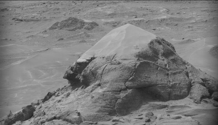
Another drive brought Curiosity closer to the upper border of the dark-toned band. Again, brushing of the rocks was not possible, but APXS and MAHLI were collected on dark-toned bedrock targets “Santa Gracia” and “Laguna San Rafael” with ChemCam LIBS also targeting the bedrock. Mastcam mosaics were collected of a layered rock and nearby troughs and a mosaic of the nearby smaller butte, “Miraflores” which displays an interesting layered structure with ragged dark-toned rocks on one side and a stack of dust piled on top (see accompanying image). Other activities included a long-distance RMI mosaic of a bright unit on “Mishe Mokwa”, and Navcam dust-devil surveys in both sols.
Communicating between Earth and Mars has come to seem routine, but at times can still be a challenging endeavor and this was demonstrated to the team on Friday when we did not get a timely downlink of data for the drive planned for Sol 4923. Without these images another drive, in situ examinations, or targeted remote sensing could not be planned. However, there are always interesting things to be done on Mars and the three-sol plan (4924 to 4926) included a 360-degree Mastcam mosaic, the automatic AEGIS targeting of LIBS measurements on each sol, a Navcam dust-devil survey, APXS atmospheric measurements, as well as several other environmental activities.
On Monday, the delayed downlink will be used to plan the first investigation of the next band of surface materials, this one being smooth-textured and light-toned, as well as another drive to continue the surveying of the bands.
Mars is the fourth planet from the Sun, and the seventh largest. It’s the only planet we know of inhabited…
Explore this collection of Mars images, videos, resources, PDFs, and toolkits. Discover valuable content designed to inform, educate, and inspire,…
Each robotic explorer sent to the Red Planet has its own unique capabilities driven by science. Many attributes of a…
The key to understanding the past, present or future potential for life on Mars can be found in NASA’s four…
The post Curiosity Blog, Sols 4920-4926: Surveying the Bands appeared first on NASA Science.
3 min read
Written by William Farrand, Senior Research Scientist, Space Science Institute
Earth planning date: Friday, June 12, 2026
Rather than going from stage to stage at a music festival to hear different bands playing different varieties of music, Curiosity has been ascending up Mount Sharp through physical bands of exposed rocks with textural and tonal differences.
Planning for sols 4920 and 4921 were done with the rover in the middle of a unit with a rougher texture and dark-toned bedrock. With the rougher-textured bedrock, brushing wasn’t possible, but APXS chemistry and MAHLI micro-imaging were planned on “as is” bedrock targets “Salto La Cascada” and “Puerto de Rosas.” ChemCam was targeted to perform LIBS spectroscopy on a bedrock target “Kishuara” and a small, layered float rock “La Rosita.” ChemCam’s Remote Micro-Imager (RMI) collected views of the “Mishe Mokwa” butte and another looking at dunes with tonal differences. Mastcam mosaics were collected on the “Valle Grande” channel, “Kimsa Chata” butte, nearby troughs, and the aircraft carrier shaped rock “El Matir.”
Another drive brought Curiosity closer to the upper border of the dark-toned band. Again, brushing of the rocks was not possible, but APXS and MAHLI were collected on dark-toned bedrock targets “Santa Gracia” and “Laguna San Rafael” with ChemCam LIBS also targeting the bedrock. Mastcam mosaics were collected of a layered rock and nearby troughs and a mosaic of the nearby smaller butte, “Miraflores” which displays an interesting layered structure with ragged dark-toned rocks on one side and a stack of dust piled on top (see accompanying image). Other activities included a long-distance RMI mosaic of a bright unit on “Mishe Mokwa”, and Navcam dust-devil surveys in both sols.
Communicating between Earth and Mars has come to seem routine, but at times can still be a challenging endeavor and this was demonstrated to the team on Friday when we did not get a timely downlink of data for the drive planned for Sol 4923. Without these images another drive, in situ examinations, or targeted remote sensing could not be planned. However, there are always interesting things to be done on Mars and the three-sol plan (4924 to 4926) included a 360-degree Mastcam mosaic, the automatic AEGIS targeting of LIBS measurements on each sol, a Navcam dust-devil survey, APXS atmospheric measurements, as well as several other environmental activities.
On Monday, the delayed downlink will be used to plan the first investigation of the next band of surface materials, this one being smooth-textured and light-toned, as well as another drive to continue the surveying of the bands.
Mars is the fourth planet from the Sun, and the seventh largest. It’s the only planet we know of inhabited…
Explore this collection of Mars images, videos, resources, PDFs, and toolkits. Discover valuable content designed to inform, educate, and inspire,…
Each robotic explorer sent to the Red Planet has its own unique capabilities driven by science. Many attributes of a…
The key to understanding the past, present or future potential for life on Mars can be found in NASA’s four…
On June 17th, much of North America can watch the Moon occult Venus in the daytime sky. All you need are binoculars.
The post See Venus Disappear in Broad Daylight on June 17th appeared first on Sky & Telescope.

NASA’s X-59 experimental aircraft reached a major milestone Friday, June 12, flying Mach 1.4 (about 924 mph) and an altitude of 55,000 feet, the conditions required for the aircraft to make future flights critical to its mission.
The X-59 still has months of performance testing ahead, but after those are complete, NASA’s Quesst mission will fly the aircraft over several U.S. communities to collect data on public perception of the quiet sonic thump it will make at supersonic speeds. Those community overflights will include flights at Mach 1.4 and 55,000 feet.
The milestone comes just days after the X-59’s first supersonic flight. That flight showed the aircraft performed as expected at Mach 1.1, but Friday’s mission conditions flight was an even more critical step for NASA.
The aircraft’s team has steadily expanded the aircraft’s flight envelope by evaluating its performance at a variety of speeds and altitudes, and having its pilots take on a battery of maneuvers.

The X-59 was designed to fly supersonic without causing a loud sonic boom. However, for these early supersonic flights it has been accompanied by a NASA F-15 research aircraft, a traditional supersonic jet that causes booms obscuring any noise the X-59 makes. During upcoming flights, a shock-sensing probe mounted to the F-15 will gather measurements of the X-59’s shock wave signature, an early measure of its supersonic performance.
After the team conducts more tests at a variety of altitudes and conditions to complete envelope expansion, the X-59 will enter the acoustic validation phase of Quesst. During this phase, researchers will thoroughly measure the aircraft’s supersonic acoustic signature — the quiet thump it’s designed to make — to confirm it is performing as intended.
Each flight brings NASA one step closer to flying the X-59 over communities and gathering feedback that could help shape the future of commercial supersonic flight over land.

The post NASA’s X-59 Reaches Speed, Altitude for Future Quiet Supersonic Flights appeared first on NASA Science.
3 min read

Written by Catherine O’Connell-Cooper, APXS Strategic Planner and Payload Uplink/Downlink Lead, University of New Brunswick, Canada
Earth planning day: Friday, June 5th, 2026
In a very broad sense, Curiosity has two modes of doing science – one centred around a defined science campaign (such as the recent boxwork campaign) and the other as we move between campaigns. During a science campaign, with a very defined start and end location, every image and every workspace is carefully choregraphed to make sure we hit all of our science goals for the campaign. This is a lot of pressure!
But in between campaigns, the emphasis moves to driving towards the next major campaign. Our next major stop is the yardang unit, a series of intriguing wind sculpted, pale coloured hills which you can just see in the distance in the cover image for this blog. The rover planners (RPs) sometimes make our drives as long as they can and we drive as far as we can go, other times we stop a little short to look at interesting looking workspaces as we go. As part of the APXS team, I loved being part of the boxwork campaign and getting all the information we needed there … but as a geologist, there is something very special about this kind of exploring, the sense of being a planetary explorer, ambling along to see what the rocks will show us.
So we continue southwards, trundling over laminated bedrock which varies from predominantly pale coloured laminated bedrock to bands with abundant thin flaky, darker coloured, layers and patches. Some of the rocks stick out at strange angles, which make planning drives more challenging. This past week there has been abundant dark layers interbedded with the more dominant pale coloured rock, both in place and in fragments around the workspace. APXS and MAHLI characterized some of this darker material, for example at “Rio Bio Bio” and “Placilla de Caracoles” and some of the paler material at the brushed targets “La Primavera” and “Los Quemados.” ChemCam also analyzed both types of rocks along the way.
We are busily acquiring Mastcam and ChemCam LD-RMI (“Long Distance Remote Micro Imager”) images of everything even remotely interesting – and there are lots and lots of cool features around here. The wide open landscape here allows us to image features from several different angles and distances, such as “Mira Flores,” a small erosional outlier seen from a distance in this image and closer up here. Another great example is the “Kimsa Chata” trough which shows some amazing sedimentary structures, which may help us to determine if this was a desert or a lake or maybe something in between, such as a desert with some water moving through.
The Environmental Theme Group continues to populate each plan with environmental monitoring activities. Activities varied from dust devil monitoring in Gale crater to looking at levels of dust in the skies overhead. The weekend drive is planned to take us further into that drive distance shown in the cover image, to an area where the contrast between dark and light bedrock is more pronounced, and just beyond that, to an area which looks very smooth, with no jutting out blocks. From where we sit today, its impossible to say what it is but that is the fun of exploring – who knows what we will find? Stay tuned to find out over the coming weeks.
Mars is the fourth planet from the Sun, and the seventh largest. It’s the only planet we know of inhabited…
Explore this collection of Mars images, videos, resources, PDFs, and toolkits. Discover valuable content designed to inform, educate, and inspire,…
Each robotic explorer sent to the Red Planet has its own unique capabilities driven by science. Many attributes of a…
The key to understanding the past, present or future potential for life on Mars can be found in NASA’s four…
3 min read
Written by Catherine O’Connell-Cooper, APXS Strategic Planner and Payload Uplink/Downlink Lead, University of New Brunswick, Canada
Earth planning day: Friday, June 5th, 2026
In a very broad sense, Curiosity has two modes of doing science – one centred around a defined science campaign (such as the recent boxwork campaign) and the other as we move between campaigns. During a science campaign, with a very defined start and end location, every image and every workspace is carefully choregraphed to make sure we hit all of our science goals for the campaign. This is a lot of pressure!
But in between campaigns, the emphasis moves to driving towards the next major campaign. Our next major stop is the yardang unit, a series of intriguing wind sculpted, pale coloured hills which you can just see in the distance in the cover image for this blog. The rover planners (RPs) sometimes make our drives as long as they can and we drive as far as we can go, other times we stop a little short to look at interesting looking workspaces as we go. As part of the APXS team, I loved being part of the boxwork campaign and getting all the information we needed there … but as a geologist, there is something very special about this kind of exploring, the sense of being a planetary explorer, ambling along to see what the rocks will show us.
So we continue southwards, trundling over laminated bedrock which varies from predominantly pale coloured laminated bedrock to bands with abundant thin flaky, darker coloured, layers and patches. Some of the rocks stick out at strange angles, which make planning drives more challenging. This past week there has been abundant dark layers interbedded with the more dominant pale coloured rock, both in place and in fragments around the workspace. APXS and MAHLI characterized some of this darker material, for example at “Rio Bio Bio” and “Placilla de Caracoles” and some of the paler material at the brushed targets “La Primavera” and “Los Quemados.” ChemCam also analyzed both types of rocks along the way.
We are busily acquiring Mastcam and ChemCam LD-RMI (“Long Distance Remote Micro Imager”) images of everything even remotely interesting – and there are lots and lots of cool features around here. The wide open landscape here allows us to image features from several different angles and distances, such as “Mira Flores,” a small erosional outlier seen from a distance in this image and closer up here. Another great example is the “Kimsa Chata” trough which shows some amazing sedimentary structures, which may help us to determine if this was a desert or a lake or maybe something in between, such as a desert with some water moving through.
The Environmental Theme Group continues to populate each plan with environmental monitoring activities. Activities varied from dust devil monitoring in Gale crater to looking at levels of dust in the skies overhead. The weekend drive is planned to take us further into that drive distance shown in the cover image, to an area where the contrast between dark and light bedrock is more pronounced, and just beyond that, to an area which looks very smooth, with no jutting out blocks. From where we sit today, its impossible to say what it is but that is the fun of exploring – who knows what we will find? Stay tuned to find out over the coming weeks.
Mars is the fourth planet from the Sun, and the seventh largest. It’s the only planet we know of inhabited…
Explore this collection of Mars images, videos, resources, PDFs, and toolkits. Discover valuable content designed to inform, educate, and inspire,…
Each robotic explorer sent to the Red Planet has its own unique capabilities driven by science. Many attributes of a…
The key to understanding the past, present or future potential for life on Mars can be found in NASA’s four…
The post Curiosity Blog: Sols 4913-4919: Planetary explorers, freewheeling to the Yardang unit! appeared first on NASA Science.
