Robots slithered like snakes into the rubble of collapsed buildings to search for trapped survivors in the aftermath of Venezuela’s double earthquake disaster.
The so-called snake robots represented a unique technological aid for international search and rescue efforts following two earthquakes that struck Venezuela on June 24, killing more than 5,000 people and leaving behind 16,740 injured. Rescuers from around the world used trained dogs, seismic and acoustic listening devices, video cameras on sticks, or thermal imaging cameras to search for signs of survivors—but the snakebots equipped with a video camera could squeeze through tight spaces to search deep within fallen building debris.
“The reason why snake robots are useful is they can get into tightly packed volumes that machinery and people otherwise cannot, and that's important in search and rescue because we were able to extend the visual reach of the rescue workers in a safe way,” Howie Choset, head of the Biorobotics Lab at Carnegie Mellon University in Pittsburgh, told Ars. “In a sense, you're doing minimally invasive surgery on a structure with a snake robot.”
The two major earthquakes that struck Venezuela just 39 seconds apart on June 24 had slightly different epicenters in north-central Venezuela. The first (M7.2) struck near San Felipe, and the second (M7.5) near Yumare, leaving thousands dead and thousands more injured, according to government officials. But beyond the devastation, the sequence opened a rare scientific opportunity: Researchers think the unusual "earthquake doublet" could offer new insight into how large fault systems interact and how some of the most destructive earthquakes grow.
Large earthquakes are typically followed by smaller aftershocks. But particularly intense events can also alter stress on nearby faults or along the same fault, triggering another major earthquake.
The Venezuelan sequence also reinforces an emerging consensus among seismologists: that treating faults as isolated structures may underestimate the destructive power of quakes in regions where multiple tectonic faults meet, as they do both in Venezuela and around California's San Andreas Fault system. That's a problem, because many of the seismic hazard models in California do not account for those multi-fault interactions.
A natural laboratory for understanding major earthquakes
The fault system involved in the Venezuelan earthquake — which includes the Boconó, Morón, San Sebastián and El Pilar faults — shares several key characteristics with the San Andreas Fault. Both are right-lateral strike-slip fault systems — in which the crustal blocks slide horizontally past each other — located along the boundary between two tectonic plates: the South American and Caribbean plates in Venezuela, and the Pacific and North American plates in California.
Despite these similarities, researchers caution that the two systems differ in important ways.
"The main difference is that the Venezuelan plate boundary has a much more complex fault architecture," Julián García Mayordomo, a senior scientist in the Geological Hazards and Climate Change Department at the Geological and Mining Institute of Spain, told Live Science.
The difference stems largely from the Maracaibo block, whose interaction with surrounding faults creates a much more intricate plate boundary than California's.
"The other difference is the speed at which the plates move," García Mayordomo pointed out.
In Venezuela, the tectonic plates move past each other at about 0.8 inches (20 millimeters) per year, compared with roughly 1.2 inches (30 millimeters) along the San Andreas Fault. Faster plate motion allows tectonic stress to accumulate more quickly, which influences how often large earthquakes occur over long timescales, but not when the next one will strike.
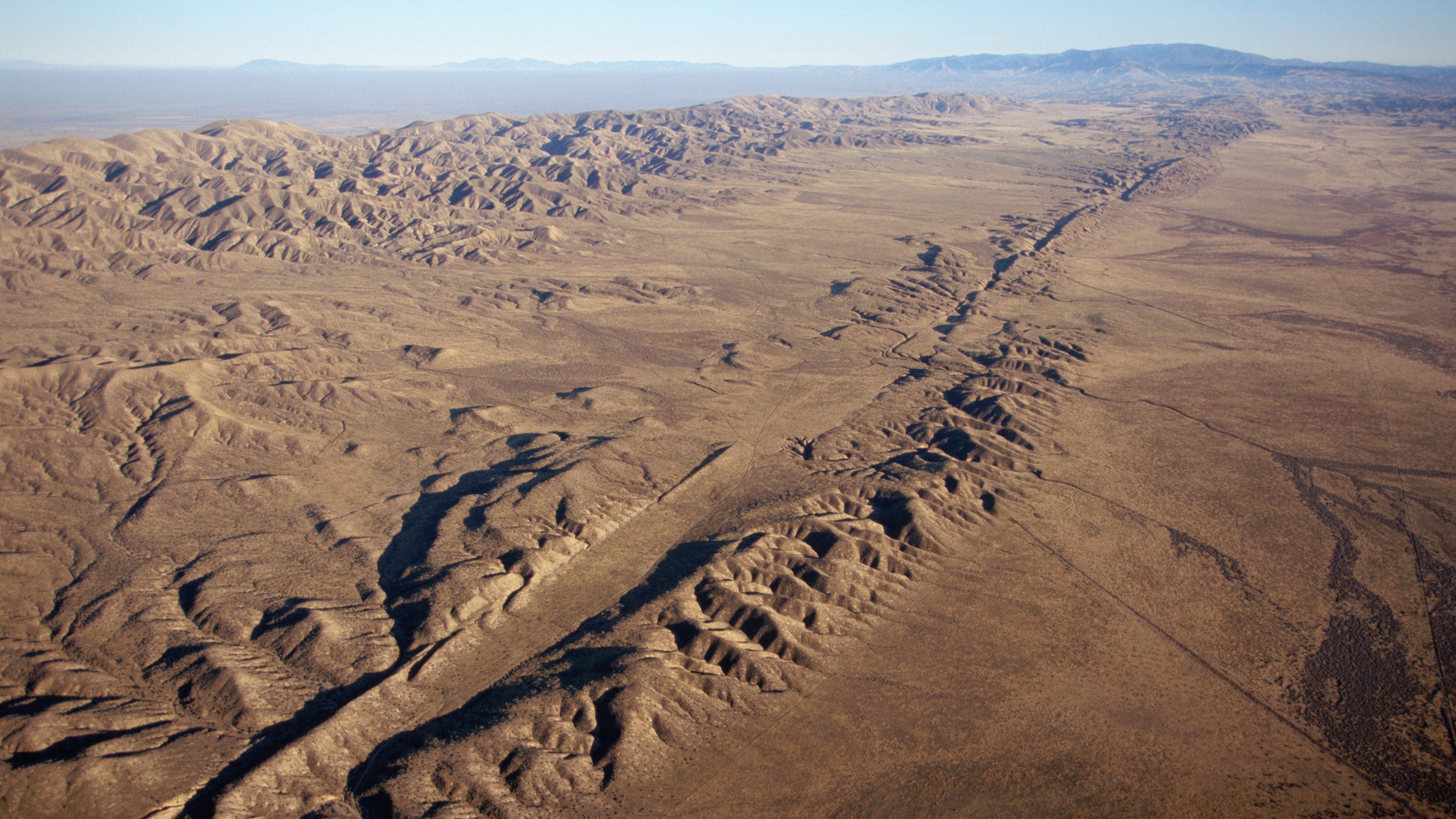
An aerial view of the San Andreas Fault in California. (Image credit: Kevin Schafer/Getty Images)
Along the San Andreas Fault, magnitude 7 or larger earthquakes occur, on average every 100 to 200 years, although the frequency of recurrence varies along the fault. The last major rupture in Southern California was the magnitude 7.9 Fort Tejon earthquake in 1857. In Venezuela, estimated slip rates suggest recurrence intervals of one to two centuries. The region experienced two devastating earthquakes in 1812, part of a multiple-rupture sequence that included events of magnitude 7.5, 7.2 and 6.5, and a 2018 study concluded that the Boconó Fault had already accumulated enough strain to generate another major earthquake.
However, these are statistical averages. The recurrence of large earthquakes is highly irregular and depends on a multitude of factors, many of which we still don't fully understand. So a major event could occur in 100 years — or even tomorrow.
Looking beyond individual faults
This uncertainty is precisely one of the reasons the Venezuelan seismic doublet is generating so much interest among seismologists.
"It is the kind of natural event that can sharpen and test the rupture-interaction concepts that paleoseismic models like ours can only infer indirectly," said Liliane Burkhard, a geologist and geophysicist at the University of Bern and first author of a recent study suggesting that the junction between the San Andreas and San Jacinto faults in Southern California is experiencing some of its highest tectonic stress levels in the past 1,000 years, told Live Science.
"Our Cajon Pass work relied on centuries of paleoseismic reconstructions to infer how stress evolves and whether ruptures can cross between fault systems," Burkhard told Live Science. But that doesn't give geologists real-time data, captured by seismic instruments, showing how different faults interact during quakes, she added.
The Venezuela doublet offers exactly that opportunity. The main lesson for California, Burkhard said, is that interactions between neighboring faults can play an important role in the evolution of large earthquakes.
"Whether it is Cajon Pass where the San Andreas and San Jacinto systems meet or the Boconó-San Sebastián in Venezuela, these are precisely the locations where single-fault hazard models break down because the real behavior depends on how stress is shared and transferred between adjacent structures," she said.
Many times the winner isn't the boxer who lands the hardest punch but the one who keeps punching for longer.
Julián García Mayordomo, senior scientist at the Geological and Mining Institute
Still, the two systems are quite different. The Venezuelan sequence represents a different type of cascading rupture than the one described in Burkhard's research. At Cajon Pass, the "earthquake gate" concept explores whether a single rupture can jump from one fault system to another during the same earthquake, over tens of seconds of rupture propagation along a continuous fault trace. The Venezuelan doublet, by contrast, "looks like two distinct ruptures on what may be two separate fault structures, triggered in close succession," Burkhard said.
For Burkhard, the Venezuelan earthquake reinforces the need for seismic hazard models to move beyond treating faults as isolated structures and instead represent them as interconnected networks. The challenge is particularly relevant in California, where roughly 300 active faults may interact in ways that traditional hazard models do not capture.
New Zealand has already incorporated this lesson. After the 2016 Kaikōura earthquake ruptured at least 12 faults in a single event, New Zealand revised its National Seismic Hazard Model to include complex multifault ruptures.
García Mayordomo argues that both Venezuela and the United States should incorporate these complex rupture scenarios into seismic hazard assessments and building codes. Earthquakes involving multiple faults can produce longer-lasting shaking that increases structural fatigue and, ultimately, the risk of collapse.
"It's like a boxing match," García Mayordomo said. "Many times the winner isn't the boxer who lands the hardest punch but the one who keeps punching for longer."
Even so, researchers cautioned against drawing sweeping conclusions from a single earthquake.
"Each earthquake gives us one possible scenario," Judith Hubbard, an earthquake scientist and structural geologist at Cornell University told Live Science. "The range of earthquake behaviors is wide."
Many volcano scientists spend their time monitoring volcanoes to predict if, or when, they’ll next erupt. The challenge for these scientists is to forecast the exact probability of an eruption and the moment it will occur.
To address this problem, a team of researchers developed an early-detection system to determine when to issue alerts about volcanic eruptions. Their motivation was that previous alert systems weren’t accurate enough because they couldn’t detect underground volcanic processes that occur right before an eruption.
From 2014 to 2023, the researchers conducted a series of tests to accurately detect temporary, low-frequency vibrations using an instrument called a seismometer. The researchers focused on these transient signals because they come from earthquakes and other ground phenomena, which scientists often rely on to predict volcanic eruptions. These phenomena include ground tilting caused by fracturing from the movement of magma and volcanic gases. The scientists named these signals the “Jerk” signals because they occur due to sudden movements.
The team set up their experiment at Piton de la Fournaise, a volcano at La Réunion Island off the east coast of Madagascar. They discovered the Jerk signals by detecting and analyzing mysterious short-term signals from existing and experimental seismic data. During real-time experiments, they detected signals 8 kilometers (about 5 miles) from the volcano at the Rivière de l’Est seismic station. These signals resulted from changes in ground elevation as magma moved, and they preceded eruptions by minutes and sometimes hours.
The researchers measured the Jerk signals in units of newton-meters per second, which conveys how fast physical changes occurred in or around the volcano. In addition to real-time experiments, the team checked the Jerk signals’ accuracy by analyzing the station’s past data to determine when these signals would have occurred before an eruption.
To avoid false alarms during their experiments, the researchers needed to distinguish between the signal amplitudes of ocean tides and the transient Jerk signals. So, they used computational software to predict the signals from ocean tides. This was necessary because the instruments that record ground phenomena are also sensitive to tidal movements.
The Jerk system sent its first automatic alarm in June 2014, 1 hour before the first volcanic tremor, signalling that magma was at the Earth’s surface. The team recorded the last signal in their study on July 2, 2023, 40 minutes before the eruption, at a slow 1.5 newton-meters per second. From 2014 to 2023, other Jerk detections occurred between a few minutes and up to 8 hours before an eruption.
To further assess the strength of the Jerk signals, the team examined previous eruption records at Piton de la Fournaise. They found that for the 24 eruptions between 1998 and 2010, a Jerk alarm would have gone off 83% of the time. Of the 48 eruptions that occurred between 1998 and 2023, including the eruptions during their real-time tests, about 42 Jerk alarms would have occurred. However, they found that the Jerk signals were more accurate during their real-time analysis than they would have been for the eruptions 20 years earlier.
Although the researchers successfully detected pre-eruption signals, they noted that the Jerk alarms occasionally arrived too late due to the data processing time, which takes at least 10 to 15 minutes. They reported 2 late alarms: one on June 11, 2019, and the other on February 10, 2020. Therefore, after 10 years of tracking the Jerk signals, the team evaluated their success rates at 22 successful alarms out of 24 eruptions, for a 92% positive rate.
Before using the Jerk signals, many volcanologists struggled to predict the exact moment a volcano erupts. The team concluded that, in addition to the usual methods for detecting pre-eruption earthquakes, observatory scientists could now use Jerk signals to confidently notify authorities in advance of volcanic eruptions, so they can alert people living near volcanoes worldwide.
The San Andreas and San Jacinto fault systems are at their highest levels of tectonic stress in 1,000 years, raising the threat of a major, imminent earthquake that could devastate Southern California, a new study finds.
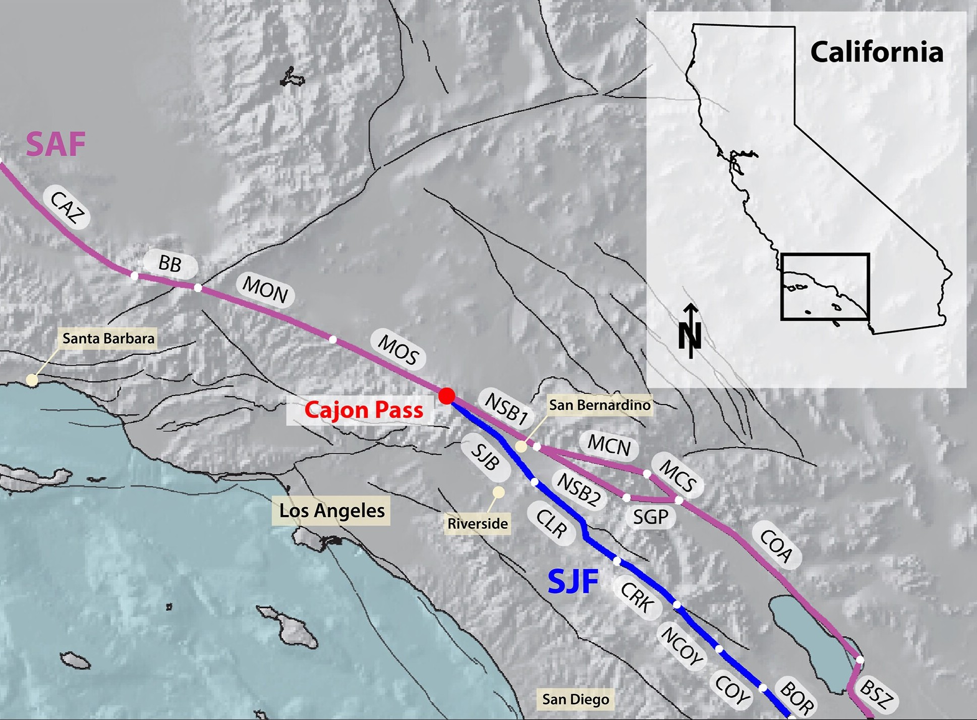
The faults could rupture separately or together, thanks to an "earthquake gate" between them at Cajon Pass, where the San Jacinto fault splits from the main trace of the San Andreas fault. Researchers discovered that Cajon Pass can prevent or facilitate earthquakes moving between the faults, depending on how similar their stress levels are at the time of rupture.
And right now, the San Andreas and San Jacinto faults appear to have comparable, extremely elevated stress levels, potentially spelling trouble for Los Angeles, San Bernardino, Riverside and the Coachella Valley, the team warned.
Cajon Pass, where the San Andreas and San Jacinto faults connect, is an "earthquake gate" that can facilitate the spread of ruptures. (Image credit: Burkhard et al., 2026. JCR Solid Earth. (CC BY 4.0))
"Our results show that stress levels on multiple fault segments are now at or above the highest values seen in the past millennium and that the region may be capable of a large through-going rupture involving both fault systems," study first author Liliane Burkhard, a planetary geologist at the University of Bern in Switzerland and at the University of Hawaii at Manoa, said in a statement.
The San Andreas and San Jacinto faults have caused 36 earthquakes with magnitudes of 6.4 or above in the past 1,000 years. Southern California's last "big one" was a magnitude 7.9 event in 1857, when a 205-mile (330 kilometers) segment of the San Andreas fault slipped horizontally between Parkfield and Cajon Pass. That rupture did not propagate through Cajon Pass, but a similar megaquake in 1812 did, suggesting this could happen again in what is now a much more built-up and densely populated environment, according to the study.
To estimate this risk, Burkhard and her colleagues built a model replicating the last 1,000 years of major earthquake activity along the southern San Andreas and San Jacinto fault systems.
The researchers used observations such as tree-ring records and age data from sediments that have been displaced to reconstruct Southern California's earthquake history. They fed this information into the model, which simulated the accumulation, release and propagation of tectonic stress in the San Andreas and San Jacinto faults.
The results, published June 3 in the Journal of Geophysical Research: Solid Earth, suggest the San Andreas and San Jacinto faults are primed for an Earth-shattering rupture, which may involve the earthquake gate at Cajon Pass opening to unleash more destruction than a single-fault event would on its own.
If a rupture were to occur along the two branches of the San Andreas fault that connect at Cajon Pass, it would be a joint rupture, according to the study. If both branches of the San Andreas fault and the San Jacinto fault were involved, this would constitute a tripartite rupture.
The chance of each event happening and the timing of a potential rupture are unknown, but understanding how much stress is building up inside the system could help planners and policymakers prepare for whatever comes next, Burkhard said.
"What we can say is that the system is critically stressed, and that physics-based models like this one give us a clearer picture of the range of scenarios we should be prepared for," she said. "That information matters for hazard assessment, infrastructure planning, and emergency preparedness."
The researchers say their model could apply to other fault junctions and be used as a tool for hazard assessment globally. "We are using rigorous, quantitative science to better understand the risk facing millions of people," Burkhard said.
Scientists have confirmed a rare “impossible” earthquake deep beneath Utah, revealing a hidden source of seismic activity inside Earth’s mantle. Nearly five decades after a puzzling earthquake struck deep beneath northern Utah, scientists have confirmed that the event was real and part of a rare category of earthquakes that occur much deeper underground than researchers [...]
In 2011, miles of rock shifted deep underwater in the Japan Trench, causing an earthquake that deformed the seafloor and caused a devastating tsunami. Off the Eastern Coast of the Tōhoku region in Japan, a huge piece of the Earth’s crust carrying the Pacific Ocean, known as a tectonic plate, is forcing itself beneath Japan and into the Earth’s interior. Researchers think rock from this plate pushed against rock far beneath Japan, building pressure until it became too great. The lower plate slipped, spreading energy from the slip site and causing the earthquake.
Plate slip can cause 2 types of outcomes. The first occurs kilometers deep in the Earth’s crust, causing earthquakes too small to trigger tsunamis. The second type causes extreme slip events that begin deep in the crust, like the 2011 event that extended into the Japan Trench and warped the seafloor. The moving seafloor displaces seawater, causing a tsunami. These events are referred to as slip-to-the-trench style earthquakes.
Researchers think this phenomenon is not unique to 2011, as Japan has a long history of tsunami-causing earthquakes. Charlotte Pizer and colleagues investigated sediment from the Japan Trench to unearth the geologic history of slip-to-the-trench style earthquakes.
In between earthquakes, Japanese islands continuously shed sediment that fills the trench, forming horizontal layers. Slip-to-the-trench earthquakes bend and fold these layers. The team hypothesized that if they found these folds in the Japan Trench and dated them, they could catalogue the record of slip-to-the-trench style earthquakes in the area.
Earthquakes like these occur repeatedly, meaning that younger ones can erase folds caused by older ones. To account for this overprinting, the researchers chose a study site within the Japan Trench about 100 kilometers (60 miles) north of where the most severe earthquakes occur. This site is only mildly deformed by slip-to-the-trench earthquakes since it’s so far from their source, making it easier for the team to identify individual events.
Pizer and her group pieced together data collected from this site by previous researchers to reconstruct Japan’s earthquake history. They compiled 3 main types of data. Two of these were images of sediment layers in the trench constructed from reflections of vibrations sent into the ground, called seismic profiles.
The first seismic profile captured the full trench, over 1 kilometer deep (about 0.6 miles), at 5-meter (16-feet) resolution. Using this method, any layers smaller than 5 meters thick won’t appear in the image. The second seismic profile captured only the top 40 meters (130 feet) of sediment, but could detect layers as thin as 10 centimeters (4 inches).
The final type of data they used came from a 36-meter (120-foot) long cylinder of sediment extracted from the bottom of the trench, called a sediment core. Researchers in the past tied layers within this sediment core to historic earthquake events. They showed that it recorded 2 specific earthquakes in the area, the Kyotoku earthquake of 1454 CE, and the Jogan earthquake of 869 CE, both of which likely caused tsunamis.
Pizer’s team could observe the depth of the Kyotoku and Jogan earthquake layers taken from the sediment core in their high-resolution seismic profile of the trench. In these high-resolution data, they noticed that deformation occurred in the sediment up to the layer marking the Jogan earthquake, but not above it, meaning deformation of the trench happened during this 869 CE event.
The high-resolution data were only able to image sediments from recent earthquakes since 869 CE, but the low-resolution profile, which imaged the full trench, was able to capture the deeper, older record. When they looked deeper into the trench sediment, the researchers noticed that deformation from the 869 CE event had spread from where the tectonic plate is colliding with Japan. They saw at least 6 more similarly deformed layers, implying each was its own slip-to-the-trench event, although the dates of these events are unknown.
Pizer and colleagues concluded that slip-to-the-trench earthquakes are long-standing, common events in the Japan Trench. They hope future scientists will continue to research this site to better assess tsunami risks in Japan.

 Login