❌

Normal view

How do ice sheets melt?

29 June 2026 at 12:00

Nearly 170 billion tons of ice melt off the Greenland Ice Sheet every year, but scientists don’t fully understand the process by which this melting occurs. Researchers in the past suggested that liquid water forms at the glacier’s surface, where warm air and sunlight melt the ice. This meltwater travels down through cracks in the glacier and along the bedrock beneath it and flows out to sea. 

However, some scientists view this model as too simple because it assumes water only flows downward and ignores how temperature affects water movement. They argue that an oversimplified melting model is unreliable for predicting how future ice sheets will behave.

One group of researchers tested this by investigating how water movement across Greenland is controlled by lakes beneath the ice sheet, called subglacial lakes. They monitored a newly discovered subglacial lake using high-resolution satellite images taken from 2012 to 2019 and 3D surface maps generated from the images. They focused on ice sheet changes from July 22 to August 1, 2014, during a suspected subglacial lake drainage event. A drainage event is like a water balloon that’s too full, bursting from excess pressure. 

They examined images of the Greenland ice sheet taken from Landsat-8, 3D surface maps from the Polar Geospatial Center, and data from ICESat and ICESat-2 taken in the summer of 2014. Based on these data, the researchers identified a 2-square-kilometer (0.8-square-mile) region of ice rising 10 to 15 meters (about 30 to 50 feet), forming a dome on the ice sheet’s surface. They suggested that this dome formed when a large, meltwater-fed lake developed on the bedrock beneath the ice sheet, pushing the ice upward. 

They also saw that on July 22, 2014, the dome began to collapse. Over the next 10 days, it dropped by 85 meters (about 280 feet), forming a basin. Using the dome’s dimensions, the researchers estimated that 90 million cubic meters, or about 3 billion cubic feet, of water drained from the lake at an average rate of 100 cubic meters, or about 3500 cubic feet, per second over the 10 days. This is roughly equivalent to 36,000 Olympic swimming pools draining at a rate of 1 pool every 25 seconds! 

The researchers also found that during the collapse, 40-meter-high (130-foot) ice blocks were uprooted about 1 kilometer (0.6 mile) downstream from the basin, followed by 6 square kilometers (about 2 square miles) of smooth ice. The researchers hypothesized that these features formed when water burst through the ice, flowed along its surface, and then reentered the ice sheet.

Next, they used data from Landsat 5, Landsat 9, the National Snow and Ice Data Center, and the U.S. Geological Survey to demonstrate that the drainage event also affected the surrounding environment. When the water reentered the ice sheet, it flowed beneath the Harding Glacier downstream. This influx of fast-moving water reduced pressure at the glacier’s base, slowing its movement. Simultaneously, the increased drainage beneath the Harding Glacier caused 500 to 600 meters (about 1,600 to 2,000 feet) of ice to break off its end. 

In response to these changes, the researchers hypothesized that subglacial waters rose to the surface rather than sinking to the bedrock because the ice sheet was frozen to it. To test this, they simulated temperatures at the base of the ice sheet using computer-generated thermal models. They input a range of likely bedrock temperatures and ice thicknesses to simulate possible conditions under the ice sheet. They found that all the simulations predicted the glacier’s base would remain below -5°C (23°F). At such low temperatures, the ice would be frozen to the bedrock before subglacial water could drain out. Since water couldn’t flow under the glacier, it was forced to travel upward. 

The researchers used these findings to develop a new conceptual model of how glacial meltwater moves. First, surface ice melts and flows into a subglacial lake. As meltwater accumulates, pressure builds at the base of the ice sheet, forming a dome on the surface. A drainage event causes the dome to collapse. As water moves downward through the glacier, it is blocked from reaching the base because the ice is frozen to the bedrock. The water then moves upward, bursts through the surface, travels across it, and eventually reenters the glacier before draining to the ocean.

The team concluded that water movement above, through, and below glaciers is interconnected. Destructive upward flow of meltwater, followed by downward flow beneath glaciers, can weaken ice sheet structure and alter downstream glacier dynamics. Their work highlights the need for more scientists to consider the processes driving glacial ice loss.

The post How do ice sheets melt? appeared first on Sciworthy.

When glaciers retreat, microbes take over

15 June 2026 at 12:00

As our world is rapidly reshaped by climate change, glaciers have retreated and revealed new swaths of bare land. Throughout the coming decades to centuries, this rocky ground will become dappled with lichens and scrub, eventually giving rise to newborn forests in a process known as ecological succession. 

Ecologists have mapped out the stages of ecological succession for plant communities, observing which species are the first to colonize land and how these pioneer species promote secondary growth. Yet before any plants sink their roots into the soil, it is populated by thriving communities of single-celled microbes that prepare it for further habitation. Scientists study how these microbial communities arise to understand how healthy ecosystems develop.

Newly exposed land is nutrient-poor and subject to large temperature fluctuations, so the first species to settle there must overcome these challenges. Pioneer plant species are often habitat generalists, meaning they can thrive under a variety of environmental conditions. However, all plants convert water and sunlight into carbon and energy. Microbes can use many different energy sources, and often contain genes for multiple metabolisms in their genomes. Therefore, researchers wondered whether pioneer microbes could also be defined by their metabolic flexibility. 

A team of scientists based at Monash University in Australia tested this hypothesis by studying land left in the wake of 2 retreating glaciers: one on an island off the coast of Antarctica and one in the Swiss Alps. The researchers sampled soils along a path from the tip of the glacier outward, which had been exposed to the air for different amounts of time. By comparing the microbial communities within these soils, the researchers could track the different stages of ecological succession after glacial retreat.

The researchers extracted DNA from the soils and analyzed it using 2 sequencing methods. First, they sequenced a gene called 16S rRNA, which is like a microbial fingerprint for the different species present. They used this method to understand the diversity of these communities and track their species overlap, helping them to identify habitat generalists that thrived under different soil conditions. 

To understand the metabolic flexibility of these microbes, the researchers used a second method, known as metagenomics, which sequences all of the DNA in a sample rather than just a single gene. They used these data to reconstruct the entire genomes of microbes present in the soils, providing information on what kinds of metabolic activities they were capable of. The team also measured chemicals like ammonium and sulfide in the soils, as well as atmospheric gases like methane and carbon monoxide, to assess how the microbes used these compounds for growth.

The researchers found microbes inhabiting even the youngest soils, demonstrating the speed at which life takes hold in new environments. The abundance of microbes increased by approximately 8-fold in older soils, alongside a similar rise in species diversity, indicating that complex communities persisted over time. They also found the metabolic capabilities of microbes inhabiting Antarctic and Swiss glacial soils to be remarkably similar, suggesting common selective pressures drove the establishment of these new ecosystems.

They were surprised to discover that the most abundant microbes in younger soils were habitat specialists that were rare in older soils. These pioneer microbes, while still metabolically flexible, had adapted to utilize meager energy sources like atmospheric trace gases, including hydrogen, methane, and carbon monoxide. Many of these microbes could also derive energy from chemicals that dissolved out of rocks, like inorganic sulfur compounds. The researchers proposed that pioneer microbes could quickly take advantage of newly opened ecological niches, like soils exposed during a glacier’s retreat, because of their efficiency at using scant resources. 

They found that habitat generalists, on the other hand, tended to dominate older soils.  This result suggested that the habitat specialists were eventually outcompeted by the slow and steady growth of the habitat generalists in a real-life turtle-and-hare race.

The team concluded that using multiple growth strategies helps microbes adapt to new environments. However, they acknowledged that ecological succession could occur differently in other landscapes, such as in the aftermath of volcanic eruptions, meteorite impacts, or forest fires. They suggested that future researchers work to uncover how microbial communities lay the groundwork across these diverse ecosystems. 

The post When glaciers retreat, microbes take over appeared first on Sciworthy.

Tyndall’s Trail of Bergs

10 June 2026 at 05:01
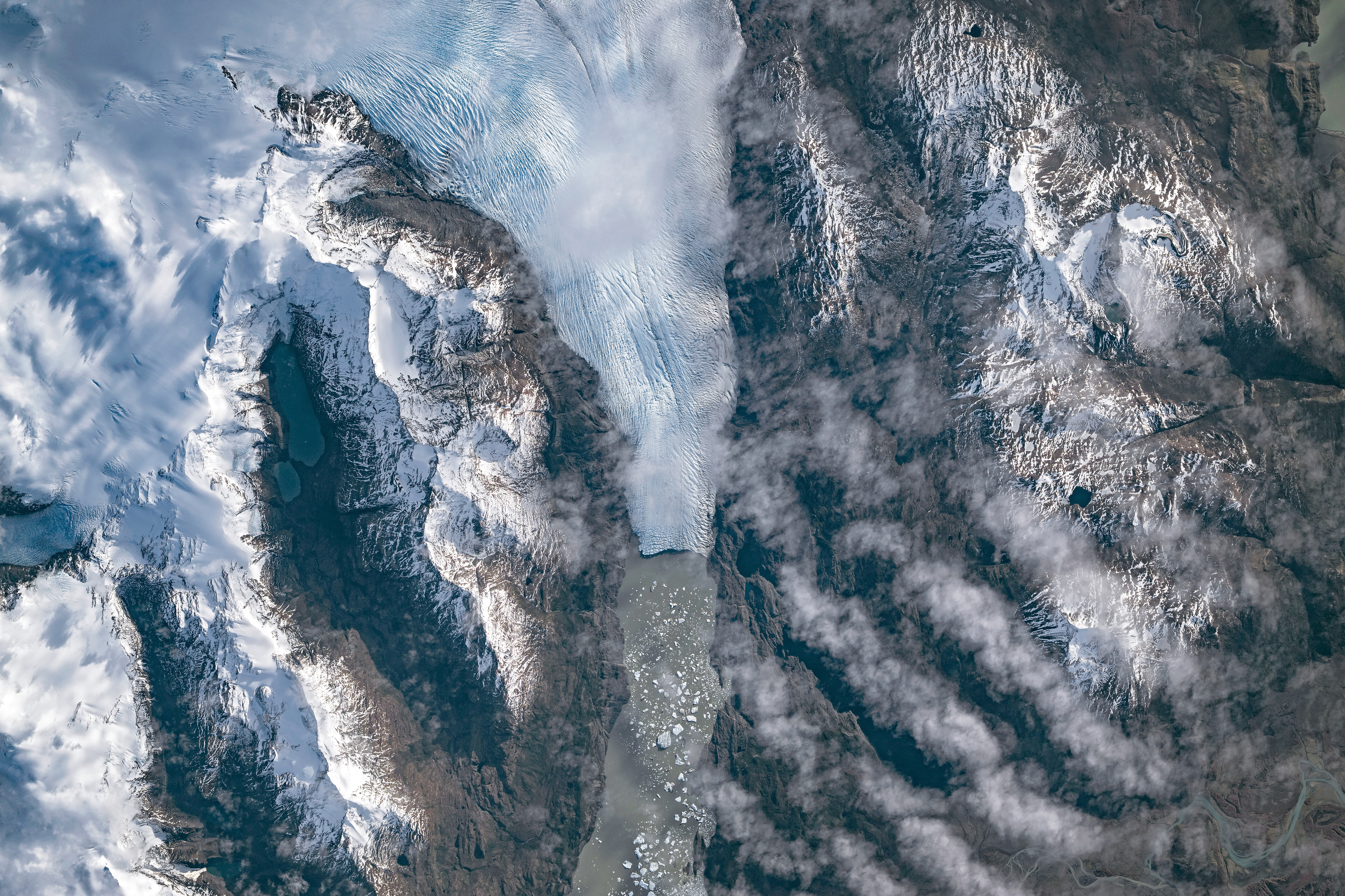
A top-down photo shows a glacier running from north to south amid snowy, mountainous terrain. The glacier flows into a narrow lake where many small icebergs are visible floating on the water.
May 10, 2026

The Southern Patagonian Icefield is the largest expanse of ice in the Southern Hemisphere outside of Antarctica. The mass of glacial ice extends hundreds of kilometers along the spine of the Andes, feeding dozens of dynamic outlet glaciers that grind their way down from higher elevations. Many of these rivers of ice terminate in the sea or in proglacial lakes.

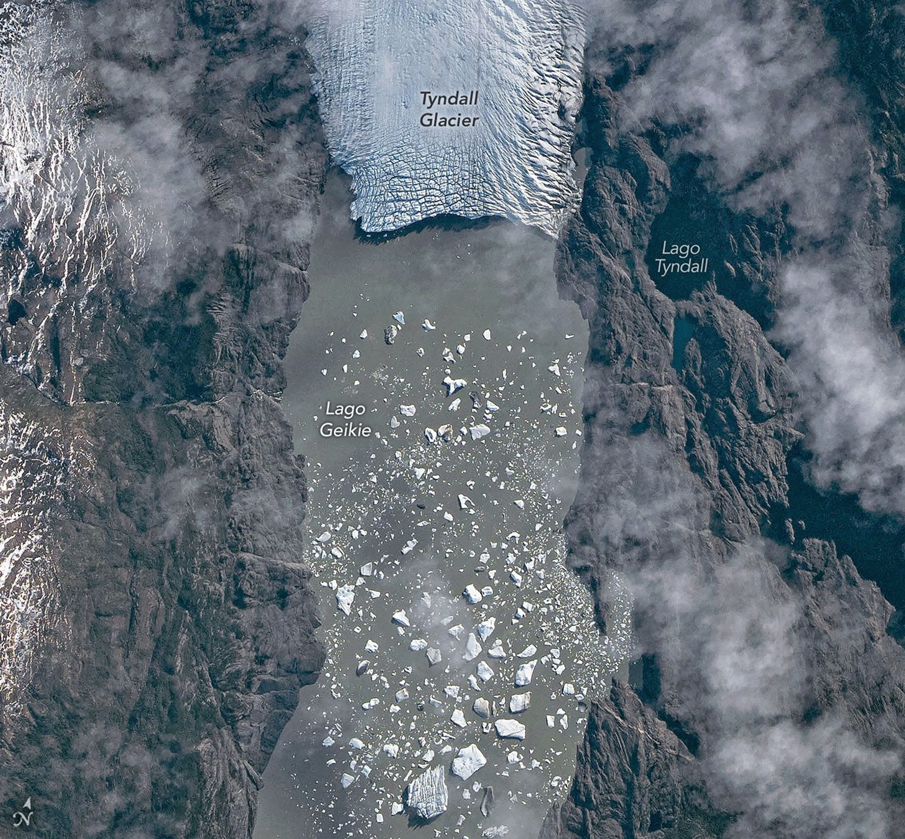
An astronaut aboard the International Space Station photographed one of these glaciers—Tyndall Glacier in southern Chile—through a layer of ethereal clouds on May 10, 2026. Fragments of ice that had calved off its terminus were visible floating on Lago Geikie.

Like most Patagonian glaciers, Tyndall has been shrinking since the end of the Little Ice Age about 150 years ago. Lago Geikie formed at Tyndall’s terminus around 1940, according to glaciologist Mauri Pelto of Nichols College, and gradually expanded as the ice retreated. Part of the glacier previously terminated in Lago Tyndall to the east, but thinning ice cut off that outlet by 2010, Pelto said. (The ice’s retreat also exposed bedrock along its eastern edge that contains scores of ichthyosaur fossils.)

Along with thinning, ice calving off the glacier’s front has reduced its volume. Tyndall has lost 2.2 kilometers (1.4 miles) in length since November 2022, Pelto said, following about a decade of limited retreat with considerable thinning. A significant calving event in March and April 2023 contributed to the recent uptick in ice retreat. During that time, satellites observed several large icebergs breaking away from Tyndall’s terminus.

Austral autumn in 2026 was a time of active calving retreat at Tyndall (and some neighboring glaciers), Pelto said, albeit more incremental than three years prior. “The substantial crevasses crisscrossing the glacier near the calving front lead to many smaller icebergs,” he said. On the other hand, larger tabular icebergs tend to form when there are fewer deep crevasses near the terminus and the glacier’s ice is thinner.

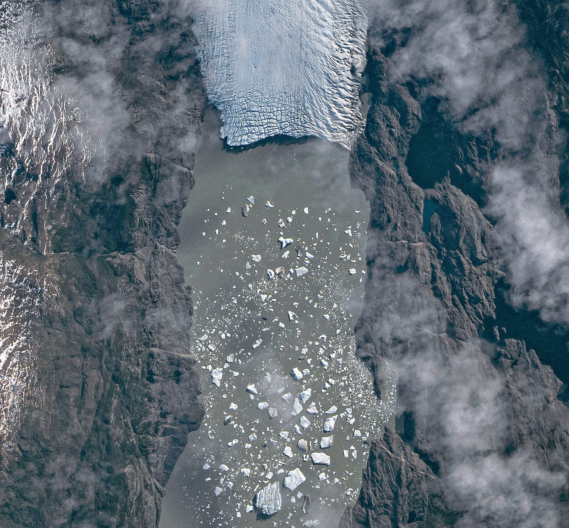
A top-down photo shows a detailed view of the leading edge of a glacier terminating in a lake. The glacial ice is heavily crevassed with intersecting linear features.
May 10, 2026

The ice cliff at the terminus casts a substantial shadow, which can help scientists estimate the height of the glacier’s front. Pelto’s calculations, using information about the Sun’s position provided with the image, indicate that Tyndall’s front loomed 30–40 meters (100–130 feet) above the lake surface in May 2026. Observations from orbit, including astronaut photographs, can help scientists monitor and understand glaciers in remote regions where ground-based observations are scarce.

As for what comes next for Tyndall, Pelto expects many more small icebergs to continue breaking off, given the heavily crevassed appearance of the calving front. “Look for a burst of iceberg production next fall.”

Astronaut photograph ISS074-E-582898 was acquired on May 10, 2026, with a Nikon Z9 digital camera using a focal length of 560 millimeters. It is provided by the ISS Crew Earth Observations Facility and the Earth Science and Remote Sensing Unit at NASA Johnson Space Center. The image was taken by a member of the Expedition 74 crew. The image has been cropped and enhanced to improve contrast, and lens artifacts have been removed. The International Space Station Program supports the laboratory as part of the ISS National Lab to help astronauts take pictures of Earth that will be of the greatest value to scientists and the public, and to make those images freely available on the Internet. Additional images taken by astronauts and cosmonauts can be viewed at the NASA/JSC Gateway to Astronaut Photography of Earth. Story by Lindsey Doermann.

Downloads

A top-down photo shows a glacier running from north to south amid snowy, mountainous terrain. The glacier flows into a narrow lake where many small icebergs are visible floating on the water.

May 10, 2026 (wide)

JPEG (11.19 MB)

A top-down photo shows a detailed view of the leading edge of a glacier terminating in a lake. The glacial ice is heavily crevassed with intersecting linear features.

May 10, 2026 (detailed)

JPEG (3.43 MB)

References & Resources

You may also be interested in:

Stay up-to-date with the latest content from NASA as we explore the universe and discover more about our home planet.

Record-Setting Retreat of Hektoria Glacier
5 min read

Scientists relied on satellite data to understand how the Antarctic glacier lost so much ice so rapidly.

Article
Stonebreen’s Beating Heart
3 min read

The glacier in southeastern Svalbard pulses with the changing seasons, speeding up and slowing its flow toward the sea.

Article
Cañon Fiord’s Whirling Waters
3 min read

During the 2022 summer melt season, sediment plumes and fractured sea ice traced swirling eddies in a branch of the…

Article

The post Tyndall’s Trail of Bergs appeared first on NASA Science.

Tyndall’s Trail of Bergs

10 June 2026 at 05:01
A top-down photo shows a glacier running from north to south amid snowy, mountainous terrain. The glacier flows into a narrow lake where many small icebergs are visible floating on the water.
May 10, 2026

The Southern Patagonian Icefield is the largest expanse of ice in the Southern Hemisphere outside of Antarctica. The mass of glacial ice extends hundreds of kilometers along the spine of the Andes, feeding dozens of dynamic outlet glaciers that grind their way down from higher elevations. Many of these rivers of ice terminate in the sea or in proglacial lakes.

An astronaut aboard the International Space Station photographed one of these glaciers—Tyndall Glacier in southern Chile—through a layer of ethereal clouds on May 10, 2026. Fragments of ice that had calved off its terminus were visible floating on Lago Geikie.

Like most Patagonian glaciers, Tyndall has been shrinking since the end of the Little Ice Age about 150 years ago. Lago Geikie formed at Tyndall’s terminus around 1940, according to glaciologist Mauri Pelto of Nichols College, and gradually expanded as the ice retreated. Part of the glacier previously terminated in Lago Tyndall to the east, but thinning ice cut off that outlet by 2010, Pelto said. (The ice’s retreat also exposed bedrock along its eastern edge that contains scores of ichthyosaur fossils.)

Along with thinning, ice calving off the glacier’s front has reduced its volume. Tyndall has lost 2.2 kilometers (1.4 miles) in length since November 2022, Pelto said, following about a decade of limited retreat with considerable thinning. A significant calving event in March and April 2023 contributed to the recent uptick in ice retreat. During that time, satellites observed several large icebergs breaking away from Tyndall’s terminus.

Austral autumn in 2026 was a time of active calving retreat at Tyndall (and some neighboring glaciers), Pelto said, albeit more incremental than three years prior. “The substantial crevasses crisscrossing the glacier near the calving front lead to many smaller icebergs,” he said. On the other hand, larger tabular icebergs tend to form when there are fewer deep crevasses near the terminus and the glacier’s ice is thinner.

A top-down photo shows a detailed view of the leading edge of a glacier terminating in a lake. The glacial ice is heavily crevassed with intersecting linear features.
May 10, 2026

The ice cliff at the terminus casts a substantial shadow, which can help scientists estimate the height of the glacier’s front. Pelto’s calculations, using information about the Sun’s position provided with the image, indicate that Tyndall’s front loomed 30–40 meters (100–130 feet) above the lake surface in May 2026. Observations from orbit, including astronaut photographs, can help scientists monitor and understand glaciers in remote regions where ground-based observations are scarce.

As for what comes next for Tyndall, Pelto expects many more small icebergs to continue breaking off, given the heavily crevassed appearance of the calving front. “Look for a burst of iceberg production next fall.”

Astronaut photograph ISS074-E-582898 was acquired on May 10, 2026, with a Nikon Z9 digital camera using a focal length of 560 millimeters. It is provided by the ISS Crew Earth Observations Facility and the Earth Science and Remote Sensing Unit at NASA Johnson Space Center. The image was taken by a member of the Expedition 74 crew. The image has been cropped and enhanced to improve contrast, and lens artifacts have been removed. The International Space Station Program supports the laboratory as part of the ISS National Lab to help astronauts take pictures of Earth that will be of the greatest value to scientists and the public, and to make those images freely available on the Internet. Additional images taken by astronauts and cosmonauts can be viewed at the NASA/JSC Gateway to Astronaut Photography of Earth. Story by Lindsey Doermann.

Downloads

A top-down photo shows a glacier running from north to south amid snowy, mountainous terrain. The glacier flows into a narrow lake where many small icebergs are visible floating on the water.

May 10, 2026 (wide)

JPEG (11.19 MB)

A top-down photo shows a detailed view of the leading edge of a glacier terminating in a lake. The glacial ice is heavily crevassed with intersecting linear features.

May 10, 2026 (detailed)

JPEG (3.43 MB)

References & Resources

You may also be interested in:

Stay up-to-date with the latest content from NASA as we explore the universe and discover more about our home planet.

Record-Setting Retreat of Hektoria Glacier

5 min read

Scientists relied on satellite data to understand how the Antarctic glacier lost so much ice so rapidly.

Article

Stonebreen’s Beating Heart

3 min read

The glacier in southeastern Svalbard pulses with the changing seasons, speeding up and slowing its flow toward the sea.

Article

Cañon Fiord’s Whirling Waters

3 min read

During the 2022 summer melt season, sediment plumes and fractured sea ice traced swirling eddies in a branch of the…

Article
❌