❌

Normal view

NASA Uses Subscale Aircraft to Accelerate Flight Innovation

15 July 2026 at 22:56
4 Min Read

NASA Uses Subscale Aircraft to Accelerate Flight Innovation

A white, blue, and red probe attached to a rotor with four blades flies in the blue sky, just above the Moon.
An atmospheric probe model attached upside down to a quad rotor remotely piloted aircraft ascends with the Moon visible on Oct. 22, 2024. The quad rotor aircraft released the probe above Rogers Dry Lake, a flight area adjacent NASA’s Armstrong Flight Research Center in Edwards, California. The probe was designed and built at the center.
Credits: NASA/Steve Freeman

Testing new aerospace concepts in flight remains one of NASA’s most effective ways to advance knowledge and reduce risk.

The Dale Reed Subscale Flight Research Laboratory at NASA’s Armstrong Flight Research Center in Edwards, California, supports this mission by using small, remotely piloted and autonomous aircraft as cost‑effective platforms to mature innovative ideas, accelerate learning, and enable smoother transitions to full‑scale flight.

When experiments require a flight platform, several NASA remotely piloted aircraft are available: the Alta‑X quadrotor; the Dryden Remotely Operated Integrated Drone (DROID) with its 10‑foot wingspan; and the Multi‑Use Cub, a 14‑foot‑span fixed‑wing aircraft with an expandable payload capacity for flight experiments. For electric vertical takeoff and landing testing, the HQ‑90 quadrotor provides an additional option.

Once aircraft and experiments are cleared for operations, laboratory pilots support the mission, including ground operations and flight activities.

One man manages engine speed with a hand-held controller, while another firmly holds the subscale aircraft in place.
Justin Link, left, holds the subscale aircraft in place, while Justin Hall manages engine speed during preliminary engine tests on Friday, Sept. 12, 2025, at NASA’s Armstong Flight Research Center in Edwards, California. Link is a pilot for small uncrewed aircraft systems at the center’s Dale Reed Subscale Flight Research Laboratory and Hall is the chief pilot.
NASA/Christopher LC Clark

Flight expertise

Each staff member serves as an experienced and certified subscale aircraft pilot and is prepared to fly unique one-of-a-kind or modified commercial aircraft wherever the mission requires.

NASA’s FireSense project conducted flights in the Geneva State Forest, located about 100 miles south of Montgomery, Alabama. NASA Armstrong flight research staff integrated the instrument onto an Alta-X drone and tested the system before deployment. Two team members then transported the drone and sensor to the forest, prepared the vehicle for flight, and operated it during the mission. The NASA sensor was flown on the drone to demonstrate how remotely piloted aircraft can gather localized weather data that influences smoke movement and fire behavior. This information may help operational agencies improve wildfire decision-making and better allocate firefighters and resources.

Other missions occur closer to NASA Armstrong, such as the Enhancing Parachutes by Instrumenting the Canopy (EPIC) project. EPIC involved air‑launching a capsule containing a parachute and flexible sensor from the Alta‑X. Laboratory staff piloted the flights, supported flight operations, and worked with the EPIC team to design and integrate the parachute‑drop mechanism and safety system into the aircraft.

These tests demonstrated that a flexible sensor could help researchers study supersonic parachutes. Continuation of this work can help fill gaps in computer models, making supersonic parachutes safer and more reliable for delivering science instruments and payloads to Mars.
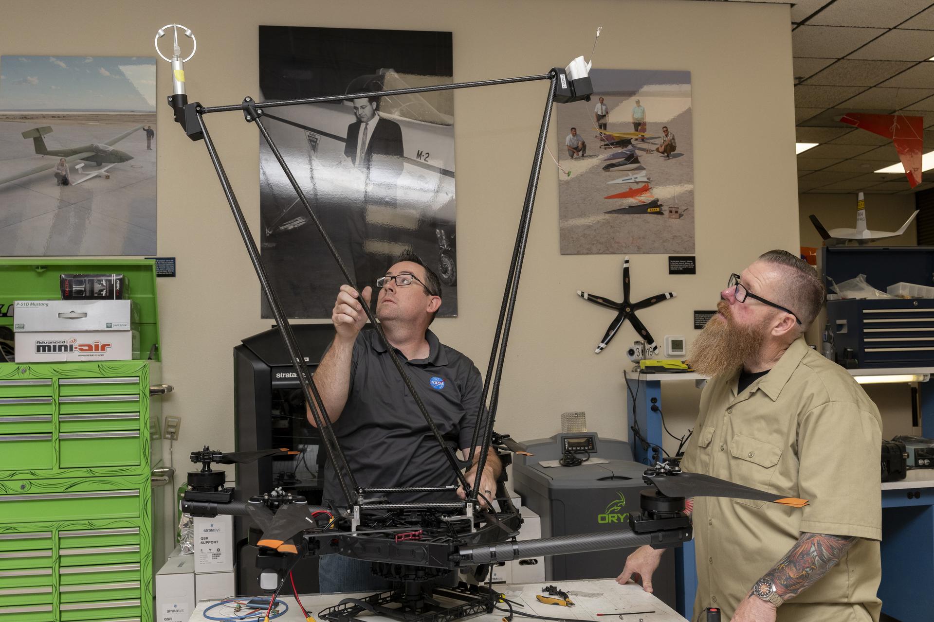
Two men integrate instruments onto a drone.
Justin Link, left, pilot for small uncrewed aircraft systems, and Justin Hall, chief pilot for small uncrewed aircraft systems, install weather instruments on NASA’s Alta X drone at the agency’s Armstrong Flight Research Center in Edwards, California. Members of the center’s Dale Reed Subscale Flight Research Laboratory used the Alta X to support the agency’s FireSense project in March 2025 for a prescribed burn in Geneva State Forest, which is about 100 miles south of Montgomery, Alabama.
NASA/Steve Freeman

Advancing challenging research

The Dale Reed Subscale Flight Research Laboratory uses rapid design and testing capabilities to help small aircraft fly big ideas. These concepts could lead to future breakthroughs that support NASA’s missions across aeronautics, science, and exploration.

For decades, NASA and its partners have advanced Automatic Collision Avoidance Technology. The research demonstrated an autopilot could detect and recover from an imminent ground collision – a capability now helping save lives in high‑performance U.S. military jets. NASA Armstrong had key roles in that work and developed a simplified version, the Automatic Ground Collision Avoidance System, which was installed on the DROID for testing.

The system demonstrated on the DROID — developed to assist general aviation pilots as well as remotely piloted and autonomous aircraft — performed well and led to further research toward a version that provides alerts and steering cues. The NASA Armstrong Technology Transfer Office is working to license the technology for U.S. businesses to develop the system as a commercial product.

The Prandtl‑D (Preliminary Research Aerodynamic Design to Lower Drag) flying‑wing glider was also designed, fabricated, and flown at NASA Armstrong. Researchers found that its twisted wing design could reduce drag and generate thrust at the wingtips, advancing concepts that may support greater fuel economy for future aircraft. The original Prandtl‑D is now part of the Smithsonian National Air and Space Museum collection in Washington, and the Prandtl-D3 is at the California Science Center in Los Angeles. Researchers continue developing the next generation of the design in the laboratory.

A wide range of capabilities in the laboratory help transform promising concepts into flight-ready test structures. These include rapid prototyping using traditional and advanced 3D manufacturing techniques, as well as composite and conventional fabrication processes. The team of engineers and technicians also provides custom component design and specialized fabrication to meet unique research needs.

The laboratory supports electrical and mechanical design, hardware and software integration, and the safety and flight-readiness processes required for successful missions. Additional technical facilities, such as the Experimental Fabrication Branch and the Environmental Laboratory at NASA Armstrong, further enhance these capabilities. Together, they support development, testing, and validation activities that advance NASA’s aeronautics and exploration goals.

Deborah Jackson, Al Bowers and Abbigail Waddell successfully launch the subscale Prandtl-D 3C glider.
NASA

Share

Details

Last Updated
Jul 15, 2026
Editor
Dede Dinius
Contact

The post NASA Uses Subscale Aircraft to Accelerate Flight Innovation appeared first on NASA Science.
NASA Uses Subscale Aircraft to Accelerate Flight Innovation

15 July 2026 at 22:56
4 Min Read

NASA Uses Subscale Aircraft to Accelerate Flight Innovation

A white, blue, and red probe attached to a rotor with four blades flies in the blue sky, just above the Moon.
An atmospheric probe model attached upside down to a quad rotor remotely piloted aircraft ascends with the Moon visible on Oct. 22, 2024. The quad rotor aircraft released the probe above Rogers Dry Lake, a flight area adjacent NASA’s Armstrong Flight Research Center in Edwards, California. The probe was designed and built at the center.
Credits: NASA/Steve Freeman

Testing new aerospace concepts in flight remains one of NASA’s most effective ways to advance knowledge and reduce risk.

The Dale Reed Subscale Flight Research Laboratory at NASA’s Armstrong Flight Research Center in Edwards, California, supports this mission by using small, remotely piloted and autonomous aircraft as cost‑effective platforms to mature innovative ideas, accelerate learning, and enable smoother transitions to full‑scale flight.

When experiments require a flight platform, several NASA remotely piloted aircraft are available: the Alta‑X quadrotor; the Dryden Remotely Operated Integrated Drone (DROID) with its 10‑foot wingspan; and the Multi‑Use Cub, a 14‑foot‑span fixed‑wing aircraft with an expandable payload capacity for flight experiments. For electric vertical takeoff and landing testing, the HQ‑90 quadrotor provides an additional option.

Once aircraft and experiments are cleared for operations, laboratory pilots support the mission, including ground operations and flight activities.

One man manages engine speed with a hand-held controller, while another firmly holds the subscale aircraft in place.
Justin Link, left, holds the subscale aircraft in place, while Justin Hall manages engine speed during preliminary engine tests on Friday, Sept. 12, 2025, at NASA’s Armstong Flight Research Center in Edwards, California. Link is a pilot for small uncrewed aircraft systems at the center’s Dale Reed Subscale Flight Research Laboratory and Hall is the chief pilot.
NASA/Christopher LC Clark

Flight expertise

Each staff member serves as an experienced and certified subscale aircraft pilot and is prepared to fly unique one-of-a-kind or modified commercial aircraft wherever the mission requires.

NASA’s FireSense project conducted flights in the Geneva State Forest, located about 100 miles south of Montgomery, Alabama. NASA Armstrong flight research staff integrated the instrument onto an Alta-X drone and tested the system before deployment. Two team members then transported the drone and sensor to the forest, prepared the vehicle for flight, and operated it during the mission. The NASA sensor was flown on the drone to demonstrate how remotely piloted aircraft can gather localized weather data that influences smoke movement and fire behavior. This information may help operational agencies improve wildfire decision-making and better allocate firefighters and resources.

Other missions occur closer to NASA Armstrong, such as the Enhancing Parachutes by Instrumenting the Canopy (EPIC) project. EPIC involved air‑launching a capsule containing a parachute and flexible sensor from the Alta‑X. Laboratory staff piloted the flights, supported flight operations, and worked with the EPIC team to design and integrate the parachute‑drop mechanism and safety system into the aircraft.

These tests demonstrated that a flexible sensor could help researchers study supersonic parachutes. Continuation of this work can help fill gaps in computer models, making supersonic parachutes safer and more reliable for delivering science instruments and payloads to Mars.

Two men integrate instruments onto a drone.
Justin Link, left, pilot for small uncrewed aircraft systems, and Justin Hall, chief pilot for small uncrewed aircraft systems, install weather instruments on NASA’s Alta X drone at the agency’s Armstrong Flight Research Center in Edwards, California. Members of the center’s Dale Reed Subscale Flight Research Laboratory used the Alta X to support the agency’s FireSense project in March 2025 for a prescribed burn in Geneva State Forest, which is about 100 miles south of Montgomery, Alabama.
NASA/Steve Freeman

Advancing challenging research

The Dale Reed Subscale Flight Research Laboratory uses rapid design and testing capabilities to help small aircraft fly big ideas. These concepts could lead to future breakthroughs that support NASA’s missions across aeronautics, science, and exploration.

For decades, NASA and its partners have advanced Automatic Collision Avoidance Technology. The research demonstrated an autopilot could detect and recover from an imminent ground collision – a capability now helping save lives in high‑performance U.S. military jets. NASA Armstrong had key roles in that work and developed a simplified version, the Automatic Ground Collision Avoidance System, which was installed on the DROID for testing.

The system demonstrated on the DROID — developed to assist general aviation pilots as well as remotely piloted and autonomous aircraft — performed well and led to further research toward a version that provides alerts and steering cues. The NASA Armstrong Technology Transfer Office is working to license the technology for U.S. businesses to develop the system as a commercial product.

The Prandtl‑D (Preliminary Research Aerodynamic Design to Lower Drag) flying‑wing glider was also designed, fabricated, and flown at NASA Armstrong. Researchers found that its twisted wing design could reduce drag and generate thrust at the wingtips, advancing concepts that may support greater fuel economy for future aircraft. The original Prandtl‑D is now part of the Smithsonian National Air and Space Museum collection in Washington, and the Prandtl-D3 is at the California Science Center in Los Angeles. Researchers continue developing the next generation of the design in the laboratory.

A wide range of capabilities in the laboratory help transform promising concepts into flight-ready test structures. These include rapid prototyping using traditional and advanced 3D manufacturing techniques, as well as composite and conventional fabrication processes. The team of engineers and technicians also provides custom component design and specialized fabrication to meet unique research needs.

The laboratory supports electrical and mechanical design, hardware and software integration, and the safety and flight-readiness processes required for successful missions. Additional technical facilities, such as the Experimental Fabrication Branch and the Environmental Laboratory at NASA Armstrong, further enhance these capabilities. Together, they support development, testing, and validation activities that advance NASA’s aeronautics and exploration goals.

Deborah Jackson, Al Bowers and Abbigail Waddell successfully launch the subscale Prandtl-D 3C glider.
NASA

Share

Details

Last Updated
Jul 15, 2026
Editor
Dede Dinius
Contact

💾

NASA researchers are developing technology to close knowledge gaps and make supersonic parachutes safer and more reliable for delivering science instruments ...

This is How NASA Flight Tests New Technology

23 June 2026 at 17:00
3 Min Read

This is How NASA Flight Tests New Technology

A white and blue painted jet aircraft flies above a tan lakebed with the gear and wheels out. A model wing hangs below the aircraft’s center line. The cockpit is closed and two pilots are visible inside with flight gear on.
An F-15 aircraft flies above the world’s largest compass rose above NASA’s Armstrong Flight Research Center in Edwards, California, on Monday, April 20, 2026. NASA’s Crossflow Attenuated Natural Laminar Flow (CATNLF) test article is attached to the bottom of the F-15. The project aims to lower fuel costs for future commercial aircraft by testing a scale-model wing designed to improve laminar flow.
Credits: NASA/Jim Ross

Flight tests are a big part of how NASA turns breakthrough ideas into reality. From flying humans faster than the speed of sound to proving designs that helped shape the space shuttle, flight testing transforms bold concepts into safer, more efficient technologies that benefit the public.

“Flight tests are a way to safely and effectively prove new technology, which helps certification authorities certify equipment,” said Wayne Ringelberg, chief pilot at NASA’s Armstrong Flight Research Center in Edwards, California. “It helps industry iterate and make systems better, and it promotes research in areas where new ideas can be developed.”

For nearly 80 years, teams at NASA Armstrong have used flight testing in the Southern California desert to push the limits of aerodynamics and advance aviation. Thanks to that work, NASA-developed innovations are aboard every U.S. commercial aircraft and inside every control tower today.

“The space side of NASA uses flight test, too. Every mission, like Artemis II, is never routine,” Ringelberg said. “Everything we’re doing when flying a test mission is something new or different.”

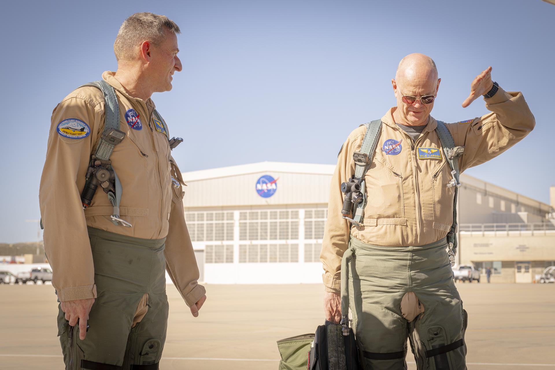
Two men, wearing tan flight suits and green flight gear, walk on a concrete surface away from a building in the background. The man on the left looks at the man on the right as he is moving his left hand in the air. This same man is carrying a bag with flight gear in his right hand.
NASA test pilots Jim Less, left, and Nils Larson walk away from a hangar at NASA’s Armstrong Flight Research Center in Edwards, California, on Thursday, Feb. 4, 2026. The pilots support the agency’s Crossflow Attenuated Natural Laminar Flow (CATNLF) project, which aims to lower fuel costs for future commercial aircraft by testing a scale-model wing designed to improve laminar flow.
NASA/Christopher LC Clark

Every NASA test flight — whether it’s studying new software, hardware, or the revolutionary technology of an experimental X-plane — relies on engineers, researchers, pilots, maintenance crew, control room operators, and many others working together.

“Experienced operators and engineers evaluate how things work in flight,” Ringelberg said. “Most new technologies are designed to work in a lab or can be tested in a wind tunnel or other facility, but you never really know how they’ll perform until you fly them.”

Preflight tests often include computer analysis, simulation, wind tunnel testing, and ground tests focused on an aircraft’s ability to withstand the forces of flight and the environments through which it may fly. After hardware or software is deemed safe to fly, researchers turn the mission over to the flight test team.

To support testing, NASA Armstrong maintains an aircraft fleet modified to create space for new hardware or instruments, as well as the ability to integrate new software. These aircraft are flying laboratories, and pilots are trained to accomplish experimental missions.

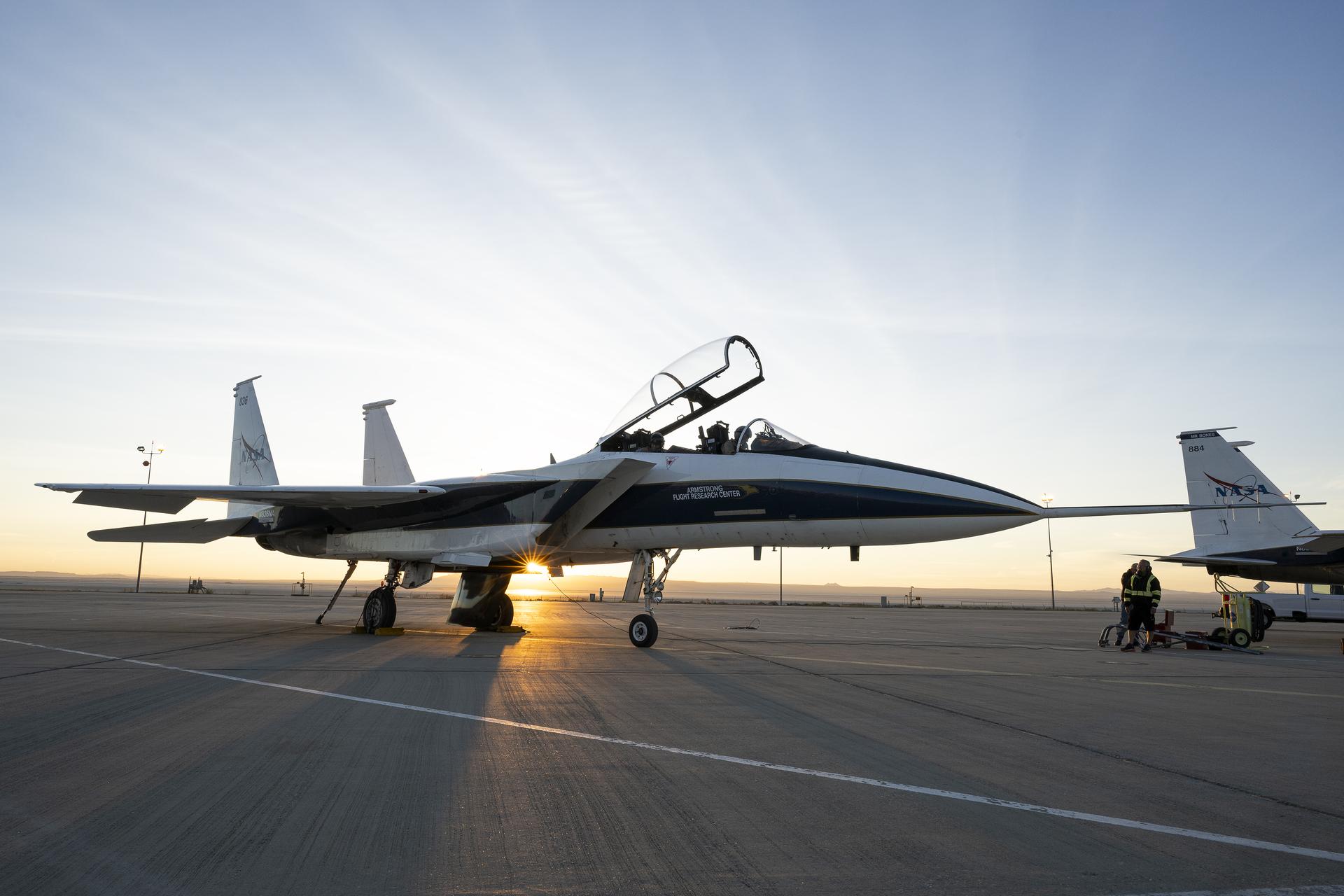
A white and blue painted jet aircraft sits on a concrete surface. The canopy of the aircraft is open, and two pilots sit inside wearing flight gear. The tail of a second jet aircraft is seen to the right of the image, and a desert landscape is seen in the background.
An F-15 research aircraft sits on the ramp at NASA’s Armstrong Flight Research Center in Edwards, California, on Tuesday, March 17, 2026. NASA pilots Jim Less, front seat, and Carrie Worth prepare for the flight. The agency’s Crossflow Attenuated Natural Laminar Flow (CATNLF) test article is attached to the bottom of the F-15. The project aims to lower fuel costs for future commercial aircraft by testing a scale-model wing designed to improve laminar flow.
NASA/Carla Escamilla

For example, flight testing recently helped NASA gather critical data on laminar flow, or the smooth flow of air, over a wing. The work could lower fuel costs for future airliners. Computer modeling, wind tunnel tests, and other methods helped advance the research, but to find out even more about how the wing concept could reduce drag for future airliners, NASA used a scale model in actual flight.

NASA researchers strapped the Crossflow Attenuated Natural Laminar Flow (CATNLF) model wing to the belly of one of NASA Armstrong’s F-15s. The arrangement allowed them to collect all the information they would need without doing the extensive, costly modifications required to install a full-scale wing on an aircraft.

After a flight series is complete, engineers and researchers analyze the data. Did the instrument work as designed? Did the experimental aircraft perform safely at a high altitude? Did the software operate as planned? Each test raises its own set of questions to evaluate.

NASA continues working with academia, the Department of War, and industry partners to advance U.S. aviation through flight test and bring new benefits to the flying public.

Share

Details

Last Updated
Jun 22, 2026
Editor
Dede Dinius
Contact
Keep Exploring

Discover More Topics From NASA

💾

NASA’s Crossflow Attenuated Natural Laminar Flow (CATNLF) project aims to lower fuel costs for future commercial aircraft by testing a scale-model wing desig...

NASA Flights Map Tropical Ecosystems, Water, Ice

15 June 2026 at 20:24

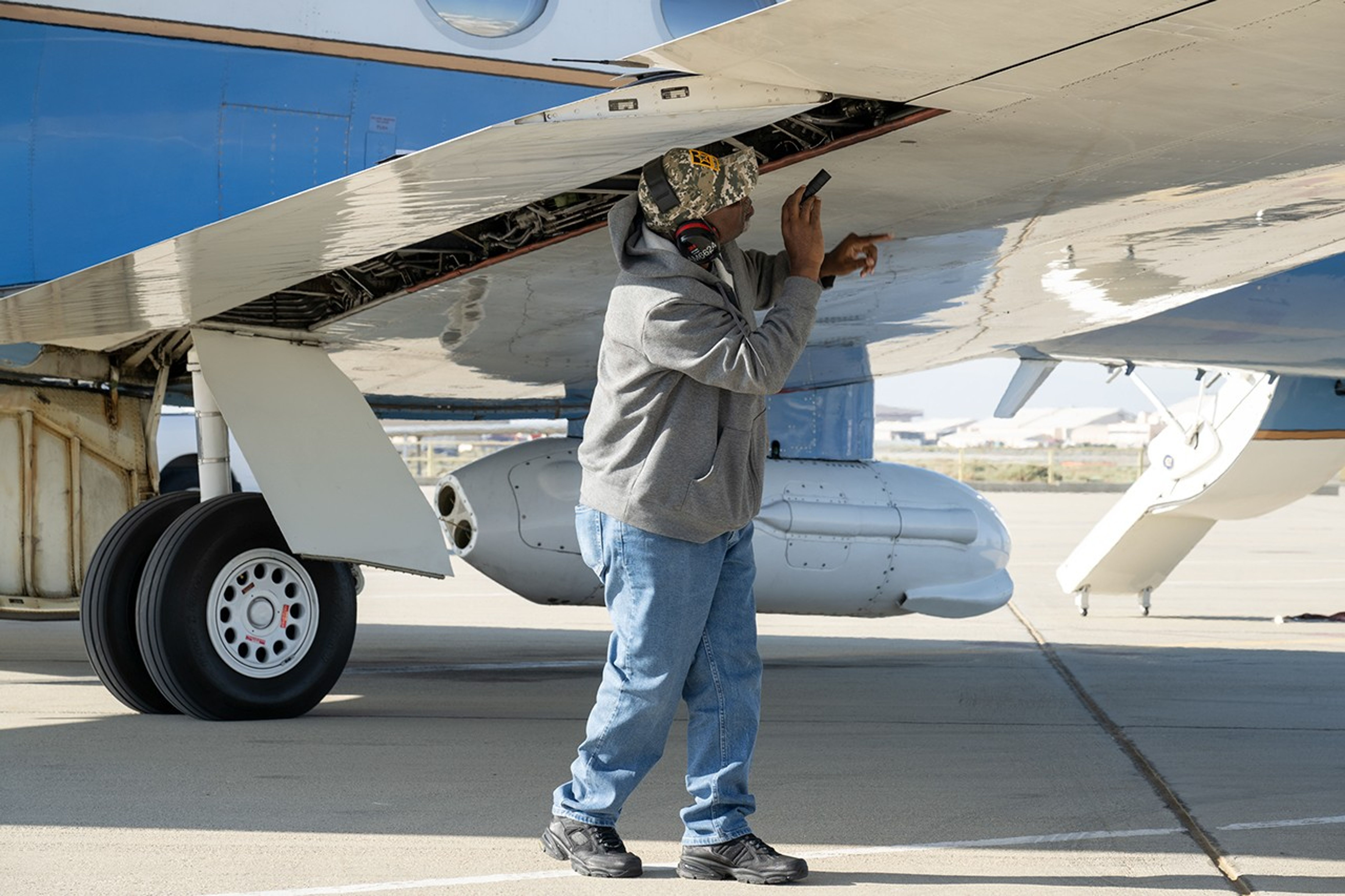
A man uses a flashlight to inspect an aircraft’s wing as part of the preflight checks.
Alvin Mitchell, a NASA C-20A aircraft quality assurance inspector, completes preflight checks at NASA’s Armstrong Flight Research Center in Edwards, California, on April 29 for a mission over Central California. On May 2, the aircraft departed for the Tropical Synthetic Aperture Radar campaign carrying NASA’s Uninhabited Aerial Vehicle Synthetic Aperture Radar.
NASA/Ryan Kline

Data from a NASA campaign in Panama and Peru will help communities prepare for tropical floods in cloud-covered areas, improve scientific understanding of forest health, and support planning for spaceborne missions.

NASA’s C-20A aircraft from Armstrong Flight Research Center in Edwards, California, flew the Uninhabited Aerial Vehicle Synthetic Aperture Radar (UAVSAR) instrument, developed at NASA’s Jet Propulsion Laboratory in Southern California, to gather mission data. While flying repeat paths, the instrument collected high-resolution radar data from a pod mounted beneath the aircraft. The monthlong campaign, known as Tropical Synthetic Aperture Radar, or TropiSAR, concluded on June 4 after 17 flights totaling 75 hours.

Airborne data were captured over Peru in the same times and locations as data captured by the NISAR (NASA-ISRO Synthetic Aperture Radar) satellite to validate key NISAR capabilities and support calibration of the satellite’s L-band radar system. The science validation targeted two measurements: tropical rainforest flood extent within the Pacaya-Samiria National Reserve in Peru, one of the world’s largest protected flooded forests, and glacier movement in the Huascarán National Park in the Peruvian Andes, which is home to the largest concentration of tropical glaciers. The mission also gathered detailed 3D views of tree height and density to estimate biomass, assess forest health, and better understand how forest ecosystems store and release carbon.

In Panama, TropiSAR also supported NASA’s Airborne Validation Unified Experiment: Land and Ocean (AVUELO) campaign in collaboration with the Smithsonian Tropical Research Institute. Airborne radar data were collected from dry forests and coastal wetlands with the goal of better understanding Panama’s rich biodiversity. By linking field measurements with airborne and satellite observations, AVUELO may advance new methods for studying the tropics.

~Jay Levine

The post NASA Flights Map Tropical Ecosystems, Water, Ice appeared first on NASA Science.

NASA’s X-59 Reaches Speed, Altitude for Future Quiet Supersonic Flights

12 June 2026 at 20:35
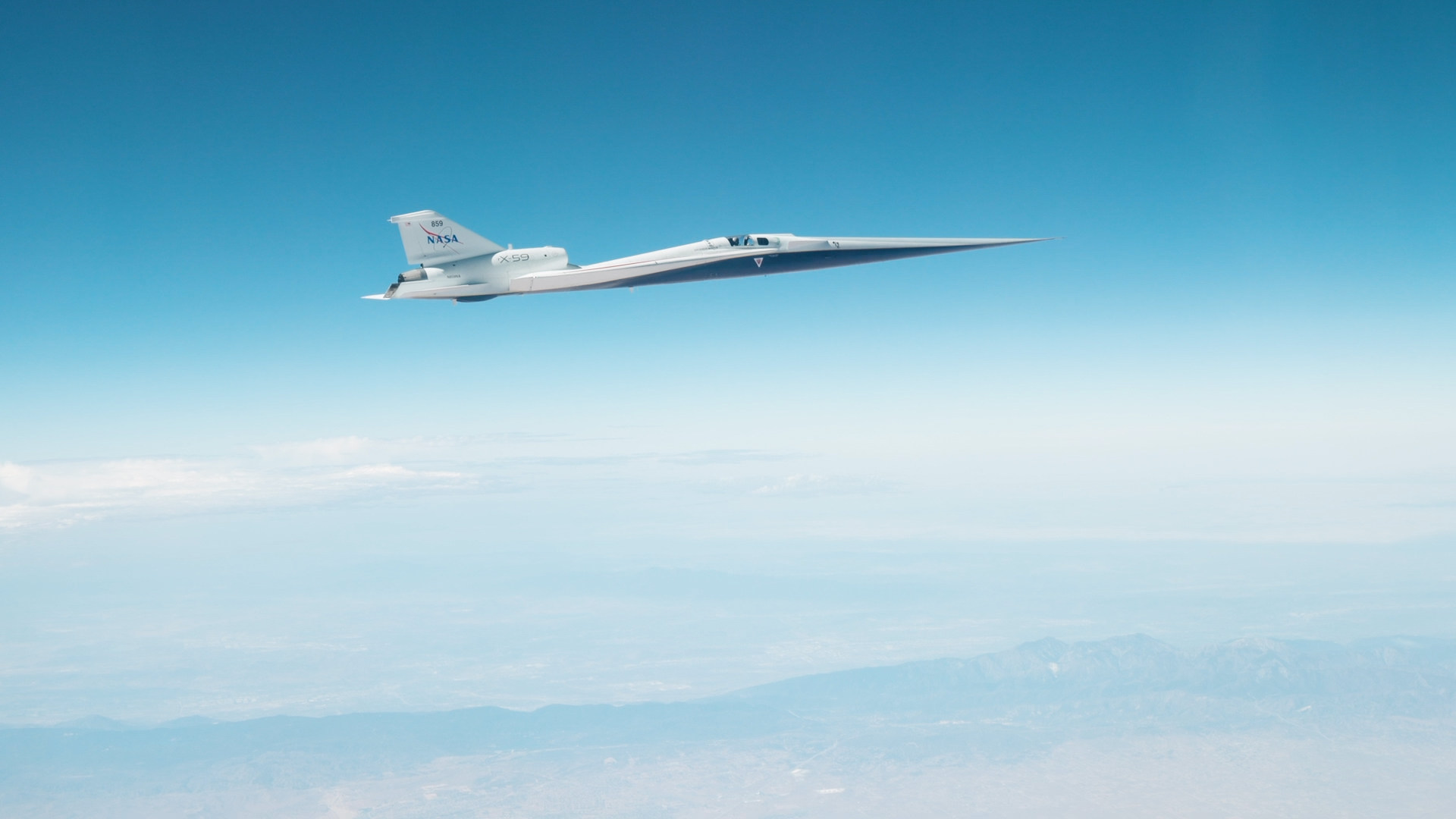
The X-59 in flight on June 12, 2026 against a blue sky.
NASA’s X-59 quiet supersonic research aircraft reached its target speed and altitude for future community overflights for the first time during a flight on Friday, June 12, 2026. The milestone marked the first time the aircraft flew at Mach 1.4 and 55,000 feet — conditions it will fly when gathering community response data to its quiet sonic thump.
NASA/Lori Losey

NASA’s X-59 experimental aircraft reached a major milestone Friday, June 12, flying Mach 1.4 (about 924 mph) and an altitude of 55,000 feet, the conditions required for the aircraft to make future flights critical to its mission.  

The X-59 still has months of performance testing ahead, but after those are complete, NASA’s Quesst mission will fly the aircraft over several U.S. communities to collect data on public perception of the quiet sonic thump it will make at supersonic speeds. Those community overflights will include flights at Mach 1.4 and 55,000 feet. 

The milestone comes just days after the X-59’s first supersonic flight. That flight showed the aircraft performed as expected at Mach 1.1, but Friday’s mission conditions flight was an even more critical step for NASA. 

The aircraft’s team has steadily expanded the aircraft’s flight envelope by evaluating its performance at a variety of speeds and altitudes, and having its pilots take on a battery of maneuvers.  

Photo of the XVS screen on the X-59 showing Mach 1.4 at 55,030 was achieved.
NASA’s X‑59 eXternal Vision System (XVS) shows Mach 1.4 at 55,030 feet on Friday, June 12, 2026 during the aircraft’s first mission conditions flight, the approximate conditions it will fly when gathering community response data to its quiet “sonic thump.” The milestone marks the first time the aircraft flew at its designed speed and altitude.
NASA/Lori Losey

The X-59 was designed to fly supersonic without causing a loud sonic boom. However, for these early supersonic flights it has been accompanied by a NASA F-15 research aircraft, a traditional supersonic jet that causes booms obscuring any noise the X-59 makes. During upcoming flights, a shock-sensing probe mounted to the F-15 will gather measurements of the X-59’s shock wave signature, an early measure of its supersonic performance. 

After the team conducts more tests at a variety of altitudes and conditions to complete envelope expansion, the X-59 will enter the acoustic validation phase of Quesst. During this phase, researchers will thoroughly measure the aircraft’s supersonic acoustic signature — the quiet thump it’s designed to make — to confirm it is performing as intended. 

Each flight brings NASA one step closer to flying the X-59 over communities and gathering feedback that could help shape the future of commercial supersonic flight over land. 

More X-59 to Explore

quesst-logo-horizontal-051826sm

Read more on the Quesst mission page.

The post NASA’s X-59 Reaches Speed, Altitude for Future Quiet Supersonic Flights appeared first on NASA Science.

Hazard Detection Lidar System Goes to the Moon

12 June 2026 at 18:41

Hazard Detection Lidar System Goes to the Moon

A flight testing success story

Enabling landers to autonomously identify the safest sites to touch down

Moon craters and their surrounding areas are high-value destinations for lunar missions since they may contain important resources and valuable science targets. However, these sites are also home to dangers such as steep slopes that are difficult to see in the challenging lighting conditions. As a result, selecting landing sites on lunar surfaces is a critical component for NASA’s CLPS (Commercial Lunar Payload Services) missions. A new technology tested through NASA’s Flight Opportunities program is set to go to the Moon and help provide a safe and precise landing.

Astrobotic Technology’s Hazard Detection (HD) Lidar system scans and analyzes the terrain in real-time, enabling landers to autonomously map and select the safest landing sites. Lidar stands for light detection and ranging. The Pittsburgh-headquartered company will use its HD Lidar system when its Griffin lunar lander delivers science and technology payloads to the Moon during its CLPS delivery to the lunar south pole.

With Flight Opportunities support, Astrobotic first tested an engineering model of its advanced HD Lidar sensor in November 2024, confirming its ability to select a safe landing site by detecting and avoiding slopes, rough areas, and potential hazards. This flight test provided the Astrobotic team valuable data on the system’s performance, which was later leveraged by a second flight test in March 2026 with an integrated hazard detection and guidance, navigation, and control (GNC) system to further validate the system ahead of its first lunar mission scheduled for later this year. These flight tests helped the company advance the technology for use on its CLPS mission.

Preparing for Griffin Mission One | Flight testing lidar hazard detection video | Additional information

Preparing for Griffin Mission One

The Astrobotic Griffin Mission One will launch aboard a SpaceX Falcon Heavy rocket from Launch Complex 39A at NASA’s Kennedy Space Center in Florida to deliver NASA payloads to the lunar south pole.

Astrobotic’s HD Lidar system is designed to detect hazards as small as 5.9 inches (15 cm) and slopes greater than 10° to identify potential hazards, such as craters or large rocks. During the lander’s final descent phase, the spacecraft performs a stationary hover at an altitude of 100 meters — about the height of a 30-story building — while pointing its lidar toward the intended landing site. During the hover, the lidar scans the terrain, applies motion correction to account for changes in the spacecraft’s position and attitude, and processes the results into a hazard map used to identify the safest available landing location. The spacecraft then maneuvers to the selected landing site and proceeds with touchdown.
 
Astrobotic’s HD Lidar system works in tandem with its terrain relative navigation (TRN) sensor system, which takes live photos of the surface and compares them to an onboard map derived from orbital images to determine the spacecraft’s location above the lunar surface. In preparation for the CLPS mission, Astrobotic fully integrated its HD Lidar and TRN camera into its Griffin lander and demonstrated a successful soft landing simulation using Astrobotic’s Griffin Mission One production flatsat — a platform built with engineering models of the actual flight avionics.

Learn more about the Griffin Mission One CLPS delivery about Preparing for Griffin Mission One
Astrobotic’s Griffin-1 lunar lander on a raised platform inside a spacecraft integration facility beneath a large Astrobotic logo mounted on the wall.
Astrobotic’s Griffin lunar lander inside the company’s integration facility. The lander uses Hazard Detection Lidar technology tested with support of NASA’s Flight Opportunities program.
Astrobotic

Advancing Hazard Detection Lidar Through Flight Testing

NASA’s Flight Opportunities program supported testing of Astrobotic’s HD Lidar as part of its mission to demonstrate promising technologies for space exploration, scientific discovery, and the expansion of space commerce. During the flight test on Nov. 11, 2024, an engineering model of the HD Lidar sensor successfully collected data over Astrobotic’s Lunar Surface Proving Ground while mounted on the company’s Xodiac reusable vertical takeoff vertical landing rocket. During the flight, the HD Lidar system processed the 3D lidar point cloud data into a terrain hazard map and helped verify lidar communications, settings, and controls under relevant conditions.

This flight test enabled Astrobotic to make a significant advancement in demonstrating space exploration technology capabilities, and the company applied lessons from this test directly to its lunar lander missions.

Learn more about the HD Lidar 2024 flight test

Additional Information

CLPS Flight: Astrobotic Griffin-1

Moon Missions for Flight-Tested Doppler Lidar

Moon - North Polar Mosaic, Color

Commercial Lunar Payload Services Blog

Challenger Astronauts Memorialized on the Moon

NASA Tests New Ways to Stick the Landing in Challenging Terrain

Flight test planning using simulated scans from Xodiac historical flight data and Lidar Hazard Detection scan settings in simulation.
Astrobotic
The Hazard Detection Lidar payload, as integrated on the top of Xodiac. The lidar is the box on the left pointed down towards the ground; This pointing angle enables it to view the surface of the Lunar Surface Proving Ground during the flight test.
Astrobotic
Astrobotic’s Griffin-1 lunar lander inside a spacecraft integration facility.
Astrobotic’s Griffin lunar lander is seen inside the company’s integration facility.
Astrobotic

Learn More About Flight Opportunities

Earthrise as seen from lunar orbit

More Technology Transitions

Learn about other technologies that have advanced their readiness through testing with Flight Opportunities.

World View’s Stratollite high-altitude balloon is inflated on the launch pad.

Access Flight Testing

Learn more about how to flight test your technology, instrument, or experiment with the Flight Opportunities program.

Engineer testing the suborbital rocket.

Flight Providers

Learn about the commercial flight providers that engage with the Flight Opportunities program.

The post Hazard Detection Lidar System Goes to the Moon appeared first on NASA Science.

NASA, USGS Scientists Go Rock Hounding in California’s High Desert

11 June 2026 at 16:38
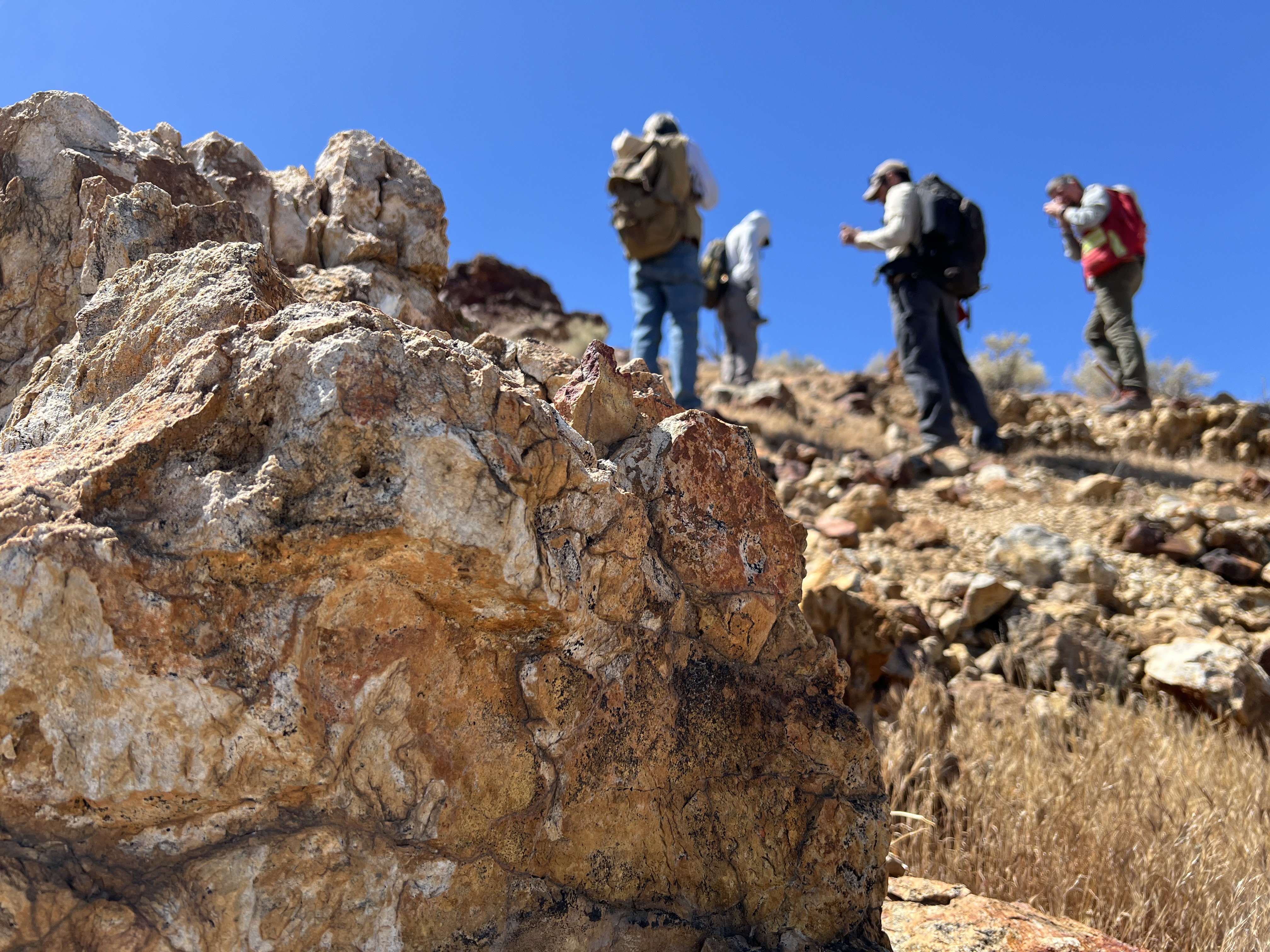
Four people with backpacks pause to examine rocks on a hillside under a clear blue sky, with a large orange-and-tan boulder in the foreground.
Geologists recently converged on a site near Barstow, California, to ground-truth a mineral discovery made on public land by a NASA JPL sensor flying aboard a plane overhead.
NASA/JPL-Caltech

Equipped with rock picks and hand lenses, a team of geoscientists deployed to the Mojave Desert recently to investigate a tantalizing “fingerprint” detected by a NASA sensor. Their target: a cache of topaz hiding in plain sight.

The geologists weren’t searching for gem-grade treasure. Rather, the presence of topaz could hint at a more valuable deposit below of something known as porphyry copper.

One of the world’s primary sources of copper, these deposits are left behind when magma and hot water from deep underground course through Earth’s crust, chemically transforming the surrounding rock. This tends to occur where one tectonic plate dives below another, known as a subduction zone, such as the North American Cordillera, which stretches from the Canadian Rockies to western Mexico.

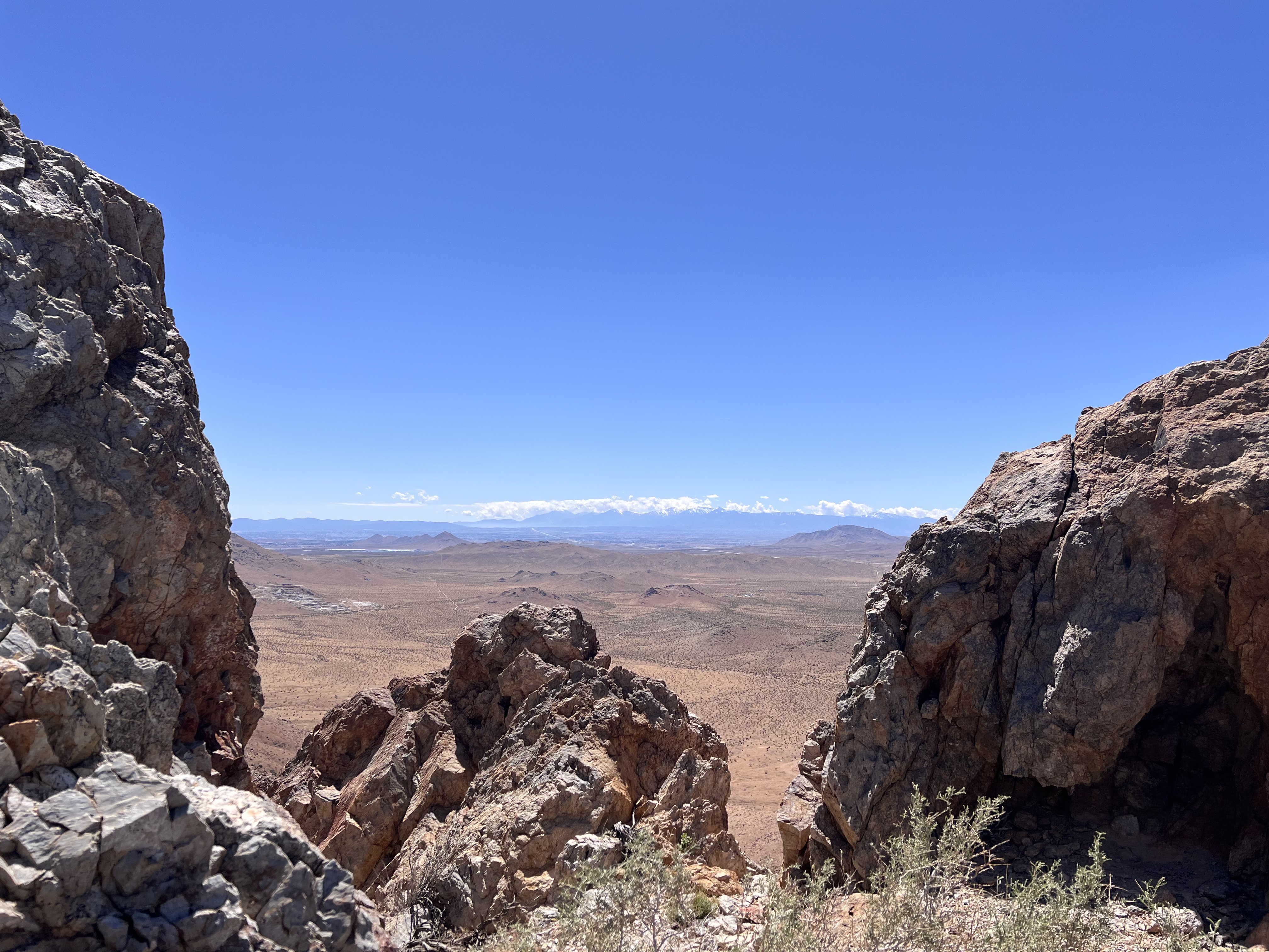
A wide-angle shot framing a vast desert plain viewed through a natural gap between jagged rock formations in the foreground. Distant snowcapped hills stretch across the far horizon beneath a thin line of cloud.
California’s high desert stretches below a bright spring sky in April 2026. NASA and USGS scientists are using airborne remote sensing to home in on potential sources of critical minerals here and across the Western U.S.
NASA/JPL-Caltech

In addition to copper — the third most used metal in the world after steel and aluminum — the deposits can hold other critical minerals like molybdenum and tellurium, which are used in everything from steelmaking to solar panels. Finding the deposits isn’t easy. Geologists look for topaz because it forms under the same volcanic conditions.

For the team in the Mojave, the goal was to collect more evidence. That would require boots on the ground and a heavy bag of samples. The scientists who converged on the site included three experts from the U.S. Geological Survey (USGS) and Robert Green of NASA’s Jet Propulsion Laboratory in Southern California.

“What we’re doing out here is geologic CSI,” said Green, referring to the investigative TV show, as he split open a weathered red rock to expose a sparkling core. “We’re looking for clues to reconstruct what happened here.”

A three-dimensional cube representing multispectral imaging data of an arid landscape. The front face shows an aerial image. The top and side panels display colored bands ranging from blue to red, illustrating spectral information for each pixel.
Three-dimensional image cubes illustrate the volume of data captured by NASA imaging spectrometers. The front face shows an aerial view of the Mojave Desert. The colorful side panels reveal what no eye or camera can detect: the spectral fingerprints of minerals present in every pixel.
NASA/JPL-Caltech

Next-generation mineral mapping

The sensor that detected the topaz deposit on public land near Barstow, California, was built at JPL. Called AVIRIS, short for Airborne Visible Infrared Imaging Spectrometer, it analyzes reflected sunlight and can be used to identify chemicals and minerals by their unique spectral fingerprint. The technology was pioneered in the early 1980s by a team that included Green, and space-hardened versions have explored the Moon, Mars, and other rocky bodies in the solar system in the decades since.

While its cousins study distant worlds aboard spacecraft, the AVIRIS line of sensors is advancing Earth science from aircraft. The latest model, AVIRIS-5, recently took to the skies for the first time as part of the NASA-USGS Geologic Earth Mapping Experiment (GEMx). The goal of GEMx is to identify sources of critical minerals across the American West, including in the waste rock of active and legacy mines. It is led by the USGS as part of its larger, nationwide initiative.

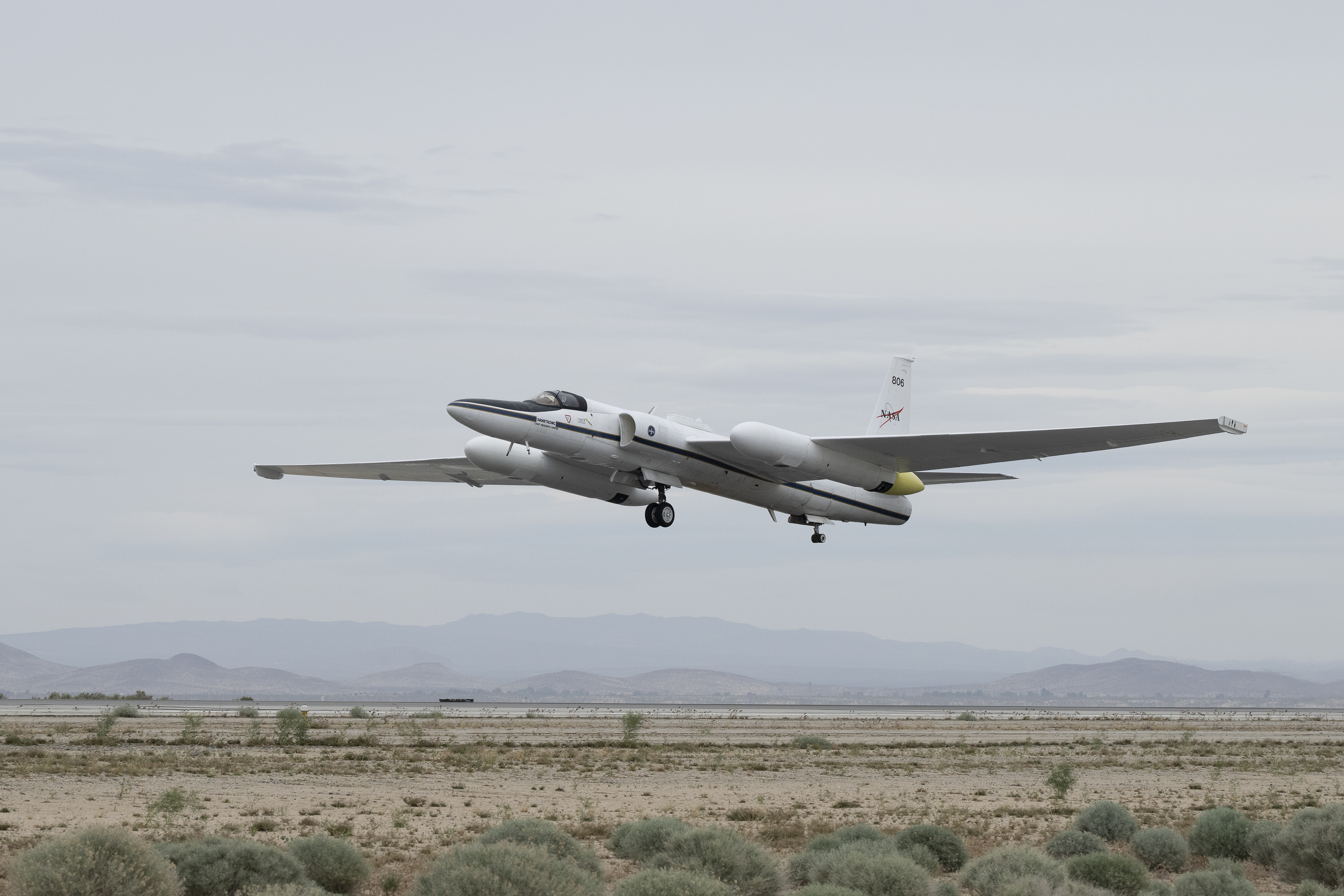
Carrying next-generation sensors, a high-altitude NASA ER-2 aircraft takes off from the agency’s Armstrong Flight Research Center in Edwards, California, on March 31, 2026, to support the GEMx mineral mapping campaign.
NASA/Carla Thomas

Since 2023, GEMx flights have covered more than 386,000 square miles (1 million square kilometers) of American soil, including most of California.

Ground-truthing the sensor data can entail hot field work, scrambling over steep crags to uncover samples for lab analysis. While testing has confirmed the topaz discovery, determining if the Mojave site overlies a porphyry copper deposit will require intensive investigation using ground-penetrating equipment. But the AVIRIS finding shows how advanced NASA airborne sensing can help lead geologists to the metaphorical needle in a haystack, even in heavily explored Southern California.

“People have been prospecting this area for generations,” said Erik Tharalson, a USGS geologist. “But there’s a lot more to discover.”

High flyer

From the beginning, the GEMx mineral mapping campaign has been enabled by one of the highest-flying aircraft in NASA’s fleet: the ER‑2. It deployed on March 31 from NASA’s Armstrong Flight Research Center in Edwards, California, to Colorado Springs Airport in Colorado.

“We deployed to Colorado Springs to maximize flight time for data collection needed in Colorado, Utah, New Mexico, Arizona, and Texas,” said John McGrath, ER‑2 project manager at NASA Armstrong.

By the conclusion of this deployment on June 5, the aircraft had completed 26 flights totaling more than 125 hours. Soaring at about 65,000 feet, the ER-2 can fly at high altitudes that allow it to collect broad‑area, high‑resolution spectral measurements in a single pass, supporting researchers studying mineral composition and surface processes.

In 2025, the aircraft flew 36 science missions, collecting more than 7 billion measurements over 200 flight hours. The data has contributed to the largest airborne surface mineralogy dataset gathered in a single NASA-USGS campaign.

The GEMx survey is led and funded by the USGS Earth Mapping Resources Initiative. Earth MRI is modernizing mapping the nation’s surface and subsurface to find new, critical, and other minerals. It is a partnership effort with 45 state geological surveys, federal agencies, private industry, tribes, universities, and others. The initiative will capitalize on both the technology developed by NASA for spectroscopic imaging, as well as the USGS expertise in analyzing the datasets, conducting field work, and deriving critical mineral information from them.

To learn more about GEMx visit:

https://science.nasa.gov/mission/gemx/

Media Contacts

Andrew Wang / Andrew Good
Jet Propulsion Laboratory, Pasadena, Calif.
626-379-6874 / 818-393-2433
andrew.wang@jpl.nasa.gov / andrew.c.good@jpl.nasa.gov

Written by Sally Younger

2026-037

The post NASA, USGS Scientists Go Rock Hounding in California’s High Desert appeared first on NASA Science.
NASA, USGS Scientists Go Rock Hounding in California’s High Desert

11 June 2026 at 16:38
Four people with backpacks pause to examine rocks on a hillside under a clear blue sky, with a large orange-and-tan boulder in the foreground.
Geologists recently converged on a site near Barstow, California, to ground-truth a mineral discovery made on public land by a NASA JPL sensor flying aboard a plane overhead.
NASA/JPL-Caltech

Equipped with rock picks and hand lenses, a team of geoscientists deployed to the Mojave Desert recently to investigate a tantalizing “fingerprint” detected by a NASA sensor. Their target: a cache of topaz hiding in plain sight.

The geologists weren’t searching for gem-grade treasure. Rather, the presence of topaz could hint at a more valuable deposit below of something known as porphyry copper.

One of the world’s primary sources of copper, these deposits are left behind when magma and hot water from deep underground course through Earth’s crust, chemically transforming the surrounding rock. This tends to occur where one tectonic plate dives below another, known as a subduction zone, such as the North American Cordillera, which stretches from the Canadian Rockies to western Mexico.

A wide-angle shot framing a vast desert plain viewed through a natural gap between jagged rock formations in the foreground. Distant snowcapped hills stretch across the far horizon beneath a thin line of cloud.
California’s high desert stretches below a bright spring sky in April 2026. NASA and USGS scientists are using airborne remote sensing to home in on potential sources of critical minerals here and across the Western U.S.
NASA/JPL-Caltech

In addition to copper — the third most used metal in the world after steel and aluminum — the deposits can hold other critical minerals like molybdenum and tellurium, which are used in everything from steelmaking to solar panels. Finding the deposits isn’t easy. Geologists look for topaz because it forms under the same volcanic conditions.

For the team in the Mojave, the goal was to collect more evidence. That would require boots on the ground and a heavy bag of samples. The scientists who converged on the site included three experts from the U.S. Geological Survey (USGS) and Robert Green of NASA’s Jet Propulsion Laboratory in Southern California.

“What we’re doing out here is geologic CSI,” said Green, referring to the investigative TV show, as he split open a weathered red rock to expose a sparkling core. “We’re looking for clues to reconstruct what happened here.”

A three-dimensional cube representing multispectral imaging data of an arid landscape. The front face shows an aerial image. The top and side panels display colored bands ranging from blue to red, illustrating spectral information for each pixel.
Three-dimensional image cubes illustrate the volume of data captured by NASA imaging spectrometers. The front face shows an aerial view of the Mojave Desert. The colorful side panels reveal what no eye or camera can detect: the spectral fingerprints of minerals present in every pixel.
NASA/JPL-Caltech

Next-generation mineral mapping

The sensor that detected the topaz deposit on public land near Barstow, California, was built at JPL. Called AVIRIS, short for Airborne Visible Infrared Imaging Spectrometer, it analyzes reflected sunlight and can be used to identify chemicals and minerals by their unique spectral fingerprint. The technology was pioneered in the early 1980s by a team that included Green, and space-hardened versions have explored the Moon, Mars, and other rocky bodies in the solar system in the decades since.

While its cousins study distant worlds aboard spacecraft, the AVIRIS line of sensors is advancing Earth science from aircraft. The latest model, AVIRIS-5, recently took to the skies for the first time as part of the NASA-USGS Geologic Earth Mapping Experiment (GEMx). The goal of GEMx is to identify sources of critical minerals across the American West, including in the waste rock of active and legacy mines. It is led by the USGS as part of its larger, nationwide initiative.

Carrying next-generation sensors, a high-altitude NASA ER-2 aircraft takes off from the agency’s Armstrong Flight Research Center in Edwards, California, on March 31, 2026, to support the GEMx mineral mapping campaign.
NASA/Carla Thomas

Since 2023, GEMx flights have covered more than 386,000 square miles (1 million square kilometers) of American soil, including most of California.

Ground-truthing the sensor data can entail hot field work, scrambling over steep crags to uncover samples for lab analysis. While testing has confirmed the topaz discovery, determining if the Mojave site overlies a porphyry copper deposit will require intensive investigation using ground-penetrating equipment. But the AVIRIS finding shows how advanced NASA airborne sensing can help lead geologists to the metaphorical needle in a haystack, even in heavily explored Southern California.

“People have been prospecting this area for generations,” said Erik Tharalson, a USGS geologist. “But there’s a lot more to discover.”

High flyer

From the beginning, the GEMx mineral mapping campaign has been enabled by one of the highest-flying aircraft in NASA’s fleet: the ER‑2. It deployed on March 31 from NASA’s Armstrong Flight Research Center in Edwards, California, to Colorado Springs Airport in Colorado.

“We deployed to Colorado Springs to maximize flight time for data collection needed in Colorado, Utah, New Mexico, Arizona, and Texas,” said John McGrath, ER‑2 project manager at NASA Armstrong.

By the conclusion of this deployment on June 5, the aircraft had completed 26 flights totaling more than 125 hours. Soaring at about 65,000 feet, the ER-2 can fly at high altitudes that allow it to collect broad‑area, high‑resolution spectral measurements in a single pass, supporting researchers studying mineral composition and surface processes.

In 2025, the aircraft flew 36 science missions, collecting more than 7 billion measurements over 200 flight hours. The data has contributed to the largest airborne surface mineralogy dataset gathered in a single NASA-USGS campaign.

The GEMx survey is led and funded by the USGS Earth Mapping Resources Initiative. Earth MRI is modernizing mapping the nation’s surface and subsurface to find new, critical, and other minerals. It is a partnership effort with 45 state geological surveys, federal agencies, private industry, tribes, universities, and others. The initiative will capitalize on both the technology developed by NASA for spectroscopic imaging, as well as the USGS expertise in analyzing the datasets, conducting field work, and deriving critical mineral information from them.

To learn more about GEMx visit:

https://science.nasa.gov/mission/gemx/

Media Contacts

Andrew Wang / Andrew Good
Jet Propulsion Laboratory, Pasadena, Calif.
626-379-6874 / 818-393-2433
andrew.wang@jpl.nasa.gov / andrew.c.good@jpl.nasa.gov

Written by Sally Younger

2026-037

NASA Awards Contract for Construction Services in California

10 June 2026 at 21:32
NASA insignia.
Credit: NASA

NASA has selected multiple small businesses for the Western Regional Multiple Award Construction Contract, which supports a broad range of facility enhancement, modernization, and sustainment work at NASA’s Armstrong Flight Research Center in Edwards, California, NASA’s Ames Research Center in California’s Silicon Valley, and other federal agencies in the region.

The contract provides general construction, modification, maintenance and repair, and demolition services, as well as new construction of buildings and facilities that incorporate Leadership in Energy and Environmental Design practices and building information modeling to support efficient and sustainable project execution.

The indefinite-delivery/indefinite-quantity, firm-fixed-price contract is a follow-on to the agency’s previous regional construction contract and has a potential value of $450 million over a five‑year period.

Contract awardees are:

  • Abide International Inc.
  • Able Heating and Air Conditioning
  • Anderson Burton Construction Inc.
  • Anna Lisa Luna Construction
  • Barkley Andross Corporation
  • Bibro Construction Company Inc.
  • CM Construction Services
  • CMS Construction Inc.
  • FASONE
  • G‑1 Lead Builders JV LLC
  • Gideon USA
  • Good‑men Roofing & Construction Inc.
  • Groundlevel Construction Inc.
  • IPI Construction Inc.
  • Innovative Project Solutions Inc.
  • Ironwood Commercial Builders Inc.
  • J.I. Garcia Construction Inc.
  • JG Contracting
  • Lead Builders Inc.
  • Martinez Construction Services
  • MX Construction Inc.
  • OCS Construction Services Inc.
  • Patricia I. Romero Inc., doing business as Pacific West Builders
  • Gustav Keoni, doing business as Precision Construction
  • Prime MIK JV LLC
  • Spectrum Builders and Renovations Inc.
  • Sea Pac Engineering Inc.
  • Sergent Construction
  • Souza Construction Inc.
  • TLI Construction Inc.

For more information about NASA and agency programs, visit:

https://www.nasa.gov

-end-

Jennifer Dooren / Jessica Taveau
Headquarters, Washington
202-358-1600
jennifer.m.dooren@nasa.gov / jessica.c.taveau@nasa.gov

Dede Dinius
Armstrong Flight Research Center, Edwards, Calif.
661-276-5701
darin.l.dinius@nasa.gov

Share

Details

Last Updated
Jun 10, 2026
Editor
Jessica Taveau

The post NASA Awards Contract for Construction Services in California appeared first on NASA Science.
NASA Awards Contract for Construction Services in California

10 June 2026 at 21:32
NASA insignia.
Credit: NASA

NASA has selected multiple small businesses for the Western Regional Multiple Award Construction Contract, which supports a broad range of facility enhancement, modernization, and sustainment work at NASA’s Armstrong Flight Research Center in Edwards, California, NASA’s Ames Research Center in California’s Silicon Valley, and other federal agencies in the region.

The contract provides general construction, modification, maintenance and repair, and demolition services, as well as new construction of buildings and facilities that incorporate Leadership in Energy and Environmental Design practices and building information modeling to support efficient and sustainable project execution.

The indefinite-delivery/indefinite-quantity, firm-fixed-price contract is a follow-on to the agency’s previous regional construction contract and has a potential value of $450 million over a five‑year period.

Contract awardees are:

  • Abide International Inc.
  • Able Heating and Air Conditioning
  • Anderson Burton Construction Inc.
  • Anna Lisa Luna Construction
  • Barkley Andross Corporation
  • Bibro Construction Company Inc.
  • CM Construction Services
  • CMS Construction Inc.
  • FASONE
  • G‑1 Lead Builders JV LLC
  • Gideon USA
  • Good‑men Roofing & Construction Inc.
  • Groundlevel Construction Inc.
  • IPI Construction Inc.
  • Innovative Project Solutions Inc.
  • Ironwood Commercial Builders Inc.
  • J.I. Garcia Construction Inc.
  • JG Contracting
  • Lead Builders Inc.
  • Martinez Construction Services
  • MX Construction Inc.
  • OCS Construction Services Inc.
  • Patricia I. Romero Inc., doing business as Pacific West Builders
  • Gustav Keoni, doing business as Precision Construction
  • Prime MIK JV LLC
  • Spectrum Builders and Renovations Inc.
  • Sea Pac Engineering Inc.
  • Sergent Construction
  • Souza Construction Inc.
  • TLI Construction Inc.

For more information about NASA and agency programs, visit:

https://www.nasa.gov

-end-

Jennifer Dooren / Jessica Taveau
Headquarters, Washington
202-358-1600
jennifer.m.dooren@nasa.gov / jessica.c.taveau@nasa.gov

Dede Dinius
Armstrong Flight Research Center, Edwards, Calif.
661-276-5701
darin.l.dinius@nasa.gov

Share

Details

Last Updated
Jun 10, 2026
Editor
Jessica Taveau

NASA’s X-59 Flies Supersonic for First Time 

9 June 2026 at 00:17

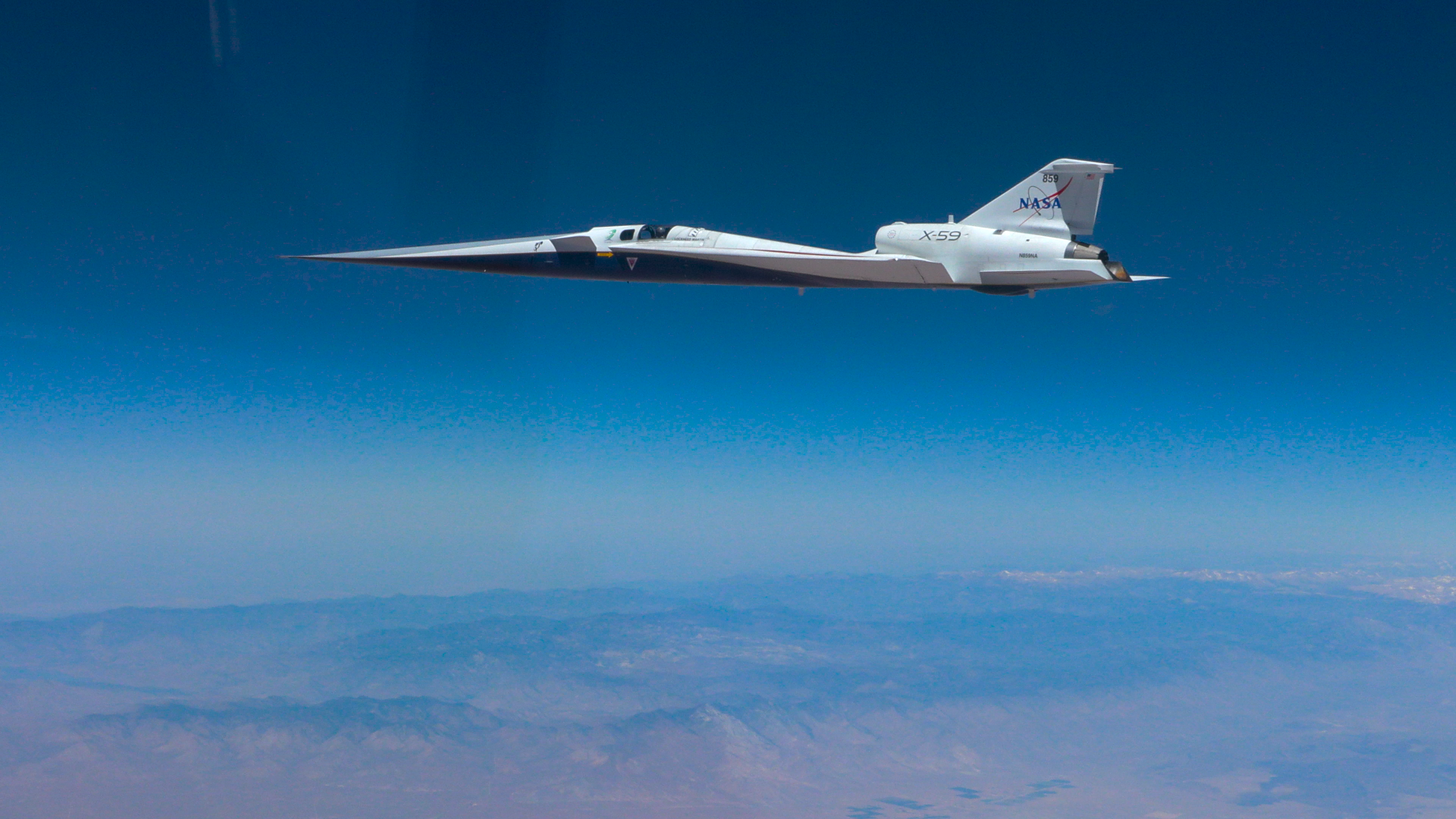
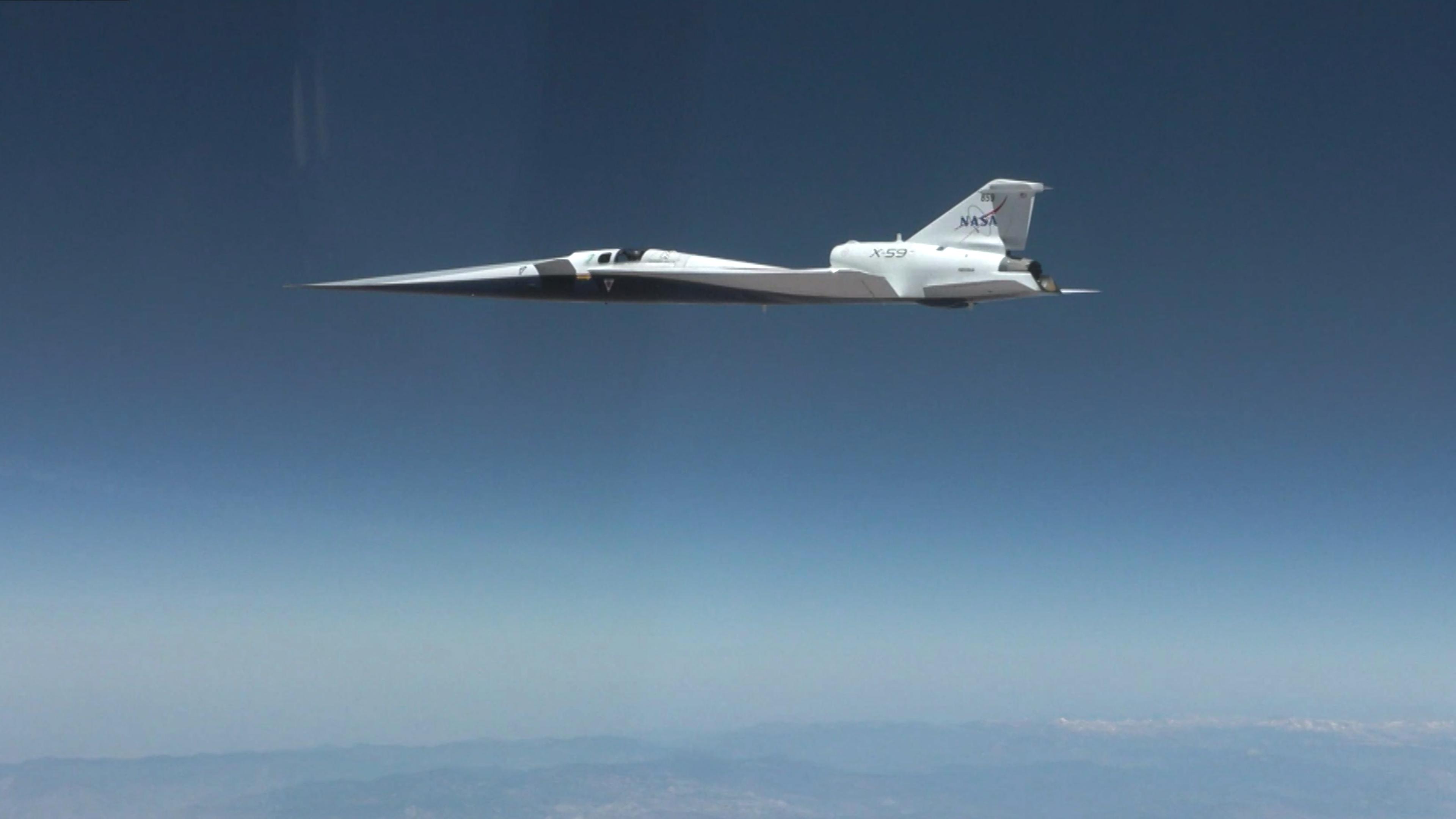
NASA’s X-59 quiet supersonic research aircraft flies above the clouds during its first supersonic flight. The aircraft is shown in side profile during level flight with desert and mountain terrain visible below.
NASA’s X-59 quiet supersonic research aircraft completed its first supersonic flight Friday, June 5, 2026, marking the first time the aircraft exceeded the speed of sound in support of NASA’s Quesst mission. The milestone represents a major step in flight testing as the aircraft expands into the supersonic portion of its flight envelope.
NASA/Lori Losey

NASA’s X-59 experimental aircraft reached a major milestone Friday, June 5, when it flew faster than the speed of sound for the first time.  

The 81-minute flight achieved a speed of Mach 1.1 (approximately 713 mph) at an altitude of 43,400 feet, with the X-59 performing as expected. For NASA test pilot Jim “Clue” Less, the plane’s instruments were the only indication of flying supersonic — exactly what the team wanted. 

“You know you are supersonic when gauges say you are supersonic. I didn’t feel anything,” Less said. “It went smoothly, and we easily got to Mach 1.1.” 

The X-59 is designed to fly at supersonic speeds while creating only a quiet thump instead of a loud sonic boom. For this flight, a NASA F‑15 chase plane flew nearby to monitor the test. Its loud sonic booms obscured any sound made by the X-59. The X-59 will conduct flights focused on its sound profile during a later phase of testing. 

Now that the X-59 has officially kicked off supersonic flight tests, the next big step is its first mission conditions flight. During this test, the X-59 will fly at the same speed and altitude planned for future tests, where the aircraft will fly over several U.S. communities to gather data from people on the ground about its noise levels: Mach 1.4 (925 mph) at 55,000 feet.  

“The plane wants to go faster, and we are looking forward to that,” Less said. 

The X-59 is the centerpiece of NASA’s Quesst mission, which aims to demonstrate quieter supersonic flight and to help enable commercial supersonic flight over land.  

This flight was also the first time the X‑59 appeared in NASA’s flight tracker.

More X-59 to Explore

quesst-logo-horizontal-051826sm

Read more on the Quesst mission page.

The post NASA’s X-59 Flies Supersonic for First Time  appeared first on NASA Science.
NASA’s X-59 Aircraft Flies Supersonic for First Time

5 June 2026 at 21:44

4 min read

NASA’s X-59 Aircraft Flies Supersonic for First Time

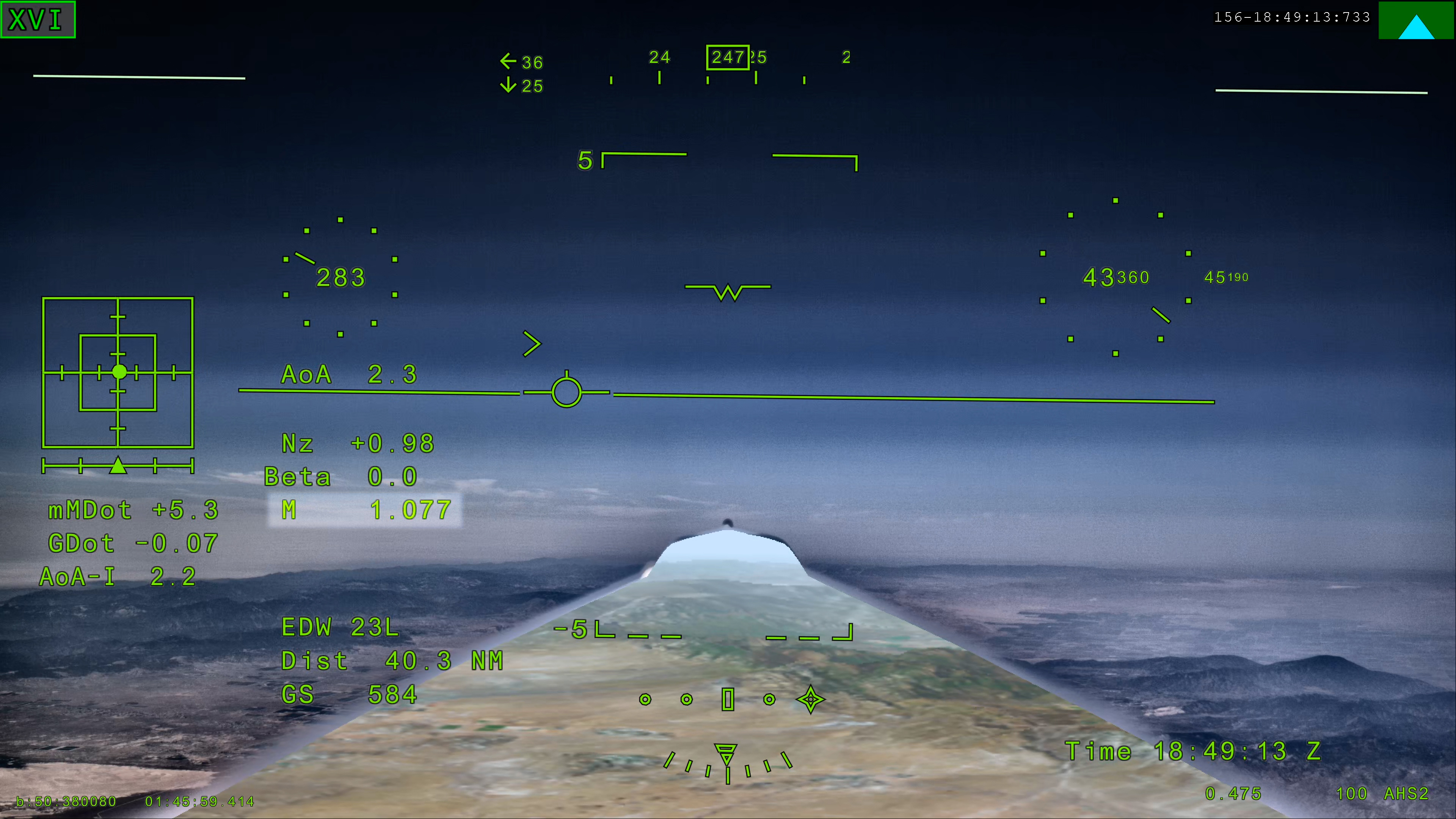
NASA’s X 59 eXternal Vision System digital display shows green flight data overlaid on the forward scenery as the aircraft flies supersonic. Numerical indicators, horizon references, and a Mach number readout are visible on the screen.
NASA’s X 59 eXternal Vision System shows Mach 1.077 on Friday, June 5, 2026, marking the aircraft’s first time reaching supersonic speed in support of NASA’s Quesst mission. The moment represents a milestone for the aircraft as it transitions to include test flights faster than the speed of sound.
NASA

NASA’s experimental X-59 aircraft marked a major milestone Friday, June 5, when it flew faster than the speed of sound for the first time, setting the stage for demonstrating its quiet supersonic capabilities later this year. 

NASA test pilot Jim “Clue” Less took off and landed at Edwards Air Force Base in California, reaching a top speed of approximately Mach 1.1 (713 mph) and altitude of 43,400 feet. The X-59’s flight began at 11:08 a.m. PDT and lasted 81 minutes, with the team focusing on flying qualities at both subsonic and then supersonic speeds.  

In the coming days, we expect to take the next step and push to Mach 1.4

jared isaacman

jared isaacman

NASA Administrator

”X-59 is getting ready for its quiet supersonic debut. Since the aircraft’s first flight on Oct. 28, 2025, the team has made tremendous progress, flying 16 times in the last 90 days and getting into a steady test rhythm. In the coming days, we expect to take the next step and push to Mach 1.4,” said NASA Administrator Jared Isaacman “I’m grateful to the NASA team and Lockheed Martin Skunk Works for their help getting us to this point, and I hope this is the first of many collaborations as we rebuild NASA’s X-plane portfolio.” 

The X-59 is designed to fly at supersonic speeds while creating only a quiet thump instead of a loud sonic boom. For this flight, a NASA F‑15 chase plane flew nearby to monitor the X‑59. The loud sonic booms from the F-15 obscured any sound made by the X-59.  

“The X-59’s first supersonic flight is a testament to America’s enduring leadership in science, engineering, and aerospace innovation,” said Michael Kratsios, Assistant to the President for Science and Technology and Director of the Office of Science and Technology Policy. “This achievement comes as the Trump Administration continues work to unleash supersonic flight and enable American ingenuity.” 

This first supersonic flight is a significant milestone, but an event even more critical to the mission is upcoming. In just days, the aircraft is expected to make its first “mission conditions” flight, reaching a cruising speed of Mach 1.4 (925 mph) and altitude of approximately 55,000 feet. The X-59 also will be accompanied by a chase plane for this flight.  

NASA’s X-59 quiet supersonic research aircraft flies above the clouds during its first supersonic flight. The aircraft is shown in side profile during level flight with desert and mountain terrain visible below.
NASA’s X-59 quiet supersonic research aircraft completed its first supersonic flight Friday, June 5, 2026, marking the first time the aircraft exceeded the speed of sound in support of NASA’s Quesst mission. The milestone represents a major step in flight testing as the aircraft expands into the supersonic portion of its flight envelope.
NASA / Lori Losey

This speed and altitude are the base conditions for the X-59 when it will eventually fly over several U.S. communities enabling NASA to gather data about how people may perceive its quiet thump. NASA will share this data with U.S. and international regulators to help establish new data-driven noise standards to enable a future viable market for supersonic commercial flight over land. 

For the last several months, the X-59 has been participating in an ongoing series of flights where the plane has been flying at a wide range of speeds and altitudes – a process known as envelope expansion. These tests are the first phase of the X-59’s flight testing. They are focused on performance and involve chase plane monitoring. When the aircraft completes this phase it will enter another, focused on its sound profile in order to verify its quiet thump capability.  

The X-59 is the centerpiece of NASA’s Quesst mission, which aims to demonstrate quiet supersonic flight and help enable commercial supersonic flight over land worldwide. These advancements will help travelers reach their preferred destinations faster, spending less time in the air. 

Through Quesst’s development of the X-59, NASA also will deliver design tools and technology for quiet supersonic airliners that will achieve the high speeds desired by commercial operators without disturbing people on the ground. NASA will validate design tools through ground and flight testing, providing U.S. aircraft manufacturers the ability to explore new quiet supersonic concepts, and provide them with confidence that their resulting designs will meet quiet flight requirements.  

quesst-logo-horizontal-051826sm

Read more about NASA’s Quesst mission and the X-59.

Keep Exploring

Discover More Topics From NASA

The post NASA’s X-59 Aircraft Flies Supersonic for First Time appeared first on NASA Science.
NASA’s X-59 Aircraft Flies Supersonic for First Time

5 June 2026 at 21:44

4 min read

Preparations for Next Moonwalk Simulations Underway (and Underwater)

NASA’s X 59 eXternal Vision System digital display shows green flight data overlaid on the forward scenery as the aircraft flies supersonic. Numerical indicators, horizon references, and a Mach number readout are visible on the screen.
NASA’s X-59 eXternal Vision System shows Mach 1.077 on Friday, June 5, 2026, marking the aircraft’s first time reaching supersonic speed in support of NASA’s Quesst mission. The moment represents a milestone for the aircraft as it transitions to include test flights faster than the speed of sound.

NASA

NASA’s experimental X-59 aircraft marked a major milestone Friday, June 5, when it flew faster than the speed of sound for the first time, setting the stage for demonstrating its quiet supersonic capabilities later this year. 

NASA test pilot Jim “Clue” Less took off and landed at Edwards Air Force Base in California, reaching a top speed of approximately Mach 1.1 (713 mph) and altitude of 43,400 feet. The X-59’s flight began at 11:08 a.m. PDT and lasted 81 minutes, with the team focusing on flying qualities at both subsonic and then supersonic speeds.  

In the coming days, we expect to take the next step and push to Mach 1.4

jared isaacman

jared isaacman

NASA Administrator

”X-59 is getting ready for its quiet supersonic debut. Since the aircraft’s first flight on Oct. 28, 2025, the team has made tremendous progress, flying 16 times in the last 90 days and getting into a steady test rhythm. In the coming days, we expect to take the next step and push to Mach 1.4,” said NASA Administrator Jared Isaacman “I’m grateful to the NASA team and Lockheed Martin Skunk Works for their help getting us to this point, and I hope this is the first of many collaborations as we rebuild NASA’s X-plane portfolio.” 

The X-59 is designed to fly at supersonic speeds while creating only a quiet thump instead of a loud sonic boom. For this flight, a NASA F‑15 chase plane flew nearby to monitor the X‑59. The loud sonic booms from the F-15 obscured any sound made by the X-59.  

“The X-59’s first supersonic flight is a testament to America’s enduring leadership in science, engineering, and aerospace innovation,” said Michael Kratsios, Assistant to the President for Science and Technology and Director of the Office of Science and Technology Policy. “This achievement comes as the Trump Administration continues work to unleash supersonic flight and enable American ingenuity.” 

This first supersonic flight is a significant milestone, but an event even more critical to the mission is upcoming. In just days, the aircraft is expected to make its first “mission conditions” flight, reaching a cruising speed of Mach 1.4 (925 mph) and altitude of approximately 55,000 feet. The X-59 also will be accompanied by a chase plane for this flight.  

NASA’s X-59 quiet supersonic research aircraft flies above the clouds during its first supersonic flight. The aircraft is shown in side profile during level flight with desert and mountain terrain visible below.
NASA’s X-59 quiet supersonic research aircraft completed its first supersonic flight Friday, June 5, 2026, marking the first time the aircraft exceeded the speed of sound in support of NASA’s Quesst mission. The milestone represents a major step in flight testing as the aircraft expands into the supersonic portion of its flight envelope.
NASA / Lori Losey

This speed and altitude are the base conditions for the X-59 when it will eventually fly over several U.S. communities enabling NASA to gather data about how people may perceive its quiet thump. NASA will share this data with U.S. and international regulators to help establish new data-driven noise standards to enable a future viable market for supersonic commercial flight over land. 

For the last several months, the X-59 has been participating in an ongoing series of flights where the plane has been flying at a wide range of speeds and altitudes – a process known as envelope expansion. These tests are the first phase of the X-59’s flight testing. They are focused on performance and involve chase plane monitoring. When the aircraft completes this phase it will enter another, focused on its sound profile in order to verify its quiet thump capability.  

The X-59 is the centerpiece of NASA’s Quesst mission, which aims to demonstrate quiet supersonic flight and help enable commercial supersonic flight over land worldwide. These advancements will help travelers reach their preferred destinations faster, spending less time in the air. 

Through Quesst’s development of the X-59, NASA also will deliver design tools and technology for quiet supersonic airliners that will achieve the high speeds desired by commercial operators without disturbing people on the ground. NASA will validate design tools through ground and flight testing, providing U.S. aircraft manufacturers the ability to explore new quiet supersonic concepts, and provide them with confidence that their resulting designs will meet quiet flight requirements.  

quesst-logo-horizontal-051826sm

Read more about NASA’s Quesst mission and the X-59.

Keep Exploring

Discover More Topics From NASA

💾

NASA’s X-59 quiet supersonic research aircraft completed its first supersonic flight Friday, June 5, 2026, marking the first time the aircraft exceeded the s...
❌