WASHINGTON — York Space Systems said June 24 that a satellite it built for the U.S. Space Force successfully demonstrated two-way tactical communications using ultra-high-frequency (UHF) links from low Earth […]
Condamné à voir son orbite décroître jusqu’à une rentrée atmosphérique inévitable, le télescope spatial Swift pourrait finalement échapper à son destin. La Nasa s’apprête à tenter une opération sans précédent qui pourrait grandement prolonger la durée de vie de nombreux appareils en orbite.
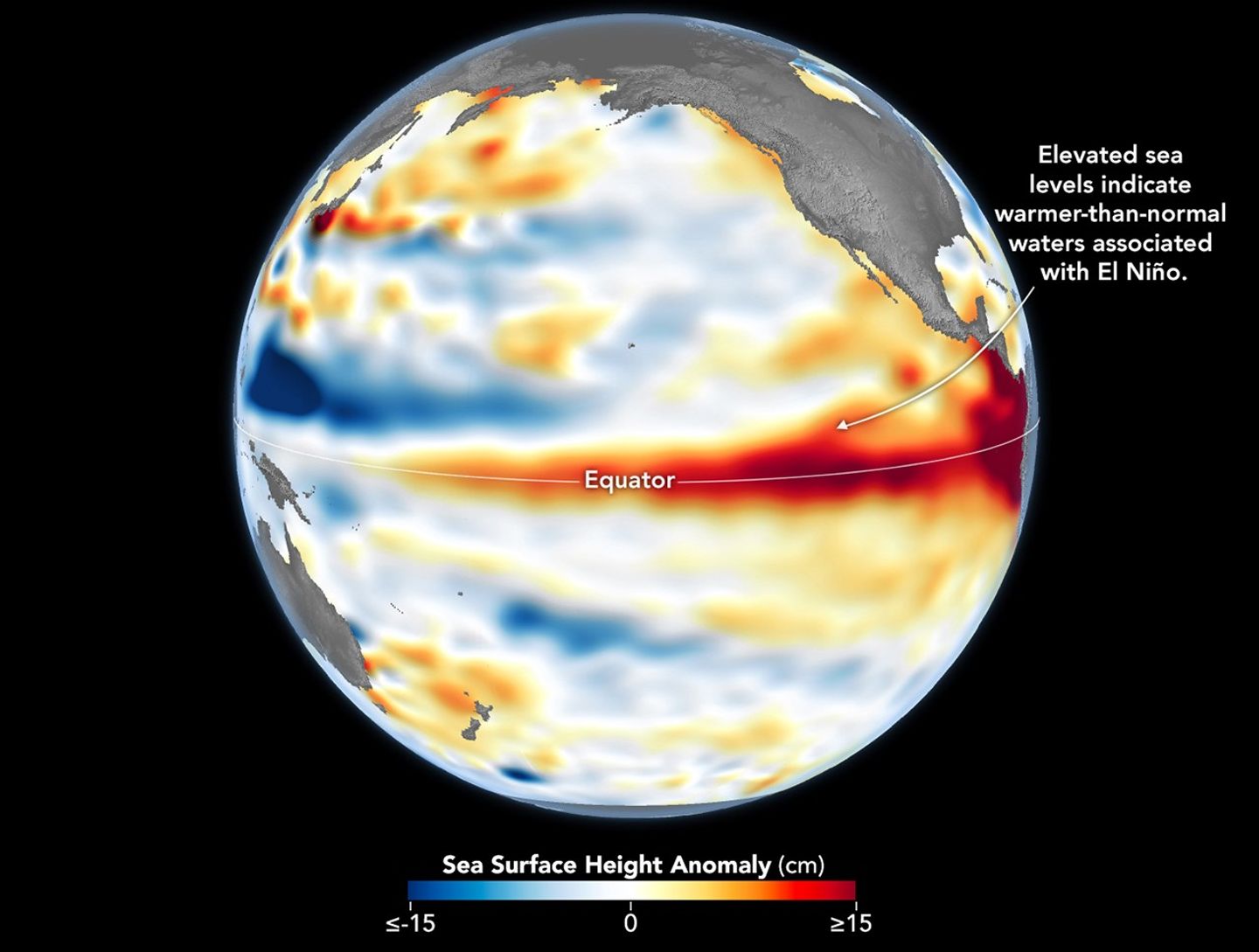
Higher-than-normal sea surfaces (red) are visible in the central and eastern Pacific on June 8, 2026, a few days before El Niño was declared. Data for the map were acquired by the Sentinel-6 Michael Freilich satellite and processed by scientists at NASA’s Jet Propulsion Laboratory (JPL).
NASA Earth Observatory/Lauren Dauphin
El Niño, characterized by warmer-than-normal water temperatures in parts of the equatorial Pacific, made its return in June 2026. Observations of sea surface height from the Sentinel-6 Michael Freilich satellite that month indicated that the 2026 event was continuing to strengthen.
The natural, recurring phenomenon can have widespread effects, typically bringing wetter conditions to the U.S. Southwest and drought to countries in the western Pacific, such as Indonesia and Australia. NOAA declared an El Niño on June 11, after sea surface temperatures in the central and eastern equatorial Pacific measured at least 0.5 degrees Celsius above average for several consecutive months.
Meanwhile, NASA scientists have been observing a complementary sign of El Niño: areas of elevated sea surface height. When ocean water warms, it expands in volume and causes the sea surface to rise—making the water’s height a reliable indicator of ocean temperatures. Warmer-than-normal temperatures, hence higher sea surface heights, in parts of the equatorial Pacific Ocean are associated with El Niño.
The map above depicts sea surface height anomalies across the central and eastern Pacific Ocean as observed on June 8, 2026. Shades of red indicate sea levels that were higher than average. Normal sea level conditions appear white, and lower areas are blue.
Data for the map were acquired by the Sentinel-6 Michael Freilich satellite—launched in 2020 by NASA and led by ESA (European Space Agency)—and processed by scientists at NASA’s Jet Propulsion Laboratory (JPL). Note that signals related to seasonal cycles and long-term trends have been removed to highlight sea level anomalies associated with El Niño and other short-term natural phenomena.
Earlier in spring 2026, the satellite started to detect precursor signs of El Niño as swells of warm water hundreds of miles wide, known as Kelvin waves, moved from the western Pacific to the eastern Pacific. That happens when trade winds in the western equatorial Pacific weaken and then temporarily reverse to blow from the west. Warm water piles up in the east, deepening the warm surface layer, lowering the thermocline, and suppressing the upwelling that usually keeps waters along the Pacific coasts of the Americas cooler.
This buildup of heat beneath the water’s surface is what sea surface height observations capture. It goes beyond surface temperature measurements to indicate how much heat is stored in the subsurface. That’s important because a shallow warm layer might not have much impact on climate and weather, while a large reservoir of heat below the surface can matter more.
According to JPL sea level researcher Severine Fournier, deputy project scientist for Sentinel-6 Michael Freilich, conditions in the western Pacific on June 8 looked similar to those from the same time in 1997, a year when an exceptionally strong El Niño emerged. Warm conditions in the eastern Pacific in 2026 have lagged behind, however, with fewer Kelvin waves built up by the same date.
Still, more warm Kelvin waves appeared to be approaching the eastern Pacific, meaning El Niño was still strengthening. Whether it catches up to 1997 depends on ocean activity in the coming weeks. “For now, it looks like it’s going to be a big one—more so than I would have said last week—but we still need more observations to know what’s going to happen.”
NASA Earth Observatory image by Lauren Dauphin, using modified Copernicus Sentinel data (2023) processed by the European Space Agency and further processed by Josh Willis, Severin Fournier, and Kevin Marlis/NASA/JPL-Caltech. Story by Kathryn Hansen.
China continued its accelerated launch pace with a series of missions, but long silence followed liftoff of a Kuaizhou-11 solid rocket Wednesday, suggesting potential issues.
Amazon now has hundreds of flight-ready satellites standing idle in Florida, waiting to join the company's low-Earth orbit Internet constellation, an Amazon official said Tuesday.
"They're built, and sitting in a payload processing facility waiting for trips to orbit," said Steve Metayer, vice president of Amazon Leo Production Operations, during a teleconference with reporters. "And we're currently manufacturing several satellites a day."
Metayer spoke on the eve of the company's next mission, during which an Ariane 64 rocket will launch three dozen Amazon Leo satellites into orbit from a spaceport in French Guiana. Liftoff is targeted for 7:53 am ET (11:53 UTC) on Wednesday.
Le prochain vol de la fusée européenne Ariane 6 est prévu pour le 17 juin. Il s'agira du premier décollage dans cette configuration avec quatre nouveaux propulseurs plus puissants pour mettre en orbite la charge utile la plus importante jamais envoyée par ce lanceur.
Nearly three out of every four images obtained by NASA’s new SPHEREx space telescope revealed something many astronomers were afraid of: contamination by artificial objects humans are launching into space.
The findings were reported in a new preprint paper by researchers at NASA’s Ames Research Center, who say that 73.3% of all the images the telescope captured over four months last summer revealed evidence of at least one trail left by SpaceX satellites or other orbital spacecraft.
What may be worst of all is that astronomers aren’t surprised.
With its mission to map the night sky in near-infrared light, NSA’s Spectro-Photometer for the History of the Universe, Epoch of Reionization, and Ices Explorer (SPHEREx) relies on long-exposure imagery that enables it to map large regions of the sky with every viewing.
Unfortunately, long-exposure photography is also ideal for capturing the movement of satellites, an increasing number of which have been placed in orbit in recent years.
Equally troubling is the fact that SPHEREx, from its own position in Earth orbit, had been positioned at an altitude where it was hoped that the number of satellite streaks could be limited. Yet despite such efforts, the new paper featured at the arXiv preprint server reports that, on average, at least two satellite trails were detected in every exposure.
Satellites Mistaken for Cosmic Rays
Astronomers have been raising concerns about this problem already for some time, and presently, there doesn’t appear to be any near-term solution.
Even beyond image contamination, the preprint study also found that several satellites that enter SPHEREx’s field of view are bright enough that they are also triggering the space telescope’s automated system that protects its delicate components from stray cosmic rays.
Designed to shut down the telescope’s data collection when it detects what it suspects are cosmic rays, the new research reveals that some satellites reflect enough light to engage algorithms that control this defense system.
Even in instances where imagery is successfully obtained, albeit with contamination from satellites, the brightness of these orbital objects can effectively obscure objects behind the portions of the telescope’s images where the satellites appeared.
In the images above, several examples of satellite trails are shown in SPHEREx imagery collected during the summer months of 2025 Image Credit: NASA/Borlaff, et al/arXiv.org).
A Growing Concern
The new SphereX findings are only the latest indication that astronomers were right to be concerned about potential light pollution from satellites. In a past study by Sando Kruk and colleagues, Hubble Telescope images had shown an increase in the number of satellites crossing its field of view, rising from contamination shown in just 2.8% of its images, to 5.9% over a period of two decades.
Ideas about how to prevent the issue have focused on using anti-reflective coatings on satellites and other means of reducing their brightness once they reach orbit. However, many modern satellites are large enough that having darker exteriors doesn’t help to significantly mitigate the amount of light they can reflect.
Additionally, the study’s authors note that “Optical reflections are just a fraction of the problem, since satellites also emit and reflect [infrared],” meaning that optical darkening efforts “might even increase their temperature, making them brighter in the IR.”
Worse Before It Gets Better
According to the study’s authors, the problem is likely to worsen before astronomers see any improvements.
“Remarkably, some private operators have announced the intent of deploying 4000 purposely high reflective satellites,” the researchers write, which aim to provide “sunlight on demand.” Such artificial orbital systems, if successfully deployed, would reflect light as much as five times the brightness of the full Moon onto areas of the Earth roughly five kilometers in diameter.
This, the team argues, would potentially have “a catastrophic impact to the quality of the dark sky and the Earth’s inhabitants.”
Fundamentally, the authors hope that bringing additional attention to such issues with their recent study may help to mitigate future concerns about our ever-brightening night sky.
“The widespread contamination addressed in this paper affects multiple areas of astronomical research,” the team says, which they say includes “the study of transient phenomena, deep imaging surveys, spectroscopic studies, and the search for Near-Earth Objects (NEOs), thereby hindering our ability to understand the Universe and protect the Earth.”
The new paper by Alejandro S. Borlaff and colleagues, “SPHEREx confirms predictions for artificial satellite trail pollution in Low Earth Orbit,” appeared at the preprint arXiv server.
Micah Hanks is the Editor-in-Chief and Co-Founder of The Debrief. A longtime reporter on science, defense, and technology with a focus on space and astronomy, he can be reached atmicah@thedebrief.org. Follow him on X @MicahHanks, and at micahhanks.com.

 Login