Login
Apple mostra busca inteligente na galeria! #siri #wwdc #apple
8 June 2026 at 20:45

#Apple #Siri #WWDC2026 #iOS27 #AppleIntelligence #iPhone #Fotos #Galeria #InteligenciaArtificial #IA #Tecnologia #AppleEvent #iOS #TechNews #Smartphone

NASA's Artemis II crew are the fastest people alive, and now they have the patch to prove it.
Mission Commander Reid Wiseman, pilot Victor Glover, and mission specialists Christina Koch and Jeremy Hansen (the latter with the Canadian Space Agency) spent 10 days in early April flying by the Moon. Their journey took them farther away from Earth than any humans have gone (52,756 miles [406,771 km]) and then, on the way back on board their Orion spacecraft Integrity, they sped up to about 24,664 miles per hour (39,693 k/ph) reentering the atmosphere.
Only three other people in history have traveled faster. NASA's Apollo 10 astronauts Thomas Stafford, John Young, and Eugene Cernan set the record for the highest speed attained by a crewed vehicle relative to the Earth's surface: 24,791 mph (39,897 kph) on May 26, 1969.
© Reid Wiseman/A-B Emblem/collectSPACE
Google's NotebookLM was one of the company's first forays into generative AI technology, and in un-Googley fashion, it hasn't been shut down yet. In fact, NotebookLM is getting one of its biggest updates, ever, today, moving to the latest Gemini 3.5 model, support for more file types, and streamlined web source integration. Google also says NotebookLM will be able to do more with all those queries thanks to embedded support for Antigravity.
Gemini 3.5 Flash debuted at Google I/O this year, promising much faster and more efficient processing. Google has claimed that companies worried about token costs can save big by moving their projects to the new Flash model while also getting outputs that are of similar or better quality. Those improvements are now filtering down to other Google products. NotebookLM, which launched in 2023 at the very beginning of the AI boom, lets you analyze specific sources like documents and webpages with Google's latest AI models.
The upgraded NotebookLM beats the old version in all of Google's "core evaluation dimensions."
Credit:
Google
Google conducted side-by-side evaluations of NotebookLM on the old Gemini 3.1 branch and with the updated 3.5. The company is being somewhat vague about the nature of the tests, breaking things up into "top five core evaluation dimensions," which are Accuracy and Quality, Multilingual Support, Large Document Analysis, Document Creation, and Advanced Research. In these tests, Google says NotebookLM averaged a 65 percent win rate versus the older model.
Humanity has littered the sky with the refuse of fossil fuel use, releasing enough CO2 to change the planet’s climate. We are also chucking incredible sums of carbon in the form of plastics into landfills and into the environment around (and inside of) us. What if cleaning up one of these problems could also help clean up the other?
A new study led by Ruth Ebenbauer at Aarhus University experiments with this idea by upcycling discarded polystyrene into (part of) a material commonly used in carbon-capture systems.
This material is based on amines—a simple chemical group that conveniently acts like a sponge for CO2. An amine will grab CO2 molecules when exposed to them, but let go of the CO2 when heated or depressurized, leaving it ready to go again. The first “CO2 scrubbers” tried in smokestacks used amines dissolved in water to do this, but solid amines are used in all kinds of carbon-capture systems now because they require less energy. These solid materials—often made into granules similar to the activated carbon in a water filter—have high surface area and high porosity, so the amines can efficiently partner up with CO2 molecules.
© Jamesmcq24

Dozens of cryptographically verified open source packages from Microsoft were compromised late last week to add advanced credential-stealing code that was triggered when developers opened them in AI coding agents.
In all, multiple researchers said, 73 packages were flagged as malicious when automated systems on GitHub blocked them on the platform. Rather than noting they are malicious—and that developers who used AI agents to work with them should assume their systems are compromised—the Microsoft-owned GitHub said it disabled the packages “due to a violation of GitHub's terms of service.” The text went on to encourage the package owner to contact GitHub.
It wasn’t until Monday that Microsoft even raised the possibility the packages were infected. In an email, the company stated: “We have temporarily removed some repositories as we investigate potential malicious content.”
© Getty Images
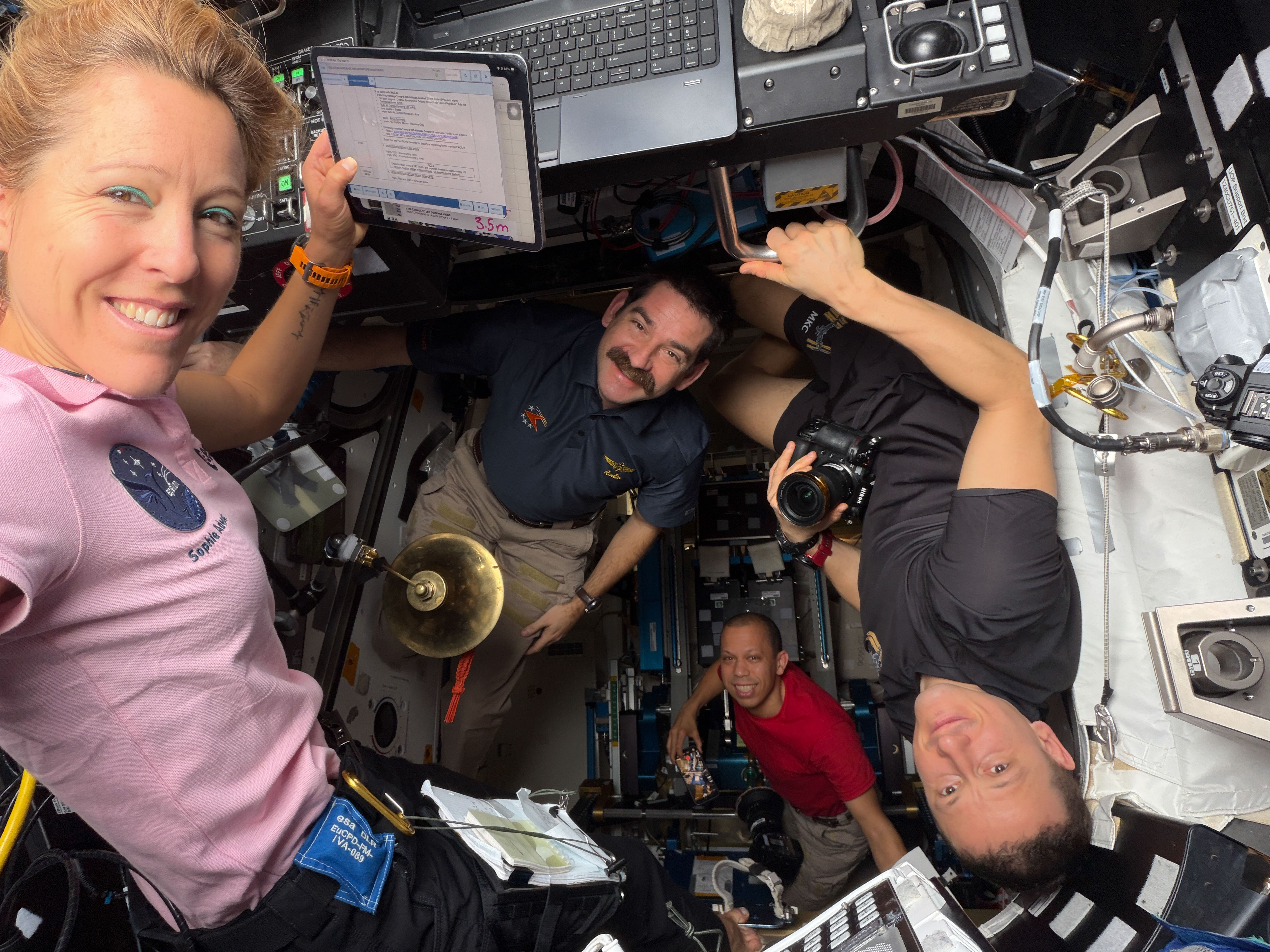
Expedition 74 began the week bioprinting human cartilage tissue and harvesting alfalfa plants aboard the International Space Station to advance health and promote self-sustainable space crews. The orbital residents also retrieved materials exposed to the external space environment and conducted their own ultrasound vein scans to continuously learn how living in space affects physics and biology.
NASA flight engineer Jessica Meir opened up the Kibo laboratory module’s Life Science Glovebox on Monday and set up a bioprinter to produce viable cartilage tissues aboard the orbiting laboratory. NASA flight engineer Chris Williams assisted Meir collecting the frozen cartilage samples for thawing then mixing the living cells with a gel-like bioink for placement in a printing cartridge. The biotechnology study tests the manufacturing of cartilage in weightlessness to increase its stability for printing on demand implants using a patient’s own cells to treat a range of health conditions.
Earlier, Williams began his shift with NASA flight engineer Jack Hathaway harvesting alfalfa plants inside the Columbus laboratory module’s Veggie facility. The astronauts collected the plants and roots for photographing, placed the botanical samples inside foil, then stowed them inside a science freezer for later analysis for the Veg-06 study. Insights may lead to the development of advanced methods to grow plants for food on future space missions.
Afterward, Hathaway scanned Williams neck, shoulder, and leg veins using the Ultrasound 3 biomedical device as doctors on the ground monitored in real time. Roscosmos cosmonauts Sergey Kud-Sverchkov and Sergei Mikaev also took turns scanning each other’s veins with the Ultrasound 3. The ultrasound imagery will help researchers protect crew members from space-caused blood clots.
Flight engineer Sophie Adenot of ESA (European Space Agency) and Meir joined each other during the first half of their shift retrieving containers of samples from Kibo’s airlock that were placed outside the orbital outpost for a materials exposure test. The samples included radiation shields, crew suit fabrics, optical fibers, and more to help engineers build robust technologies that can survive harsh environments both on Earth and in space.
Sergey Kud-Sverchkov and Sergei Mikaev, the orbiting lab’s commander and flight engineer, spent the majority of their shift inspecting and servicing the Zvezda service module’s treadmill. The space station’s other treadmill, COLBERT, is located in the Tranquility module.
Roscosmos flight engineer Andrey Fedyaev spent the first half of his shift locating and identifying computer components and video gear in the Zarya module to update the station’s inventory management system. Fedyaev wrapped up his day studying using artificial intelligence tools to boost crew efficiency and communications.
Learn more about station activities by following the space station blog, @space_stationon X, as well as the ISS Facebook and ISS Instagram accounts.
Get the latest from NASA delivered every week. Subscribe here.
The post Crew Begins Week with More Cartilage Printing and Plant Harvesting appeared first on NASA Science.
Apple has taken the wraps off of its next-generation operating system updates at its Worldwide Developers Conference today, including iOS 27, iPadOS 27, and macOS 27 Golden Gate. And while the long-awaited Siri AI update is the headliner, Apple also emphasized its efforts to optimize its software, improving its performance and reliability.
For starters, the company is continuing to refine the Liquid Glass design language that it introduced last year. A slider in the Settings will allow users fine-grained control over the translucency of the Liquid Glass effect, ranging from maximally transparent and glassy to fully tinted. Last year's redesigned icons are also being re-redesigned with more glass layers, which Apple says will make them sharper and more distinctive.
On macOS, Apple has also changed the way app toolbars and sidebars work, making toolbars more distinct, making the contents of sidebars extend all the way to the edge of the window, and reintroducing color to sidebar icons. Mac windows are also getting a "tighter corner radius," to address complaints about the way window resizing works in macOS 26 Tahoe.
© Apple
Aviation is entering a strange but exciting phase.
For decades, most passenger aircraft have followed the same basic design: a long tube, two wings, and engines under the wings. But that may not remain the case forever.
A new generation of aircraft is progressing at different speeds, ranging from early research concepts to full-scale flight demonstrators. Some are focused on cutting fuel burn. Others are built around electric propulsion, hydrogen, or completely new aircraft shapes.
Not all of them will enter service quickly. Some may arrive by the late 2020s, while others may take until the 2030s or even later. But all of them show where the future of aviation could be heading.
Boeing’s X-66A is not a normal passenger plane. It is a NASA-backed demonstrator designed to test a new wing concept.
The aircraft uses an ultra-long, thin wing supported by diagonal trusses. This design is called the Transonic Truss-Braced Wing. The idea is simple: longer and thinner wings can reduce drag, but they need extra support to remain strong.
NASA and Boeing expect the design to cut fuel burn by around 8–10% compared with the best single-aisle jets available today. The first flight is planned for 2028.
If the technology works, it could influence the next generation of 130- to 210-seat aircraft in the early-to-mid 2030s.
The Heart Aerospace ES-30 is one of the more practical aircraft on this list.
It is a 30-seat hybrid-electric regional aircraft designed for short routes. On battery power alone, it can fly up to 124 miles (200 kilometers) with zero emissions.
In hybrid mode, its range can increase to around 249 miles (400 kilometers) with a full passenger load, or up to 497 miles (800 kilometers) with fewer passengers and reserves.
This makes it useful for short regional flights where fully electric aircraft may still struggle because of battery limitations.
Heart Aerospace is targeting entry into service around 2028. Airlines such as Air Canada, United, and Mesa have already shown interest through orders.
JetZero is developing one of the most radical aircraft designs on this list.
The California-based startup is working on a blended-wing-body aircraft, where the wings and fuselage are merged into one large lifting surface. Instead of looking like a traditional tube-and-wing airliner, the aircraft has a much wider, flatter shape.
The main advantage is efficiency. Since more of the aircraft helps generate lift, the design can reduce drag and burn less fuel. JetZero claims its Z4 aircraft could cut fuel burn and emissions by up to 50% compared with similar aircraft flying today.
The 250-passenger Z4 is expected to have a range of roughly 5,754 miles (9,260 kilometers).
Airbus’s ZEROe program is one of the biggest attempts to bring hydrogen-powered aircraft into commercial aviation.
The original goal was to introduce a hydrogen aircraft around 2035, but the timeline now appears more likely to move toward the late 2030s or around 2040.
Early concepts included hydrogen turbofan aircraft, turboprops, and even a blended-wing-body design. Airbus has since focused more on fuel-cell-driven electric propulsion, where hydrogen is used to generate electricity for propellers.
If successful, ZEROe could become one of the world’s first large zero-emission commercial aircraft.
Bombardier’s EcoJet is a futuristic business jet research project.
Like JetZero’s aircraft, it uses a blended-wing-body design to improve efficiency. Bombardier says the project could help cut emissions by as much as 50% compared with today’s business jets.
The company has already been testing an autonomous demonstrator with an 18-foot wingspan. The goal is to study aerodynamics, structures, and systems before applying the lessons to future aircraft.
There is no firm service date yet, but Bombardier sees EcoJet as a step toward the future of low-carbon business aviation.
The Flying-V is one of the strangest-looking aircraft concepts in development.
Created by KLM and TU Delft, the aircraft has a V-shaped design where passengers, cargo, and fuel are all placed inside the wings. It is designed to carry about the same number of passengers as an Airbus A350 while using around 20% less fuel.
A small-scale model has already completed its first flight. However, this is still a long-term project. Researchers believe a commercial Flying-V would not carry passengers before around 2040 at the earliest.
Eviation’s Alice is a fully electric commuter aircraft designed to carry nine passengers.
It completed its maiden flight in 2022 and showed how quiet, clean short-range electric aviation could look.
However, battery limitations have made the project difficult. Its expected range has been reduced to around 288 miles (463 kilometers), and entry into service has been delayed several times.
The project was also paused in 2025. Still, if the company can solve its funding and technology challenges, Alice, or an aircraft inspired by it, could become one of the first fully electric commuter planes to enter commercial service.
Taken together, these seven projects show that the future of flight is not a single silver bullet, but a portfolio of electric, hybrid, hydrogen, and radically aerodynamic designs converging on the same goal – drastically lower emissions and noise without giving up speed or range.
Earth is filled with places and phenomena so spectacular that they seem almost unreal.
From glowing skies to giant reefs, massive canyons, towering mountains, and roaring waterfalls, the planet’s greatest natural wonders show just how powerful and diverse nature can be.
While different lists exist, these seven natural wonders are unanimously celebrated for their scale, beauty, and uniqueness.
The Aurora Borealis, or northern lights, is one of the most magical sights on Earth. It appears when charged particles from the sun collide with gases in Earth’s upper atmosphere, creating glowing waves of green, pink, violet, and sometimes red light.
The display is never exactly the same twice, which makes it feel alive and unpredictable. Seen in polar regions on clear dark nights, it is one of the few natural wonders that can turn the sky itself into a spectacle.
The Grand Canyon in Arizona, USA, is one of the world’s most famous geological landmarks. Carved by the Colorado River over millions of years, it reveals layer after layer of rock that tells the story of Earth’s ancient past.
Its vast scale, steep cliffs, and shifting colors make it look different throughout the day. At sunrise and sunset, the canyon becomes especially dramatic, with light and shadow deepening its immense depth.
The Great Barrier Reef off the coast of Australia is the largest coral reef system on the planet. Stretching over an enormous area, it is made up of thousands of reefs, islands, and cays.
Beneath the surface lies a thriving world of coral, fish, turtles, sharks, and countless other species. It is not only beautiful but also ecologically vital, serving as one of the richest marine habitats on Earth. Its scale and biodiversity make it a true natural treasure.
The Harbor of Rio de Janeiro is famous for its stunning setting, where the sea meets steep mountains and rocky peaks. Sugarloaf Mountain and the surrounding coastline create a natural amphitheater around the city.
The combination of water, stone, and urban life gives Rio one of the most dramatic landscapes anywhere in the world. It is a place where geography and beauty come together in a way that feels almost cinematic.
Mount Everest is the highest mountain above sea level on Earth and one of the most iconic peaks in human history. Rising from the Himalayas, it stands as a symbol of endurance, adventure, and extreme natural grandeur.
Its snowy summit and harsh conditions make it both beautiful and formidable. For climbers, it represents one of the greatest challenges imaginable; for everyone else, it remains a breathtaking reminder of how high and powerful the Earth can be.
Parícutin, in Mexico, is one of the rarest natural wonders because people actually witnessed its birth. In 1943, a volcano erupted suddenly in a farmer’s field and began growing rapidly from the ground.
Within a short time, it had formed a new volcanic cone and reshaped the surrounding landscape. Unlike ancient mountains or reefs, Parícutin is a modern geological event, making it a unique example of nature creating something new before human eyes.
Victoria Falls, on the border of Zambia and Zimbabwe, is one of the largest and most powerful waterfalls in the world. The Zambezi River plunges into a deep gorge, creating a massive curtain of water and a cloud of mist that can rise high into the air.
The local name, “The Smoke That Thunders,” captures the sound and force perfectly. Victoria Falls is unforgettable because it combines raw power with extraordinary beauty in one dramatic scene.
Taken together, these seven wonders highlight the many forms greatness can take in nature. Some are visible in the sky, some carved into stone, some hidden beneath the sea, and others formed by fire or water.
What they all share is the ability to inspire awe. They remind us that Earth is not only our home, but also a planet full of extraordinary wonders waiting to be seen.
A little more than five years ago, a shiny white Falcon 9 rocket made its debut flight, boosting a Cargo Dragon spacecraft to the International Space Station. Over the next year, it would launch a pair of astronaut missions and a handful of commercial spacecraft.
But since then, this first stage booster, designated B 1067, has mostly flown Starlink missions. It has launched them one after another, always returning safely to a drone ship before undergoing refurbishment and flying again. Sometimes it has flown twice in a single month.
On Monday morning, B 1067 once again took to the skies, launching 29 Starlink Internet satellites into low-Earth orbit from Florida. Upon landing on the A Shortfall of Gravitas drone ship in the Atlantic Ocean, the vehicle completed its 35th mission overall, retaining its title as fleet leader for SpaceX.
© SpaceX
Editor’s Note: Astrobites is a graduate-student-run organization that digests astrophysical literature for undergraduate students. As part of the partnership between the AAS and astrobites, we occasionally repost astrobites content here at AAS Nova. We hope you enjoy this post from astrobites; the original can be viewed at astrobites.org.
Title: Dynamics of Planetary Rings Under Thermal Forces
Authors: Wen-Han Zhou et al.
First Author’s Institution: The University of Tokyo
Status: Published in ApJL
If you ask anyone what their favourite planet is, the answer you’ll most likely hear is Saturn. Why? Why else than the beautiful and intricate ring system surrounding the gas giant. The other gas and ice giants in our solar system — Jupiter, Uranus, and Neptune — have ring systems themselves but none quite as striking as Saturn’s. Would it surprise you to learn that astronomers’ best models have not yet totally explained why Saturn’s rings look the way they do?
In contrast, it may not surprise you to hear that people have been trying to explain the rings for as long as we have seen them with telescopes. We now know that planetary rings are collections of relatively small particles (think micrometre up to metre sized), most likely having once been the material of a larger body that was disrupted either by collisions or tidal forces. This material, due to the gravity of its local planet, is sculpted into a flat disc where more subtle interactions then lead to substructure forming within the disc such as gaps and ringlets. Many of these substructures are explained by well-understood physics — for example gaps being carved by embedded moonlets or resonances sculpting ring edges — though there remain some outstanding problems in our understanding.
The authors of today’s article set their sights on the problematic inner edge of Saturn’s A ring (Figure 1). They describe some mechanisms — namely the collisions of micrometeoroids within the rings — by which a sharp ring edge can be maintained, but there exists a gap in the understanding of how such an edge can form in the first place. All hope is not lost, though, as today’s authors reintroduce a physical process they call the “eclipse–Yarkovsky” effect, which seems to explain these phenomena.

Figure 1: A horizontally sliced image of Saturn’s rings shows the rich substructure and gaps within the various rings. Saturn, which is not shown here, would be to the left of the image. The authors of today’s article are particularly concerned with the bright and sharp inner (left side) edges of the A and B rings. Click to enlarge. [NASA/JPL/Space Science Institute]
The idea behind this process revolves entirely around light. When sunlight hits a particle within a planetary ring, non-absorbed sunlight imparts a little “bump” onto a particle, ever so slightly altering its trajectory. At the same time, some of the sunlight is absorbed into the particle, which heats it up; light is soon re-emitted via thermal radiation, which, again, can slightly change the trajectory of these tiny particles. From a point on the surface of each ring particle (see rightmost side of Figure 2), the photons from this thermal radiation are all emitted in random directions; however, across the whole surface of the particle there is a net force! These tiny particles are spinning, and so the side just near “sunset” is hottest and emitting the most thermal photons. In this way, the pressure from the sunlight plus the thermal radiation of each particle imparts a net torque on the ring itself which changes the angular momentum of the ring.
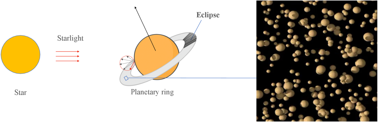
Figure 2: Starlight is the main source of light onto the particles that make up a planetary ring (right panel) though reflected light from the planet’s surface hits it too. This light “heats up” the ring and forms an asymmetry as the ring is eclipsed by the planet, which produces a net force. [Zhou et al. 2026]
After today’s authors detailed all of the math involved in this process (and there is a lot), they put it into practice to try to help explain Saturn’s curious rings. Including the eclipse–Yarkovsky effect together with other known effects that drive ring evolution allowed them to reproduce the optical depth profile (how thick the ring looks) of Saturn’s A ring better than ever before (notably the sharp inner edge in Figure 3). On top of this, the effect provides another avenue for moonlet formation in the outer edges of ring systems as the positive torque from the effect drives material out toward and away from the Roche limit.
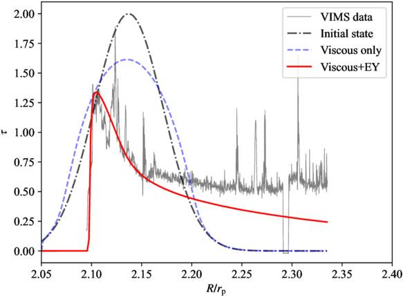
Figure 3: The authors try to explain the current structure of Saturn’s A ring by initialising it with a Gaussian profile of optical thickness versus radius (black dot-dashed line) and evolving it for 81 million years under different effects. When viscous effects are included (blue dashed line), the ring spreads out, but it’s only when the eclipse–Yarkovsky (EY) effect is included (red line) that the model closely matches the observed data (grey line). [Zhou et al. 2026]
Original astrobite edited by Wasi Naqvi.
About the author, Ryan White:
I am a first-year PhD student at Macquarie University in Australia, working mainly on binary/multiple systems with massive stars (Wolf–Rayets in particular!). Outside of study, I’m probably drinking coffee, baking, reading, or going for a run. You can also find me procrastinating on Bluesky @astroryan.bsky.social.
The post Shining a Light on the Shadowy Movements in Saturn’s Rings appeared first on AAS Nova.
Simulations suggest that tidally locked planets have similar atmospheric escape rates to Earth analogs despite having cooler and drier atmospheres near their surfaces.
The post The Response of Planetary Atmospheres to the Impact of Icy Comets. III. Impact Driven Atmospheric Escape appeared first on AAS Nova.
When I talk to my son, an engineering student, and we have a question or disagreement, he immediately turns to ChatGPT as his primary source of information and confirmation.
He is not alone in this. The use of generative AI tools has exploded across different demographic groups. For many people, these tools can be entertaining, informative and beneficial. However, they also have a dark side.
Generative AI is not formally recognised as addictive right now – the medical evidence is still being gathered. But there is a significant amount of data showing heavy use of chatbots and other systems that produce text, images and video leads to neural patterns and behaviour that are associated with addiction.
In light of Meta’s and YouTube’s recent legal defeat in a landmark social media addiction trial, I believe it’s time to ask whether a similar logic applies to generative AI – and how it could be addressed. The starting point would be to identify who carries responsibility for overuse of generative AI.
The science on this is not settled, and there are some who counsel caution when using the term addiction. They propose the use of other expressions such as “problematic use”. However, in a recent paper, our team of researchers suggest there is strong evidence to suggest that generative AI has addictive properties.
Much-discussed examples include emotional dependency on chatbot companions, compulsive engagement with them, and the loss of real-world acquaintances and friends.
A key factor here is that, as in all cases of addiction, the behaviour has negative consequences for the user which may affect both their personal and professional lives.
If we follow the argument that generative AI is a candidate for addictive behaviour, then we also need to look at responsibility. Societies tend to find ways to deal with harm by holding people or groups responsible for fixing it. Those who could be accountable include legislators, regulators, industry and health systems.
Historical precedents such as smoking might offer insights into how the area of generative AI addiction could evolve.
Older readers may remember when the Marlboro Man would appear before any feature movie in their local cinemas. It eventually transpired that not only was smoking addictive and bad for your health, but that tobacco companies knew this. Nevertheless, it was publicly denied.
This led to lengthy and high-profile litigation, eventually resulting in large-scale financial payouts and changes to the industry. These changes included the plain packaging of tobacco products and gruesome warning labels on them.
Gambling could be following a similar trajectory – and now social media companies may be taking their first steps into a similar process.
A key question is whether the makers of a product – be it tobacco, gambling or social media – are aware of its addictive properties. Another important factor being considered is whether certain companies may even use the allegedly addictive properties of their products for corporate advantage.
AI is not tobacco, of course, but there may be parallels to be studied.
In our research, we have identified four groups of stakeholders that are now being called upon to address the challenges linked to the possibility of addiction to generative AI.
The first is governments and regulators. These have a key role to play in highlighting the problems, setting the rules of engagement, and creating incentives for other parties to engage with the topic.
They can do this by requiring labelling, restricting advertising, applying liability law and providing research funding – along with many other mechanisms.
But the most important role in addressing potential addictive behaviour associated with generative AI would be held by big tech companies that develop and own these technologies – and stand to benefit financially from them.
These companies own and have access to user data, which would be needed to ascertain the features that support or alleviate addiction. They are also the parties that would benefit financially from addiction by increasing user numbers and engagement, the main currency of the digital age.
In addition to these two groups, academic researchers have an important role in collecting and interpreting data, and providing the evidence needed to recognise addiction and addictive features – in ways that allow for evidence-based political or legal debate.
Finally, civil society organisations such as user or patient groups can help by providing support, advocating for members’ interests, and establishing early-warning structures.
The point is that none of these interested parties can address the problem on their own. They need to collaborate.
A key problem at the moment is the lack of structured debate about responsibilities – everybody assumes it is someone else’s problem. But there is ample precedent showing how greater engagement from those involved with the issue may be achieved.
With tobacco, the World Health Organization (WHO) formed the Framework Convention on Tobacco Control – a treaty-based mechanism that brought together governments, public health bodies, researchers and civil society to evaluate evidence and draw up common rules. The International AI Safety Report shows comparable international consensus-building activities are already happening in other aspects of AI.
Some responsibility also falls on the users of AI, who should try to avoid or control their own potentially harmful behaviour. But appeals to individual moderation or mindfulness have been shown with other addictions to be insufficient.
While the harms associated with smoking or alcohol misuse are well known, society still relies on age limits, packaging rules and advertising restrictions. Generative AI is being integrated into the everyday fabric of our society. The choices we now make will determine what acceptable use looks like for years to come.
Bernd Stahl does not work for, consult, own shares in or receive funding from any company or organisation that would benefit from this article, and has disclosed no relevant affiliations beyond their academic appointment.
Everybody is watching to see what comes from Apple at its annual Worldwide Developer Conference (WWDC) today. There’s a great deal at stake, as when it comes to artificial intelligence (AI) today’s event represents an existentially important moment for the company.
Apple execs absolutely must convince developers, industry watchers, users — all of us — that it has learned from its well-publicized mistakes of the past two years and put together a serious proposition for AI across its platforms.
Right now, we think Apple intends to offer a hybrid of its own self-developed AI tools and services combined with others made with Google Gemini — all supported by an open approach to using AI services from third-party providers such as Anthropic or OpenAI.
When it comes to implementation, this should mean a contextually sensitive Siri that can respond to what you have on the screen of your device, or in the viewfinder of your camera app. The idea here is that you’ll be able to do contextual tasks like book restaurants or send a message to your granny, translate a sign, or even navigate around a room. More than this, you should also be able to combine tasks giving Siri complex — agentic AI — tasks it can then transact on your behalf.
Many of these functions will take place on device. Some will rely on Apple’s own fleet of Private Cloud Compute servers, supported by additional capacity from Google and Nvidia. When Apple Intelligence/Google Gemini can’t accomplish a task, you’ll be able to request that another service handle it on your behalf outside Apple’s managed garden. Siri itself will also gain a brand new interface.
As discussed here, developers expect Apple will make access to many of its new Apple Intelligence APIs available to them. This will let them deploy useful functionality in their apps at no charge, in part because the intelligence takes place on the device.
It will also be possible for developers to permit their apps to run without being opened, which means a user should be able to ask Siri to do complex tasks that also include functionality from their apps. During this past weekend, we were warned that some or all of the new Siri functionality might be introduced on a staggered basis using a waiting list.
Apple has come a long way since that tense meeting in early 2025 when the company’s senior leadership established a new approach to AI. With Apple CEO Tim Cook taking an uncharacteristic interest in driving his teams to pull their act together, Apple developed a new, partnership-based approach to try to recapture lost ground.
Has Apple finally regained the initiative?
To a great extent, that will be the big focus across the industry once the company tells us what it’s done. Cook’s final WWDC as CEO sees a company at the absolute top of its game in so many ways, including soaring Mac sales. But to some extent he will be judged on how successfully Apple’s AI pivot comes across.
Weekend analyst notes summed it up, with bears and bulls tossing insights along. In one camp, you’ll find the true believers who argue that if Apple does come to us with something convincing, it has a chance to absolutely dominate consumer AI. “Siri/Apple Intelligence 2.0 has the potential to become the ultimate AI resource offload and deliver a form of Agentic AI to the consumer at a lower cost than incumbents,” said Morgan Stanley analyst Eric Woodring.
Cynics, however, warn that Apple really must demonstrate the kind of contextual, agentic AI it first announced (and failed to ship) two years ago; they want a chatbot with muscle, and will see right through any attempt to place a PR veneer over something weaker than what others already provide. If Apple fails to deliver on this, it can expect its stock to be utterly savaged over the next few days, though some analysts believe that Apple’s previous missteps mean the damage is already priced in.
Ultimately, of course, in addition to convincing industry watchers, Apple will need to find a way to deliver the kind of AI power consumers have been told to expect — while also protecting privacy. If it does get that right, particularly if it truly exploits its powerful hardware to ensure the most common tasks take place directly on the device, it has a major opportunity to deliver a form of Agentic AI at a lower cost than incumbents can. And it can do so while leaving the core AI bubble to burst as and when it will.
Will Apple succeed? We’ll know in a few hours, when you should check back for first takeaways on what Apple has to share. Join me on the Core for the headline summaries.
You can follow me on social media! Join me on BlueSky, LinkedIn, Mastodon and The Core.
Autonomous taxi services, which have scaled rapidly across major metropolitan areas in the United States and China, are poised to break into mainstream European transit networks following a decisive regulatory shake-up.
The European Union has moved to eliminate fragmented regional transport laws by introducing a unified “testbed” approach for autonomous vehicle validation. The streamlined framework allows driverless fleet operators to bypass highly bureaucratic country-by-country approval processes.
Backed by European transport ministers, this policy shift removes long-standing regulatory friction and clears the way for extensive autonomous trials across major European capitals this season.
For years, autonomous tech firms have faced severe deployment delays across Europe compared to their international peers. While Waymo operates thousands of driverless rides in the US and Baidu’s Apollo Go blankets dozens of Chinese cities, Europe has lagged behind due to highly fractured cross-border safety rules.
Industry critics, including France’s high planning commissioner, have frequently lambasted the bloc for falling into regulatory stagnation while foreign operators built massive real-world data advantages.
The newly adopted testbed protocol directly addresses this imbalance. By establishing centralized baselines for safety, liability, and hardware evaluation, an autonomous platform approved in one EU member state can deploy test fleets across neighboring EU member states with minimal administrative delay.
This single-approval template transforms the financial calculus for mobility operators, allowing developers to aggregate real-world urban telemetry from a diverse mix of European driving conditions—ranging from high-speed roundabouts to historical narrow streets—without re-litigating safety certifications at every national border.
The regulatory loosening has immediately triggered an aggressive land grab among global ride-hailing networks, domestic automakers, and international AI developers. Several cities are at the forefront of this transformation, each playing a distinct role in the unfolding autonomous vehicle landscape.
Zagreb, Croatia serves as Europe’s primary operational testbed. In a collaborative venture, Croatian startup Verne—backed by hypercar manufacturer Rimac—has partnered with Uber and Chinese AI leader Pony.ai to run a pilot fleet of 10 fully driverless robotaxis on public roads.
London, United Kingdom is set to become a highly contested arena. Three major tech syndicates are initiating field trials this year. These include US sector leader Waymo, British autonomy pioneer Wayve (partnered with Uber), and Chinese tech giant Baidu’s commercial unit, Apollo Go.
Madrid and Munich are witnessing rapid continental expansions. Chinese developer WeRide has partnered with Uber to run dynamic fleet testing in the Spanish capital, while German roads will see Uber vehicles integrated with Momenta and Autobrains AI control suites.
Despite the regulatory momentum, industrial analysts warn that market forces and political goals in Europe remain sharply misaligned. Management consulting firms like Boston Consulting Group predict that by 2035, the global operational volume of robotaxis will reach roughly three million vehicles.
However, while China is projected to host 850,000 units and the US up to 350,000, Europe’s stringent municipal laws and cautious investment profiles are expected to limit the continent to just 120,000 active autonomous commercial vehicles.
A primary sticking point centers on geographic targeting. Robotaxi developers are intensely focused on high-density, lucrative downtown districts where ride-hailing demand peaks and software routing is highly profitable.
Conversely, local European policymakers are pressuring tech firms to deploy their fleets in suburban and rural outer rings to fill critical gaps left by shrinking public transportation budgets.
Reconciling this economic mismatch—while transitioning vehicle designs through highly specialized validation testing—will dictate whether Europe’s newly fast-tracked autonomous networks achieve commercial viability or remain restricted to hyper-localized pilot loops.
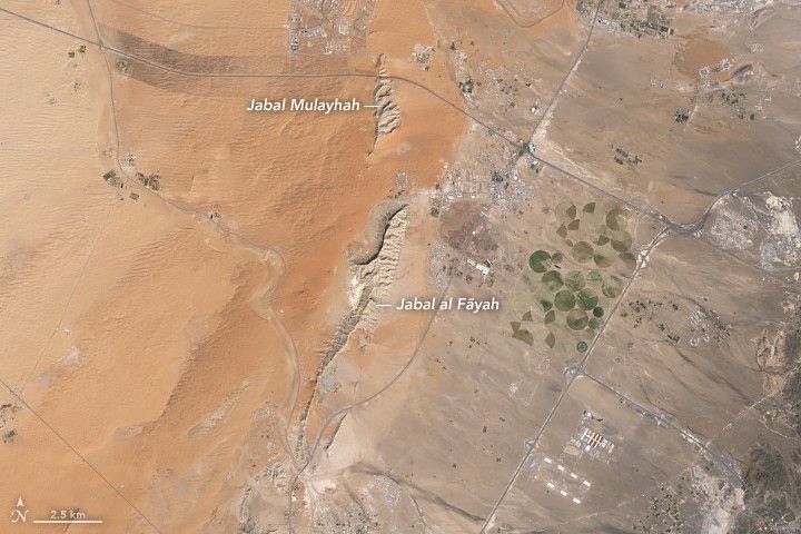
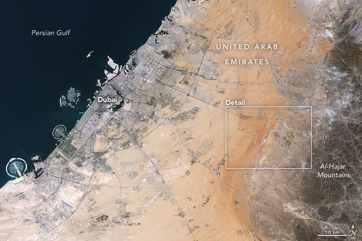
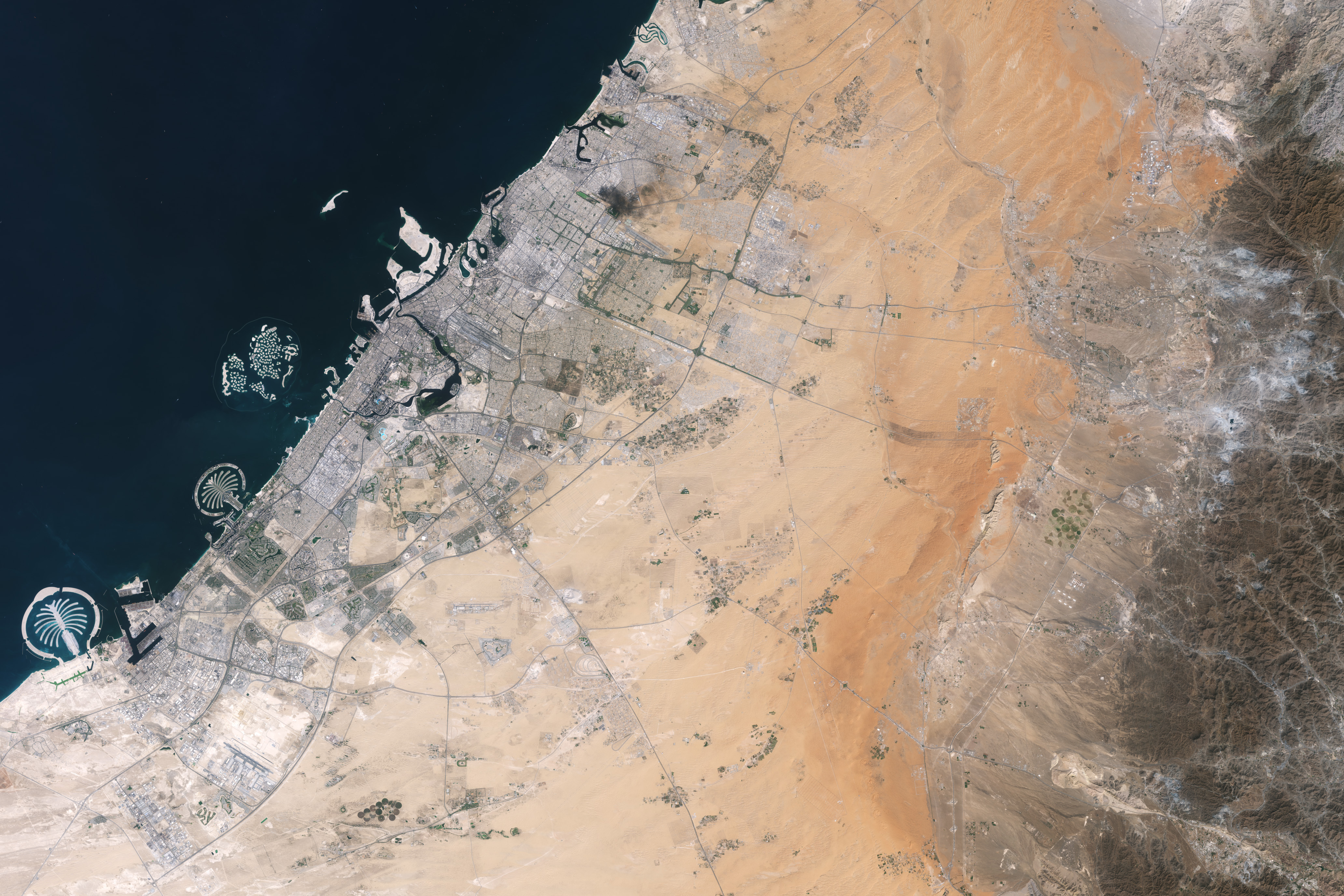
About an hour’s drive east of Dubai’s gleaming towers and artificial islands, a quieter, more natural landscape takes shape. At the far northern edge of the Rub’ al Khali, a saffron-colored sand sea laps against the Al-Hajar Mountains. A series of pale ridges rises finlike from the desert plain, with the largest—Jabal al Fāyah—standing 412 meters (1,352 feet) above sea level.
The Landsat 8 satellite captured this image of the ridges cutting across the Emirate of Sharjah in the northern part of the United Arab Emirates on October 23, 2025. To geologists, the limestone ridges are a reminder of the region’s watery past, signs that this land lay underwater tens of millions of years ago when the sedimentary rock layers were deposited.
Jabal al Fāyah functions as a barrier, trapping windblown sand in dune fields to its west. The weathering of iron-bearing minerals in the sand grains gives the dune fields their orange hue. To the east, the branching channels of overlapping alluvial fans extending from the Al-Hajar Mountains carry gravels and eroded sediments from basalts and other dark mafic rocks.
The dark rocks to the east—part of the Samail Ophiolite—are known to geologists for being among the world’s largest, best-preserved, and most accessible exposures of ancient oceanic lithosphere, the rigid outer layer of Earth that includes both the crust and upper mantle. Oceanic lithosphere like this is normally subducted and recycled back into the mantle when tectonic plates collide. But in this area, a large section from beneath the Tethys Sea was scraped off and thrust onto the Arabian plate in a process called obduction.
The Jabal al Fāyah ridges themselves are made up of marine limestone that was deposited on top of the ophiolite over tens of millions of years spanning the late Cretaceous through the early to mid-Paleocene. Limestone typically forms along continental margins in warm, shallow oceans, often in lagoons and coral reefs, out of the calcium carbonate found in the shells and skeletons of marine life. In many parts of the ridges, coral fragments and marine invertebrate fossils are visible embedded in the rock. A feature called Fossil Rock sits a few kilometers north of Jabal al Fāyah and adjacent to the limestone ridge Jabal Mulayḩah. It contains an abundance of snail, clam, and sea urchin remains.
For archaeologists, the ridges are at the center of a much more recent tale of human adaptation and survival that has played out in just the past few hundred thousand years. The ridges and parts of the surrounding landscape—inscribed as a UNESCO World Heritage site in 2025—are dotted with dozens of archaeological sites that trace human occupation on the Arabian Peninsula back to between 210,000 and 120,000 years ago, to the Middle Paleolithic. That was a period when waves of anatomically modern humans (Homo sapiens) migrated out of Africa and shared the planet with other groups such as Neanderthals.
Many of the sites contain stone flakes, blades, scrapers, hand axes, and other stone tools. The archaeological treasure trove offers early evidence of modern humans surviving in a harsh desert environment and raises questions about the routes modern Homo sapiens may have taken on their journey out of Africa.
Geological evidence indicates that lakes periodically formed on the east side of the ridge, providing critical food and water resources that would have supported early inhabitants in this unforgiving climate. Rocky overhangs along the ridge would have provided shelter from the heat and wind. Some of the sites show evidence of intermittent occupation beginning as early as 210,000 years ago, making this one of the earliest signs of human habitation on the Arabian Peninsula.
NASA Earth Observatory images by Lauren Dauphin, using Landsat data from the U.S. Geological Survey. Story by Adam Voiland.
Stay up-to-date with the latest content from NASA as we explore the universe and discover more about our home planet.
The coastal province features striking tropical karst landscapes and sandy beaches alongside a mix of natural land cover and developed…
Ireland is best known for its many greens, but the striking grays of the island’s Burren region also stand out…
The circular geologic feature in northwestern Africa can be hard to recognize from the ground, but it is obvious when…
Subscribe to the Earth Observatory and get the Earth in your inbox.
NASA’s Earth Observatory brings you the Earth, every day, with in-depth stories and stunning imagery.
Explore Earth Science
Open access to NASA’s archive of Earth science data
From the air, you see it only through the constant jolt, tilt and shudder of the low-flying Cessna aircraft. The landscape of the Llanos de Moxos, northern Bolivia, appears as a disconnected patchwork of open grassland savannahs, forest islands and lakes.
It feels random, almost unreadable. Only gradually does the pattern resolve itself: raised causeways or paths fanning out to link the forest islands, and a dense, scattered web of canals threading the terrain. Slowly you realise it’s a structured network of intersecting lines, enclosures and roads – the imprint of past human design.

If you stand on the open savannah, there is almost nothing to see of this ancient network. The horizon feels open, with fires in the distance from local people burning pastures and clearing forest as dry season begins. The old geometry is still faintly perceptible, but you have to know how to look.
Step into the patches of forest and the canopy closes in. The earth softens underfoot and mosquitoes descend in relentless swarms. The sweat on your neck thickens into a humid film, carrying the familiar scent of suncream and the sharper, chemical note of DEET.
In the uneven light between the trees, the landscape dissolves into subtle rises and depressions. Against the rhythmic swish of machetes as our guides cut through the vegetation, your mind tries to piece together the fragments of structures into something coherent. Flying overhead doesn’t reveal anything about this forest area in the way that it does with the savannah. But fortunately recent advances in technology have transformed what we are able to see.

Archaeological explorations in this part of the world have been completely changed by lidar in the past couple of decades. Lidar maps an area from a plane or drone by bouncing rapid laser pulses off the Earth’s surface. Some of these pulses penetrate the forest canopy, reach the ground and reflect back to the sensor.
By measuring the return time, the system can generate highly precise three-dimensional models of the terrain. This allows you to strip away the camouflage of vegetation, making it possible to see what lies below the Amazonian forest for the first time.
It reveals the ancient Llanos de Moxos as not simply a collection of settlements, but an entire urbanised landscape. A large part in the south-east of this region belonged to the Casarabe culture, which dominated between around AD500 and 1400. It extends across 20,000km², which is roughly the size of New Jersey in the US.
The Casarabe organised into a hierarchy of four different sizes of settlements (those forest islands mentioned above). The biggest ones – the primary settlements – were as large as 3km² or 300 hectares. That’s enough space for over 400 football pitches, suggesting that they could have accommodated substantial numbers of people.

Welcome to our series on the great mysteries of archaeology. Viking explorers, Amazonian cities, artefacts from before civilisation. Archaeology may be all about the past, but it’s constantly shifting with every scientific discovery. This series will dig into some of the most fascinating debates in the field today.
These settlements connect along the raised causeways to smaller secondary and tertiary sites a number of kilometres away, all of which were permanently inhabited as opposed to empty ceremonial hubs. A fourth tier consists of groups of isolated mounds located out in the pampas, which likely correspond to dwelling areas occupied by farmers who would have worked the fields.
It’s not possible to show a lidar image of these four different types of sites interconnecting because they are too far apart for the resolution available, but the image below of a primary settlement known as Loma Cotoca shows the kinds of things we are now documenting.
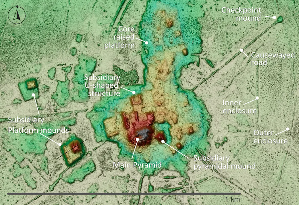
It features some very impressive civic-ceremonial architecture: conical pyramids over 20 metres tall and U-shaped structures that may have acted as areas for public gatherings for speeches or ceremonies. These were built on top of man-made platforms rising as much as five metres off the ground and extending over 20 hectares. To be clear, this is all still hiding under the forest, but the lidar data reveals the shape, height and layout of what lies below.
The volume of earth moved to create this architecture would have rivalled – and in some cases exceeded – that of well known Andean monuments such as Akapana a few hundred miles to the south-west on the other side of the Andes. Akapana was the epicentre of the Tiwanaku empire that dominated the southern Andes between about AD600 and 1000.

Yet where monuments like Akapana were surrounded by classic, compact bounded cities with thousands of inhabitants, the Casarabe equivalent was completely different. This was dispersed, low-density living amid extensive green space – a form of tropical urbanism that challenges longstanding assumptions about this area as sparsely populated and only lightly modified. It invites comparison with other low-density tropical urban landscapes such as the Maya in central America and the Angkor in latter day Cambodia.
Equally important is the coherence of the Casarabe system. The settlements are rarely isolated, part of a tightly connected network with shared water-management systems. It was clearly all planned and coordinated, designed not only as living spaces but for integrating the population across the region.
We can see that the Casarabe were sustained by drained-field agriculture: the canals were dug to make the land viable for planting during the wet season. The most prominent crop was maize, but there was a remarkable diversity of other produce. This was all embedded within a landscape that was engineered through reservoirs and farm ponds, which helped the Casarabe sustain cultivation and maintain access to water through the dry season in this extremely seasonal environment.
Also very noticeable is the fact that all the major architectural features and burial sites are oriented north-north-west. This suggests these people may have been led by cosmology, with important celestial bodies or regions of the night sky serving as symbolic reference points – hinting at a world where infrastructure, settlement and belief were inseparable.
The Casarabe culture covered much less than 1% of Amazonia, which is the whole tropical interior of South America, spanning close to half of the entire continent. For much of the 20th century, this vast area was viewed by archaeologists as an environment that was limiting for human existence.
Poor soils, scarce game, extreme El Niño floods and droughts, and the challenges of tropical disease were all thought to constrain human populations to small, wandering groups living off the land as best they could. Large, settled societies – let alone towns or cities – were considered unlikely, if not impossible.
This view began to shift in the late 20th century for several reasons. Archaeologists realised that Amazonian people had been domesticating a diversity of plants since the end of the Ice Age. They manufactured some of the earliest ceramics in the Americas, and also devised soils known as Amazonian Dark Earths, which combined charcoal, bone and waste materials with the existing poor-quality soil to make it fertile enough for widespread farming.
It also became apparent that just like the Casarabe people, many other cultures across Amazonia had reclaimed vast expanses of seasonally flooded savannahs over several thousand years to create raised and drained field systems.
These discoveries were evidence of long-term settlement and landscape management far beyond what was previously thought possible. It meant Amazonia was not simply a backdrop to human activity; much of the landscape was shaped over the last 13 millennia by the people who lived there.
Like lasers in the sky, lidar technology has accelerated this transformation in our understanding. The digital process feels near-magical, a “vegetation removal algorithm” that reveals the secrets below.
In practice, however, working with lidar in Amazonia is anything but straightforward. Running such a project here, as I have done, can feel like one of the greatest emotional rollercoasters in field archaeology. It’s all anticipation, frustration and sudden revelation – only comparable, perhaps, with shipwreck exploration.
Depending on what technology is available and most suitable for exploring a particular area, I’ve worked with lidar attached to drones, aeroplanes and helicopters. I’ve learned through trial and error that the technology is only as effective as the logistics and personalities behind it – above all on one occasion when we were trying to integrate a Hungarian lidar sensor with a Brazilian drone.

Lidar can perform beautifully one day and fail the next, depending on the equipment, weather, terrain, batteries, communications and the sheer difficulty of operating in remote Amazonian conditions.
Flights must be carefully planned in remote areas with limited infrastructure, where convective clouds, smoke from fires, wind and even vultures riding thermals can disrupt data acquisition. You have to arrange fuel in advance and improvise landings wherever a safe clearing can be found. Here’s our team refuelling a lidar helicopter in the football field of a small village in Acre state, western Brazil:
You also have to do constant troubleshooting with the technology, such as making sure it’s calibrated correctly and that the data from different flight paths all aligns. What appears in the final images as a seamless “removal” of the forest is, in reality, the product of improvisation, negotiation and persistence.

But given all these challenges, it makes the first successful images all the more powerful when they finally appear. The reward is that we’re finally finding the “lost civilisation” that explorers like Percy Fawcett were searching for a century ago, but by cajoling a drone rather than battering through jungle.
Incidentally, this technology also has important uses beyond archaeology. It can help people to locate and harvest crops like rubber or açaí palm fruits without having to clear so much rainforest. It is also used by pioneering projects such as Amazonia Revelada, which helps Indigenous and traditional people of the Amazon to prove their historic presence within an area to ward off modern commercial interests like loggers or farmers, while also protecting the living history and nature embedded in these landscapes.
Lidar surveys by French and Ecuadorian archaeologists have revealed that the Llanos de Moxos was certainly not the only example of large-scale, highly integrated society in Amazonia. The Upano Valley, which covers some 300-600km² on the mountainous forest of the Ecuadorian eastern flanks of the Andes, offers another striking example – this time from between about 500BC and AD600–700.
Lidar discovery areas

In Upano, archaeologists have been able to map a vast network of settlements connected by extensive road systems, with large platforms and clusters of buildings arranged in organised layouts across a broad area.
What stands out is not just the scale – thousands of structures – but the rigour of the planning. The settlements didn’t just grow randomly, but as part of a deliberate design: we see straight lines of flat-topped platforms laid out in repeating rows and connected by straight paths that cut cleanly across the landscape, as you can see below.
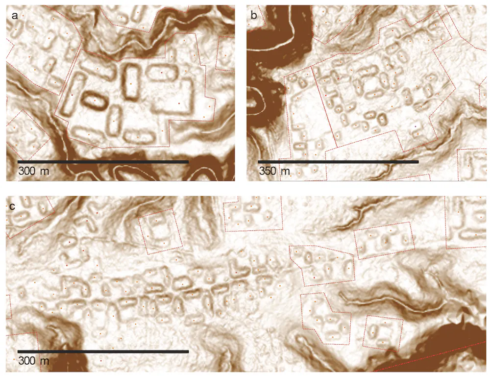
Again, this is not urbanism in the conventional sense of dense, continuous occupation. There would have been none of the vertical stacking of buildings that you’d get in European settlements, and there were also green spaces between platform complexes – much more like a forest city.
Like the Casarabe region, this is a distributed settlement pattern that is both open and highly structured, but the arrangement is much more compact. This reflects the limited flat space available on the upper terraces of the Upano River, which rise up to 100 metres above the surrounding landscape.
Elsewhere in Amazonia, we see more variations. In the Upper Xingu of central Brazil, interconnected settlements were arranged around a shared ceremonial and road network, again suggesting a regionally coordinated social world.
Further north, the Tairona people of the Sierra Nevada de Santa Marta in present-day Colombia built terraced stone towns in the mountains, linked by paved paths. This was a form of urbanism shaped entirely by the demands of steep, high-altitude terrain. Below is a lidar image of one area in this region, with the platforms that would have housed the settlements marked in yellow. Below that, you can see what the platforms look like.

In western Amazonia, Acre adds another important variation. From around AD1–1000, people built large ditched enclosures, or geoglyphs, mainly in the south-eastern part of this region along the upper Purus River. These were square, circular, hexagonal or octagonal mounds, often 1-3 hectares in size, with ditches up to four metres deep. These were probably used as ceremonial gathering places rather than permanent settlements.
After about AD1000, these were followed by what we call circular mound villages, occupied until around AD 1650–1700. They featured rings of mounds around central plazas and straight roads radiating out like the rays of the Sun, often built to align with the four main compass points. These “Sun villages” were true settlements, and formed interconnected networks across the southern rim of Amazonia. You can see an example in the lidar image below.

Taken together, these discoveries fundamentally reshape our understanding of Amazonia. We now see a mosaic of managed landscapes, engineered environments and, in some cases, city-scale societies. What unites them is not a shared blueprint but a shared impulse: the organisation of people, space and movement across large landscapes in ways that were deliberate, durable and distinctly their own.
To stress, Amazonia was not uniformly dense or urban. It supported a diversity of types of settlements, from dispersed networks like Moxos to tighter grids like Upano, each of them adapted to local ecological conditions. They shared a low-density urbanism, in the sense of large, interconnected populations without the density of classic cities.
How were these societies organised politically and socially? How did they interact with variations in the climate and environment, ranging from the heavy rainfalls and droughts caused by El Niño to rivers forging new routes that could move them away from a settlement within a few generations?
What, if any, connections existed with mountain societies in the Andes? And perhaps most importantly, since both the Casarabe and Upano ceased to build monuments after 1492, what led to their transformation or decline before the arrival of Europeans?
There is active debate between archaeologists over whether these societies transformed because of environmental stress, internal political change, or shifts in things like trade routes or migration.
In the Llanos de Moxos, one possibility is that a prolonged period of climate change affected the Casarabe water-management systems that were so critical to feeding this thriving society. In the Upano Valley, volcanic eruptions and earthquakes may have disrupted settlements and agriculture, although it’s unclear whether that could have led to the area being abandoned.
It seems likely that as we uncover new things, it will reveal more and more integration between different societies. What we are seeing now in Amazonia is much like looking at a satellite image of a country at night: bright, isolated clusters of light – cities that appear disconnected. But as we continue to expand our coverage and fill in the gaps, I think this will change.
What now appear as isolated clusters may also resolve into extensive networks. For example a study across the southern rim of Amazonia has predicted that the kinds of settlement mounds that have been identified so far are likely to occur across about 400,000km², supporting an estimated regional population of roughly 500,000 to 1 million people in the era before the Europeans arrived.
Entire regions may emerge as previously unrecognised centres of population and landscape management. This could be particularly so for the Llanos de Moxos. The whole area covers as much as 200,000km², depending on where you draw the boundaries, stretching into Brazil and even Peru. It is often divided into several apparently distinct cultural regions — the Casarabe (aka the monumental mound region), and then two others called the platform ridge and zanjas (ditches) regions.
As lidar coverage expands and more archaeological work is conducted, we may begin to understand how these societies were economically specialised. We know, for example, that the fortified villages of the zanjas region had fish weirs spanning hundreds of miles that were capable of capturing vast quantities of migratory fish. The platform ridge region consisted of large drained fields, which could potentially produce surpluses of maize. It is conceivable that these belonged to a broader network that supported the more complex Casarabe centres.
Or perhaps – who knows – the relationships were more fluid and reciprocal. For now, the question remains open. But it is precisely this possibility of deep regional integration that lidar is beginning to bring into view. In time, we may even begin to identify Casarabe outposts scattered across the Llanos de Moxos.
There’s still a huge amount to be done with lidar. Vast areas, particularly in the Ecuadorian and Peruvian Amazon – remain unexplored. One recent study suggested that there could be more than 10,000 more urban structures of the kind I’ve been describing still hidden throughout Amazonia, all of them dating from pre-European times.
Looking ahead 20 years, it is likely that our map of Amazonia will look very different. One promising technology is satellite-based lidar systems, which could provide broader, though less detailed, datasets across large areas. Advances in machine learning are also beginning to help us identify archaeological features within massive datasets, speeding up a labour-intensive process.
Against this, there are time pressures in some places. Llanos de Moxos, for instance, is unfortunately in rapid transition. The very ground that holds the traces of ancient networks is being transformed by mechanised agriculture and large-scale terraforming for rice cultivation and pastures.
We also need to keep reminding ourselves that lidar is only the first step. What really matters is how it’s brought together with other lines of evidence. Most sites discovered by lidar have yet to be excavated, so we’ll have to do much of that, looking for everything from bones and plants to ceramics and weapons.
So far, most excavation has been in the Casarabe area of the Llanos de Moxos. The reason, for instance, that we know the culture lived primarily on maize was through the discovery of over 60 human skeletons, which underwent carbon isotope analysis. The same research paper also analysed excavated duck bones to show that the Casarabe were feeding them maize too, suggesting animal domestication in a continent that was not generally known for it.
Another fascinating Casarabe find is a single buried skeleton who may have been a leader, because he had a collar of jaguar teeth around his neck. He was also wearing ear pieces made of armadillo shell, studded with mottled blue stones called sodalite – it’s not clear what these were for.

We’ll also need to obtain more precise dates for key events using techniques like radiocarbon dating, and more pinpoint accurate environmental data to help support theories about ancient changes to the climate – as opposed to the wider regional information we’ve tended to rely on until now. Lake sediments are great environmental archives, preserving evidence of things like vegetation change and landscape disturbance.
Also important is comparing genetic data from excavated bones with people who live in these areas today – in dialogue and collaboration with local communities whose histories, memories and knowledge are essential to understanding these landscapes.
It’s all a question of how lidar is brought together with all this other evidence. The most convincing reconstructions will come from the convergence of all of these. One further major challenge ahead, however, will be to bridge the gap between scientific reconstructions and how past peoples understood and inhabited their world. Archaeology is increasingly rich in data, but we have to relate it to lived experience.
That is no easy feat, but it is essential if we are to move from mapping past worlds to understanding them. Crucially, Amazonia – with its rich, still-vibrant Indigenous societies and ethnographic record – offers an exceptional opportunity to do this, providing rare continuities through which to anchor and critically engage our interpretations of the past.
My own sense is that we will move towards a view of Amazonia not as an exception, in line with the old view that the people lived within an untouched paradise, but as part of a broader pattern of human-environment interaction. The rainforest will be understood not only as a biological system, but as a historical one – shaped, in part, by the people who lived within it.
This does not mean the Amazonian people who simply lived “in harmony” with nature; the evidence points to something more interesting. Although Amazonian societies developed complex, and at times intensive, forms of land use, the evidence consistently shows that they often did so while maintaining continuous forest cover. Far from the large-scale deforestation that we might assume was necessary for such elaborate forms of human life, their practices created mosaics of managed forest, gardens, orchards, wetlands and settlement areas.
We know partly from lake sediment data that people enriched the forests with species that provided food, building materials, medicines and other resources, from açaí and cacao to palms, cinchona and copaiba. The fact that some of these species endure today suggests that past land use left lasting ecological legacies.

In the context of today’s climate crisis, the long-term balance that these people achieved offers a powerful lesson: it is possible to sustain complex societies without destroying the forest, if land use is guided by principles that integrate ecological knowledge, cultural values and a commitment to the continuity of the living landscape.
What lies beneath the Amazon is not just a hidden past. It is a reminder that even the most seemingly untouched landscapes can carry deep histories, waiting – sometimes just beneath our feet – to be revealed.
This article features references to books that have been included for editorial reasons, and may contain links to bookshop.org. If you click on one of the links and go on to buy something from bookshop.org The Conversation UK may earn a commission.
For you: more from our Insights series:
To hear about new Insights articles, join the hundreds of thousands of people who value The Conversation’s evidence-based news. Subscribe to our newsletter.
José Iriarte receives funding from the European Research Council, the Arts and Humanities Research Council, the British Academy, National Geographic and the Wenner-Gren Foundation for Anthropological Research.