❌

Normal view

South American 'Pompeii': Volcanic eruption 22 million years ago preserved a snapshot of the Andes forming

14 September 2026 at 21:51

A volcanic eruption 22 million years ago froze a snapshot of the Andes in their youth, revealing a slow-and-steady formation of this formidable mountain range.

The eruption, which originated from the Lauca Caldera in what is now northern Chile, blanketed the landscape in a formation known as ignimbrite. This rock is left over after a pyroclastic flow β€ͺ—‬ a mix of rock, volcanic gas and ash that sweeps over the landscape like a broiling tsunami. Pyroclastic flow is what buried the Roman town of Pompeii after the eruption of Mount Vesuvius in A.D. 79, preserving buildings and people where they fell.

Now, a new study published Sept. 11 in the journal Science Advances extrapolates the landscape under this Andean ignimbrite, revealing that it must have buried rolling foothills rather than craggy peaks.

"Pompeii shows how volcanic eruptions can freeze a moment in human history," Byron Adams, a geomorphologist at University College London, said in a statement. "This study shows that much larger eruptions can also freeze moments in Earth history, burying whole landscapes beneath volcanic deposits and preserving clues to how mountains were being built before the eruption. We cannot dig down to see the buried landscape, but we can use the shape of the volcanic blanket and what we know about how rivers shape mountains to infer what is hidden beneath it."

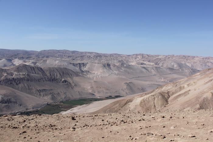
A series of brown hills in the desert.

Volcano deposits, known as ignimbrite, that were incised by the Lluta River in northern Chile. (Image credit: Frances J. Cooper)

The original slope of the volcanic flow from Lauca Caldera was about 1.5 degrees, Adams and his colleagues wrote in the new paper. The researchers also calculated the erosion of the landscape to figure out how fast the rocks in the area were rising as the oceanic Nazca Plate pushed under the continental crust of South America, which is how the Andes were built.

They found that prior to the eruption, the uplift of the crust was no more than 0.16 mile (0.26 kilometer) per million years β€” quite a sluggish process. This finding corresponds to earlier work that used the formation of certain minerals within rocks to determine when a particular rock rose through the crust and approached the surface.

"There is debate over whether the Andes grew slowly and steadily over 40 or 50 million years or whether they rose extremely slowly and then popped up more recently, in the last six to 10 million years," Adams said. "Our findings, which cover a large part of the middle of that history, support the slow but steady hypothesis."

The same method could be applied to other mountain ranges worldwide, the researchers added.

We now have an incredibly detailed map to help predict which areas of LA are the most at risk from 'The Big One'

14 September 2026 at 20:49

Scientists have a new view of the ground under Los Angeles, and it's a bit shaky.

The 3D model of the Los Angeles basin shows that downtown LA is underpinned by up to 6.2 miles (10 kilometers) of sediment, which will likely amplify shaking from any earthquake that hits the region. That's not entirely new information, but the underground map is more precise than ever before, and it should help earthquake scientists better understand which areas of the city are most vulnerable.

"With this improved model of the basin, we now know the shape of the edges of the basin in a lot more detail," Elizabeth Cochran, a U.S. Geological Survey seismologist who was not involved in the study, told Live Science.

That's important, Cochran said, because irregular edges can focus or direct earthquake waves. In the magnitude 6.7 Northridge earthquake in 1994, Santa Monica experienced more shaking damage than expected because of the way the seismic waves traveled along the basin edge, she added.

Los Angeles sits in a sedimentary basin, a low spot where layers of sediment have accumulated for at least 15 million years. At first, the basin was underwater, so the lowest layers of these sediments were oceanic sediments. Later, when tectonic forces brought the basin onto dry land, additional sediment accumulated from the mountains nearby.

Researchers knew the general shape of the basin, but not in great detail. "Previous surveys were just linear arrays that went through just one cross section on the LA Basin, but this was the first full three-dimensional map," said Valeria Villa, a doctoral student at Caltech and co-author of the new paper describing the map, published Aug. 4 in the journal JGR Solid Earth.

A 3D printed model of the LA Basin.

A 3D-printed model of the LA sedimentary basin. (Image credit: Valeria Villa/Caltech)

The data from the new map came from 273 temporary seismic stations deployed around LA. These stations detected faint earthquake waves from distant quakes that couldn't be felt by humans. The paths and timing of these waves as they traveled helped researchers build a 3D map of the rock layers below the surface.

The central part of the basin, under downtown LA, holds the deepest sediments, which could amplify shaking. The edges of the basin are thinner, with 0.6 to 2.5 miles (1 to 4 km) of sediment before the hard crystalline rock that serves as the basin's bottom.

On its own, the map doesn't tell geophysicists exactly where shaking might be the worst in the case of a big LA earthquake, but researchers can now update their models and simulations to test different scenarios, Villa told Live Science. The damage will ultimately depend on a lot of factors, such as which fault causes the quake. Los Angeles is surrounded by many faults, including the famous San Andreas, which could give off a magnitude 7.8 quake that would jolt Southern California.

One important factor in the amount of damage to buildings during such a quake is "resonance" β€ͺ—‬ whether buildings shake in time with the sediments below them, Cochran said. When buildings and sediments are in resonance, the damage is worse. A better understanding of the sediment layers beneath downtown LA will help researchers ensure buildings are designed to avoid resonating with the shaking basin, she said.

"You can, for example, change the stiffness of your building and do other things to offset this effect," Cochran said. "What is important is that you know what the ground is like, and what the larger geologic structure is like, underneath the region where you are building the building to know that this could be an issue."

❌