❌

Normal view

Curiosity Blog, Sols 4968-4974: Rock Climbing Towards the Discontinuity
11 August 2026 at 07:50

3 min read

Curiosity Blog, Sols 4968-4974: Rock Climbing Towards the Discontinuity

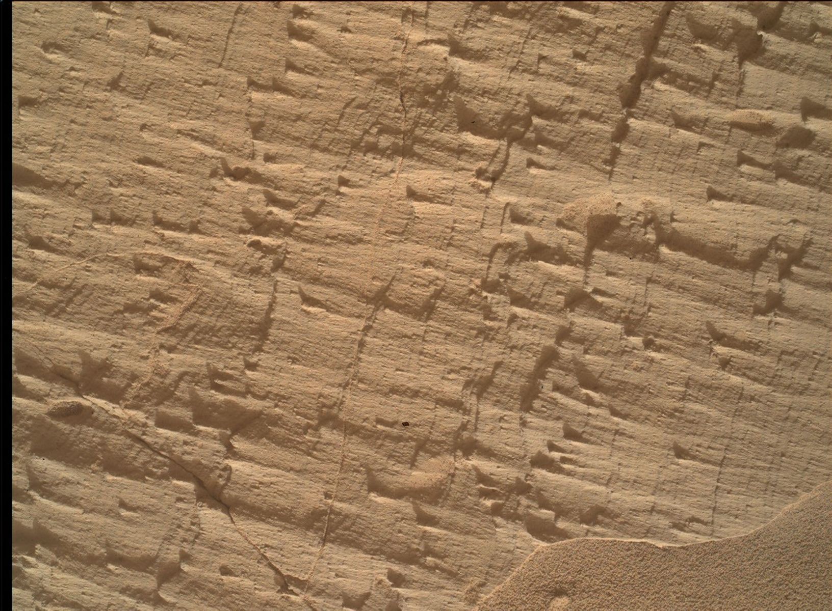
A close-up color photograph taken by the Curiosity rover showing a rough, tan-colored rock surface on Mars. The rock is highly textured, covered in fine parallel layers, small raised ridges, and thin cracks that cast tiny shadows. In the bottom right corner, a small drift of smooth, fine sand rests against the jagged rock.
NASA’s Mars rover Curiosity acquired this image, a frame of the “Longquimay” mosaic showing fine-scale sedimentary textures in a bedrock block near the supersurface, using its Mars Hand Lens Imager (MAHLI), located on the turret at the end of the rover’s robotic arm. Curiosity acquired the image on Aug. 1, 2026 — Sol 4972, or Martian day 4,972 of the Mars Science Laboratory mission — at 23:35:43 UTC.
NASA/JPL-Caltech/MSSS

Written by Lucy Lim, Planetary Scientist at NASA’s Goddard Space Flight Center

Earth planning date: Friday, July 31, 2026

As mentioned in the previous blog, Curiosity has been exploring a large-scale feature in Gale’s sedimentary record suspected to be an “erosional supersurface.” The “supersurface” represents a period in time when a net depositional environment changed to a net erosional one before returning to a depositional regime, thus producing a discontinuity in the rock record. The erosion can involve wind, water, or both. Sometimes there are clues about these environmental changes in the layers below and above the supersurface. So far we’ve been seeing some patterns that look like aeolian features and also some “lens” deposits that sometimes appear consistent with fluvial origins. We need higher-resolution imaging of these features.

This week Curiosity came within detailed imaging range of a section of the “Cerro Paine Grande” vertical exposure just below the candidate supersurface before climbing on top of it. Mastcam was the star of the show on both planning days this week, capturing large stereo mosaics of the vertical face of the outcrop and a 360-degree panorama after the rover climbed on top of it.

A black-and-white photograph taken by the Curiosity rover on Mars. The rover's mechanical arm extends from the left side of the frame toward the center, revealing a complex cluster of scientific instruments at its end. Below the arm, the Martian terrain consists of large, flat slabs of cracked, textured bedrock. The background is filled with scattered, lighter-colored rocks and patches of dark sand with small wind ripples.
NASA’s Mars rover Curiosity acquired this image, showing the rover arm in action in the “Longquimay” workspace at the top of a steep climb. Curiosity captured the image using its Right Navigation Camera on Aug. 2, 2026 — Sol 4972, or Martian day 4,972 of the Mars Science Laboratory mission — at 00:49:52 UTC.
NASA/JPL-Caltech

Roving to the top took full advantage of Curiosity’s climbing capabilities, leaving the rover at an approximate 24-degree tilt in its final parking spot. The rover planners managed to reach the right posture for contact science at the same time — quite a feat, and one that approached the mission’s contact science tilt record of 27 degrees!

Meanwhile, MAHLI and our geochemical instruments provided detailed characterization of the rock layers beneath the discontinuity. I was the Geology and Mineralogy Theme Lead for the Sol 4968 (Monday) planning cycle, during which “Puyehue” in the light-toned bedrock block of the workspace was co-targeted with APXS, MAHLI, and ChemCam LIBS. The other two targeted LIBS observations in the plan went to a similar-looking nearby bedrock block (“Lago Palena”) and an intriguing layered block off to the side of the workspace (“Piedras Juntas”). Another APXS measurement went to a sand target, “Cormudesi,” which will help us assess the consistency of sand compositions along the rover’s traverse.

In the Sol 4972 workspace atop the slope, the bedrock was sharply divided between a smooth bedding-parallel surface on the local top of the outcrop and the darker-toned, rougher, angled exposure of the same rocks. The light-toned top surface was measured by MAHLI, APXS, and the LIBS at target “Sierra de Sangre,” whereas the darker-toned laminated face was targeted by APXS and MAHLI at “Laguna del Laja.” The fine-scale sedimentary structures in the textured material were also documented by a MAHLI mosaic (“Longquimay”) supported by Mastcam M100 imaging.

Rounding out the week’s science observations were several long-distance ChemCam RMI mosaics on more distant targets such as sedimentary structures above the rover’s current stratigraphic position, and finally our regular cadence measurements of the modern Martian environment, including atmospheric opacity and a ChemCam passive-sky survey to monitor abundances of minor atmospheric gases.

A rover sits on the hilly, orange Martian surface beneath a flat grey sky, surrounded by chunks of rock.
NASA’s Curiosity rover at the base of Mount Sharp
NASA/JPL-Caltech/MSSS

Share

Details

Last Updated
Aug 11, 2026

Related Terms

The post Curiosity Blog, Sols 4968-4974: Rock Climbing Towards the Discontinuity appeared first on NASA Science.
What’s Up: August 2026 Skywatching Tips from NASA

31 July 2026 at 23:35

A solar eclipse, the Perseids, bright Venus after sunset, and a deep partial lunar eclipse highlight August’s skywatching.

Skywatching Highlights

  • Aug. 5: Last Quarter Moon
  • Aug. 12: Total solar eclipse across northern Russia, Greenland, Iceland, northern Spain, and part of Portugal; partial eclipse in parts of the U.S.; New Moon
  • Aug. 12-13: Perseid meteor shower peak under dark skies
  • Aug. 14-16: Venus reaches greatest eastern elongation and shines low in the west after sunset
  • Aug. 27-28: Partial lunar eclipse visible from much of North and South America and parts of Europe and Africa

Transcript

A solar eclipse, one of the year’s best meteor showers, Venus at its brightest in the evening sky, and a lunar eclipse to close out the month.

That’s “What’s Up” for August.

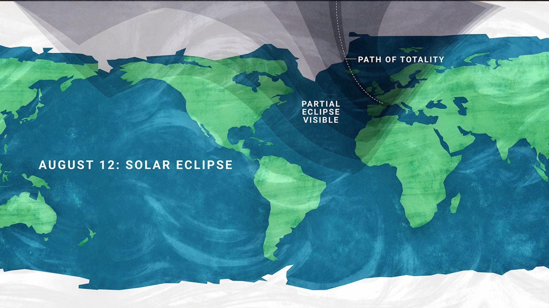
On Aug. 12, a total solar eclipse crosses northern Russia, Greenland, Iceland, and northern Spain, with a small corner of Portugal inside the path of totality.

In parts of the United States, from Alaska to North Carolina, the eclipse is partial. The Moon will take only a small bite out of the Sun, and the amount of coverage will vary with location.

A stylized flat map of the Earth indicating the viewing areas for a solar eclipse, with text on the left reading 'AUGUST 12: SOLAR ECLIPSE'. A semi-transparent dark shadow covers the northern portion of the globe, fanning out from the top edge. Within this shadow, a thin dotted line arcs down from the Arctic, crossing near Greenland and Iceland, passing over the Iberian Peninsula (Spain and Portugal), and ending near the Mediterranean Sea; this line is labeled 'PATH OF TOTALITY'. The broader shaded region surrounding this line is labeled 'PARTIAL ECLIPSE VISIBLE', and it covers northern North America, the Arctic, all of Europe, northern Africa, and northern and western Asia. The unshaded regions covering the rest of the map, including most of the United States, South America, central and southern Africa, and Australia, indicate areas where the eclipse will not be visible.
A map showing viewing areas of the August 2026 total solar eclipse.
NASA/JPL-Caltech

Remember to watch safely. Use certified eclipse glasses or a safe solar viewer any time any part of the Sun is visible. Regular sunglasses are not safe. And never use binoculars, a telescope, or a camera without a solar filter made for the front of the optics.

Later that same night, the Perseid meteor shower will light up the sky, peaking the evening of Aug. 12 into the early morning hours of the 13th. And with a New Moon arriving on the 12th, the skies will be ideally dark.

The Perseids happen every year when Earth passes through a debris stream left behind by Comet Swift-Tuttle. As those tiny bits of comet dust hit our atmosphere at high speed, they burn up as bright streaks of light.

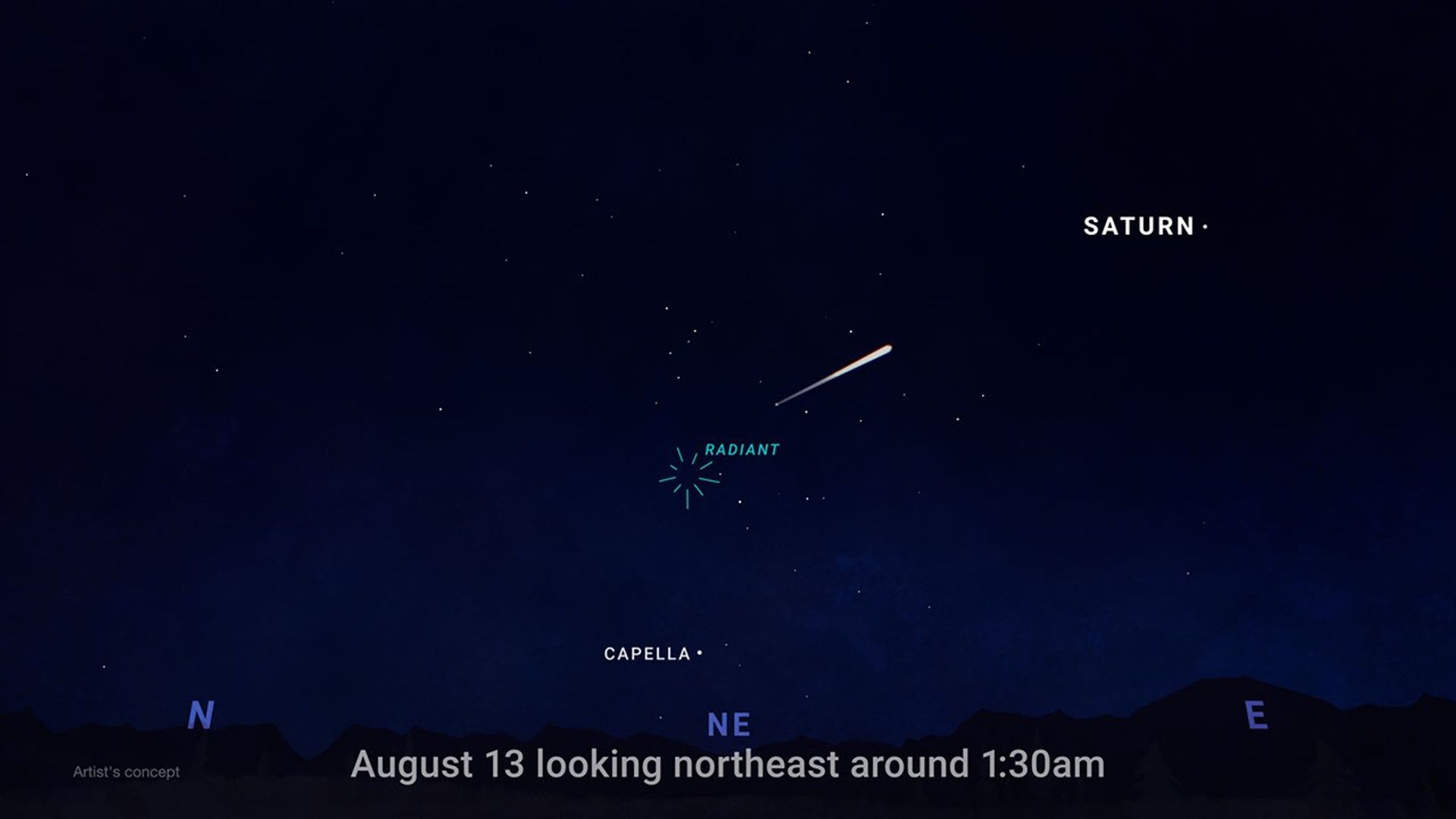
To view this meteor shower, look toward the northeast once it’s fully dark and watch for the constellation Perseus to clear the horizon. This is where the meteors originate, but let your eyes wander, because they can flash across any part of the sky.

For the best view, stay out late as the stars climb higher, find a dark open spot, and give your eyes 30 minutes to adjust.

An illustration of the night sky showing where to look for meteors, with text at the bottom reading 'August 13 looking northeast around 1:30am.' The bottom of the image shows a dark, silhouetted horizon of hills, marked with blue compass directions N (North), NE (Northeast), and E (East). In the center of the sky above NE is a teal burst icon labeled 'RADIANT,' indicating the point from which meteors appear to originate. A bright, white meteor streaks across the dark, starry sky, pointing back toward the radiant. Two other bright celestial objects are labeled: the star 'CAPELLA' is situated low in the sky below the radiant, and the planet 'SATURN' is positioned high up in the upper right corner. Small text in the bottom left corner reads 'Artist's concept.'
This illustration shows where in the night sky to look for the Perseid meteor shower.
NASA/JPL-Caltech

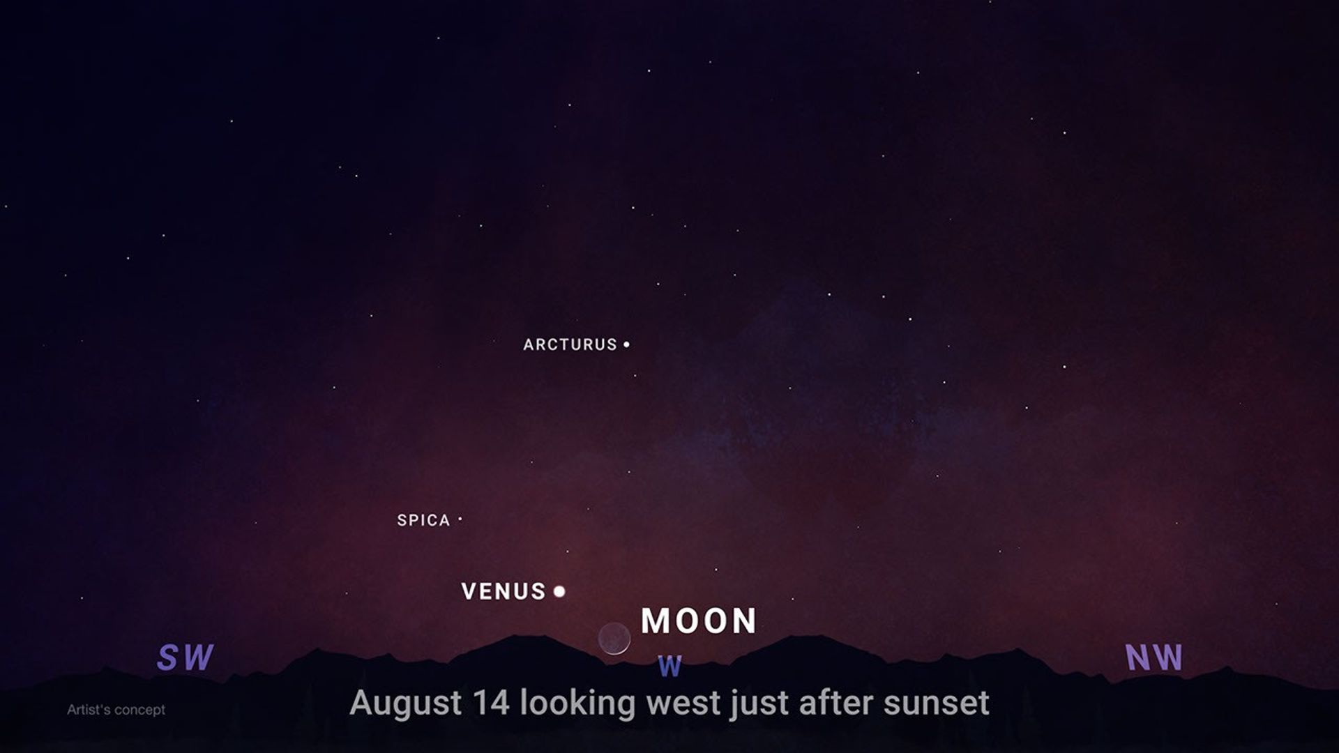
Aug. 14-16, Venus reaches its greatest eastern elongation, which is its widest apparent separation from the Sun during this evening appearance.

Look low in the western sky shortly after sunset for the bright object that will outshine every star around it. Through a telescope after sunset, Venus will look close to half lit, like a tiny lunar phase.

An illustration of the evening sky shortly after sunset, showing the positions of celestial objects. Text at the bottom center reads 'August 14 looking west just after sunset'. The bottom edge features a silhouetted, dark horizon of hills or mountains. Above the horizon, compass directions are indicated in purple: 'SW' (Southwest) on the left, 'W' (West) in the center, and 'NW' (Northwest) on the right. In the center, sitting very low on the horizon, is a faint crescent moon, labeled 'MOON'. Just to the left and slightly above the moon is a bright, white dot labeled 'VENUS'. Higher up and to the left of Venus is a smaller white dot labeled 'SPICA'. Above and to the right of Spica, towards the center of the image, is another labeled star, 'ARCTURUS'. The sky transitions from a deep reddish-purple near the horizon to dark blue at the top, sprinkled with numerous faint stars. In the bottom left corner, small text reads 'Artist's concept.'
This illustration shows where to observe Venus after sunset in August.
NASA/JPL-Caltech

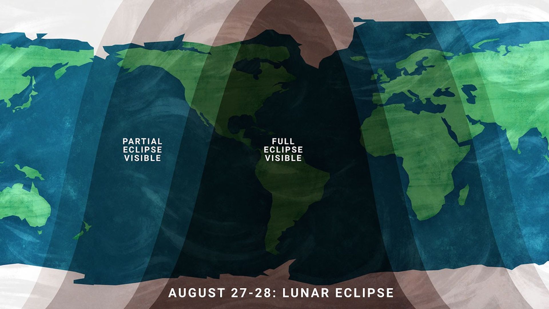
On the night of Aug. 27, continuing into Aug. 28 for some time zones, the Full Moon slips through Earth’s shadow, resulting in a partial lunar eclipse. It will be visible from much of North and South America and parts of Europe and Africa.

A stylized flat map of the Earth indicating the viewing areas for a lunar eclipse, with text at the bottom reading 'AUGUST 27-28: LUNAR ECLIPSE'. Large, semi-transparent dark bands arch across the map to represent visibility zones. The darkest central band, labeled 'FULL ECLIPSE VISIBLE', covers all of North America and South America, as well as the eastern Pacific Ocean and western Atlantic Ocean. Flanking this central region on the left and right are lighter shaded bands labeled 'PARTIAL ECLIPSE VISIBLE'. The western partial eclipse band covers the western Pacific Ocean and New Zealand, while the eastern partial eclipse band covers Europe and Africa. The unshaded outer regions of the map, including most of Asia and Australia, are areas where the eclipse will not be visible.
Viewing areas for the August 2026 lunar eclipse.
NASA/JPL-Caltech

At maximum eclipse, about 93% of the Moon’s diameter will be inside Earth’s dark central shadow, called the umbra. The Moon will not be completely covered, but it can look dramatically darkened, with a rusty, coppery tint along the covered edge.

Unlike a solar eclipse, a lunar eclipse is safe to watch with just your eyes. Binoculars or a small telescope can give you a closer view of Earth’s curved shadow moving across the Moon.

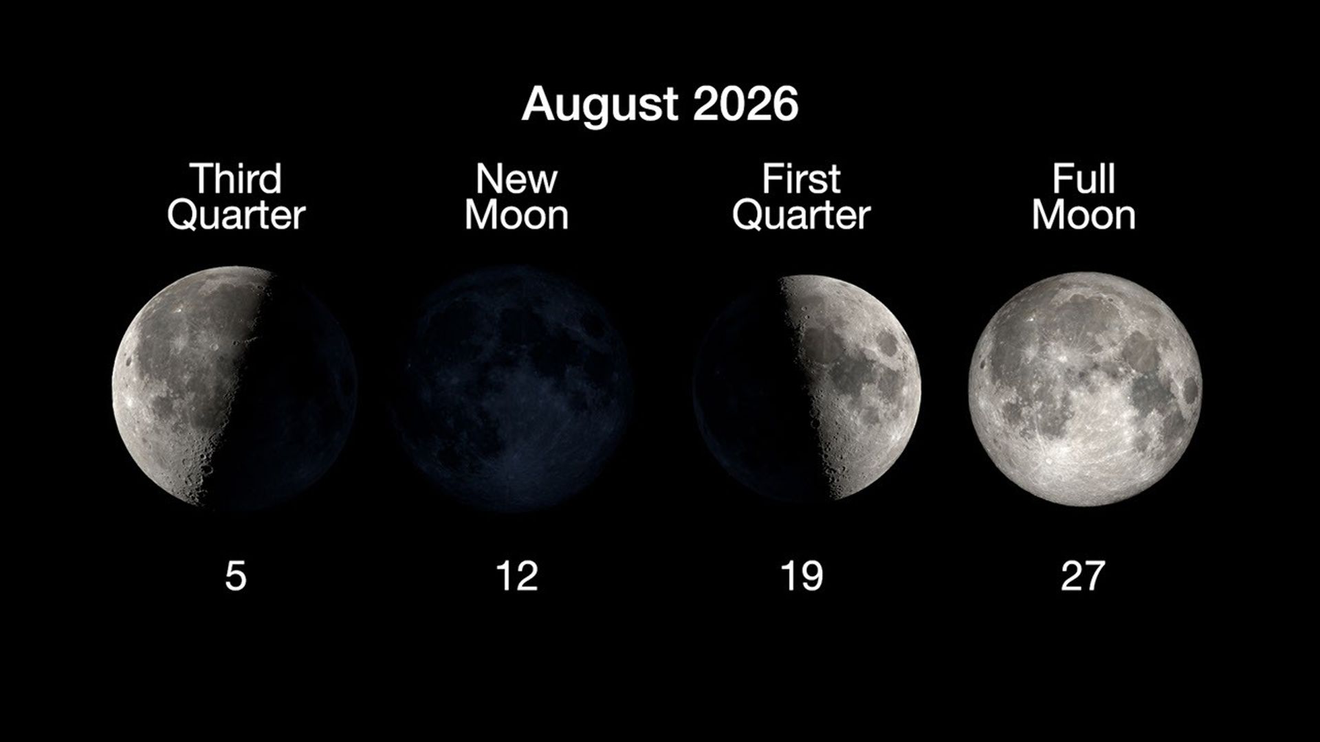
Here are the phases of the Moon for August.

An infographic on a black background titled 'August 2026' showing four primary phases of the Moon arranged in a horizontal row. Each phase features an image of the Moon with text above indicating the phase name and a number below indicating the date in August. From left to right:  'Third Quarter' on the 5th, showing the left half of the Moon illuminated. 'New Moon' on the 12th, showing the Moon's face completely in shadow. 'First Quarter' on the 19th, showing the right half of the Moon illuminated. 'Full Moon' on the 27th, showing the entire face of the Moon illuminated.
NASA/JPL-Caltech

You can stay up to date on all of NASA’s missions exploring the solar system and beyond at science.nasa.gov. I’m Raquel Villanueva from NASA’s Jet Propulsion Laboratory, and that’s What’s Up for this month.

Keep Exploring

Discover More Topics From NASA

The post What’s Up: August 2026 Skywatching Tips from NASA appeared first on NASA Science.

💾

A solar eclipse, one of the year's best meteor showers, Venus at its brightest in the evening sky, and a partial lunar eclipse to close out the month.On Augu...

EAGLE

31 July 2026 at 23:02

EAGLE

Explorer for Artemis Geology, Lunar, and Earth — a NASA satellite program to study surface biology and geology on Earth, with technologies that could support future missions to the Moon and Mars.

Future Mission

NASA’s EAGLE program — Explorer for Artemis Geology, Lunar, and Earth — will be a series of satellite missions studying surface properties using technologies for Earth observation that will also benefit future missions to the Moon and Mars, where they could identify critical resources and safe landing sites.

The satellites making up the first two EAGLE missions will study biology and geology on Earth’s surface to support agriculture, disaster response, and other needs. Each mission will carry a different instrument with capabilities that complement each other. The first mission (EAGLE-VSWIR) is scheduled to take flight in 2028.

Mission Type

Orbiter

Target

Earth, Moon, Mars

Launch

No earlier than 2028

Objective

Study surface composition and changes

  • EAGLE-VSWIR

    EAGLE-VSWIR (Visible to Shortwave Infrared) will observe the Earth’s surface every 16 days with a high-resolution imaging spectrometer, which measures light reflected from the planet’s surface, separating wavelengths across the visual and into the infrared spectrum. The patterns created by light being reflected or absorbed across this spectral range act like fingerprints, letting scientists identify the composition of the surface. 

    A similar instrument, NASA’s EMIT (Earth Surface Mineral Dust Source Investigation), has been monitoring Earth from the International Space Station since July 2022, characterizing the surface mineral composition of Earth’s arid lands, monitoring ecosystem status, and tracking health and safety hazards — such as methane leaks and acid mine drainage — among other applications.

    EAGLE-VSWIR will have 25 times more capability than EMIT has today. This technological leap will allow scientists to map surface deposits of critical and rare-earth minerals, strengthen food security, and aid wildfire prevention and recovery. It can also highlight environmental hazards such as oil spills or landslide risks, and monitor water quality and availability.

    Region of Nevada as observed by NASA's EMIT with spectrum on right edge
    The front of this image cube shows a region in Nevada observed by NASA’s EMIT imaging spectrometer; the cube’s sides show the spectral fingerprint for every point in the image and can be used to discover mineral resources. EAGLE-VSWIR will have 25 times greater performance beyond NASA’s current state-of-the-art EMIT.
    NASA/JPL-Caltech
  • EAGLE-TIR

    The EAGLE-TIR mission will provide Thermal InfraRed (TIR) imagery when it launches two to three years after EAGLE-VSWIR, measuring energy emitted from the surface and producing data that scientists can use to map temperature, composition, and critical mineral deposits. On Earth that would let researchers monitor wildfires and volcanic activity, track drought and water use by crops, study urban heat islands, observe the rates that snow or ice accumulates or melts, and better understand Earth’s resilient ecosystems.

    EAGLE-TIR follows on from ECOSTRESS (ECOsystem Spaceborne Thermal Radiometer Experiment on Space Station), which has been observing Earth from the International Space Station since 2018. ECOSTRESS was designed to study how different ecosystems respond to drought and water stress, and the data has provided a vital understanding of how plants’ water use changes throughout the day. Since ECOSTRESS also measures emitted energy in the thermal infrared, its surface-temperature products have also been used for urban planning and wildfire monitoring. 

    Further innovation and lessons learned from ECOSTRESS has led to EAGLE-TIR, which will carry a multi-band thermal radiometer. EAGLE-TIR’s great strength compared to existing missions is that it provides detailed imagery of the entire globe every two days, day and night, at multiple wavelengths not available from other instruments.

    Aerial view of Namib desert in Infrared captured by ECOSTRESS
    This image shows the minerals contained in Namibian dunes using ECOSTRESS data. EAGLE-TIR will have more spectral channels to enable even better mineral discrimination.
    NASA/JPL-Caltech
  • EAGLE Program

    By advancing vital techniques for measuring our planet’s surface composition, resources, and hazards, the EAGLE program addresses critical needs in Earth observation, with technologies that can also transfer to planetary exploration, where they’ll serve as pathfinders for future missions to the Moon and Mars.

    015B0489.NEF
    As the Artemis II crew came close to passing behind the Moon and experiencing a planned loss of signal, they captured this image of a crescent Earth setting on the Moon’s limb on April 6, 2026.
    NASA
Featured Video

EAGLE

NASA unveiled the EAGLE program as one part of its “Ignition” event on March 24, 2026, when it announced a wide-ranging series of transformative agencywide initiatives. With EAGLE (the Explorer for Artemis Geology, Lunar, and Earth missions), NASA will deploy breakthrough hyperspectral images across Earth with later missions anticipated for the Moon and Mars in rapid succession. On Earth they’ll identify critical minerals for national security, enable precision agriculture, and support disaster response. On Earth and at Mars they will locate critical minerals and resources such as ice for propellants, rare-earth elements for technology, and construction materials for habitats.

EMIT

EMIT (Earth Surface Mineral Dust Source Investigation) measures the mineral composition of Earth’s dust source regions, to help scientists understand how they heat or cool our planet.

Learn More About EMIT

ECOSTRESS

ECOSTRESS (ECOsystem Spaceborne Thermal Radiometer Experiment on Space Station) is accurately measuring the temperature of plants on Earth.

Learn More About ECOSTRESS

The post EAGLE appeared first on NASA Science.

💾

Join us for continuing coverage as our leaders discuss the agency's implementation of the National Space Policy and our plans to advance science and discover...

Curiosity Blog, Sols 4927–4933: Let’s Drive to That Smooth Area

24 June 2026 at 05:34

4 min read

Curiosity Blog, Sols 4927–4933: Let’s Drive to That Smooth Area

A black-and-white landscape photograph of the Martian surface taken by the Curiosity rover. The ground features a heavily textured, polygonal cracked pattern, with light-colored material forming raised veins or ridges along many of the cracks. Several dark, flat rock slabs and smaller loose rocks are scattered across the foreground and middle ground. On the right side of the image, the textured tread marks of the rover's wheels are clearly visible pressed into the soil, curving slightly as they trail off into the distance.
NASA’s Mars rover Curiosity acquired this image showing a breathtaking diversity of polygons, veins, and other textural features waiting for investigation by the Mars Science Laboratory team. Curiosity captured the image using its Left Navigation Camera on June 17, 2026 – Sol 4928, or Martian day 4,928 of the Mars Science Laboratory mission – at 17:47:52 UTC.
NASA/JPL-Caltech

By Susanne P. Schwenzer, Professor of Planetary Mineralogy at The Open University, UK

Earth planning date: Thursday, June 18, 2026

In the area Curiosity is currently exploring, the science team has mapped several areas with different-looking surface texture on the orbital images. If you wanted to have a look yourself at what there is to see, check the “Where is Curiosity?” map. You’ll discover different shades of orange and beige as well as more rough and more smooth-looking textures. This is what the geomorphologists in our team use to map the areas for exploration by the rover. Of course, we then supplement this all with ground-based images, including bespoke “drive direction imaging,” which is taken after each drive by the Mast Camera. Drive planning is done using a combination of all this information. So there shouldn’t be any surprises, right?

On Monday the team planned three sols in preparation for a Thursday planning to account for the U.S. federal holiday weekend. The workspace turned out to be a little spiky, so we could not find an area we could DRT. APXS still found one good bedrock target, “Rio Baker,” which also had MAHLI documentation. In addition, ChemCam investigated “Rica Aventura,” a textured bedrock, and “Tabebuia,” a darker-looking individual block, using its LIBS and conducted a passive spectral observation on a second dark float block called “Lago Ranco.” Of course, the team also wanted to look into the distance with ChemCam remote imaging, extending our investigation of the Cordillera base outcrop.

Imaging is always high on the list. In Monday’s plan Mastcam is looking into the modern dunes with the “Tacaza” mosaic, and with more mosaics looking forward to the future parking areas, some of which looked really smooth from that vantage point. We also continue our environmental and atmospheric observations looking for dust devils, the opacity of the atmosphere, and monitoring pressure and temperature. After all this, the rover drove about 35 meters (about 115 feet) to an area that looked really smooth in all images we had available at that point. So we were hoping for a good spot to deploy the DRT, but didn’t think we could be in for a surprise.

The drive ended exactly as planned, spot-on in the middle of that — from a distance — smooth-looking area. But when we opened the post-drive images on Thursday morning, we were all reacting with a lot of surprise. From up close, the parking spot looks anything but smooth. You can see the surprise in the title image of this blog. There are polygons, veins, lamination, and probably more, once we inspect the higher-resolution images taken today. “Higher-resolution” is the key for why we were in for such a surprise! The features are quite small, a few centimeters across, and therefore we could not see them in the orbital images or from a distance in our navigation and mast camera images. The camera resolution from a distance just isn’t enough to see them. But up close, the terrain revealed all its beauty! And I am sure there will be more in the even higher resolution of today’s MAHLI and ChemCam RMI imager images!

So, what did we plan after we caught our breath on Thursday? First, you guessed it, images, images, and more images. Mastcam takes a full panorama with its “left eye” and adds a range of closer-up mosaics with its higher-resolution “right eye.” In addition there is a ChemCam Remote Micro Imager image to document structures further afield at high resolution. ChemCam is investigating three targets using LIBS: “Rio Chimore” is a lighter-toned band; you can see some of those in the cover image of this blog, too. The other two LIBS targets are “Rio de Lava,” a vein target, and “Rio de Salta,” one of the polygons. APXS is also looking at the bedrock and the ridges, at the targets “Pampa Grande” and “Iquique Ridge.” MAHLI is having the above-mentioned close “hand lens” look. Let’s see what we will discover when we get those images.

Finally, Curiosity drove up the hill along very smooth-looking terrain that is just littered with tiny polygons. Let’s see if we are in for another surprise reverberating around all our offices — and across two continents, as I had the good fortune to be among the first ones, here in England (Or maybe it was our French ChemCam colleagues, who are in a time zone one hour ahead of me?). Whichever it is, this terrain has a lot to say about the geologic history of Mars!

A rover sits on the hilly, orange Martian surface beneath a flat grey sky, surrounded by chunks of rock.
NASA’s Curiosity rover at the base of Mount Sharp
NASA/JPL-Caltech/MSSS

Share

Details

Last Updated
Jun 24, 2026

Related Terms

The post Curiosity Blog, Sols 4927–4933: Let’s Drive to That Smooth Area appeared first on NASA Science.

Curiosity Blog, Sols 4920-4926: Surveying the Bands

19 June 2026 at 01:50

3 min read

Curiosity Blog, Sols 4920-4926: Surveying the Bands

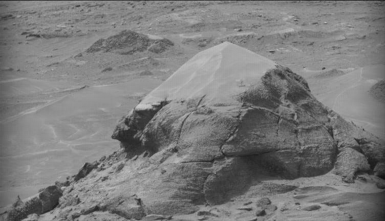
A black-and-white image of a barren Martian landscape featuring a prominent, roughly pyramidal rock outcropping in the foreground. The rock's lower half is rugged with deep cracks and textured layers, while its peak appears lighter and smoother, possibly covered in dust. The surrounding terrain stretches into the background with scattered smaller rocks and another low mound in the distance.
NASA’s Mars rover Curiosity acquired this image of small butte, “Miraflores,” using its Mast Camera (Mastcam) on June 11, 2026 — Sol 4922, or Martian day 4,922 of the Mars Science Laboratory mission — at 09:12:13 UTC.
NASA/JPL-Caltech/MSSS

Written by William Farrand, Senior Research Scientist, Space Science Institute

Earth planning date: Friday, June 12, 2026

Rather than going from stage to stage at a music festival to hear different bands playing different varieties of music, Curiosity has been ascending up Mount Sharp through physical bands of exposed rocks with textural and tonal differences.

Planning for sols 4920 and 4921 were done with the rover in the middle of a unit with a rougher texture and dark-toned bedrock. With the rougher-textured bedrock, brushing wasn’t possible, but APXS chemistry and MAHLI micro-imaging were planned on “as is” bedrock targets “Salto La Cascada” and “Puerto de Rosas.” ChemCam was targeted to perform LIBS spectroscopy on a bedrock target “Kishuara” and a small, layered float rock “La Rosita.” ChemCam’s Remote Micro-Imager (RMI) collected views of the “Mishe Mokwa” butte and another looking at dunes with tonal differences. Mastcam mosaics were collected on the “Valle Grande” channel, “Kimsa Chata” butte, nearby troughs, and the aircraft carrier shaped rock “El Matir.”

Another drive brought Curiosity closer to the upper border of the dark-toned band. Again, brushing of the rocks was not possible, but APXS and MAHLI were collected on dark-toned bedrock targets “Santa Gracia” and “Laguna San Rafael” with ChemCam LIBS also targeting the bedrock. Mastcam mosaics were collected of a layered rock and nearby troughs and a mosaic of the nearby smaller butte, “Miraflores” which displays an interesting layered structure with ragged dark-toned rocks on one side and a stack of dust piled on top (see accompanying image). Other activities included a long-distance RMI mosaic of a bright unit on “Mishe Mokwa”, and Navcam dust-devil surveys in both sols.

Communicating between Earth and Mars has come to seem routine, but at times can still be a challenging endeavor and this was demonstrated to the team on Friday when we did not get a timely downlink of data for the drive planned for Sol 4923. Without these images another drive, in situ examinations, or targeted remote sensing could not be planned. However, there are always interesting things to be done on Mars and the three-sol plan (4924 to 4926) included a 360-degree Mastcam mosaic, the automatic AEGIS targeting of LIBS measurements on each sol, a Navcam dust-devil survey, APXS atmospheric measurements, as well as several other environmental activities.

On Monday, the delayed downlink will be used to plan the first investigation of the next band of surface materials, this one being smooth-textured and light-toned, as well as another drive to continue the surveying of the bands.

A rover sits on the hilly, orange Martian surface beneath a flat grey sky, surrounded by chunks of rock.
NASA’s Curiosity rover at the base of Mount Sharp
NASA/JPL-Caltech/MSSS

Share

Details

Last Updated
Jun 18, 2026

Related Terms

The post Curiosity Blog, Sols 4920-4926: Surveying the Bands appeared first on NASA Science.

Eyes on Exoplanets Tutorial

12 June 2026 at 00:20

Eyes on Exoplanets Tutorial

Video tutorial showing how to use NASA’s 3D interactive tool “Eyes on Exoplanets.”
NASA/JPL-Caltech

Welcome to NASA’s Eyes on Exoplanets! Use this tutorial to start exploring worlds beyond our own. With this 3D interactive tool, you can visit all the stars beyond the Sun where we’ve found other planets, called exoplanets. 

Choose a star or exoplanet and see an artist’s concept of what it might look like. Spin it around to see its sun and planetary system. Learn how long a trip there from Earth would take at light speed — or by jet plane, or family car!

Study the real versions of planets and stars cited in your favorite science fiction. See which planets reside in habitable zones, where liquid water could exist on their surfaces. Or, search “Where We Explore,” stars that future space telescopes will target when looking for Earth-like planets. You can also choose your location on Earth and see what’s in the sky above you right now.

Select any of the stars shown to see how many planets have already been found there. Examine how those star systems compare to the layout of our solar system, or check the sizes of individual planets — are they as small as Earth, or as big as Jupiter? 

See all the different techniques we’ve used to confirm the 6,000+ exoplanets discovered so far — among the billions we believe exist in the galaxy — and the many observatories, on Earth and in space, that have detected them. You can also browse some of our favorite weird worlds, or destinations featured in our Exoplanet Travel Bureau.

Where will you explore?

Transcript

Welcome to NASA’s Eyes on Exoplanets. With this interactive tool, you can explore all of the stars beyond the Sun where we’ve discovered planets known as exoplanets. When you enter the site, the default is this view from space. You can start your exploration here. Or if you know of a specific star or exoplanet you want to visit, enter that in the search bar at upper right. 

You can also select View from Earth. Choose your location and see what’s in the sky above you right now. Click and drag to explore different parts of the sky. In the lower right corner, you can choose different display options. You can see the constellations, view only stars that are visible to the naked eye, or see the stars that are good places for future telescopes to search for planets like Earth. 

These future target stars are shown as filled-in circles. If you click the gear symbol and switch from the star symbol to the circled number, you will see how many exoplanets have already been found around the star shown. 

When you select a star, you have three different view options. Starting in System View, you will see the star and where planets are located around it. The shaded green area marks the habitable zone, the region around a star where a planet could have liquid water on the surface, a key to the search for life beyond Earth. You can also see how this system compares to our solar system by selecting that feature in the lower right. The star view will show a hypothetical view of what the star might look like. 

Click “Learn More” to see basic information about the star, including its history and pop-culture references. You can see how it compares to our Sun and solar system and what we found so far. Under “How to Detect a Planet in the System,” you can learn about the different ways to discover an exoplanet and see how many planets have been found with each technique, as well as the prospects for discovering more. Finally, the planet view allows you to explore each planet in the system. 

For each confirmed exoplanet, you’ll see an artist’s concept of what it might look like and see how it compares to other planets. Planets also have an option to learn more, where you can see how far away it is, how long it would take to get there, how it was discovered, and which observatory found it. 

To see other discoveries made by that observatory, click “Browse Destinations” in the upper right menu. There you can also find curated lists of featured discoveries and truly weird worlds. 

As you can see, there are so many worlds to discover. Where will you explore?

The post Eyes on Exoplanets Tutorial appeared first on NASA Science.

❌