Reading view

Sequoia and redwood trees alive today were already mature when the Roman Empire was at its peak — the oldest living giant sequoias are over 3,000 years old, which means they were standing in California before the Parthenon was built in Athens, before Julius Caesar was born, and before the Roman Empire even existed

In Sequoia National Park in California, a giant sequoia named the President stands 247 feet tall, carries roughly 2 billion leaves, and has been alive for about 3,200 years. It germinated as a small seed in the late twelfth century BC. At the time, the New Kingdom of Egypt was building additions to the temples at Karnak. The Trojan War, if it actually happened, was still within living memory. The first Olympic Games would not be held for another four centuries. The founding of Rome, in the traditional reckoning, would not occur for another 425 years. The Parthenon would not be built for another seven centuries. Most of recorded human history is younger than the President tree.

The President is not even the oldest known giant sequoia. According to a National Park Service history of sequoia age estimates, the Grizzly Giant in Yosemite’s Mariposa Grove was estimated at 3,800 years of age by early 20th-century researchers, and was considered by many to be the oldest of all living giant sequoias. Other historic estimates pushed individual trees as old as 4,000 years. The most carefully verified figures, based on ring counts of stumps in the early 20th century, identified a small number of giant sequoias more than 3,000 years old, with the oldest at about 3,200 years.

Why sequoias live so long

The biological mechanism behind sequoia longevity is a combination of features that together produce an organism unusually resistant to the ordinary causes of tree death. The bark of a mature giant sequoia is up to three feet thick, fibrous, and rich in tannins that deter insects and fungi. The wood itself contains compounds that resist decay, so even fallen sequoia logs remain intact for centuries. The trees are notably fire-adapted: their thick bark insulates the living cambium beneath, and surface fires that would kill most species sweep through a sequoia grove without ending the trees’ lives. In fact, periodic fires are required for sequoia reproduction. Sequoia cones release their seeds in response to the heat of a passing fire, exposing the freshly cleared mineral soil that seedlings need.

The biggest threat to a mature giant sequoia is not age but mechanical failure. The trees grow so large that root systems eventually become unable to anchor them against high winds, particularly in saturated soil after heavy storms. Most sequoias that die in old age do so by falling over rather than by senescence in any biological sense. There is no indication that giant sequoias have a maximum natural lifespan in the way most species do. They simply continue to grow, slowly, for as long as they remain upright. According to Atlas Obscura’s profile of the General Sherman tree, the largest sequoia by volume is “adding volume faster than ever, overturning previous theories that trees grow more slowly as they get bigger.”

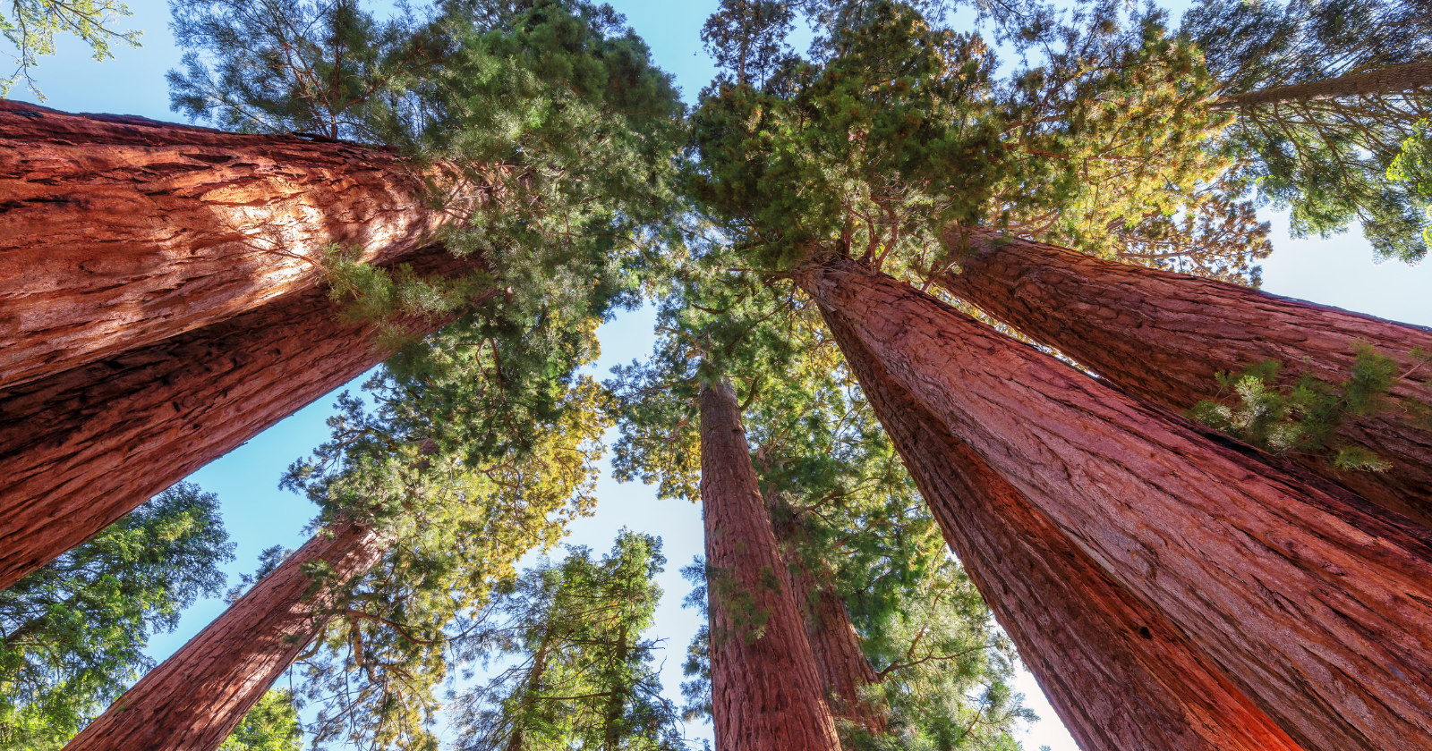
Two species, often confused

The popular phrase “sequoia and redwood” conflates two distinct species. The giant sequoia (Sequoiadendron giganteum), confined to about 75 groves on the western slope of the Sierra Nevada in California, is the species producing the famous 3,000-year-old specimens. The coast redwood (Sequoia sempervirens), found along the Pacific coast from southern Oregon to central California, is a closely related but separate species. Coast redwoods are the tallest trees on Earth, with the current record-holder, Hyperion, measuring 380 feet, but they typically do not live as long as giant sequoias. The oldest documented coast redwoods are around 2,200 years old. The world’s oldest individual tree of any kind is neither a sequoia nor a redwood, but a bristlecone pine (Pinus longaeva) named Methuselah, growing in California’s White Mountains, with a verified age of approximately 4,855 years.

What makes the giant sequoias famous is the combination of their longevity with their sheer mass. The General Sherman tree, the largest single-stem tree in the world by volume, contains roughly 1,487 cubic metres of wood and weighs over 2,000 tons. The National Park Service’s current age estimate places it at about 2,200 years, with other published figures ranging from 2,200 to 2,700 years depending on the dating method. Earlier 20th-century estimates were considerably higher, reaching 3,500 years or more, but successive scientific revisions have brought the figure down. The uncertainty reflects the practical difficulty of dating a living tree without coring it deeply enough to count its innermost rings, which for the oldest sequoias would require boring through metres of dense, often partially-rotten heartwood.

What 3,200 years actually looks like

The historical context becomes more striking the more carefully you spell it out. A tree that germinated in 1,175 BC was already a sapling when the Phoenician alphabet was being developed. It was approximately 425 years old when Rome was founded in 753 BC by the traditional reckoning. It was approximately 728 years old when work began on the Parthenon in 447 BC. It was approximately 1,075 years old when Julius Caesar was born in 100 BC. It was approximately 1,200 years old when the Roman Empire was founded under Augustus in 27 BC. It was approximately 1,290 years old when the Roman Empire reached its territorial peak under Trajan around 117 AD.

The tree was already ancient by every meaningful measure when the Western Roman Empire fell in 476 AD. It had been alive for 2,460 years when the Norman Conquest of England occurred in 1066. It had been alive for 2,975 years when the United States declared independence in 1776. It has now lived through the entire span of recorded human history of California’s indigenous Yokuts, Tubatulabal, and Mono peoples, who lived in proximity to the giant sequoia groves for the last several thousand years and who, by oral tradition, regarded the trees with religious significance. The first widely-documented European sighting of a giant sequoia, by Augustus T. Dowd, occurred only in 1852. From the tree’s perspective, that encounter happened less than 6 percent of its life ago.

The General Sherman, the President, the Grizzly Giant, and the other named individuals of the giant sequoia groves are quietly older than nearly every cultural reference humans use to anchor the deep past. They were there when those reference points happened. They are still there now.

The post Sequoia and redwood trees alive today were already mature when the Roman Empire was at its peak — the oldest living giant sequoias are over 3,000 years old, which means they were standing in California before the Parthenon was built in Athens, before Julius Caesar was born, and before the Roman Empire even existed appeared first on Space Daily.

  •  

Zealandia, the submerged continent geologists confirmed in 2017, is 94 percent underwater and stretches nearly two million square miles beneath the South Pacific, yet its modern name was quietly proposed by geophysicist Bruce Luyendyk in 1995

Close-up of a vintage map showing the Indian Ocean with detailed geographic features.

The Interislander ferry between Wellington and Picton carries tourists, freight trucks, and commuters across a stretch of the Cook Strait most of them assume is just water between two New Zealand islands. It is not. The cliffs on either side are the exposed peaks of a continent, and the three-hour crossing passes over a shallow gap in a landmass nearly the size of the Indian subcontinent. Almost no one on board knows they are crossing it. For most of human history, no one knew it existed at all.

Zealandia, as geologists now call it, covers about 4.9 million square kilometres (1.9 million square miles) of the South Pacific. Roughly 94 to 95 percent of it sits below sea level, in places under a kilometre or more of water. New Zealand’s North and South Islands, plus New Caledonia and a scattering of seabird-covered rocks, are the only parts that breach the surface. Everything else, including the Lord Howe Rise, the Challenger Plateau, the Campbell Plateau, and the Chatham Rise, is the drowned body of a continent that broke off Gondwana around 80 million years ago and slowly sank.

The strange thing about Zealandia is not that it is underwater. It is how long it took the people who study Earth’s crust to call it what it is.

A name, and then two decades of silence

Bruce Luyendyk, a geophysicist at the University of California Santa Barbara with deep ties to New Zealand’s scientific community, proposed the name in 1995. He was not arguing that the region qualified as a full geological continent. He was pointing out that the rocks beneath the waves were clearly built from the same ancient slab and needed a single label. The continental crust under New Zealand did not stop at the country’s shoreline. It extended outward across the surrounding ridges in the shape of a long, drowned wing.

The name stuck within a small circle of marine geologists. Outside that circle it went nowhere. Continents, in the public imagination, are the seven you learn in primary school. Adding an eighth, mostly underwater and visible only as a pair of islands and a few rocks, was not the kind of revision that travelled fast.

It took twenty-two years for someone to make the bigger claim.

The moment it became a continent

In 2017, GNS Science geologist Nick Mortimer and ten coauthors published the case in GSA Today, the journal of the Geological Society of America. Their argument was procedural rather than dramatic, which was part of the point. Geologists already had four working criteria for what makes a continent: elevation above the surrounding ocean floor, a distinctive range of igneous, metamorphic, and sedimentary rocks, thicker crust than the abyssal basins around it, and well-defined limits over a large enough area to count as more than a microcontinent. Zealandia, the team showed, satisfied all four.

The crust beneath it runs 10 to 30 kilometres thick, against roughly 7 for the oceanic crust around it. The submerged plateau sits one to two kilometres higher than the surrounding seafloor. The rocks dredged from its ridges are granite, schist, and sandstone, the standard continental assemblage. The boundaries enclose a coherent block about the size of the Indian subcontinent.

Calling it a continent was not, in their phrasing, a sudden discovery. It was the recognition of something that had been mapped piece by piece for half a century. The Mortimer paper credited Luyendyk explicitly. The name introduced in 1995 became the natural label for the continent they were now formally describing.

Explore the deep blue underwater world with bubbles, rope, and ambient light.

How a continent goes underwater

Zealandia’s submersion is a story of stretching. Around 105 million years ago, the eastern edge of Gondwana, the southern supercontinent that once included Australia, Antarctica, South America, India, and the future Zealandia, began to pull apart. A 2025 reconstruction by Luca Dal Zilio and colleagues described the rifting as a flood of fire, with massive volcanic activity accompanying the tear.

As the crust stretched, it thinned. Thinner crust sits lower. By 80 million years ago, Zealandia had fully separated, and its surface, once mountainous and forested, began to sink. By around 23 million years ago, most of it lay underwater. Whether any part of it stayed continuously above the waves is still debated, and the answer matters: it determines whether the tuatara, the kiwi, and the kauri trees of northern New Zealand are the survivors of a continuous lineage that rode Zealandia down, or later arrivals that dispersed across the ocean to a re-emerged island.

Mapping the invisible

Most of what is now known about Zealandia’s shape comes from bathymetry, the underwater equivalent of topography, gathered over decades of ship surveys and satellite passes. GNS Science and collaborators have since released what they described as the first complete map of the continent, revealing the geology of the northern two-thirds in detail that had not existed before, including a long-suspected belt of subduction-zone rocks running through the submerged interior. Modern bathymetric surveys now combine lidar, sonar, and uncrewed surface vehicles to chart depths that, for most of human history, were measured with a lead weight on a rope.

Each survey added a few percent more detail. The continent did not appear in any single moment. It accumulated, the way scientific consensus usually does, by the slow piling up of data until a name proposed in 1995 by one geophysicist became unavoidable to eleven of his successors.

Stunning rocky coastal formations with waves crashing against them on a sunny day.

What recognition looks like

The 22-year gap between Luyendyk’s suggestion and Mortimer’s confirmation is itself a small lesson in how earth science works. Continents are not discovered the way islands are. There is no moment when a sail crests a horizon. There is only the accumulation of soundings, dredge samples, gravity readings, and sediment cores, until the shape of something becomes impossible to deny. The 2017 paper did not find Zealandia. It declared, on behalf of a discipline that had been quietly mapping the thing for fifty years, that the evidence was now sufficient.

Even so, school maps and atlases have not caught up. As one summary of the discovery put it, the landmass is Earth’s missing eighth continent, hiding in plain sight under a relatively shallow stretch of the Pacific.

From the deck of the Interislander, the cliffs on either side are not the edge of an island chain. They are the exposed peaks of a continent confirmed by eleven scientists in 2017, named by one in 1995, and mapped in full only a few years ago. The South Island’s Southern Alps, rising above 3,700 metres at Aoraki Mount Cook, are the highest point of a landmass whose average elevation is more than a kilometre below sea level. Below the hull, the rest of it stretches for nearly two thousand kilometres in every direction, dark and granite and, until very recently, nameless.

The post Zealandia, the submerged continent geologists confirmed in 2017, is 94 percent underwater and stretches nearly two million square miles beneath the South Pacific, yet its modern name was quietly proposed by geophysicist Bruce Luyendyk in 1995 appeared first on Space Daily.

  •  

New Zealand and New Caledonia are the only large fragments of Zealandia still poking above the ocean, meaning the country most travellers think of as a pair of islands is actually the exposed mountain peaks of a continent five times their size.

Stunning aerial view of Wellington's urban landscape and waterfront on a sunny day with clouds.

Stand on Piha Beach west of Auckland at low tide. The black sand stretches toward the Tasman, the surf rolls in, and the horizon looks like the edge of the world. It isn’t. The continent you are standing on extends roughly 2,000 kilometres in nearly every direction beneath the waves, five times larger than the country shown on any map you have ever seen. New Zealand is not a pair of islands. It is the exposed summit ridge of a drowned continent called Zealandia, and the reclassification of that submerged landmass is quietly rewriting how scientists, lawyers, and cartographers understand the South Pacific.

Geologist Nick Mortimer and his colleagues at GNS Science, Victoria University of Wellington, the Geological Survey of New Caledonia, and the University of Sydney published the formal case in GSA Today in February 2017, arguing that the landmass beneath New Zealand and New Caledonia meets every geological test for continental status. The name itself was not new. It had first been proposed by geophysicist Bruce Luyendyk in 1995, and Mortimer’s team used the 2017 paper to show why Zealandia should be treated not as a scattering of fragments, but as a coherent continent. It covers about 4.9 million square kilometres, roughly two-thirds the size of Australia, and about 94 percent of it sits underwater. New Zealand’s North and South Islands, together with New Caledonia far to the north, are the only large fragments still breaking the surface of the Pacific.

The continent hiding in plain sight

Mortimer’s team did not discover Zealandia in the sense of stumbling on something unknown. Bathymetric maps had shown the broad, shallow plateau around New Zealand for decades. What the 2017 paper did was apply the four criteria geologists commonly use to define a continent: high elevation relative to oceanic crust, a distinct range of rock types, thicker crust than the surrounding ocean floor, and clearly defined boundaries across a large enough area.

Zealandia passed all four. The crust beneath the Tasman Sea and the Pacific around New Zealand runs between 10 and 30 kilometres thick, against about 7 kilometres for normal oceanic crust and roughly 30 to 46 kilometres for the continental crust of Australia or North America. Zealandia sits at the thinner, stretched end of the continental range, which is why most of it sank, but it is still continental rock, including granite, schist, greywacke, and sandstone, not simply the basalt of an ocean floor.

Bathymetric map showing the submerged continent of Zealandia beneath New Zealand and New Caledonia.

The scale is hard to absorb. New Zealand’s land area is about 268,000 square kilometres. New Caledonia adds another 18,500. The continent itself spans close to five million square kilometres, which makes the visible portion only a small fraction of the whole. The Chatham Rise east of the South Island, the Campbell Plateau to the south, the Lord Howe Rise stretching toward Australia, and the Norfolk Ridge running up to New Caledonia are all parts of the same broad block of continental crust. The ocean is shallower over them because the rock beneath is lighter, granite-rich, and stands higher than the surrounding seafloor.

How a continent drowns

Zealandia broke away from Gondwana between roughly 85 and 60 million years ago, pulling apart from what is now Antarctica and Australia. The rifting stretched the continental crust like warm toffee, thinning it from a standard continental thickness toward the 10-to-30-kilometre range measured across much of Zealandia today. Thinner crust floats lower on the mantle beneath it. Over tens of millions of years, most of Zealandia subsided below sea level.

The North and South Islands of New Zealand exist because they sit on the boundary between the Pacific and Australian tectonic plates. The collision there has been crumpling and uplifting rock for the past 25 million years, building the Southern Alps and the volcanic spine of the North Island faster than erosion can wear them down. New Caledonia survived above water for related tectonic reasons, riding a separate piece of crust that was pushed up during the same broad period of deformation.

Everywhere else on the continent, the slow sinking won. The Challenger Plateau, the Hikurangi Plateau, and the Bounty Trough are all Zealandian terrain that lost the race against subsidence.

The ship that mapped the underside

In 2017, the International Ocean Discovery Program sent the drillship JOIDES Resolution across northern Zealandia to take core samples from six sites in the Tasman Sea. The expedition recovered more than 2,500 metres of sediment and volcanic rock, giving scientists a deeper record of how the drowned continent moved, rose, sank, and changed through the Paleogene.

Those cores helped show that parts of northern Zealandia had shifted vertically by kilometres. Some areas that are now deep underwater were once much shallower, and the recovered sediments gave researchers new evidence for reconstructing Zealandia’s changing geography through time.

Then, in 2023, GNS Science reported that Zealandia had become the first ever continent to have its geology, volcanoes, and sedimentary basins mapped out to its underwater edges. The map identifies volcanic regions, sedimentary basins, and a 4,000-kilometre granite backbone running through the continent, a topography as varied as any continent above water, just submerged.

A serene beach scene with trees, turquoise water, and distant mountains, perfect for relaxation.

What New Caledonia is, geologically

New Caledonia is often described as a Pacific island, lumped together with Fiji, Vanuatu, and the Solomons. Geologically, it has almost nothing in common with them. Vanuatu and the Solomons are young volcanic island arcs, built by subduction on oceanic crust. New Caledonia is an exposed fragment of ancient continental terrain at the northern end of Zealandia, with basement rocks that trace back to Gondwana.

The island’s famous nickel deposits, which have shaped its political and economic life for more than a century, sit in ultramafic rocks associated with an ophiolite: a slice of mantle and oceanic crust thrust on top of older continental basement during a tectonic squeeze. That is what makes New Caledonia so geologically strange. In one place, it preserves both a drowned continent and a piece of ocean floor pushed onto it.

Why “eighth continent” is more than branding

Whether Zealandia counts as a continent depends on who is counting. Geographers traditionally name seven, and that list is taught from primary school onward. Geologists, who care about crustal composition and structure rather than coastlines, increasingly accept eight. The distinction matters because it changes how the region is studied, funded, and understood.

It also overlaps with law and resource management, although not as simply as a slogan about an “eighth continent” might suggest. Under the United Nations Convention on the Law of the Sea, continental shelf claims depend on technical evidence about the seafloor and the outer edge of the continental margin. New Zealand made a submission to the UN Commission on the Limits of the Continental Shelf in 2006 for areas beyond 200 nautical miles, years before Zealandia became a popular headline. The later geological framing gives the public a clearer language for the same underlying reality: much of the seafloor around New Zealand is not abyssal wilderness, but part of a continent’s submerged edge.

The classification also reframes the entire South Pacific. The region looks empty on a standard map, a vast blue space dotted with small islands. The bathymetric map looks completely different. A continent the size of the Indian subcontinent stretches across it, with New Zealand and New Caledonia as the only substantial peaks.

Living on a summit

For a New Zealander or a New Caledonian, the implications are quiet but persistent. The country’s mountains, Aoraki / Mount Cook at 3,724 metres, the volcanic peaks of the North Island, and the chain of New Caledonia’s central range are not isolated highlands rising out of an ocean. They are the highest points of a continental landscape that continues, smoothly and continuously, downward and outward beneath the sea.

Earthquakes in the region are largely the consequence of Zealandia’s slow tectonic argument with the Pacific Plate. The same forces that keep the North and South Islands above water also produce the country’s frequent seismic activity. The land is geologically alive because it is being held up against gravity by ongoing collision.

The fish stocks, seabird colonies, and marine life around New Zealand and New Caledonia also depend on the unusual bathymetry of the continent beneath them. Shallow continental shelves help create nutrient-rich waters and productive ecosystems that ordinary deep-ocean island groups cannot support. The reason the surrounding seas teem with life is connected to the same reason the islands themselves exist: a continent sits just beneath the surface.

The map you grew up with

School atlases still show seven continents and a scatter of Pacific islands. Most globes give Zealandia no acknowledgement. The continent is invisible at the resolution of standard cartography because it is, on average, more than a kilometre underwater.

If sea levels were lower by 2,000 metres, the world map would look strikingly different. A landmass larger than India would appear in the South Pacific, with the present North and South Islands as a narrow mountain range running up its eastern side and New Caledonia as a northern extension. Australia would have a continental neighbour, separated by a shallow sea rather than the deep Tasman.

The water is the only reason that map is not the familiar one. Underneath, the continent is already there, already mapped, already named, with New Zealand and New Caledonia standing on top of it the way a climber stands on the last few metres of a much taller peak.

The post New Zealand and New Caledonia are the only large fragments of Zealandia still poking above the ocean, meaning the country most travellers think of as a pair of islands is actually the exposed mountain peaks of a continent five times their size. appeared first on Space Daily.

  •  

A team led by Nick Mortimer at GNS Science in New Zealand spent two decades mapping the basalt and granite floor of the Tasman region before formally naming Zealandia in a 2017 paper, ending more than a century of arguments about whether a submerged landmass could still count as a continent.

Explore the vibrant underwater world with coral reefs and fish under sunlight in clear ocean waters.

For more than a century, schoolchildren have learned that Earth has seven continents, and for more than a century that count has been wrong. Not because anyone miscounted the dry land, but because the working definition of “continent” quietly assumed a continent had to be mostly above water. When a team led by geologist Nick Mortimer at GNS Science in Lower Hutt, New Zealand, finally went public in 2017 with a paper formally naming Zealandia, a continent of roughly 4.9 million square kilometres lying 95 percent underwater, the real argument was not about a new piece of land. It was about whether scientific definitions can survive contact with evidence that doesn’t fit them.

The claim was not that Mortimer’s team had discovered new land. The claim was that the rock under the Tasman Sea was the wrong kind of rock to be ocean floor, and that the only thing keeping it off the list of continents was an unwritten rule about being dry.

What a continent actually is

To a geologist, a continent is not defined by being dry. It is defined by being made of thick, buoyant, silica-rich crust, the kind that rides high on the mantle because granite is lighter than basalt. Ocean floor is thin and dense and dark. Continental crust is thick, pale, and old.

Mortimer’s team set out four tests a chunk of Earth has to pass to qualify: elevation above the surrounding ocean floor, a distinct geology of continental rocks, thicker crust than the seabed around it, and well-defined limits over a large enough area to count as more than a fragment.

Zealandia, they argued, passes all four. The trouble is that a fifth test had always been hiding in the background: most people assumed a continent had to be mostly dry. There was no scientific reason for that assumption. It was just convention, and the question Mortimer’s paper forced was whether convention should outweigh the rock.

Two decades of dredging

The evidence that broke the convention was accumulated slowly, expensively, and unglamorously. Research vessels lowered steel buckets onto undersea ridges and plateaus and hauled up whatever broke off. Mortimer’s team and collaborators pulled granite samples from the Lord Howe Rise, sandstone with fossilised pollen from the Challenger Plateau, and Cretaceous basalts from the Campbell Plateau south of New Zealand.

None of that material belonged on an ocean floor. Granite forms inside continents, where heat and pressure cook silica-rich magma in deep chambers over millions of years. Finding it sitting more than a kilometre below sea level, hundreds of kilometres from any coast, is like finding a redwood stump on the floor of an empty swimming pool.

The team also used satellite gravity data and seismic profiles to measure crustal thickness. Oceanic crust runs about 7 kilometres thick. Zealandia’s crust came in between 10 and 30 kilometres, thinned by stretching but unambiguously continental. Each line of evidence on its own could be argued with. Together, they made the existing definition of continent harder to defend than the new boundary on the map.

From above of fit anonymous diver in flippers with oxygen cylinder on back exploring blue ocean water with bubbles during vacation

How a continent ends up underwater

About 105 million years ago, Zealandia was part of the eastern edge of Gondwana, attached to what is now Australia and Antarctica. Then it broke off. As the rift between it and Australia widened into the Tasman Sea, the crust stretched and thinned, the way pulled taffy goes pale and flat. Thinned crust sits lower. Lower crust ends up underwater.

By around 80 million years ago, Zealandia was a separate continental ribbon, gradually subsiding as it cooled and rode away on its own tectonic plate. Most of it sank below sea level by the late Eocene. Only the bits riding the boundary between the Pacific and Australian plates, including the islands now called New Zealand, got pushed back up by collision and stayed in the air.

Nature’s geodynamics summary describes Zealandia as a continental fragment rifted from East Gondwana during the Cretaceous, with its current shape controlled by successive phases of extension and magmatism. In plain terms: it was stretched, thinned, and then drowned by its own weight. None of that makes it less continental. It just makes it harder to see.

Why nobody named it sooner

The idea that something continental sat under the Tasman Sea was not new in 2017. The word “Zealandia” had been used as early as 1995, mostly as a convenient label for the region’s geology. Soviet and New Zealand surveys had been pulling continental rocks off the seabed since the 1970s. The evidence had been piling up for decades; what was missing was the willingness to test it against the definition.

By 2017 the team had enough dredge samples, gravity maps, and seismic lines to draw a continuous boundary around the whole thing. The 2017 paper was the moment the geological community had to either accept Zealandia or come up with a reason it didn’t count.

Nobody came up with a good reason. The criteria were the criteria, and a continent did not stop being a continent because it was wet. That is how scientific definitions are supposed to give: when the evidence stops fitting, the words have to move.

The map that took six more years

Naming Zealandia was one thing. Mapping it properly was another. In 2023 Mortimer and colleagues at GNS Science published the first complete geological map of the continent, including the northern reaches that had been the least sampled. They added dredge data from a 2016 voyage that recovered basalts, sandstones, and limestones from the seabed north of New Zealand, some of them around 95 million years old.

The new map showed the spine of Zealandia running from north of New Caledonia down through the Lord Howe Rise, the Challenger Plateau, the New Zealand landmass, and the Campbell Plateau, a continental strip nearly 5,000 kilometres long. By area, it is the smallest of Earth’s continents and the youngest to be formally recognised.

It is also, by a wide margin, the most submerged. Africa, Europe, Asia, the Americas, Australia, and Antarctica all sit mostly above sea level. Zealandia has only the tips of its mountains showing.

What the granite tells you

One of the most useful clues came from a process called partial melting. When the lower crust heats up, only the easiest-melting minerals turn liquid, and that melt rises to form granite higher up. The chemistry of the resulting granite carries a signature of the source rock.

Nature’s summary of partial melting notes that these melts drive crustal differentiation, the slow process by which continents become chemically distinct from the mantle below them. The granites dredged from Zealandia have the same fingerprints as granites from Australia and Antarctica, the continents Zealandia was once joined to. That match is not something an oceanic plateau could fake. The rock itself was telling a story the old definition could not hear.

Detailed close-up of a granite surface showcasing its natural texture in black and white contrast.

The argument that took a century

The notion that there might be sunken continents is older than plate tectonics. Nineteenth-century naturalists invoked land bridges and submerged landmasses to explain why similar fossils appeared on opposite sides of oceans. Most of those guesses turned out to be wrong, because continental drift, not sinking, moved the fossils apart.

But Zealandia was the case where the old idea turned out to be partly right for a different reason. It did not sink because of some catastrophe. It sank because the crust got stretched too thin to float high.

The debate over whether a submerged landmass could count as a continent went on for more than a century, partly because the definition of continent had been built around what people could see from a ship. Once the definition was rewritten around what the rock actually was, the argument collapsed.

What it changes

Adding a continent to the textbooks is not a trivial bookkeeping exercise. It changes how plate reconstructions of Gondwana have to be drawn, because there is now a large piece of continental crust that has to be accounted for in any model of how the supercontinent broke apart. It changes how biogeographers explain the distribution of certain plants and animals between New Zealand, New Caledonia, and Australia, because Zealandia provides a long, partly emergent corridor that may have stayed above water in places for longer than previously thought.

It also raises uncomfortable questions about what else is down there. The same gravity and seismic techniques that mapped Zealandia have flagged thinned continental fragments under other oceans, including pieces in the Indian Ocean and the North Atlantic. None of those is as large or as coherent as Zealandia. But the idea that the planet’s continents are exactly the seven you can see on a globe is now formally wrong, and the tools to find the others are already in the water.

The continent under the waves

If you fly from Auckland to Sydney, you spend three hours over open ocean. The plane is crossing a continent the whole time, two kilometres above ridges that were dry land when dinosaurs walked them. The reason nobody called it a continent for so long was not that the evidence was missing. It was that the word had been built around a habit of looking, not a property of rock.

Mortimer’s team did not discover Zealandia in the way an explorer discovers a coast. They argued, with two decades of rock samples in hand, that it had always been a continent and the maps had simply refused to call it one. In 2017 the maps caught up, and in doing so they conceded a larger point: what counts as a continent is decided by what the Earth is made of, not by what happens to be visible from the deck of a ship. That is a smaller revolution than plate tectonics, but it is the same kind of revolution, and it leaves the textbook count of seven looking less like a fact than a placeholder.

The post A team led by Nick Mortimer at GNS Science in New Zealand spent two decades mapping the basalt and granite floor of the Tasman region before formally naming Zealandia in a 2017 paper, ending more than a century of arguments about whether a submerged landmass could still count as a continent. appeared first on Space Daily.

  •  

Spatial data has become a weapon of war in the US-Iran war

Wind sweeps dust across across southeastern Iran in January 2025. Credit: NASA Earth Observatory image by Michala Garrison

We are in the geospatial era of warfare in which information derived from satellites is as strategically critical as territorial control. The progressive dissolution of the distinction between the civil […]

The post Spatial data has become a weapon of war in the US-Iran war appeared first on SpaceNews.

  •  
❌