Research on Southwest Florida cyanobacterial blooms shows that the toxins they produce are aerosolized and potentially inhaled by people far from contaminated water bodies.
Fresh off a month that saw all but five states mired in severe drought, the US is reeling from multiple crises of national proportions.
First, there’s the record-breaking heat dome which is currently baking most of the continental US. According to the Guardian, over 100 million Americans are currently living under extreme heat warnings, forecasted to persist well into the weekend.
At the same time, the country is being smoked out by dozens of wildfires across North America, a situation the heat wave isn’t exactly helping. On top of that, smoke from over 800 blazes in Canada is helping choke out the US Midwest and North-East, making the air hazardous to breathe.
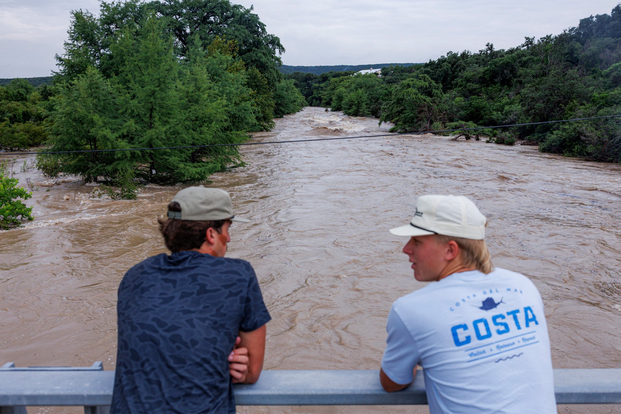
Things aren’t necessarily any prettier outside of the smoke-zone — just wetter. Communities situated around the Guadalupe River in Texas are reeling after near endless rainfall triggered massive floods across the state for the second year in a row.
So far, at least one person is dead, while thousands have been forced to evacuate. At least 57 counties representing over six million people were placed under flood watches over the past few days. With even more rain on the horizon, it remains to be seen when Texas will get relief from the torrential downfalls.
Stepping back, it’s clear this cascade of extremes isn’t happening in a vacuum. The overlapping wildfires, floods, and heat waves are all being amplified by the same climate forces: a rapidly warming planet, fueled in no small part by skyrocketing carbon emissions from the US itself.
All in all, it’s been an action-packed summer as the El Niño cycle rolls on — and unfortunately, the devastation is far from over.
While they were at it, the Trump administration also ripped up a project that would have vastly improved the country’s ability to monitor wildfires. The GeoXO program was a project originally encompassing six satellites that would greatly improve the resolution available to the National Oceanic and Atmospheric Administration to monitor atmospheric conditions like wildfire smoke, as well as weather events like lightning strikes, and climate observations such as color changes in the ocean’s surface.
The six satellites were meant to encompass three regions split between the US West, Central, and East. Starting in April 2025, however, the Trump administration directed the NOAA to make drastic cuts to GeoXO. These included cutting two satellites from the mission altogether — scrapping the central observation region entirely — and canceling major contracts for existing GeoXO instruments. The purported goal was to refocus the program on a “core weather mission,” as opposed to long-term climate monitoring, following the administration’s broaderattacks on any effort to mitigate or even mention climate change.
One of those cancelled instruments, the GeoXO Atmospheric Composition device, was a high-resolution spectrometer designed to give the NOAA advanced capabilities to monitor air pollutants, like ozone, nitrogen dioxide, formaldehyde, and excess particulate matter. In the long term, the tool would have helped scientists paint a clearer picture of how particular weather events relate to broader climate shifts, an NOAA report explains.
Of course, the timing of the cancellation couldn’t have been worse. Huge swaths of the United States and Canada are currently being smoked out by noxious fumes emanating from hundreds of wildfires across North America.
Though the GeoXO program wouldn’t have gone live until the 2030s, Trump’s decision represents a devastating loss for our future ability to monitor this exact phenomenon, which is becoming something of an annual tradition for millions of people.
As Susan Anenberg, chair of environmental and occupational health at George Washington University observed, the NOAA “had spent years planning an air pollution instrument on the GeoXO satellite which would provide near-real-time, location-specific data on smoke levels, giving people the information they need to avoid exposure.”
Anenberg explained that the public health benefits this kind of monitoring would provide “could amount to about $13 billion per year.”
“As smoke events happen more often,” Anenberg continued, “we need more data, not less.”
The collapse of a landmark Amazon soy pact will drive at least 1.4 million hectares (3.5 million acres) of extra deforestation in Brazil over the next decade, releasing carbon emissions equal to Canada's annual output, according to an analysis published Thursday.
For centuries, ancient seafarers have told tales of fabled lost lands. They have been known by many names—Ultima Thule, Hy-Brasil, the Fortunate Isles, and of course, the legendary lost city of Atlantis.
Now, scientists say Earth’s hidden plumbing system may be feeding one of its strangest ecosystems—an area on the Atlantic seafloor that conjures images of such legendary landscapes lost to time and memory.
Known as the Lost City hydrothermal field, this ancient Atlantic oddity is doing more than just broadening our view on how extremophiles thrive in some of our planet’s least hospitable environments: it offers a potential model for how extraterrestrial life may thrive elsewhere in our solar system.
In a recent paper published in Geophysics, Geochemistry, and Geosystems, an international team of researchers finally discovered the system behind these hydrogen- and methane-rich alkaline hot springs that feed the Lost City ecosystem.
The white carbonate chimneys that emit these gases provide an alternative to sunlight as the Lost City’s primary energy source, allowing life to thrive in a challenging deep ocean environment.
A view of the Lost City hydrothermal vent, located adjacent to the Mid-Atlantic Ridge (Image Credit: Susan Lang, University of South Carolina/National Science Foundation/ROV Jason 2018 WHOI)
Searching Near The Lost City
Those precious nutrients coming from these vents were created by underground reactions. It turns out that the water feeding the Lost City is likely part of a larger underground system, where extreme processes imbue the liquid with essential nutrients.
The discovery came from nearly a mile below the Atlantis Massif, a large block of Earth’s crust that forms an underwater mountain range. This dome-shaped region stretches for 10 miles and rises 14,000 feet above the ocean floor.
Above, a map shows the location of the Lost City on the Atlantis Massif (Image Credit: NOAA)
Geologists believe this formation originated between 1.5 and 2 million years ago, as tectonic plate movement pulled it out from beneath the Mid-Atlantic Ridge, forming a new feature on the ocean floor.
From aboard the Joint Oceanographic Institutions for Deep Earth Sampling (JOIDES) ship Resolution, scientists drilled their 4,160-foot-deep hole about 2,600 feet north of the Lost City. They were intrigued to find that the water recovered from the hole had a chemical composition extremely similar to that of water emerging from the Lost City vents.
Beneath The Ocean Floor
From their drill site, they pumped water from varying depths up to the surface for examination.
Roughly the first 1,500 feet consisted primarily of seawater and freshwater from the drilling process, yet at lower depths, they found water that had risen from beneath the rock. At the deepest depths, up to 80% of the sample came from these subterranean regions.
Their detailed analyses revealed that the water had reacted with the surrounding minerals to gain calcium while losing magnesium, a reaction that would require prolonged exposure to rocks at a temperature of at least 572°F. Despite this finding, the hole was much cooler when the team took their samples.
Typically, a water-rock reaction with gabbroic and ultramafic rock would produce such results that are high in calcium, yet with no magnesium. Other components, such as lithium, rubidium, cesium, and strontium, were found in the water at both the bore site and Lost City.
One of the Lost City’s many carbonate spires is shown in this image from the 2005 Lost City Expedition (Image Credit: IFE, URI-IAO, UW, Lost City Science Party; NOAA/OAR/OER; The Lost City 2005 Expedition)
The findings are consequential for providing the first direct evidence of this extremely hot water circulating beneath the Atlantis Massif through gabbroic and ultramafic rock. In this hidden plumbing system, seawater reaches deep within oceanic plates, providing energy to these deep-sea environments and potentially supporting their microbial life.
Feeding The Lost City
As researchers have now demonstrated that hydrogen-enriched water can naturally form deep within the Earth through rock reactions, researchers say there are major implications for our understanding of the Earth and beyond.
For one, it adds a new element to Earth’s energy cycles, explaining how life persists under such difficult, dark conditions. Secondly, it offers intriguing new ideas about how life might persist in extraterrestrial environments, as humans continue to search for it elsewhere in the cosmos. The strange conditions of the Lost City ecosystem are thought to be a potential model for how life could persist in the global oceans of ice-covered worlds such as Jupiter’s moon Europa or Saturn’s moon Enceladus.
However, some uncertainty about the samples does remain. Seawater, freshwater, and drilling contaminants were present in the samples, and the exact proportions attributable to gabbro or ultramafic rock are unknown. Also, while this is evidence for an underground connection between the borehole and the Lost City chimneys, it is not conclusive proof that they are connected.
Plans are already underway to return once the borehole has stabilized to collect pristine samples that will allow researchers to answer questions about where and how these reactions occur, as well as the amount of energy they add to the water. From the most inhospitable regions on Earth to the quest for organisms among the stars, the research underway deep within our oceans is providing new answers to how such life persists.
Micah Hanks, Editor in Chief of The Debrief, also contributed to this reporting.
Ryan Whalen covers science and technology for The Debrief. He holds an MA in History and a Master of Library and Information Science with a certificate in Data Science. He can be contacted at ryan@thedebrief.org, and follow him on Twitter @mdntwvlf.
For communities worried about PFAS contamination, waiting for test results can mean days of uncertainty. A University of Tasmania trial has used a mobile laboratory equipped with portable liquid chromatography-mass spectrometry (LC-MS) technology to test soil and water on site and provide an early indication of PFAS contamination within six hours.
Approximately 90% of the U.S. population relies on public water systems. A significant portion of the water supplying those systems comes from forested lands, which means policies affecting forests also affect water access.
The vast majority of carbon emissions caused by "mega-events" such as World Cups and global concert tours come from audience travel, according to University of Cambridge researchers. In a new study, researchers estimate that expanding to 48 teams for this year's World Cup increased emissions by well over half a million metric tons to some 4.23 million metric tons of carbon for the whole tournament, 82% of which comes from traveling fans, with around 3 million metric tons from flying alone.
Plastic pollution has become a global environmental crisis, with an estimated 11 million tons of plastic entering the oceans each year. As larger plastic debris breaks down into microplastics, these tiny particles are transported throughout marine ecosystems by ocean currents, threatening marine life and ultimately entering the human food chain.
Wetlands are a significant producer of methane, a greenhouse gas more potent than carbon dioxide. Yet not all of it escapes into the atmosphere. One reason is crabs. A study published in the journal Environmental Science & Technology has shown that crab burrows can substantially increase natural processes that consume methane before it reaches the atmosphere.
Humans have been around for only about 0.01% of Earth’s history, yet we’ve altered natural landscapes and processes that have remained stable for millions of years. A team of researchers from the University of Glasgow recently studied a formerly sandy beach in the UK that highlights how fast these changes can occur.
Industrial steel and iron furnaces operated extensively in the UK from 1856 until the 1980s. During these decades, workers dumped roughly 335 million cubic meters (90 billion gallons) of molten furnace waste, called slag, across the country. Of that, roughly 27 million cubic meters (6 million gallons) now sits on the coast of Derwent Howe in a massive 30-meter (100-foot), solidified cliff.
The researchers analyzed this region to understand how man-made, or anthropogenic, materials influence the way rocks form. Rocks naturally form and change into different types of rocks over million-year timescales, through a continuous process called the rock cycle. When the team uncovered a soda can tab manufactured in 1989 within the hardened grains, or clasts, of slag, they concluded that the beach had solidified within the last 35 years. Based on this discovery, they proposed a new term for rocks formed from anthropogenic sediments: the anthropoclastic rock cycle.
The team collected 1,300 grains of sediment from 13 sites in the study area and found that 83% were slag. Natural beach sediments, like quartz sand, comprised only about 17% of the grains. As wind and waves broke down the cliff, slag clasts fell off and became rounded by friction as tides transported them from the cliff to the beach.
At the boundary where the slag touched the beach, the researchers also saw evidence that the slag had seeped into the underlying wet sediment. The rocks there resembled a type of rock called peperite, which forms when lava flows over wet, loose sediments. They concluded that this peperite-like rock formed as the molten slag flowed over the still sandy beach. Slag is much thicker than wet sand, so the resulting rock looked like blobs of slag encased in sandy rock.
The researchers then visually observed how the slag grains were arranged in the solidified rock to reconstruct the tidewater speeds at different points in the coast’s history. The different ways sediments are arranged within a rock are called sedimentary features, and they reflect the processes that formed the rock. For example, as water flows over sand, it forms small, dune-like ripples. When the sand beds harden into rock, the ripples are preserved as features known as trough cross-bedding.
Faster water erases any ripple formations and instead forms horizontal layers in the sediment, known as planar lamination. The researchers observed both trough cross-bedding and planar laminations preserved in the slag beach rocks. These sedimentary features indicate that the beach at Derwent Howe turned from loose sediment into rock in a generation.
To investigate why this beach rapidly solidified, the researchers scanned the surfaces of the beach rock with electron beams and X-rays using a scanning electron microscope, or SEM, equipped with an energy dispersive X-ray, or EDX. Every chemical element emits a unique set of X-rays with different wavelengths when hit with EDX, so the researchers could compare the X-rays from their samples to databases of known mineral X-ray signatures. They identified the primary binding agents as calcium- and iron-rich minerals like calcite, goethite, and brucite. These minerals are called cements because they bind grains of sediment together.
The researchers expected the slag to produce these cement compositions, since extracting metal ores from rock enriches the resultant slag in calcium, magnesium, manganese, and iron, which readily dissolve in water. When water flowing between closely packed slag grains can no longer hold additional dissolved elements, those elements precipitate as solid mineral cements. Since cements only form when the water has very high concentrations of dissolved elements, the introduction of massive amounts of slag caused the cement to form faster than it would in waters with lower concentrations of elements.
The researchers suspected that the anthropoclastic rock cycle they observed at Derwent Howe is not uncommon. Since slag contains all the elements necessary to form rocks when in contact with seawater and air, slag deposits all over the world could be rapidly influencing their local environments. With this in mind, the team suggested that future researchers update geological models to account for human contributions to the natural rock cycle.
Scientists are paying increasing attention to pollution that comes from vehicle tires. Unlike exhaust emissions, tiny particles released as tires wear down receive much less public attention, yet they are one of the largest sources of microplastic pollution from road traffic. As these particles mix with ozone in the air, they create a chemical called […]

 Login