Alvin Mitchell, a NASA C-20A aircraft quality assurance inspector, completes preflight checks at NASA’s Armstrong Flight Research Center in Edwards, California, on April 29 for a mission over Central California. On May 2, the aircraft departed for the Tropical Synthetic Aperture Radar campaign carrying NASA’s Uninhabited Aerial Vehicle Synthetic Aperture Radar.
NASA/Ryan Kline
Data from a NASA campaign in Panama and Peru will help communities prepare for tropical floods in cloud-covered areas, improve scientific understanding of forest health, and support planning for spaceborne missions.
NASA’s C-20A aircraft from Armstrong Flight Research Center in Edwards, California, flew the Uninhabited Aerial Vehicle Synthetic Aperture Radar (UAVSAR) instrument, developed at NASA’s Jet Propulsion Laboratory in Southern California, to gather mission data. While flying repeat paths, the instrument collected high-resolution radar data from a pod mounted beneath the aircraft. The monthlong campaign, known as Tropical Synthetic Aperture Radar, or TropiSAR, concluded on June 4 after 17 flights totaling 75 hours.
Airborne data were captured over Peru in the same times and locations as data captured by the NISAR (NASA-ISRO Synthetic Aperture Radar) satellite to validate key NISAR capabilities and support calibration of the satellite’s L-band radar system. The science validation targeted two measurements: tropical rainforest flood extent within the Pacaya-Samiria National Reserve in Peru, one of the world’s largest protected flooded forests, and glacier movement in the Huascarán National Park in the Peruvian Andes, which is home to the largest concentration of tropical glaciers. The mission also gathered detailed 3D views of tree height and density to estimate biomass, assess forest health, and better understand how forest ecosystems store and release carbon.
In Panama, TropiSAR also supported NASA’s Airborne Validation Unified Experiment: Land and Ocean (AVUELO) campaign in collaboration with the Smithsonian Tropical Research Institute. Airborne radar data were collected from dry forests and coastal wetlands with the goal of better understanding Panama’s rich biodiversity. By linking field measurements with airborne and satellite observations, AVUELO may advance new methods for studying the tropics.
Lead researcher Federico De Pascalis of the Italian Institute for Environmental Protection and Research (ISPRA) holds a Mediterranean storm petrel.
A. Benvenuti
You might think birds skimming over the ocean wouldn’t seek wind unless it was pushing them in the right direction, but NASA-funded researchers have learned that storm petrels find stiff crosswinds worth the slowdown, in return for the clues and cues the gusts carry.
In a paper published by the Royal Society’s Biology Letters May 13, researchers from Woods Hole Oceanographic Institution (WHOI) and the Italian Institute for Environmental Protection and Research (ISPRA) found that Mediterranean storm petrels actively sought out crosswinds, which carried odors the birds used to navigate toward prey. The birds were effectively trading the extra energy needed to fly in a crosswind for the information it blows toward them.
These sparrow-sized birds routinely undertake foraging trips hundreds of miles over the sea, returning to the breeding colony to relieve their partners from incubation duties. Until recently, their small size has precluded researchers’ ability to tag them, keeping their journeys a mystery. In 2020 and 2021, working on the Italian island Sardinia, the team, led by ISPRA and WHOI, attached lightweight GPS sensors to the birds, adding just 3.3% of the birds’ weight as they set out over the Mediterranean Sea.
This finding could help reveal how changing winds might impact seabirds’ feeding, breeding, energy levels, and survival, adding insights about patterns of nutrients in the sea — and the forces that create them.
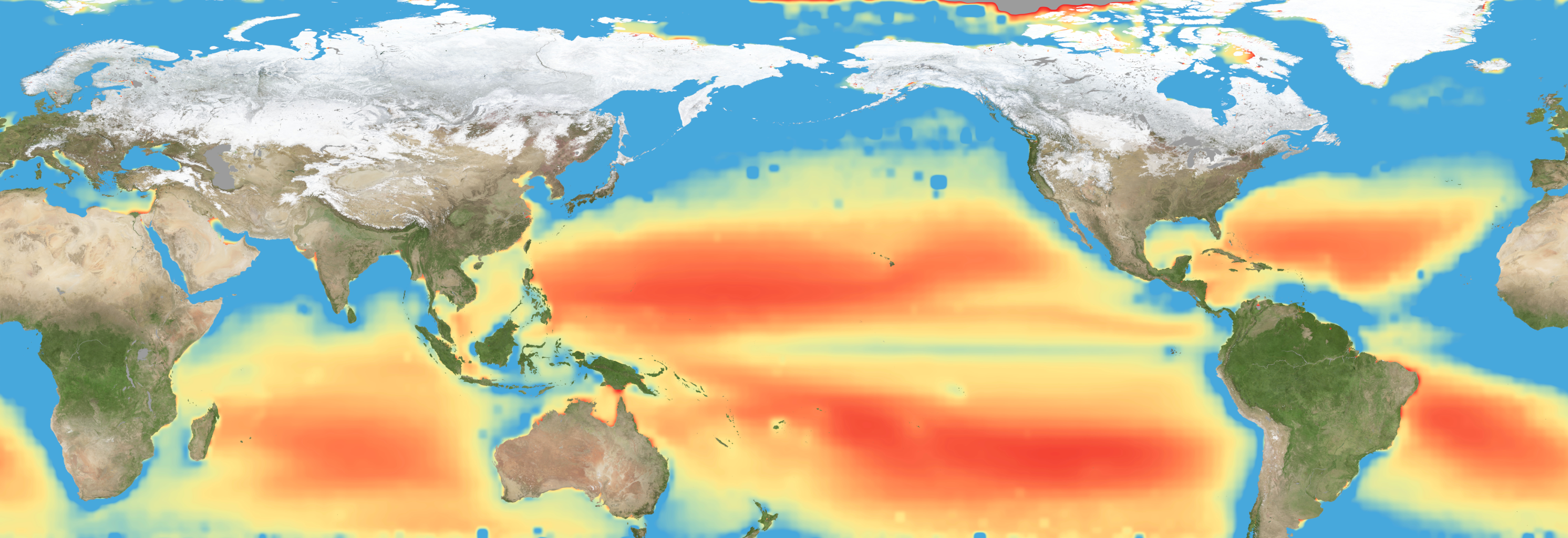
Warming waters decrease upwelling and lead to stress on marine microorganisms due to limited availability of vital nutrients. Red indicates the regions of highest nutrient-related stress.
Kel Elkins/NASA’s Scientific Visualization Studio
Editor’s note: This article was updated on June 5.
A new study combining NASA satellite observations, ocean surveys, and genetic testing on marine microorganisms found evidence that warming ocean waters may be limiting nutrient availability across much of the global ocean. The researchers report that this nutrient stress affects microscopic marine organisms and could influence marine ecosystems over time.
The research, published June 5 in Science Advances, tracked the condition of phytoplankton, which form the base of ocean food webs. Rather than measuring nutrients like nitrogen, iron, and phosphorus directly, the researchers inferred stress by tracking subtle shifts in the ratio of carbon to chlorophyll in phytoplankton observed from space. When the amount of chlorophyll decreases relative to carbon as seen in satellite data, it’s an indication that the plankton are stressed.
“As our ocean continues to change, the ability to observe and track ocean conditions through sustained, high quality remote sensing observations has never been more important,” said Laura Lorenzoni, Program Scientist for NASA’s Ocean Biology and Biogeochemistry Program at NASA Headquarters in Washington. “This is fundamental, as plankton communities are the base of the marine food web on which important economic activities rely.”
The research team combined two decades of data from NASA’s Aqua satellite’s Moderate Resolution Imaging Spectroradiometer (MODIS) sensor with plankton samples collected on research cruises around the world. The approach linked large-scale satellite observations with genetic markers in Prochlorococcus, a tiny but abundant marine microbe that shows signs of nutrient stress in its DNA. The result is a global map revealing where phytoplankton are thriving and where they’re struggling.
Ocean chlorophyll, as observed with NASA's Moderate Resolution Imaging Spectroradiometer (MODIS) instrument between January 2010 through May 2016.
Marit Jentoft-Nilsen/NASA's Goddard Space Flight Center
The strongest indications of nutrient stress on plankton appeared in the subtropical gyres, which are vast, relatively calm regions of the Atlantic, Pacific, and Indian oceans. In these areas, a layer of warm surface water stifles the flow of colder water from deeper in the ocean.
“When the surface of the ocean warms, it generates this very stable situation where a layer of low-density water sits on top of higher-density cold water,” said study coauthor Adam Martiny, an oceanographer at the University of California, Irvine. “You’ve probably experienced that if you’ve ever been to a lake in the summertime—it’s super warm right on the surface, and very cold deeper down when you stick your legs in.”
This layering blocks the upward flow of nutrient-rich water, limiting the availability of ocean surface nutrients that are crucial for plankton. In the South Pacific, one of the most nutrient-poor regions, a layer of warm surface water contributed to nitrogen and iron shortages, producing the most severe nutrient-related stress that the team discovered.
But the researchers were surprised to find that parts of the North Atlantic experience less nutrient stress than expected. Although there was evidence of a lack of phosphorus, the impact on microorganisms was comparatively mild.
That difference may reflect the biology of the organisms themselves. Phytoplankton can partially compensate for phosphorus shortages by recycling phosphorus more efficiently or replacing phosphorus-rich molecules inside their cells. Nitrogen shortages are harder to overcome because nitrogen is crucial for the proteins and cellular machinery required for photosynthesis and nutrient uptake.
The study revealed that nutrient stress is strongly correlated with seasons and major weather cycles such as El Niño and the Pacific Decadal Oscillation, which lead to warming waters in the Pacific Ocean. During La Niña events, which cool water over a large part of the Pacific, stronger upwelling brought more nutrients to surface waters and reduced stress in some regions. Superimposed on those multi-year cycles, however, was a longer-term trend.
From 2002 through 2021, average sea-surface temperatures increased across nearly 90% of the ocean area examined in the study. Over the same period, nutrient stress generally intensified, consistent with previous hypothesis that warming oceans may become increasingly stratified and less able to replenish surface nutrients.
In many nutrient-poor regions of the Southern Hemisphere, however, the researchers found evidence that nutrient stress had not increased as much as expected despite significant warming. They suspect that microbes capable of capturing nitrogen from the air may partially offset the effects of reduced nutrient mixing.
That finding hints that marine ecosystems may possess more resilience to warming climates than some models predict. It also underscores the complexity of forecasting how ocean biology will respond to continued warming.
“We have two really powerful tools,” said study coauthor Michael Behrenfeld, a biochemist with Oregon State University in Corvallis, Oregon. The tools include satellite observations and cellular studies. “Both produce big data sets, but they are kind of opposites. We have very detailed data about microscopic phytoplankton … and then we have global coverage with satellites.”
By combining satellites that monitor the entire ocean with genetic clues carried inside microscopic plankton, the researchers say they are gaining a new way to track biological responses to changing environmental conditions near real time.

 Login