❌

Reading view

How NASA Science and Artemis Are Shaping the 2026 FIFA World Cup 

Researchers tested soccer balls aboard the International Space Station to study how internal mass affects motion and stability in microgravity.
NASA

As the FIFA World Cup approaches, NASA is bringing space science and engineering to soccer fans worldwide. From June 11 to July 19, 2026, NASA will host an exhibit at FIFA Fan Festival™ Houston where visitors can learn how research aboard the International Space Station benefits life on Earth and experience missions in low Earth orbit, the Moon, and beyond through the Artemis program. 

On June 11, as the FIFA World Cup begins, NASA’s exhibit at Fan Festival Houston will open to the public. The event is free to attend and open for every match of the tournament in East Downtown, Houston. On June 20, Johnson Space Center Director Vanessa Wyche will introduce select Artemis II crew members following their historic mission around the Moon. The crew will participate in World Cup activities ahead of the Netherlands-Sweden match in Houston and will appear on the Fan Festival Houston main stage to share their experience with fans. 

The connection between NASA and the World Cup goes beyond the exhibit floor, reaching all the way to orbit. NASA spinoff technologies are innovations developed for space exploration that go on to shape commercial products and everyday life – even on the soccer field. 

For more than 25 years, research aboard the International Space Station has enabled breakthroughs in science, technology, and human health while advancing innovations that benefit people on Earth. That work includes studies that improve understanding of the aerodynamics and physics involved in soccer ball flight. 

In partnership with the ISS National Laboratory in 2019, researchers used the station’s microgravity environment to study how a soccer ball’s internal mass affects its motion, stability, and rotation. The findings have improved understanding of how embedded technologies, including match-ball sensors, can influence performance during play. The research contributed to studies used in the development and evaluation of soccer balls for major international tournaments, including FIFA World Cup competition. 

Understanding the relationship between an object’s center of mass and its geometric center is key to predicting how free-flying objects move, including spacecraft, satellites, and aircraft. 

Since 2022, Adidas has embedded electronics inside official match balls used in major tournaments. The sensors track speed, position, and contact in real time to support officiating and broadcast technology. But those sensors also add mass in specific locations inside the ball, and uneven mass distribution can affect how a ball moves through the air. 

The space-based research has helped improve understanding of how internal mass, including embedded sensors, can influence stability and rotation in real-world playing conditions. 

This work builds on earlier research into how spinning objects behave in microgravity. 

Engineers at NASA’s Ames Research Center in Silicon Valley, California tested Adidas’ Brazuca ball, developed for the 2014 FIFA World Cup, in wind tunnel conditions at the Fluid Mechanics Laboratory. Researchers studied aerodynamic behavior, including how low-spin kicks can produce “knuckling,” where the ball moves unpredictably due to unstable airflow across the seams. NASA engineers measured the speeds and flow conditions where this effect was most pronounced. 

Adjustments in panel shape, seam depth, and surface texture can influence flight consistency, helping determine whether a ball curves, dips, or holds its line during play. 

Now, NASA and Adidas are presenting that science through a STEMonstration that compares how differently balanced soccer balls spin and move in microgravity. The experiment shows how the same physics that governs motion in space also shape the game millions watch on Earth. 

Through research aboard the International Space Station and technology developed for exploration, NASA continues to demonstrate how discoveries made for space can benefit people on Earth—including athletes and fans participating in the world’s most popular sport. 

Watch the soccer ball STEMonstration video: 

💾

Have you ever kicked a soccer ball and wondered why it curves, spins, or sometimes wobbles? NASA astronaut Jessica Meir aboard the International Space Statio...
  •  

Supersonic!

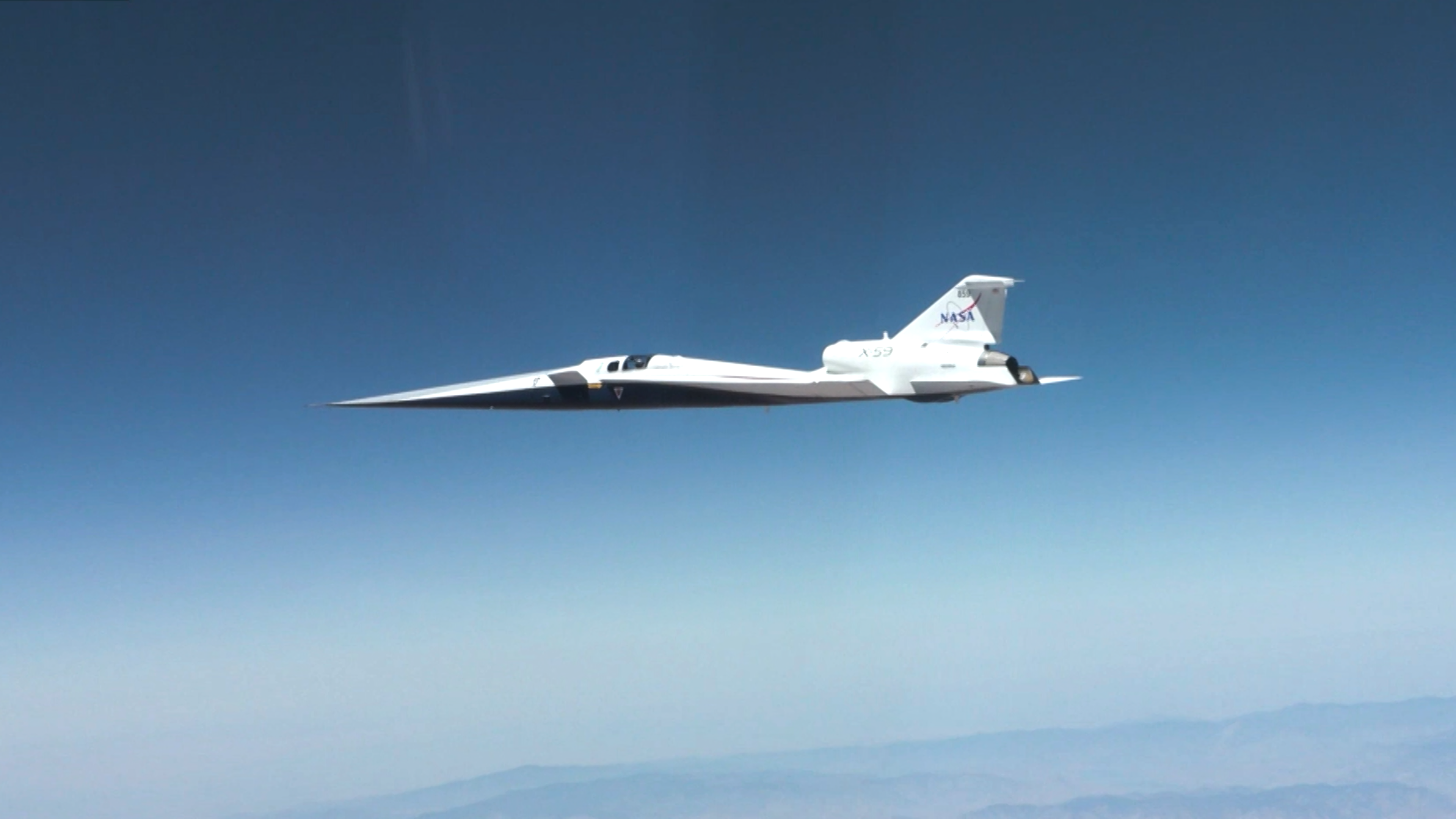
NASA’s X-59 quiet supersonic research aircraft flies through the blue sky. The plane has a distinctive long, sharp nose. There are mountains visible at the bottom of the photo.
NASA/Lori Losey

On June 5, 2026, NASA’s experimental X-59 aircraft flew faster than the speed of sound for the first time, setting the stage for demonstrating its quiet supersonic capabilities later this year. NASA test pilot Jim “Clue” Less took off and landed at Edwards Air Force Base in California, reaching a top speed of approximately Mach 1.1 (713 mph). The flight lasted 81 minutes, with the team focusing on flying qualities at both subsonic and then supersonic speeds.

The X-59 is the centerpiece of NASA’s Quesst mission, which aims to demonstrate quiet supersonic flight and help enable commercial supersonic flight over land worldwide. These advancements will help travelers reach their preferred destinations faster, spending less time in the air.

Learn more about the milestone and Quesst.

Image credit: NASA/Lori Losey

  •  

NASA’s INCUS Satellites Progress Toward Launch

2 Min Read

NASA’s INCUS Satellites Progress Toward Launch

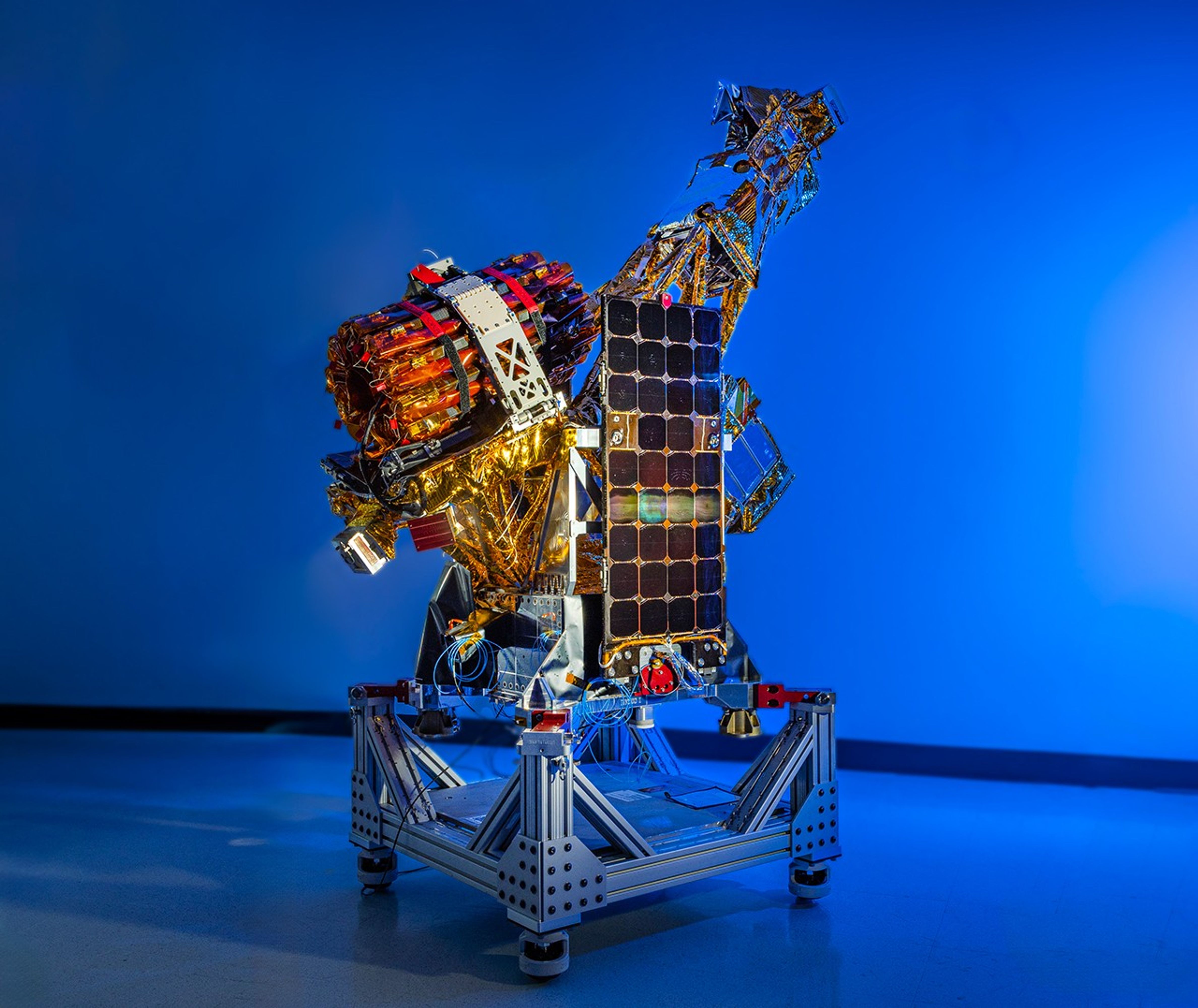
A complex spacecraft partially wrapped in gold-colored foil and featuring a large rectangular solar panel stands on a metallic support structure against a solid blue background.
PIA26614
Credits:
Blue Canyon Technologies

Downloads

NASA’s INCUS Satellites Progress Toward Launch

JPEG (10.32 MB)

Description

One of the three satellites that make up NASA’s INCUS (Investigation of Convective Updrafts) mission sits on a fixture at the facilities of Blue Canyon Technologies in Lafayette, Colorado. The satellite completed testing in preparation for launch in late May 2026. The mission will make the first space-based survey of the dynamics of tropical convective storms.

The three nearly identical satellites will fly in tight coordination in low Earth orbit, with the first and second satellites separated by 30 seconds, and the second and third satellite separated by 90 seconds. 

Each satellites carries a radar designed to observe the vertical motion of air and water — known as convective mass flux — as storms develop and evolve. The middle satellite will also carry a microwave radiometer.

The INCUS mission is set to launch in 2027 from NASA’s Wallops Flight Facility in Virginia.

Funded through the Earth Venture Mission-3 acquisition under NASA’s Earth System Science Pathfinder Program and led by principal investigator Sue van den Heever at Colorado State University in Fort Collins, INCUS is one of several missions fulfilling the clouds, convection, and precipitation requirements of NASA’s Earth System Observatory, a set of interconnected missions set to study our home planet’s dynamic natural systems and how they interact. The mission is also part of FALCON (Fleet for the Atmosphere Linking Commercial Observations with NASA), a fleet of atmosphere-observing satellites that will combine hardware contributions from NASA centers, universities, and commercial partners.

  •  

Digging Back in Time in the UAE

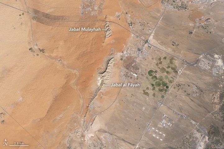
Limestone ridges appear as linear features running north–south with orange-toned desert to the west and a darker-toned mountain range to the east.
Jabal al Fāyah rises from the Rub’ al Khali desert in an image captured by the OLI (Operational Land Imager) on Landsat 8 on October 23, 2025.
NASA Earth Observatory / Lauren Dauphin

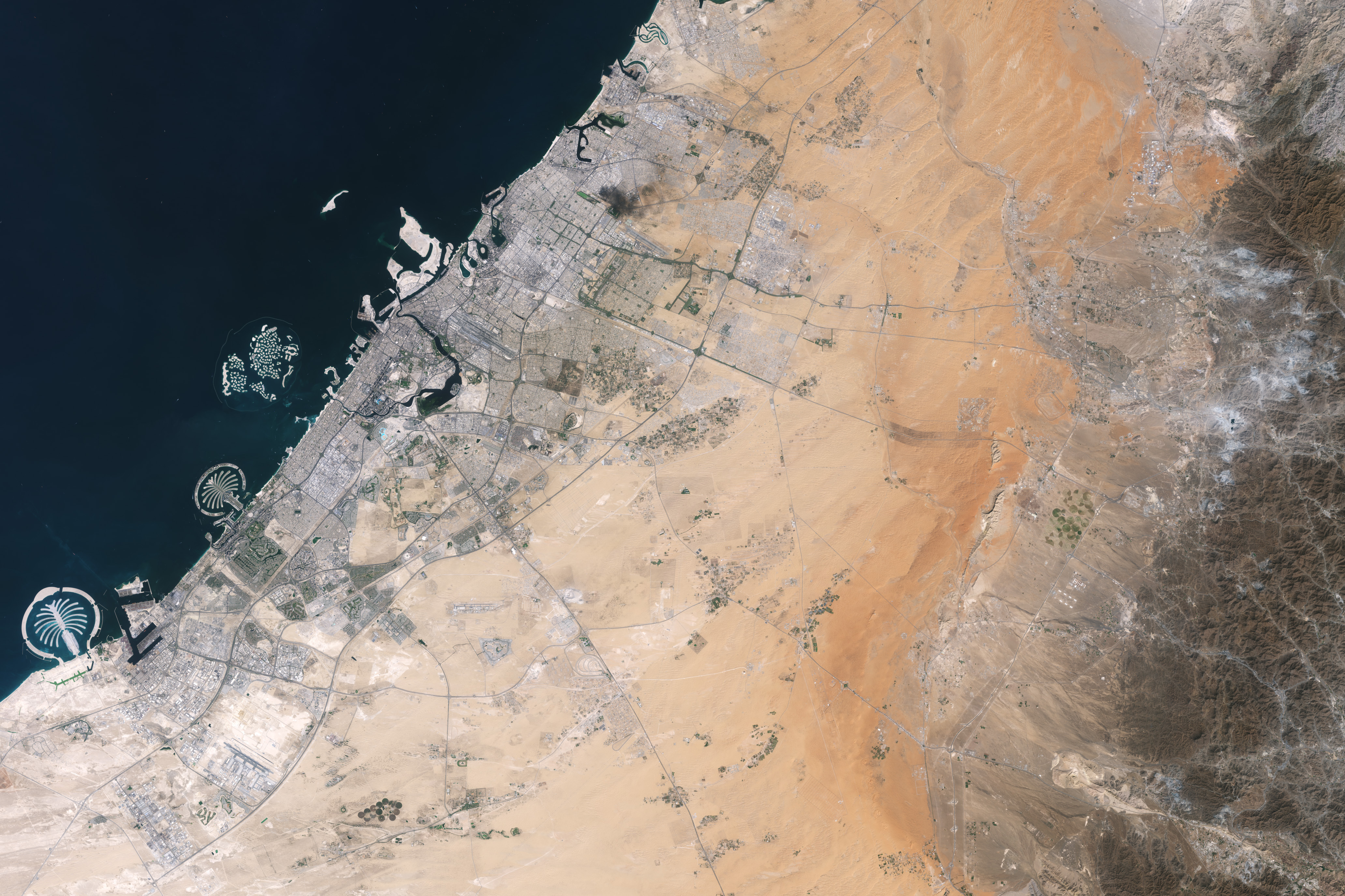
About an hour’s drive east of Dubai’s gleaming towers and artificial islands, a quieter, more natural landscape takes shape. At the far northern edge of the Rub’ al Khali, a saffron-colored sand sea laps against the Al-Hajar Mountains. A series of pale ridges rises finlike from the desert plain, with the largest—Jabal al Fāyah—standing 412 meters (1,352 feet) above sea level.  

The Landsat 8 satellite captured this image of the ridges cutting across the Emirate of Sharjah in the northern part of the United Arab Emirates on October 23, 2025. To geologists, the limestone ridges are a reminder of the region’s watery past, signs that this land lay underwater tens of millions of years ago when the sedimentary rock layers were deposited.

Jabal al Fāyah functions as a barrier, trapping windblown sand in dune fields to its west. The weathering of iron-bearing minerals in the sand grains gives the dune fields their orange hue. To the east, the branching channels of overlapping alluvial fans extending from the Al-Hajar Mountains carry gravels and eroded sediments from basalts and other dark mafic rocks. 

The dark rocks to the east—part of the Samail Ophiolite—are known to geologists for being among the world’s largest, best-preserved, and most accessible exposures of ancient oceanic lithosphere, the rigid outer layer of Earth that includes both the crust and upper mantle. Oceanic lithosphere like this is normally subducted and recycled back into the mantle when tectonic plates collide. But in this area, a large section from beneath the Tethys Sea was scraped off and thrust onto the Arabian plate in a process called obduction.  

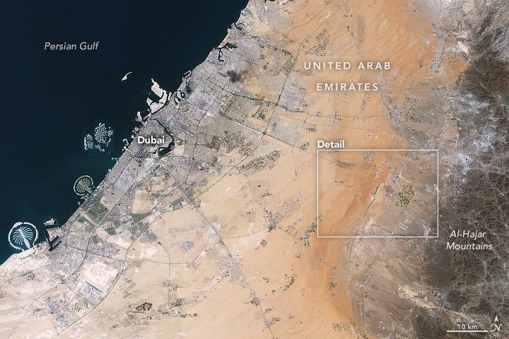
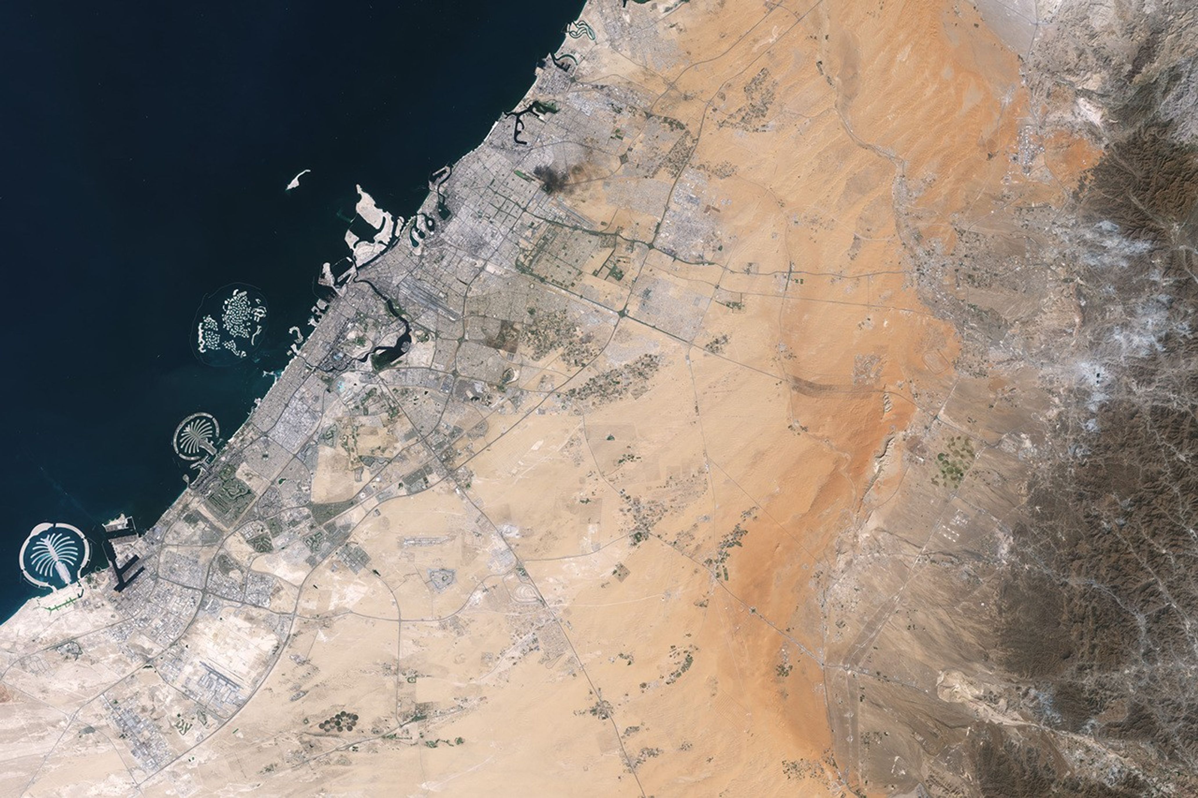
Development associated with Dubai appears as a light gray zone along the coast of the Persian Gulf with the dark gray Al-Hajar Mountains on the far right side of the image. A ridge lies in the middle of the image in a sandy area.
Dubai lies to the west of the limestone ridges, and the Al-Hajar Mountains lie to the east, in an image acquired by the OLI (Operational Land Imager) on Landsat 8 on October 23, 2025.
NASA Earth Observatory / Lauren Dauphin

The Jabal al Fāyah ridges themselves are made up of marine limestone that was deposited on top of the ophiolite over tens of millions of years spanning the late Cretaceous through the early to mid-Paleocene. Limestone typically forms along continental margins in warm, shallow oceans, often in lagoons and coral reefs, out of the calcium carbonate found in the shells and skeletons of marine life. In many parts of the ridges, coral fragments and marine invertebrate fossils are visible embedded in the rock. A feature called Fossil Rock sits a few kilometers north of Jabal al Fāyah and adjacent to the limestone ridge Jabal Mulayḩah. It contains an abundance of snail, clam, and sea urchin remains. 

For archaeologists, the ridges are at the center of a much more recent tale of human adaptation and survival that has played out in just the past few hundred thousand years. The ridges and parts of the surrounding landscape—inscribed as a UNESCO World Heritage site in 2025—are dotted with dozens of archaeological sites that trace human occupation on the Arabian Peninsula back to between 210,000 and 120,000 years ago, to the Middle Paleolithic. That was a period when waves of anatomically modern humans (Homo sapiens) migrated out of Africa and shared the planet with other groups such as Neanderthals.   

Many of the sites contain stone flakes, blades, scrapers, hand axes, and other stone tools. The archaeological treasure trove offers early evidence of modern humans surviving in a harsh desert environment and raises questions about the routes modern Homo sapiens may have taken on their journey out of Africa.  

Geological evidence indicates that lakes periodically formed on the east side of the ridge, providing critical food and water resources that would have supported early inhabitants in this unforgiving climate. Rocky overhangs along the ridge would have provided shelter from the heat and wind. Some of the sites show evidence of intermittent occupation beginning as early as 210,000 years ago, making this one of the earliest signs of human habitation on the Arabian Peninsula.   

NASA Earth Observatory images by Lauren Dauphin, using Landsat data from the U.S. Geological Survey. Story by Adam Voiland.

Downloads

Development associated with Dubai appears as a light gray zone along the coast of the Persian Gulf with the dark gray Al-Hajar Mountains on the far right side of the image. A ridge lies in the middle of the image in a sandy area.

October 23, 2025

JPEG (3.89 MB)

References & Resources

You may also be interested in:

Stay up-to-date with the latest content from NASA as we explore the universe and discover more about our home planet.

Thailand’s Krabi Coast

3 min read

The coastal province features striking tropical karst landscapes and sandy beaches alongside a mix of natural land cover and developed…

Article

A Bit of Gray on an Emerald Isle

3 min read

Ireland is best known for its many greens, but the striking grays of the island’s Burren region also stand out…

Article

Eyeing the Richat Structure

3 min read

The circular geologic feature in northwestern Africa can be hard to recognize from the ground, but it is obvious when…

Article
  •  

NASA Satellites Help Map Ocean Nutrient Stress 

A flat map of the world shows regions in the ocean colored red to indeicate elevated levels of stress on plankton due to a lack of nutrients.
Warming waters decrease upwelling and lead to stress on marine microorganisms due to limited availability of vital nutrients. Red indicates the regions of highest nutrient-related stress.
Kel Elkins/NASA’s Scientific Visualization Studio

Editor’s note: This article was updated on June 5.

A new study combining NASA satellite observations, ocean surveys, and genetic testing on marine microorganisms found evidence that warming ocean waters may be limiting nutrient availability across much of the global ocean. The researchers report that this nutrient stress affects microscopic marine organisms and could influence marine ecosystems over time.

The research, published June 5 in Science Advances, tracked the condition of phytoplankton, which form the base of ocean food webs. Rather than measuring nutrients like nitrogen, iron, and phosphorus directly, the researchers inferred stress by tracking subtle shifts in the ratio of carbon to chlorophyll in phytoplankton observed from space. When the amount of chlorophyll decreases relative to carbon as seen in satellite data, it’s an indication that the plankton are stressed. 

“As our ocean continues to change, the ability to observe and track ocean conditions through sustained, high quality remote sensing observations has never been more important,” said Laura Lorenzoni, Program Scientist for NASA’s Ocean Biology and Biogeochemistry Program at NASA Headquarters in Washington. “This is fundamental, as plankton communities are the base of the marine food web on which important economic activities rely.” 

The research team combined two decades of data from NASA’s Aqua satellite’s Moderate Resolution Imaging Spectroradiometer (MODIS) sensor with plankton samples collected on research cruises around the world. The approach linked large-scale satellite observations with genetic markers in Prochlorococcus, a tiny but abundant marine microbe that shows signs of nutrient stress in its DNA. The result is a global map revealing where phytoplankton are thriving and where they’re struggling. 

Ocean chlorophyll, as observed with NASA’s Moderate Resolution Imaging Spectroradiometer (MODIS) instrument between January 2010 through May 2016.
Marit Jentoft-Nilsen/NASA’s Goddard Space Flight Center

The strongest indications of nutrient stress on plankton appeared in the subtropical gyres, which are vast, relatively calm regions of the Atlantic, Pacific, and Indian oceans. In these areas, a layer of warm surface water stifles the flow of colder water from deeper in the ocean.  

“When the surface of the ocean warms, it generates this very stable situation where a layer of low-density water sits on top of higher-density cold water,” said study coauthor Adam Martiny, an oceanographer at the University of California, Irvine. “You’ve probably experienced that if you’ve ever been to a lake in the summertime—it’s super warm right on the surface, and very cold deeper down when you stick your legs in.” 

This layering blocks the upward flow of nutrient-rich water, limiting the availability of ocean surface nutrients that are crucial for plankton. In the South Pacific, one of the most nutrient-poor regions, a layer of warm surface water contributed to nitrogen and iron shortages, producing the most severe nutrient-related stress that the team discovered. 

But the researchers were surprised to find that parts of the North Atlantic experience less nutrient stress than expected. Although there was evidence of a lack of phosphorus, the impact on microorganisms was comparatively mild. 

That difference may reflect the biology of the organisms themselves. Phytoplankton can partially compensate for phosphorus shortages by recycling phosphorus more efficiently or replacing phosphorus-rich molecules inside their cells. Nitrogen shortages are harder to overcome because nitrogen is crucial for the proteins and cellular machinery required for photosynthesis and nutrient uptake. 

The study revealed that nutrient stress is strongly correlated with seasons and major weather cycles such as El Niño and the Pacific Decadal Oscillation, which lead to warming waters in the Pacific Ocean. During La Niña events, which cool water over a large part of the Pacific, stronger upwelling brought more nutrients to surface waters and reduced stress in some regions. Superimposed on those multi-year cycles, however, was a longer-term trend. 

From 2002 through 2021, average sea-surface temperatures increased across nearly 90% of the ocean area examined in the study. Over the same period, nutrient stress generally intensified, consistent with previous hypothesis that warming oceans may become increasingly stratified and less able to replenish surface nutrients. 

In many nutrient-poor regions of the Southern Hemisphere, however, the researchers found evidence that nutrient stress had not increased as much as expected despite significant warming. They suspect that microbes capable of capturing nitrogen from the air may partially offset the effects of reduced nutrient mixing. 

That finding hints that marine ecosystems may possess more resilience to warming climates than some models predict. It also underscores the complexity of forecasting how ocean biology will respond to continued warming. 

“We have two really powerful tools,” said study coauthor Michael Behrenfeld, a biochemist with Oregon State University in Corvallis, Oregon. The tools include satellite observations and cellular studies. “Both produce big data sets, but they are kind of opposites. We have very detailed data about microscopic phytoplankton … and then we have global coverage with satellites.”   

By combining satellites that monitor the entire ocean with genetic clues carried inside microscopic plankton, the researchers say they are gaining a new way to track biological responses to changing environmental conditions near real time. 

By James Riordon
NASA’s Earth Science News Team

Media contact: Elizabeth Vlock
NASA Headquarters

About the Author

James Riordon

James Riordon

Senior Science Writer

  •  
❌