
❌

Normal view

Earthquake fault irregularities control rupture speed and influence ground motion

28 August 2026 at 09:00

Earthquakes that propagate at higher speeds make the ground move more than it would in slower but otherwise comparable earthquakes, say geophysicists. Using physics-based models, Mohamed Abdelmeguid and colleagues at the California Institute of Technology in the US showed that so-called “supershear” ruptures produce stronger and longer-duration ground motion than equivalent subshear ruptures. Because models of ground motion that underpin infrastructure standards do not account for this effect, these models may need to be updated to accurately describe hazards such as the 2025 Myanmar earthquake, which produced supershear ruptures in both directions.

Geophysicists have identified two categories of earthquake based on how fast their ruptures propagate through the Earth’s crust. Shear waves, or S waves, travel at certain expected velocities (the shear-wave velocity) depending on the stiffness and density of the ground. When a rupture travels faster than the shear-wave velocity of the surrounding ground, it is termed a supershear earthquake. Otherwise, it is subshear.

Although Abdelmeguid notes that supershear ruptures were first predicted theoretically in the 1970s, and have subsequently been observed in both laboratory experiments and the real world, most previous studies focused on their underlying mechanisms and the transition from subshear to supershear. The new study, which appears in the Bulletin of the Seismological Society of America, goes a step further by examining how the ground motion in a supershear quake differs from that of an otherwise comparable subshear one. The question is relevant, Abdelmeguid says, because nearly 36% of strike-slip earthquakes during the past 15 years contained supershear rupture, yet existing models do not factor it in.

Supershear simulations

To address this gap, Abdelmeguid and colleagues developed a dynamic rupture model that generates simulated ground motion data and used it to identify the characteristics of supershear earthquakes. They found that prolonged supershear propagation produces what they term “a distinct spatial pattern of stronger and longer-duration shaking”. However, episodic supershear segments, where rupture speed intermittently changes between supershear and subshear, produce ground motion similar to subshear ruptures.

Simulations like these are important because some supershear rupture scenarios are poorly represented in the observational record. This record is used to develop ground motion models, so simulations can “reveal physical dependencies that may not be apparent from existing observations,” Abdelmeguid says.

Characterizing the 2025 Myanmar earthquake

The 2025 Myanmar earthquake – a supershear quake in which many regions experienced higher than expected ground shaking – is a case in point. It occurred on the 1200-kilometre-long Sagaing Fault, which lies at the boundary of the Burma microplate and the Sunda plate and is not far from Mandalay, the country’s second-largest city. At magnitude 7.7, it was the largest earthquake in Myanmar in over a century, and the long rupture meant that large parts of Myanmar and Thailand were affected, with thousands of deaths and injuries as well as severe damage to infrastructure.

Initial studies were inconclusive about whether this earthquake’s rupture exhibited intermittent or sustained supershear speed. This lack of consensus is partly because recording intermittent supershear rupture is challenging when near-fault sensors are sparse, as is the case in Myanmar (and indeed most countries, with notable exceptions such as Japan, Taiwan, New Zealand and parts of the US).

A new study published in PNAS addresses this question. Using satellite earth observations, teleseismic data and CCTV footage as well as the available near-fault seismic sensor data, researchers led by Lingling Ye at the Southern University of Science and Technology (SUSTech) in China modelled the rupture process of the Myanmar quake. The result, Ye says, is a “well-resolved rupture process” that “reveals previously unrecognized dynamic rupture features”. Notably, the team’s simulations showed that the rupture transitioned between supershear and subshear as it tore through around 460 kilometres of the country.

Influence of geometry and stress distribution

To understand the cause of these variations, the researchers examined the geometry and stress distribution along the fault. Based on an existing fault model, they calculated a parameter called fault misalignment, which acts as an indicator for irregularities in the fault geometry. Higher fault misalignment, for example, indicates higher bends and branches in the fault.

When the researchers overlaid fault misalignment with the observed rupture speed, they noticed that supershear speeds coincided with fault stretches that had lower misalignment. For fault stretches with higher misalignment, subshear speed prevailed, meaning that the rupture decelerates at locations with high fault misalignment, transitioning from supershear to subshear. The researchers also found that the rupture speed, whether supershear or subshear, responded to the varying levels of local stress, with higher stress levels inducing faster rupture speed.

Although not unique in exhibiting supershear behaviour, the 2025 Myanmar earthquake rupture propagated away from the epicentre on both sides, travelling around 80 kilometres to the north and 380 kilometres to the south. Initial studies debated whether the ruptures on both sides were supershear. The researchers found that the northern rupture propagation was not supershear and claim that its shorter rupture length is caused by a combination of the fault’s complex structure and low accumulated stress resulting from the magnitude 6.8 earthquake that struck in 2012.

“Every earthquake has unique behaviour”

In future work, Ye is eager to revisit the 2023 Turkey doublet earthquakes, which she says have many more near-fault strong motion observations than the 2025 Myanmar quake, as well as a now well characterized complex fault system. “Every earthquake has unique behaviour,” she says. “Determining the key features that control their rupture processes is still underway.”

For Abdelmeguid, who recently started his own research group at the University of Houston, US, understanding these complex rupture processes is important because it will ultimately improve our understanding of geophysical processes and the ground motion models that are used for engineering applications. “We are currently extending this work to examine ground motions generated by ruptures on more complex faults, including cases in which fault geometry and heterogeneity influence both ground motion and the dynamic process, as observed during the multiple earthquakes,” he tells Physics World.

  • This article was amended on 2 September 2026 to clarify the nature of the rupture propagation in the 2025 Myanmar earthquake. The researchers found that the northern rupture was subshear, not supershear as originally stated.

The post Earthquake fault irregularities control rupture speed and influence ground motion appeared first on Physics World.
Physics-based simulations could improve earthquake-damage predictions, why aren’t they being used?

26 August 2026 at 16:06

Earthquake ground-motion predictions rely on statistical models built on historical records. This means that ground-motion measurements taken during previous earthquakes are used to predict the effects of future earthquakes. However, historical data can be sparse in some locations and if a region has not experienced a severe earthquake in the modern era, there will be no data for high-magnitude events. As a result, seismologists are keen on using physics-based simulations to predict ground motions, essentially filling in the gaps in historical datasets.

Although physics-based simulations of ground motions have been in development for while, they have rarely been used for engineering applications or building code development. With advancing computational capacities and geophysical understanding of earthquake cycles, the development and application of physics-based simulations have seen a surge of energy in the last few years.

As someone working with physics-based ground motions and enthusiastic about the latest research in the field, I arrived in Portland, Oregon in July for the quadrennial US National Conference on Earthquake Engineering (NCEE) hosted by the Earthquake Engineering Research Institute. This was my third NCEE – I was about to start my PhD when I attended the first time in 2018 in Los Angeles.

After a series of delays during my flight from London, I finally arrived in Portland in the quiet hours of the night. Only realising that I had about six hours before the first session starts in the morning.

Understanding the challenges

Regardless, I reached the venue at 9 am sharp, the Oregon Convention Center, with swollen (and perhaps red) eyes, to attend a workshop on “Earthquake ground motion simulation validation & utilization for engineering applications”. I was keen to understand why the validation and application of simulated ground motions are still challenging despite advancements in research and tools for simulations. A little sleep deprivation through jetlag did not deter me.

Current ground-motion models are used within a probabilistic framework, along with models of the fault systems and the earthquake magnitudes they can generate, to define probabilities of expected ground shaking. These statistical models do not capture the geophysical process but instead rely on a curated dataset collected in the short history of earthquake recordings. These datasets, likely, do not contain all possible earthquake magnitudes and ground shaking. Models based on these data are prone to bias, especially for scenarios where data are sparse. For example, the data gap is stark for higher magnitudes at shorter distances from the source, since we have only seen a handful of large earthquakes after earthquake recording started in the last century.

Physics-based simulations can meaningfully augment these datasets, and in turn, improve conventional ground motion models. Many such efforts have been made globally in the past decade. My PhD research deals with built environment impacts from a simulated magnitude 9 Cascadia subduction zone, which runs hundreds of kilometres along the coast of the Pacific Northwest of the US and southwestern Canada. Indeed, the subduction zone is about 200 kilometres west of where the conference was happening. Although this fault has never produced a magnitude 9 earthquake, or any significant earthquake, in the last century, there is geological evidence of several large magnitude earthquakes over a period of thousands of years.

“Different answers”

My research involved understanding how the built environment would be impacted by such a large earthquake on this fault. That research, and many others, showed that we can gain nuanced understanding of how ground shakes, impacts the built environment and cascades into landslides and tsunamis after an earthquake. As Stanford University’s Greg Deierlein, said during the workshop, “Simulations are most useful when they provide different answers compared to conventional methods.”

Despite their promise, physics-based simulations remain unused in most national seismic hazard models. And where they are used, the scale is negligible. The ingredient that is missing is trust – whether the simulations can represent complex fault geometry and rupture mechanism, how reliable are the velocity structure models, can the simulations reproduce empirical data. Trust, within the community of researchers and practitioners, is built on testing and validation.

Aptly, there was engaging discussions during the workshop around standardized validation protocols and open repositories of reproducible workflows. One key challenge for physics-based simulations is to establish that simulated ground shaking scales across various parameters in patterns that is empirically observed in the recordings. As Jonathan Stewart at the University of California Los Angeles, pointed out, “the trust on absolute amplitude [from physics-based simulations] is low, however, how does the [simulated] ground motion scale across various parameters is what is valuable.”

There was at least one session each day discussing methods of developing, validating, and applying physics-based simulation of ground motions. I presented my work on the final session, a closing act if you will, on using the simulated ground motions to reveal damage patterns across a building portfolio that conventional ground motion models cannot capture. It implies that we may have two very different views of risk depending on which models we use. This would make it challenging for insurance companies to correctly price the risk and for future infrastructure developments in the region.

With more encouragement and more questions than answers, I wrapped up five long-days of exchanging ideas, discussing careers, and catching-up with friends. While walking past beautiful murals and aisles of books in Powell’s Books on my last evening in Portland, I wondered how far simulated ground motions will travel by the time I come back for the next NCEE four years from now.

The post Physics-based simulations could improve earthquake-damage predictions, why aren’t they being used? appeared first on Physics World.

Earthquake sensors reveal vital information about how hurricanes move and grow

24 August 2026 at 13:39

Sensors designed to record earthquakes can reveal insights into a very different natural hazard – how hurricanes evolve and intensify as they strike land. The surprising connection has been made by researchers in the US, who examined data from seismic sensors installed in Louisiana for studying the interior of the Earth. They found that the sensors, which collected data on pressure fluctuations, provided information about how Hurricane Isaac grew and intensified as it struck and devastated the state in 2012.

Earthquakes and hurricanes are very different in how they form, move and impact the Earth. The parameters governing these natural hazards – and the way that we measure them – are also distinct given that one is a geophysical phenomenon and the other atmospheric.

Hurricanes, which form over warmer tropical and subtropical ocean waters, are rotating systems of cloud and thunderstorms. They consist of a calm, central “eye”, a surrounding layer of tall thunderstorms, and strong winds called the “eyewall”. Spiralling away from the eyewall are bands of clouds and thunderstorms.

Forecasters describe the structure and evolution of hurricanes using three main parameters: track, intensity and the radii of the wind layers around the eye. But when hurricanes strike land, particularly important is the turbulence in the lowermost layer. That’s where momentum, heat and moisture mix between the atmosphere and the ocean or land.

Eyeing up hurricane path and intensity

Measuring the turbulence in this boundary layer is critical both for forecasting wind intensity and for developing and validating weather models. Such data are usually collected using reconnaissance aircraft, ocean buoys and onshore towers and radar. But flying planes into hurricanes is dangerous, while onshore towers are sparse, making data-gathering tricky. Continuous monitoring of a storm’s passage is not easy either.

In the new study, Qing Ji, Ipshita Dey and Eric Dunham from Stanford University processed data from seismic stations in Louisiana that are part of a network of 1700 stations across the US. Equipped with both infrasound sensors and seismometers, these “seismoacoustic” stations are designed to record seismic activity.

The infrasound sensors measure pressure fluctuations at the Earth’s surface, with the seismometers recording the resulting elastic response. But when the hurricane passed through the equipment, the winds were strong enough to leave an additional signal. In fact, the Stanford team found that the data revealed the calm eye and the turbulent eyewall – as well as the circular layers of thunderstorms and winds as the hurricane passed through the sensors.

“The infrasound sensors provide direct measurements of turbulent pressure fluctuations,” says Dunham. “We also used the seismometer data together with data from other atmospheric sensors to calibrate a computer model of hurricane turbulence.” The model provided space-time correlations of pressure fluctuations around the station, while the simulated pressure spectra matched the recorded data at station.

The researchers then calculated the Earth’s elastic response using the simulated pressure field, which aligned with the observed vertical displacement. More importantly, the simulations showed that the relevant parameter for calculating the Earth’s elastic response to pressure fluctuations is the velocity at which those fluctuations are carried downstream — rather than the near-surface wind speed as had been assumed.

Exploiting existing sensor networks

Dunham told Physics World that he hopes the study will draw attention to the potential of seismoacoustic networks for atmospheric sciences. “Perhaps this will lead to deployments of seismometers and infrasound sensors in areas where coverage is currently sparse, like in the southeastern US,” he adds.

Those hopes are echoed by Ji – now based at the University of Texas, Austin – who says there is a growing interest in the use of these “noise” signals for environmental monitoring. As Ji points out, the beauty of seismic stations is that they record data continuously and have a high sampling rate compared to other sensors.

Seismoacoustic stations have already been used to study various environmental and climatic phenomena, such as rising amounts of energy in ocean waves as waters warm and the evolution of tropical storms and accompanying winds. “The atmospheric imprints, however, are less studied partly due to the overall smaller amplitudes and the potentially more complicated nature,” Ji adds.

Dunham also sees an opportunity to add infrasound sensors and barometers, both of which measure atmospheric pressure, to existing seismometers. “Having multiple sensors at a single location opens up new opportunities for studying both the solid Earth and atmosphere,” he says.

The researchers report their findings in Science.

The post Earthquake sensors reveal vital information about how hurricanes move and grow appeared first on Physics World.

Seismic waves reflected from Earth’s core moved parts of Japan 5 mm east

14 August 2026 at 15:00
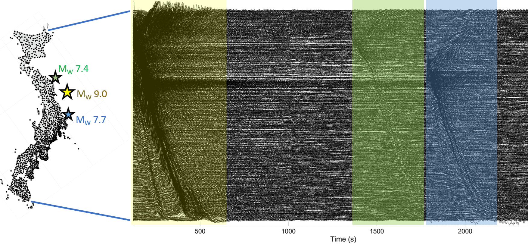
(left) A map of Japan densely covered with dots. Three stars off its eastern coast show the locations of the epicentres. (right) Graph showing eastward components of ground motion at each site. The graph resembles a bunched-up sheet, with the biggest bunches associated with the main quake (a period of up to ~600 s shown in yellow) and the two aftershocks shown in green and blue at 1500s and 2000s respectively.
Shifting eastward (left) A map of Japan showing the epicentres of the main shock (Mw 9.0) and two strongest aftershocks (Mw 7.7 and 7.4) in the Tohoku-Oki earthquake. Each black dot represents a GNSS station. (right) The observed eastward components of ground motion at each of the GNSS sites from northeast (top) to southwest (bottom) of Japan are shown in black traces, with the shaded areas representing ground motion corresponding to the main shock and the aftershocks. (Courtesy: Sunyoung Park; motion data from P Xu et al. Earth, Planets and Space 71 43 2019)

A previously unrecognized source of seismic hazard caused parts of Japan to move eastwards by up to 5 mm within minutes of the 2011 Tohoku-Oki earthquake. Conventionally, such shifts occur when seismic waves generated by rupturing tectonic plates cause the plates to slip, triggering movements of the land mass and the ocean floor. But a new study finds that in the Tohoku-Oki quake, the real culprit was waves that travelled down to Earth’s core and back – a phenomenon more usually associated with efforts to image structures deep inside the Earth.

The 2011 Tohoku-Oki quake occurred at the boundary between the Pacific plate and the North American plate, with an offshore epicentre around 130 kilometres east of Sendai. At magnitude 9, it was one of the largest recorded earthquakes in history, and it caused widespread devastation, including thousands of fatalities. The tsunami that followed exacerbated this damage, with meltdowns of three out of six nuclear reactors at the Fukushima Daiichi power station releasing radioactive caesium into the air and water and prompting a large-scale evacuation with long-term health impacts.

The earthquake was bigger than most models estimated, which compelled seismologists to examine and revise existing models of the largest possible earthquakes and their frequencies in the boundaries of tectonic plates. Instrumented records of this earthquake are still revealing new information about geophysical processes in the boundaries of tectonic plates.

Surface to core and back

In the new work, researchers led by Sunyoung Park at the University of Chicago, US studied shear waves recorded following the earthquake in Japan’s dense network of high-rate Global Navigation Satellite System instruments. Along with the expected seismic waves from the earthquake rupture, the team found so-called ScS waves that travelled thousands of kilometres through the Earth, bounced off the core and travelled back to the surface, arriving across Japan almost simultaneously 13 minutes after the main shock. “The name ScS reflects that path: S[hear] through the mantle, c for reflection at the core-mantle boundary, and then S again on the return path,” Park explains.

Although seismologists have studied ScS waves extensively, they have mostly done so for the purpose of imaging the deep Earth. “Because [ScS waves] reflect from the core-mantle boundary, they have helped constrain the depth and properties of the core-mantle boundary; the structure of the lowermost mantle; attenuation and anisotropy in the mantle; and source characteristics of large earthquakes,” Park explains.

The team’s study offers the first evidence that ScS waves can also trigger significant displacement-causing slip after an earthquake, meaning that earthquake hazard researchers may need to consider these waves to fully capture consequences of earthquake ruptures on the land as well as deep within tectonic plates.

A high-quality, high-resolution dataset

Two aspects of the Tohoku-Oki earthquake made it an incredible opportunity to study the role of ScS waves in triggering a slip event. The first is the nature of the earthquake itself. As well as releasing tremendous amounts of energy, it occurred on a shallow tectonic fault that is dipping down. This combination sent strong shear wave energy travelling nearly vertically down to the core, generating ScS waves strong enough to trigger movement in the tectonic plates.

The second was the quality and resolution of data. “Because Japan is so densely instrumented, we can look for small, coherent signals that would likely be invisible elsewhere,” Park says. “This made it a natural case in which to ask whether delayed seismic phases might trigger additional deformation.”

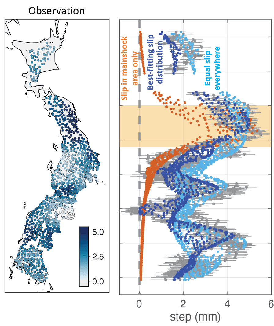
Working with Hiroo Kanamori at the California Institute of Technology (Caltech), US, and Luis Rivera at the University of Strasbourg, France, Park considered whether Earth’s elastic response to the main shock could explain Japan’s 5-mm displacement. To better understand this possibility, they calculated displacements at all the instrumented locations for many possible configurations of the earthquake rupture. However, the results did not reproduce the observed eastward motion.

At left, a map of Japan covered with dots in different shades of blue, with lightest blue representing no displacement and the darkest blue representing 5mm displacement. Large areas of Japan, especially the northeast, are dotted in dark blue. At right, a set of orange, dark blue and light blue dots representing the results of different models of displacement. The simulated data for equal slip everywhere fits the observed data better than the data for slip in main shock area only.
Competing models (left) Observed displacements in mm shown with coloured dots at each GNSS site across Japan. (right) The calculated displacement that would have occurred for slip only in the main shock area (orange dots), equal slip across the tectonic plates (light blue dots) and best fit slips corresponding to the observed displacement (dark blue dots). (Courtesy: Sunyoung Park)

The researchers then simulated possible slip scenarios across the tectonic plate interfaces, hoping to better characterize the levels and spatial extent of the slip that caused the eastward displacement. “The inferred slip event likely involved interfaces where the Pacific plate subducts beneath the Okhotsk Plate, and where the Philippine Sea plate subducts beneath the Eurasian plate,” Park says. Exactly how far this slip propagated, however, is still unknown because of the paucity of instrumented locations beyond Japan.

A slow-motion slip

Although the most memorable earthquakes and tsunamis are the ones that manifest havoc on Earth’s surface, the tectonic plates underneath are in perpetual but slow motion. At higher depths, these slow-moving plates produce earthquake events that unfold over days or weeks. Such events are called slow-slip or silent earthquakes and are important for accumulating and releasing stress as part of the earthquake cycle.

Rather than triggering a fast earthquake rupture, the ScS waves from the Tohoku-Oki quake appear to have set off a slow slip event spread over a very large area at intermediate depths of 20–60 km. This is the depth range where seismologists commonly observe silent earthquakes, and it provides avenues for understanding the dynamic processes that impact the earthquake cycle. This continuous flux in Earth’s deeper layers is a source of curiosity for many seismologists, including Park.

“A broader motivation for me is a general interest in deep-shallow interaction in the Earth,” Park tells Physics World. “I am especially interested in cases where processes or wave propagation involving the deep interior can influence faulting and deformation in the shallow lithosphere or vice versa.”

The researchers report their findings in Science.

The post Seismic waves reflected from Earth’s core moved parts of Japan 5 mm east appeared first on Physics World.

❌