NASA pushed its Deep Space Network beyond its limits during the Artemis I mission nearly four years ago. The global array of deep space communications antennas couldn't keep up with the routine demands of 40 robotic science missions and the extraordinary surge required by NASA's Orion space capsule as it flew around the Moon.
The experience in late 2022 reduced or delayed downlinks from several high-profile science missions, including the James Webb Space Telescope and Mars rovers, as the data-hungry Artemis I mission took priority on NASA's communications network. And that was before the first Artemis mission with astronauts onboard. When Artemis II launched April 1, NASA called upon the Deep Space Network (DSN) again to connect Mission Control to the Orion capsule as it soared more than a quarter of a million miles from Earth.
With a crew of four flying inside the spacecraft, the agency's appetite for data from Orion on Artemis II was even higher than it was on Artemis I. But at a little more than nine days, the Artemis II mission was shorter than the 25 days Artemis I spent in space, helping alleviate the communications overload. Artemis I also launched 10 small CubeSats into deep space, many of which required tracking and telecom services from the DSN. Artemis II carried fewer CubeSats.
Very little is known about funerary practices in Iron Age Britain, since few human remains have survived. However, the environment in northwest Scotland is more conducive to preserving bone from that period. Archaeologists have previously noted evidence of postmortem manipulation of human remains, such as mummification, and of modifying human bones into tools or decorative artifacts. Now a new paper published in the journal Antiquity describes evidence of postmortem brain removal in remains from that region, as well as sharpened limb bones, possibly for use as tools.
The remains in question were found in 2000 at a burial cairn in Loch Borralie, near the most northwest tip of the Scottish mainland, after erosion revealed a human cranium. The excavated remains belonged to two individuals: one an adult female and the other a juvenile of (at the time) indeterminate sex; the cranium belonged to the latter. The authors of the new paper conducted a fresh osteoarchaeological analysis as well as multi-isotope and ancient DNA analysis. Radiocarbon dating of molar teeth from both sets of remains placed their deaths as occurring between 50 BCE and 70 CE.
In the case of the female individual, the authors noted an unusual break at the base of the cranium that likely occurred near the time of death. It's the kind of fracture that one gets from high-velocity impacts, including vehicular collisions, sporting accidents, falls, assaults, or even long-drop hanging. But the known forensic patterns observed in the aforementioned scenarios don't exactly match the pattern of the Iron Age cranium, leading the authors to conclude that it likely resulted from a targeted impact. They also noted perimortem fractures on both scapulae.
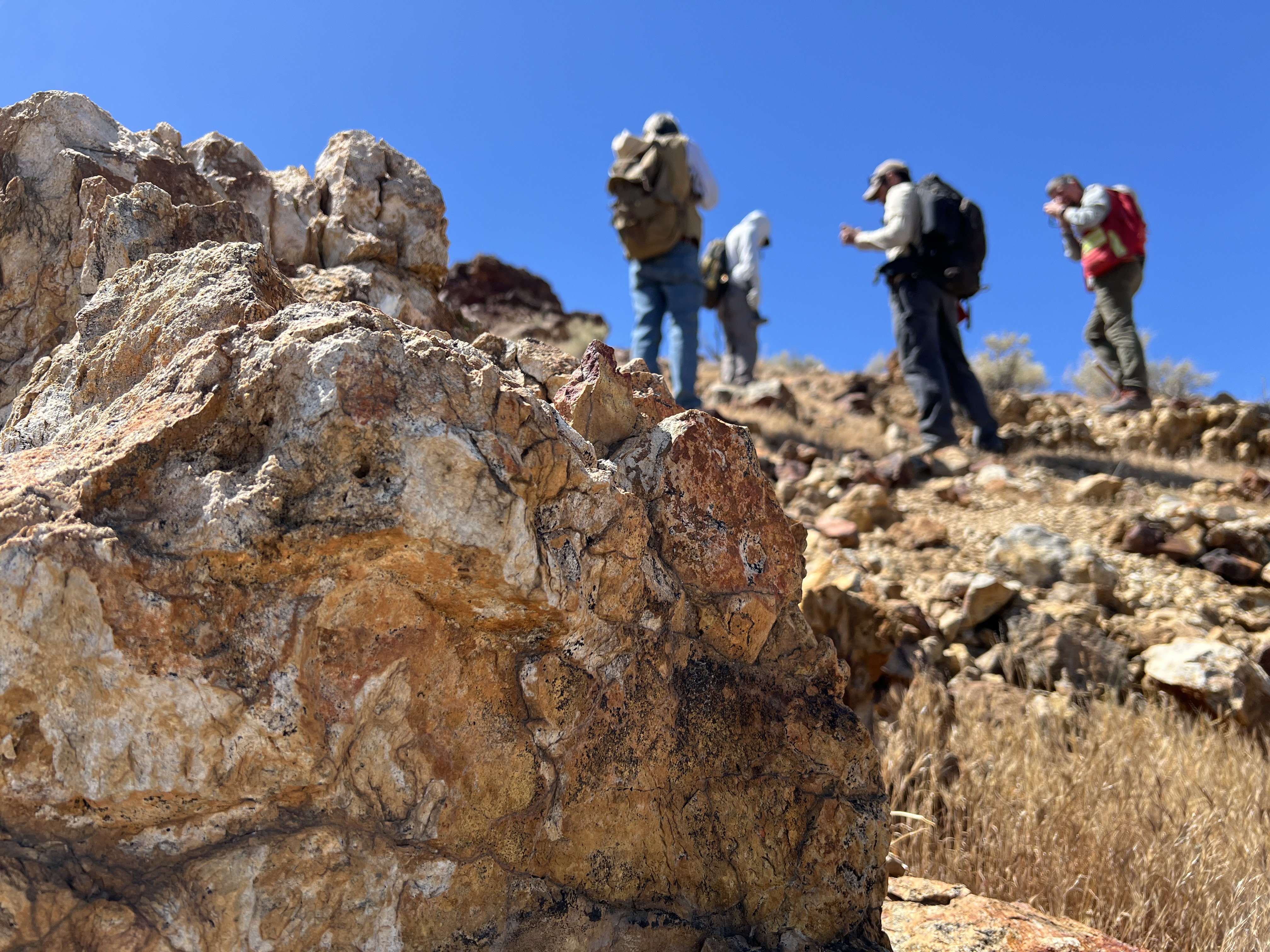
Geologists recently converged on a site near Barstow, California, to ground-truth a mineral discovery made on public land by a NASA JPL sensor flying aboard a plane overhead.
NASA/JPL-Caltech
Equipped with rock picks and hand lenses, a team of geoscientists deployed to the Mojave Desert recently to investigate a tantalizing “fingerprint” detected by a NASA sensor. Their target: a cache of topaz hiding in plain sight.
The geologists weren’t searching for gem-grade treasure. Rather, the presence of topaz could hint at a more valuable deposit below of something known as porphyry copper.
One of the world’s primary sources of copper, these deposits are left behind when magma and hot water from deep underground course through Earth’s crust, chemically transforming the surrounding rock. This tends to occur where one tectonic plate dives below another, known as a subduction zone, such as the North American Cordillera, which stretches from the Canadian Rockies to western Mexico.
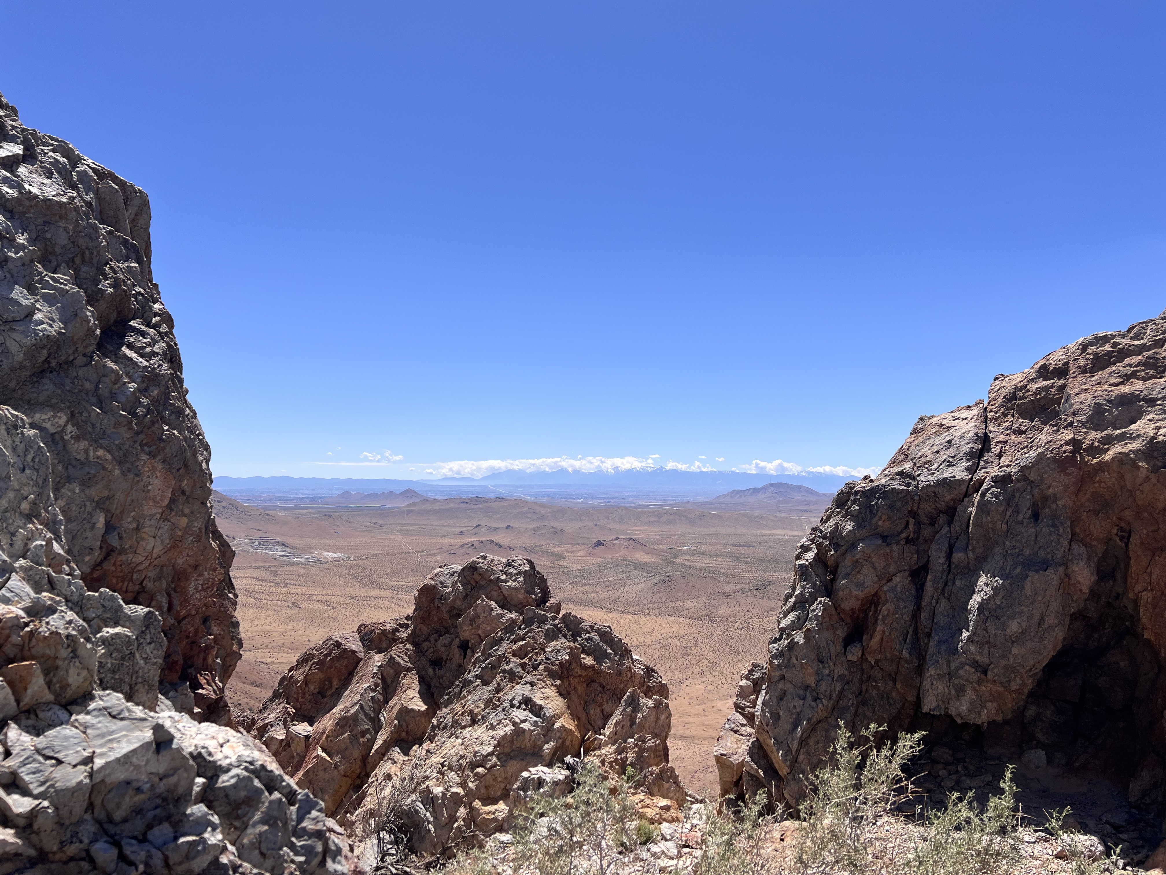
California’s high desert stretches below a bright spring sky in April 2026. NASA and USGS scientists are using airborne remote sensing to home in on potential sources of critical minerals here and across the Western U.S.
NASA/JPL-Caltech
In addition to copper — the third most used metal in the world after steel and aluminum — the deposits can hold other critical minerals like molybdenum and tellurium, which are used in everything from steelmaking to solar panels. Finding the deposits isn’t easy. Geologists look for topaz because it forms under the same volcanic conditions.
For the team in the Mojave, the goal was to collect more evidence. That would require boots on the ground and a heavy bag of samples. The scientists who converged on the site included three experts from the U.S. Geological Survey (USGS) and Robert Green of NASA’s Jet Propulsion Laboratory in Southern California.
“What we’re doing out here is geologic CSI,” said Green, referring to the investigative TV show, as he split open a weathered red rock to expose a sparkling core. “We’re looking for clues to reconstruct what happened here.”
Three-dimensional image cubes illustrate the volume of data captured by NASA imaging spectrometers. The front face shows an aerial view of the Mojave Desert. The colorful side panels reveal what no eye or camera can detect: the spectral fingerprints of minerals present in every pixel.
NASA/JPL-Caltech
Next-generation mineral mapping
The sensor that detected the topaz deposit on public land near Barstow, California, was built at JPL. Called AVIRIS, short for Airborne Visible Infrared Imaging Spectrometer, it analyzes reflected sunlight and can be used to identify chemicals and minerals by their unique spectral fingerprint. The technology was pioneered in the early 1980s by a team that included Green, and space-hardened versions have explored the Moon, Mars, and other rocky bodies in the solar system in the decades since.
While its cousins study distant worlds aboard spacecraft, the AVIRIS line of sensors is advancing Earth science from aircraft. The latest model, AVIRIS-5, recently took to the skies for the first time as part of the NASA-USGS Geologic Earth Mapping Experiment (GEMx). The goal of GEMx is to identify sources of critical minerals across the American West, including in the waste rock of active and legacy mines. It is led by the USGS as part of its larger, nationwide initiative.
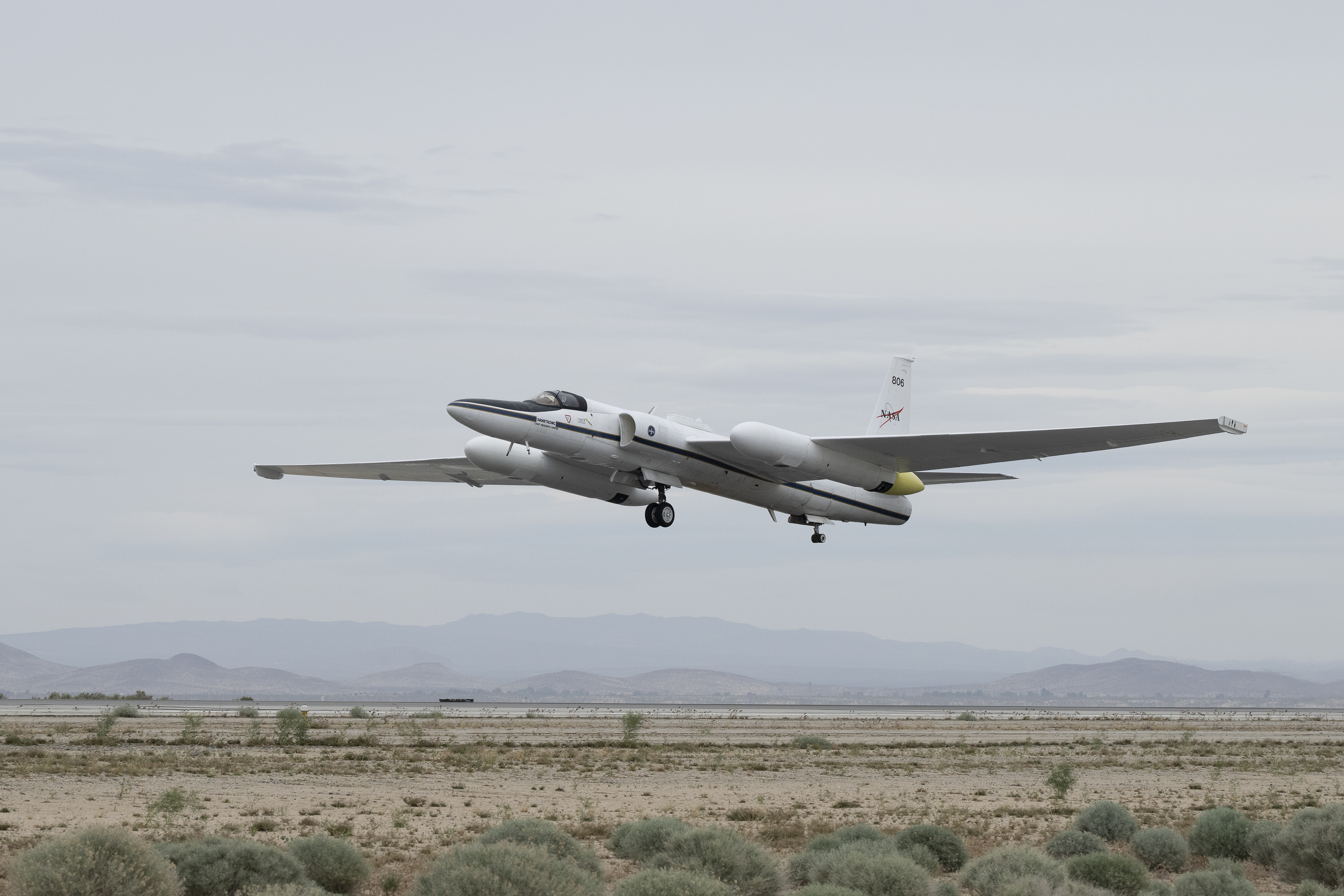
Carrying next-generation sensors, a high-altitude NASA ER-2 aircraft takes off from the agency’s Armstrong Flight Research Center in Edwards, California, on March 31, 2026, to support the GEMx mineral mapping campaign.
NASA/Carla Thomas
Since 2023, GEMx flights have covered more than 386,000 square miles (1 million square kilometers) of American soil, including most of California.
Ground-truthing the sensor data can entail hot field work, scrambling over steep crags to uncover samples for lab analysis. While testing has confirmed the topaz discovery, determining if the Mojave site overlies a porphyry copper deposit will require intensive investigation using ground-penetrating equipment. But the AVIRIS finding shows how advanced NASA airborne sensing can help lead geologists to the metaphorical needle in a haystack, even in heavily explored Southern California.
“People have been prospecting this area for generations,” said Erik Tharalson, a USGS geologist. “But there’s a lot more to discover.”
High flyer
From the beginning, the GEMx mineral mapping campaign has been enabled by one of the highest-flying aircraft in NASA’s fleet: the ER‑2. It deployed on March 31 from NASA’s Armstrong Flight Research Center in Edwards, California, to Colorado Springs Airport in Colorado.
“We deployed to Colorado Springs to maximize flight time for data collection needed in Colorado, Utah, New Mexico, Arizona, and Texas,” said John McGrath, ER‑2 project manager at NASA Armstrong.
By the conclusion of this deployment on June 5, the aircraft had completed 26 flights totaling more than 125 hours. Soaring at about 65,000 feet, the ER-2 can fly at high altitudes that allow it to collect broad‑area, high‑resolution spectral measurements in a single pass, supporting researchers studying mineral composition and surface processes.
In 2025, the aircraft flew 36 science missions, collecting more than 7 billion measurements over 200 flight hours. The data has contributed to the largest airborne surface mineralogy dataset gathered in a single NASA-USGS campaign.
The GEMx survey is led and funded by the USGS Earth Mapping Resources Initiative. Earth MRI is modernizing mapping the nation’s surface and subsurface to find new, critical, and other minerals. It is a partnership effort with 45 state geological surveys, federal agencies, private industry, tribes, universities, and others. The initiative will capitalize on both the technology developed by NASA for spectroscopic imaging, as well as the USGS expertise in analyzing the datasets, conducting field work, and deriving critical mineral information from them.
Elon Musk, on the verge of becoming the world's first trillionaire, is whipping up anti-immigration tensions amid ongoing riots in Belfast, Northern Ireland. Following a knife attack in the city on Monday, Musk declared support for Restore Britain, a hard-right populist political party that advocates for large-scale migrant deportation in the UK. He reposted statements from party leader Rupert Lowe calling for "a vast number of people" to be forced out of the country, as well as a promise from Lowe to "prosecute officials and politicians who knowingly placed dangerous third world savages in our communities." "This is the way," Musk added to …
Geologists recently converged on a site near Barstow, California, to ground-truth a mineral discovery made on public land by a NASA JPL sensor flying aboard a plane overhead.
NASA/JPL-Caltech
Equipped with rock picks and hand lenses, a team of geoscientists deployed to the Mojave Desert recently to investigate a tantalizing “fingerprint” detected by a NASA sensor. Their target: a cache of topaz hiding in plain sight.
The geologists weren’t searching for gem-grade treasure. Rather, the presence of topaz could hint at a more valuable deposit below of something known as porphyry copper.
One of the world’s primary sources of copper, these deposits are left behind when magma and hot water from deep underground course through Earth’s crust, chemically transforming the surrounding rock. This tends to occur where one tectonic plate dives below another, known as a subduction zone, such as the North American Cordillera, which stretches from the Canadian Rockies to western Mexico.
California’s high desert stretches below a bright spring sky in April 2026. NASA and USGS scientists are using airborne remote sensing to home in on potential sources of critical minerals here and across the Western U.S.
NASA/JPL-Caltech
In addition to copper — the third most used metal in the world after steel and aluminum — the deposits can hold other critical minerals like molybdenum and tellurium, which are used in everything from steelmaking to solar panels. Finding the deposits isn’t easy. Geologists look for topaz because it forms under the same volcanic conditions.
For the team in the Mojave, the goal was to collect more evidence. That would require boots on the ground and a heavy bag of samples. The scientists who converged on the site included three experts from the U.S. Geological Survey (USGS) and Robert Green of NASA’s Jet Propulsion Laboratory in Southern California.
“What we’re doing out here is geologic CSI,” said Green, referring to the investigative TV show, as he split open a weathered red rock to expose a sparkling core. “We’re looking for clues to reconstruct what happened here.”
Three-dimensional image cubes illustrate the volume of data captured by NASA imaging spectrometers. The front face shows an aerial view of the Mojave Desert. The colorful side panels reveal what no eye or camera can detect: the spectral fingerprints of minerals present in every pixel.
NASA/JPL-Caltech
Next-generation mineral mapping
The sensor that detected the topaz deposit on public land near Barstow, California, was built at JPL. Called AVIRIS, short for Airborne Visible Infrared Imaging Spectrometer, it analyzes reflected sunlight and can be used to identify chemicals and minerals by their unique spectral fingerprint. The technology was pioneered in the early 1980s by a team that included Green, and space-hardened versions have explored the Moon, Mars, and other rocky bodies in the solar system in the decades since.
While its cousins study distant worlds aboard spacecraft, the AVIRIS line of sensors is advancing Earth science from aircraft. The latest model, AVIRIS-5, recently took to the skies for the first time as part of the NASA-USGS Geologic Earth Mapping Experiment (GEMx). The goal of GEMx is to identify sources of critical minerals across the American West, including in the waste rock of active and legacy mines. It is led by the USGS as part of its larger, nationwide initiative.
Carrying next-generation sensors, a high-altitude NASA ER-2 aircraft takes off from the agency’s Armstrong Flight Research Center in Edwards, California, on March 31, 2026, to support the GEMx mineral mapping campaign.
NASA/Carla Thomas
Since 2023, GEMx flights have covered more than 386,000 square miles (1 million square kilometers) of American soil, including most of California.
Ground-truthing the sensor data can entail hot field work, scrambling over steep crags to uncover samples for lab analysis. While testing has confirmed the topaz discovery, determining if the Mojave site overlies a porphyry copper deposit will require intensive investigation using ground-penetrating equipment. But the AVIRIS finding shows how advanced NASA airborne sensing can help lead geologists to the metaphorical needle in a haystack, even in heavily explored Southern California.
“People have been prospecting this area for generations,” said Erik Tharalson, a USGS geologist. “But there’s a lot more to discover.”
High flyer
From the beginning, the GEMx mineral mapping campaign has been enabled by one of the highest-flying aircraft in NASA’s fleet: the ER‑2. It deployed on March 31 from NASA’s Armstrong Flight Research Center in Edwards, California, to Colorado Springs Airport in Colorado.
“We deployed to Colorado Springs to maximize flight time for data collection needed in Colorado, Utah, New Mexico, Arizona, and Texas,” said John McGrath, ER‑2 project manager at NASA Armstrong.
By the conclusion of this deployment on June 5, the aircraft had completed 26 flights totaling more than 125 hours. Soaring at about 65,000 feet, the ER-2 can fly at high altitudes that allow it to collect broad‑area, high‑resolution spectral measurements in a single pass, supporting researchers studying mineral composition and surface processes.
In 2025, the aircraft flew 36 science missions, collecting more than 7 billion measurements over 200 flight hours. The data has contributed to the largest airborne surface mineralogy dataset gathered in a single NASA-USGS campaign.
The GEMx survey is led and funded by the USGS Earth Mapping Resources Initiative. Earth MRI is modernizing mapping the nation’s surface and subsurface to find new, critical, and other minerals. It is a partnership effort with 45 state geological surveys, federal agencies, private industry, tribes, universities, and others. The initiative will capitalize on both the technology developed by NASA for spectroscopic imaging, as well as the USGS expertise in analyzing the datasets, conducting field work, and deriving critical mineral information from them.
The Weather Company announced an "enhanced allergy experience" now available through its The Weather Channel app designed to help allergy sufferers better understand when their symptoms might flare up, and what's causing them. While the app already provides static pollen counts, its "Health & Wellness" section is being expanded to take into account other factors such as how changing weather conditions could result in you experiencing more symptoms despite the counts not actually rising.
The new features now available in the free version of The Weather Channel app include "weather aggravator insights" that analyze how conditions like high wi …
Every day, people rely on computer chips to keep sensitive information safe. These tiny pieces of hardware help protect everything from online banking details and personal data to government and military secrets. But new research suggests that some chips could contain hidden threats that are almost impossible to detect using current security methods. Researchers from […]
The upcoming loss of a deep-ocean monitoring system is triggering deep anxiety in Alaska, the nation’s top fish-producing state, where temperatures are warming twice as quickly as the global average.
The National Science Foundation announced plans in May to decommission the Ocean Observatories Initiative, a nearly $368 million network of scientific instruments that tracks ocean chemistry, wave action, water temperature, salinity, and a host of other metrics.
The real-time information from these ocean observatories helps scientists, fishery managers, coastal hazard planners, and even the military plan and prepare for the future. Whether that’s calculating how much fish can be harvested or when a marine heatwave or giant wave action may be occurring, the data is used by a plethora of sources.
We tend to view ourselves and the complex cells that build us as a distinct branch of the tree of life from the compact, seemingly featureless cells of bacteria and archaea. But we've found that our genome is actually a hybrid, a mish-mash of genes from bacteria and archaea, along with some that have evolved in our own lineage.
Scientists gradually settled on a simple explanation for this: the first complex cells were the product of a fusion between archaeal cells and bacteria, with the bacteria ultimately evolving into the mitochondria, a chemical-power-generating structure that still retains a bit of its own genome. Over time, many of the other bacterial genes were transferred to the nucleus of what was becoming what we now call a eukaryote, intermingling with the archaeal genes there.
But a new study has taken a careful look at some of the genes shared by all eukaryotes and comes to the conclusion that the reality is a little more complicated and that there were several waves of gene transfers from bacteria. The big picture of a merger between bacteria and archaea is still right, but it was only part of a picture where gene transfers among species were commonplace.
The Cozumel dwarf fox, a rare species previously known only from secondhand reports and fossil records, has been discovered alive on Cozumel, a small Caribbean island off the eastern coast of the Yucatán Peninsula.
Researchers published the announcement in Neotropical Biology and Conservation, describing the rescue and identification of the rare dwarf fox before it was released back into the wild. They caution that this rare species, previously believed extinct, faces extreme danger from a host of threats.
The Cozumel Dwarf Fox
As one of the rarest canids on the planet, the species had never before been documented alive by scientists. The Cozumel dwarf fox (Urocyon sp.) is a close relative of the gray fox (Urocyon cinereoargenteus), which is found on the Mexican mainland. After several millennia of isolation on the island—possibly predating Maya settlement—the Cozumel fox underwent insular dwarfism, evolving to only 60–80% the size of its mainland relatives.
Evidence for the animal has been remarkably scarce, and while subfossil remains provided conclusive proof that the species once existed, there had not even been a secondhand report since 2001, leading many researchers to assume it was extinct.
That changed on September 14, 2023, when members of the public reported a disoriented fox along a coastal highway near kilometer marker 29.
Responders from the Fundación de Parques y Museos de Cozumel recovered the animal and cared for it for three days while monitoring its health. On September 17, 2023, the fox was released into the Laguna Columbia State Reserve, where it would be protected from traffic and other hazards.
The sighting marks the first time the Cozumel fox has been formally documented by scientists and recognized as taxonomically distinct.
The Cozumel dwarf fox, believed long extinct, was finally recorded by scientists. Credit: Rafael Chacón
Cozumel Fox Habitat
Although the sparse evidence of these creatures may not be enough to conclusively map their habitat, the researchers have some idea where the Cozumel fox typically resides.
“Historical sightings have been concentrated around the community of El Cedral and near the entrance of Punta Sur Ecological Park, which is where this photographic record also took place,” lead author Travis Bayer of Pathos Wildlife told The Debrief. “No sightings have ever been observed further north than El Cedral, which leads us to believe that may be the extent of their range on the island, which would also be very concerning due to the already limited space on an island.”
“If their home ranges are restricted to the Southern end of the island, they may have home ranges around 100 km2,” Bayer continued. “If they associate with only wetland/mangrove habitats, the size gets considerably smaller and more concerning for their conservation, as those habitats mainly only occur along the coastline and are at high risk for development for restaurants and resorts.”
Staying Hidden
Given that Cozumel is a popular tourist destination known for its beaches and resorts, it may seem surprising that an animal the size of a fox could remain undetected for so long. Bayer says part of the explanation lies in the island’s difficult terrain and the species’ elusive behavior.
“Cozumel is home to many different terrestrial ecosystems, many of which are not easily accessible either,” Bayer explained. “Habitats like the mangrove forests and wetlands are almost impenetrable to us, but to a fox, easily traversable.”
Image Credit: Rafael Chacón
“Also, not that many people are out there looking for this animal, as the public awareness of it was extremely low, and the scientific investment was limited to one primary publication and a few brief mentions in others,” he added.
Additionally, the combination of grey foxes’ typical elusiveness, their nocturnal habits, and the highway cutting through their habitat being closed at night all combine to make the species easy to miss.
Preserving the Cozumel Fox
“In collaboration with a team of local biologists, led by Rafael Chacón, we have begun developing an emergency conservation action plan for the Cozumel fox aimed at locating remaining individuals, estimating population size, identifying critical habitat, and determining immediate threats,” Bayer said.
Ensuring that the species does not disappear again is now a top priority. Researchers consider the fox critically endangered, with its limited habitat threatened by development, invasive species, and natural disasters.
Several introduced animals also pose significant risks. These include invasive boas released during a 1971 film production that have since spread across the island. Domestic dogs and cats may also threaten the fox through competition, predation, or disease transmission. In addition, predators such as ocelots and margays were introduced as exotic pets before eventually being released into the wild.
“Using thermal drone surveys, large-scale camera trap networks, and other advanced monitoring technologies, we aim to rapidly generate the data needed to guide immediate conservation intervention,” Bayer said. “Simultaneously, we are collecting the evidence necessary to formally describe the animal as a new and distinct species deserving of critically endangered recognition and legal protections.”
“One of the most important takeaways from this research is that species can quietly disappear without the world even realizing they are gone,” Bayer concluded.
“We often think extinction is something dramatic and obvious, but in reality, it can happen gradually and silently, especially for rare species living in remote or understudied habitats.”
Ryan Whalen covers science and technology for The Debrief. He holds an MA in History and a Master of Library and Information Science with a certificate in Data Science. He can be contacted at ryan@thedebrief.org, and follow him on Twitter @mdntwvlf.
With summer's return, I'm again reminded of my limits as I head into the great outdoors: I can put up with a heavy, uncomfortable backpack, bug bites, mud, and even bland dehydrated food, but I will not forsake my morning brew.
I've tried every imaginable coffee gadget in my half-century of camping. These range from simple drip systems when ultralight backpacking, an AeroPress when not weighing every gram, French press plungers when assisted by bicycle, and small countertop coffee makers when adventuring by van. Yet I keep returning to handheld espresso makers whenever possible for reasons of taste, convenience, and - let's face it - gadget …
Rising seas could turn mangroves from carbon-storing climate allies into unexpected carbon emitters. Mangroves are among the most effective natural systems for capturing and storing carbon, but new research suggests that rising sea levels could significantly reduce that benefit and may even cause these coastal forests to release carbon in the future. Made up of [...]
Ancient asteroid impacts may have done more than reshape Earth’s surface. For decades, asteroid impacts have been viewed mainly as agents of destruction. But on the young Earth, they may have done something far more surprising: helped create some of the planet’s first habitable environments. A new study from Southwest Research Institute (SwRI) suggests that [...]
A team of engineers at the Massachusetts Institute of Technology (MIT) has developed a groundbreaking imaging system capable of capturing detailed 3D images through even the murkiest waters.
The new technology, which harnesses the power of single-photon detectors and advanced computational algorithms, is poised to significantly enhance underwater exploration, search-and-rescue operations, and environmental monitoring.
Breakthrough in underwater imaging
Traditional methods for underwater imaging, such as sonar and optical cameras, have struggled to provide clear visuals in turbid environments. Particles in the water scatter light, making it nearly impossible to see beyond a few meters (about 6.5 feet) in highly cloudy conditions.
However, the new MIT system can generate sharp, three-dimensional images from distances up to 20 meters (about 65.6 feet) in water with extremely high turbidity.
How the technology works
At the core of the system is a pulsed laser that emits bursts of light into the water. As these pulses bounce off objects and return, they are detected by a highly sensitive single-photon avalanche diode (SPAD) array.
Each photon’s journey is recorded, allowing the system to calculate the precise distance and shape of submerged objects, even when only a handful of photons make it back through swirling sediment.
To interpret the faint signals, the team developed new computational algorithms that reconstruct 3D scenes from the sparse, scattered data. The result: detailed images that would be impossible for conventional cameras to achieve in similar conditions.
Potential applications and future impact
According to the MIT team, this imaging breakthrough could revolutionize a range of underwater activities. Search and rescue teams could locate lost objects or people more quickly in cloudy lakes or coastal waters. Marine biologists could study habitats previously hidden by sediment. Archaeologists might uncover ancient shipwrecks buried beneath layers of silt.
The technology could also be invaluable for inspecting underwater infrastructure, such as pipelines, bridges, or dams, where safety and clarity are paramount.
Testing and results
The research team tested their prototype in a specially designed tank filled with water so murky that standard cameras could not see beyond 3 centimeters (about 1.2 inches). With their new system, they successfully imaged objects at distances up to 20 meters (65.6 feet), a feat previously thought unattainable in such conditions.
The system is also energy efficient, requiring less power than traditional active imaging methods, and can be made compact enough for use on underwater drones or remotely operated vehicles.
Looking ahead
While the current prototype is a significant leap forward, the researchers are already working to refine the technology, aiming to increase imaging speed and resolution. They envision future versions integrated into autonomous underwater vehicles for continuous monitoring of oceans, lakes, and rivers.
MIT’s new imaging system represents a major advance in overcoming the challenges of underwater visibility and could open up a new era of aquatic discovery and safety.
fjo3 shares a report from The Guardian: Tests reveal that when people are ambling about, they have a natural tendency to turn to the left and walk in an anticlockwise direction. "If you simply ask someone to start walking, whether they are wandering around a museum, a supermarket, or even an empty room, it is surprisingly likely that they will drift counterclockwise," said Dr Inaki Echeverria Huarte at University of Navarra in Spain.
As with many critical discoveries in science, the revelation owes a debt to serendipity. During the pandemic, the researchers ran experiments to see how many people could share a space while keeping a safe distance. On reviewing the video, they noticed that crowds overwhelmingly walked in an anticlockwise direction. The surprise set in motion an entire research project. The scientists conducted a series of experiments in which individual pedestrians or small crowds roamed around enclosed spaces. Time and again, the researchers observed the tendency to walk in an anticlockwise direction.
Suspecting that cultural norms might play a role, the team joined forces with Dr Claudio Feliciani at the University of Tokyo. He found the same results in Japan. The finding held when the researchers accounted for people being right-handed, right-footed and right-eye dominant, and was seen in both male and female walkers. The only difference they spotted was a more pronounced bias in children. "Each of us carries a small personal bias to turn slightly to one side, and when many people share a space, those tiny biases add up into a net counterclockwise rotation," said Echeverria Huarte. Researchers think the tendency may be tied to biomechanics: people are not perfectly symmetrical, and the way the brain processes sensory information and coordinates muscles may gently tip walkers toward one side. Right-side dominance may also play a role, especially in running, where anticlockwise movement puts more internal force on the right side of the body and may feel more natural to right-leg-dominant athletes.
"We have tested several ideas and the bias stubbornly keeps showing up, so the exact mechanism is still an open question," said Echeverria Huarte.
The findings have been published in Nature Communications.

 Login