Pelicans have resided in St James’s Park, London for 360 years. But the current flock have been a summer sensation due to the first hatching of chicks in the park’s history.
Pelican breeding in zoos is demanding for these birds, because the right environmental and social conditions need to come together. Rather than simply being comfortable, the birds need to encounter and respond to cues that stimulate courtship, nesting and reproduction.
This unusual nesting at St James’s Park provides an interesting example of how responding to biologically relevant stressors is a positive part of an animal’s life. Multiple factors are likely to have contributed to the pelican nesting. The heatwave, the flock’s dynamics and the compatibility of the individual birds seem to have created the right conditions for the first time in centuries.
In my recent research, I evaluated the importance of positive stress to zoo and aquarium animal welfare and found it is crucial for the wellbeing of captive animals.
Researchers call the beneficial response to a stressor, “eustress” – eu being the Greek prefix for good.
Courtship, reproduction and chick-rearing are all natural stressors. Priorities change, energetic and physical needs alter, and adults spend more time on offspring. This stress, however, is not necessarily bad. For example it can provide learning opportunities and enhance the animals’ behavioural repertoire.
As we learn more about what good animal welfare is, it is becoming clear that meaningful challenges which reflect an animal’s natural ecology help them have more autonomy over how they live. Eustress also helps animals cope better with averse situations.
Zoos do not need dramatic changes to provide these experiences. Small challenges can be built into everyday care: food can be hidden in different locations, or new scents and natural materials introduced. Animals can encounter new ground materials and surfaces (such as soil, bark and sand), changes to ropes or branches, or vegetation that naturally changes with the seasons. Enrichment can also encourage animals to explore different parts of their existing enclosure or use familiar resources in new ways.
Variation is key. If food always appears in the same place, at the same time and in the same way, there is little need for an animal to make decisions or adapt.
Many zoos already provide these opportunities. The next step is to think more deliberately about the challenge itself: is it meaningful, does the animal have a choice about engaging, and can it successfully overcome it? The aim is not to make life unnecessarily difficult but for animals encounter novelty or problems they can solve.
Rather than simply giving an animal what it needs to survive, we should provide opportunities for the animal to use their skills and make decisions.
What might this look like at your local zoo then? Meerkats (Suricata suricatta) are one example. Wild meerkats do not encounter their food neatly presented in a bowl. They need to sniff, dig and investigate their surroundings, while members of the mob keeps watch for danger.
Finding food is also a social challenge for these animals. Young meerkats learn about unfamiliar foods by observing and interacting with more experienced adults. Older meerkats help youngsters acquire important food handling skills.
Zoos can recreate elements of these challenges by scattering or hiding food, providing a sandy floor that encourages digging and creating elevated lookout points. Likewise, zoos can encourage social opportunities by providing complex feeding experiences where animals forage together. A 2021 study found that zoo meerkats retain the sentinel behaviour seen in their wild counterparts, suggesting that opportunities to perform these sort of activity remains important even when predators are absent.
The same principles apply underwater. Common clownfish (Amphiprion ocellaris) also encounter environmental and social challenges. On coral reefs, clownfish forage in a complex three-dimensional environment and depend on a host anemone for protection. They live in a strict social hierarchy. The largest fish is the dominant female, followed by the breeding male and then smaller, non-breeding fish. This social group is known as as a “queue”, as subordinate fish can move up through the hierarchy. In the aquarium, recreating this social group by housing a shoal of clownfish around the correct host anemone species allows for more choice and for fish to express a richer behavioural repertoire.
This brings us back to St James’s Park’s pelicans. Successful breeding has introduced perhaps the most natural challenge of all. Finding a partner and rearing young to maturity requires animals to change how they spend their time and respond to altered demands. When animals work for a reward, scientists call this contrafreeloading.
However, zoo animals can experience negative stress when a stressor is prolonged, overwhelming, unnatural or beyond their control. Examples can be excessive noise, incorrect climate conditions or being unable to retreat from something they find threatening.
The lesson for zoos is a good life should not necessarily be an entirely effortless one. Welfare is enhanced when animals can express behaviour their evolutionary history has equipped them to perform. Eustress is not giving every zoo animal the same kind of “challenging enrichment”. The challenge needs to make biological sense for that particular species.
If you’re thinking about moving house or just feeling nosy about your neighbours, your first port of call may be an online property marketing site: Rightmove and Zoopla in the UK, Zillow in the US or Magic Bricks in India.
They offer 3D plans of their properties and a video walkthrough, sometimes with added interactive tools. It all seems very modern – yet it turns out, at least one pioneering London estate agent was offering its clients 3D visual walkthroughs long before the advent of commercial photography.
In the UK, estate agents came into being as a specialised profession in the mid-19th century, as rapid urbanisation and greater social and geographic mobility led to a dramatic increase in the demand for housing.
But in this pre-photography era, how did the Victorian era’s newly monied see what they could buy with their gains from trade or industry? One high-end London estate agent, Brooks & Green, came up with a novel answer.
In 1838, the year of Queen Victoria’s coronation, this Old Bond Street estate agent began advertising an early form of immersive visual technology called a “cosmorama”, to offer prospective buyers a virtual tour of the properties it was selling.
A cosmorama involved looking at paintings or artists’ prints through a large convex lens, which magnified the image and enhanced the perspectival depth, creating a basic 3D effect.
A blackened square frame between the lens and picture hid the edges – enhancing the viewer’s sense of looking at a large scene through an extended opening. Clever lighting effects further enhanced the depth and immersive effects.
To create this cosmoramic view, a skilled artist would have had to visit the estate to prepare the sketches. For 20 years, Brooks & Green promoted its “cosmoramic gallery” as a proto-version of a digital walkthrough. This was nearly 50 years before photography was widely used to advertise property.
The estate agent advertised heavily in the London press. An 1842 advert claimed its office property gallery included “several hundred views of different estates”. Prospective buyers of one property were promised an “aerial perspective, the site and architectural elevation of a mansion, the local scenery and features of a park [and] ornamental grounds”.
The viewing experience of the cosmorama supposedly offered much more realism and detail than a written prospectus – without rich London buyers having to travel miles to inspect the property in question.
But this service was definitely not available to ordinary families. Only high-value mansions and estates were valuable enough to be visualised in this way. Entrance to the Brooks & Green gallery was supposedly free, but you needed an admission card – probably granted only to those who looked like they had suitably deep pockets.
For the first half of the 19th century, the cosmorama was one of the most common forms of visual show across Europe and the Americas. It was first revealed at a Paris exhibition in 1808 by the French showman Abbot Constant Gazzera. His success led to many more exhibitions throughout Europe during the 1820s and ‘30s.
In London, the Cosmorama Rooms opened in 1821 at 29 St James’s Street, moving to Regent Street in 1823. The gallery became one of the established London attractions for over 30 years. With Regent Street only a mile from Old Bond Street, it may have prompted an ambitious Brooks & Green employee to have the idea of using this innovation to market its property.
Also shown across Europe in pleasure gardens, popular science institutions, retail bazaars and fairgrounds, the cosmorama was successful because urbanisation and population growth had created a critical mass of middle-class audiences. It offered a new kind of immersive visual exhibition, reaching audiences who would never visit a fine-art gallery.
Cosmorama means “views of the world” in Greek. It was mainly used to display picturesque landscapes, renowned European sites and striking architectural interiors – such as the eruption of Mount Vesuvius, the canals of Venice or the interior of Saint Peter’s Basilica in Rome. The interest in this device reflected the public’s growing desire to be cultivated, and to learn about the wonders of the wider world.
Fascination with 3D worlds
But the cosmorama is just part of the story of immersive pictorial entertainment from the early 19th century. Other popular technologies included peepshows, panoramas and dioramas, all of which offered users a sense of virtual travel.
Panoramas were large circular paintings – the Imax cinema of the age – and dioramas were illusionistic spectacles created from 3D models. At the same time, itinerant exhibitors of peepshow boxes travelled the country’s fairgrounds displaying scenes of national events and sensational murders. Picturegoing had become part of everyday life.
I came across the Brooks & Green adverts for its cosmorama in my research for a historical project led by the Universidade Lusófona in Lisbon, which has mapped cosmorama exhibits across Europe and beyond. In all, Curiositas: Peeping Before Virtual Reality has catalogued more than 650 cosmoramas in Portugal, Spain and the UK.
Many more of these devices were exhibited in countries as far apart as North America, Brazil, Cuba and Australia. The famous US showman P.T. Barnum installed a cosmoramic gallery in his American Museum in New York.
The cosmorama was ultimately superseded by the stereoscope, which also created a 3D photographic experience by looking through lenses. Thus, the cosmorama was an early part of the story of our fascination with virtual worlds – of being taken outside and beyond ourselves, and immersed in another environment.
John Plunkett does not work for, consult, own shares in or receive funding from any company or organisation that would benefit from this article, and has disclosed no relevant affiliations beyond their academic appointment. He is the co-author of Popular Visual Shows 1800-1914: Picturegoing from Peep Shows to Film (Oxford University Press, 2025)
Rising seas could turn mangroves from carbon-storing climate allies into unexpected carbon emitters. Mangroves are among the most effective natural systems for capturing and storing carbon, but new research suggests that rising sea levels could significantly reduce that benefit and may even cause these coastal forests to release carbon in the future. Made up of [...]
From the air, you see it only through the constant jolt, tilt and shudder of the low-flying Cessna aircraft. The landscape of the Llanos de Moxos, northern Bolivia, appears as a disconnected patchwork of open grassland savannahs, forest islands and lakes.
It feels random, almost unreadable. Only gradually does the pattern resolve itself: raised causeways or paths fanning out to link the forest islands, and a dense, scattered web of canals threading the terrain. Slowly you realise it’s a structured network of intersecting lines, enclosures and roads – the imprint of past human design.
Aerial view of Llanos de Moxos.Jose Iriarte, CC BY-SA
If you stand on the open savannah, there is almost nothing to see of this ancient network. The horizon feels open, with fires in the distance from local people burning pastures and clearing forest as dry season begins. The old geometry is still faintly perceptible, but you have to know how to look.
Step into the patches of forest and the canopy closes in. The earth softens underfoot and mosquitoes descend in relentless swarms. The sweat on your neck thickens into a humid film, carrying the familiar scent of suncream and the sharper, chemical note of DEET.
In the uneven light between the trees, the landscape dissolves into subtle rises and depressions. Against the rhythmic swish of machetes as our guides cut through the vegetation, your mind tries to piece together the fragments of structures into something coherent. Flying overhead doesn’t reveal anything about this forest area in the way that it does with the savannah. But fortunately recent advances in technology have transformed what we are able to see.
Surveying in the dense Amazon rainforest.Jose Iriarte, CC BY-SA
Archaeological explorations in this part of the world have been completely changed by lidar in the past couple of decades. Lidar maps an area from a plane or drone by bouncing rapid laser pulses off the Earth’s surface. Some of these pulses penetrate the forest canopy, reach the ground and reflect back to the sensor.
By measuring the return time, the system can generate highly precise three-dimensional models of the terrain. This allows you to strip away the camouflage of vegetation, making it possible to see what lies below the Amazonian forest for the first time.
It reveals the ancient Llanos de Moxos as not simply a collection of settlements, but an entire urbanised landscape. A large part in the south-east of this region belonged to the Casarabe culture, which dominated between around AD500 and 1400. It extends across 20,000km², which is roughly the size of New Jersey in the US.
The Casarabe organised into a hierarchy of four different sizes of settlements (those forest islands mentioned above). The biggest ones – the primary settlements – were as large as 3km² or 300 hectares. That’s enough space for over 400 football pitches, suggesting that they could have accommodated substantial numbers of people.
Welcome to our series on the great mysteries of archaeology. Viking explorers, Amazonian cities, artefacts from before civilisation. Archaeology may be all about the past, but it’s constantly shifting with every scientific discovery. This series will dig into some of the most fascinating debates in the field today.
These settlements connect along the raised causeways to smaller secondary and tertiary sites a number of kilometres away, all of which were permanently inhabited as opposed to empty ceremonial hubs. A fourth tier consists of groups of isolated mounds located out in the pampas, which likely correspond to dwelling areas occupied by farmers who would have worked the fields.
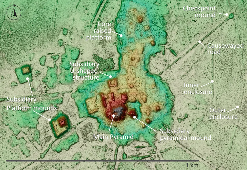
It’s not possible to show a lidar image of these four different types of sites interconnecting because they are too far apart for the resolution available, but the image below of a primary settlement known as Loma Cotoca shows the kinds of things we are now documenting.
It features some very impressive civic-ceremonial architecture: conical pyramids over 20 metres tall and U-shaped structures that may have acted as areas for public gatherings for speeches or ceremonies. These were built on top of man-made platforms rising as much as five metres off the ground and extending over 20 hectares. To be clear, this is all still hiding under the forest, but the lidar data reveals the shape, height and layout of what lies below.
The volume of earth moved to create this architecture would have rivalled – and in some cases exceeded – that of well known Andean monuments such as Akapana a few hundred miles to the south-west on the other side of the Andes. Akapana was the epicentre of the Tiwanaku empire that dominated the southern Andes between about AD600 and 1000.
Akapana pyramid in Tiahuanaco o Tiwanaku, Bolivia.Wikimedia, CC BY-SA
Yet where monuments like Akapana were surrounded by classic, compact bounded cities with thousands of inhabitants, the Casarabe equivalent was completely different. This was dispersed, low-density living amid extensive green space – a form of tropical urbanism that challenges longstanding assumptions about this area as sparsely populated and only lightly modified. It invites comparison with other low-density tropical urban landscapes such as the Maya in central America and the Angkor in latter day Cambodia.
Equally important is the coherence of the Casarabe system. The settlements are rarely isolated, part of a tightly connected network with shared water-management systems. It was clearly all planned and coordinated, designed not only as living spaces but for integrating the population across the region.
We can see that the Casarabe were sustained by drained-field agriculture: the canals were dug to make the land viable for planting during the wet season. The most prominent crop was maize, but there was a remarkable diversity of other produce. This was all embedded within a landscape that was engineered through reservoirs and farm ponds, which helped the Casarabe sustain cultivation and maintain access to water through the dry season in this extremely seasonal environment.
Also very noticeable is the fact that all the major architectural features and burial sites are oriented north-north-west. This suggests these people may have been led by cosmology, with important celestial bodies or regions of the night sky serving as symbolic reference points – hinting at a world where infrastructure, settlement and belief were inseparable.
Rethinking the Amazon
The Casarabe culture covered much less than 1% of Amazonia, which is the whole tropical interior of South America, spanning close to half of the entire continent. For much of the 20th century, this vast area was viewed by archaeologists as an environment that was limiting for human existence.
Poor soils, scarce game, extreme El Niño floods and droughts, and the challenges of tropical disease were all thought to constrain human populations to small, wandering groups living off the land as best they could. Large, settled societies – let alone towns or cities – were considered unlikely, if not impossible.
This view began to shift in the late 20th century for several reasons. Archaeologists realised that Amazonian people had been domesticating a diversity of plants since the end of the Ice Age. They manufactured some of the earliest ceramics in the Americas, and also devised soils known as Amazonian Dark Earths, which combined charcoal, bone and waste materials with the existing poor-quality soil to make it fertile enough for widespread farming.
It also became apparent that just like the Casarabe people, many other cultures across Amazonia had reclaimed vast expanses of seasonally flooded savannahs over several thousand years to create raised and drained field systems.
These discoveries were evidence of long-term settlement and landscape management far beyond what was previously thought possible. It meant Amazonia was not simply a backdrop to human activity; much of the landscape was shaped over the last 13 millennia by the people who lived there.
Enter lidar
Like lasers in the sky, lidar technology has accelerated this transformation in our understanding. The digital process feels near-magical, a “vegetation removal algorithm” that reveals the secrets below.
In practice, however, working with lidar in Amazonia is anything but straightforward. Running such a project here, as I have done, can feel like one of the greatest emotional rollercoasters in field archaeology. It’s all anticipation, frustration and sudden revelation – only comparable, perhaps, with shipwreck exploration.
Depending on what technology is available and most suitable for exploring a particular area, I’ve worked with lidar attached to drones, aeroplanes and helicopters. I’ve learned through trial and error that the technology is only as effective as the logistics and personalities behind it – above all on one occasion when we were trying to integrate a Hungarian lidar sensor with a Brazilian drone.
Above: the ‘Experimental’ drone; below: the moment it finally worked – the smiles in the control station say it all.Jose Iriarte, CC BY-SA
Lidar can perform beautifully one day and fail the next, depending on the equipment, weather, terrain, batteries, communications and the sheer difficulty of operating in remote Amazonian conditions.
Flights must be carefully planned in remote areas with limited infrastructure, where convective clouds, smoke from fires, wind and even vultures riding thermals can disrupt data acquisition. You have to arrange fuel in advance and improvise landings wherever a safe clearing can be found. Here’s our team refuelling a lidar helicopter in the football field of a small village in Acre state, western Brazil:
You also have to do constant troubleshooting with the technology, such as making sure it’s calibrated correctly and that the data from different flight paths all aligns. What appears in the final images as a seamless “removal” of the forest is, in reality, the product of improvisation, negotiation and persistence.
But given all these challenges, it makes the first successful images all the more powerful when they finally appear. The reward is that we’re finally finding the “lost civilisation” that explorers like Percy Fawcett were searching for a century ago, but by cajoling a drone rather than battering through jungle.
Incidentally, this technology also has important uses beyond archaeology. It can help people to locate and harvest crops like rubber or açaí palm fruits without having to clear so much rainforest. It is also used by pioneering projects such as Amazonia Revelada, which helps Indigenous and traditional people of the Amazon to prove their historic presence within an area to ward off modern commercial interests like loggers or farmers, while also protecting the living history and nature embedded in these landscapes.
Other lidar discoveries
Lidar surveys by French and Ecuadorian archaeologists have revealed that the Llanos de Moxos was certainly not the only example of large-scale, highly integrated society in Amazonia. The Upano Valley, which covers some 300-600km² on the mountainous forest of the Ecuadorian eastern flanks of the Andes, offers another striking example – this time from between about 500BC and AD600–700.
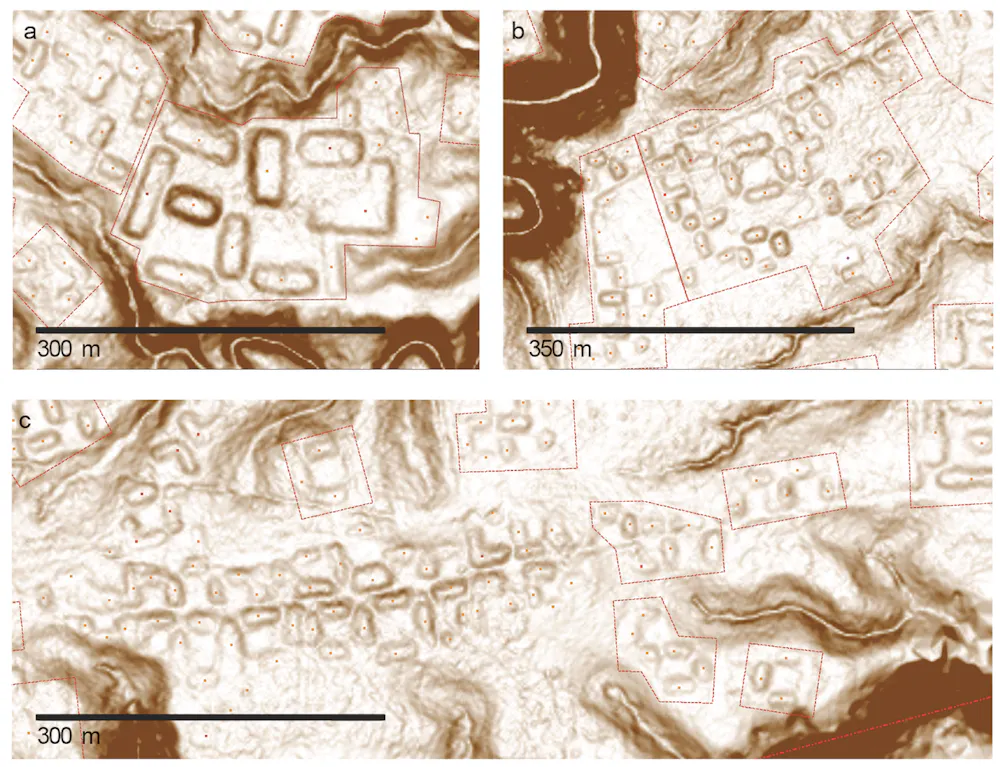
In Upano, archaeologists have been able to map a vast network of settlements connected by extensive road systems, with large platforms and clusters of buildings arranged in organised layouts across a broad area.
What stands out is not just the scale – thousands of structures – but the rigour of the planning. The settlements didn’t just grow randomly, but as part of a deliberate design: we see straight lines of flat-topped platforms laid out in repeating rows and connected by straight paths that cut cleanly across the landscape, as you can see below.
Lidar footage of settlements in the Upano Valley.Jose Iriarte, CC BY-SA
Again, this is not urbanism in the conventional sense of dense, continuous occupation. There would have been none of the vertical stacking of buildings that you’d get in European settlements, and there were also green spaces between platform complexes – much more like a forest city.
Like the Casarabe region, this is a distributed settlement pattern that is both open and highly structured, but the arrangement is much more compact. This reflects the limited flat space available on the upper terraces of the Upano River, which rise up to 100 metres above the surrounding landscape.
Elsewhere in Amazonia, we see more variations. In the Upper Xingu of central Brazil, interconnected settlements were arranged around a shared ceremonial and road network, again suggesting a regionally coordinated social world.
Further north, the Tairona people of the Sierra Nevada de Santa Marta in present-day Colombia built terraced stone towns in the mountains, linked by paved paths. This was a form of urbanism shaped entirely by the demands of steep, high-altitude terrain. Below is a lidar image of one area in this region, with the platforms that would have housed the settlements marked in yellow. Below that, you can see what the platforms look like.
Above: lidar image of settlements at Teyuna-Ciudad Perdida in yellow; below: an actual shot of the platforms that housed the settlements.Daniel Osorio, CC BY-SA
In western Amazonia, Acre adds another important variation. From around AD1–1000, people built large ditched enclosures, or geoglyphs, mainly in the south-eastern part of this region along the upper Purus River. These were square, circular, hexagonal or octagonal mounds, often 1-3 hectares in size, with ditches up to four metres deep. These were probably used as ceremonial gathering places rather than permanent settlements.
After about AD1000, these were followed by what we call circular mound villages, occupied until around AD 1650–1700. They featured rings of mounds around central plazas and straight roads radiating out like the rays of the Sun, often built to align with the four main compass points. These “Sun villages” were true settlements, and formed interconnected networks across the southern rim of Amazonia. You can see an example in the lidar image below.
Lidar image of circular mound village Dona Maria at Acre, Brazil.Jose Iriarte, CC BY-SA
Taken together, these discoveries fundamentally reshape our understanding of Amazonia. We now see a mosaic of managed landscapes, engineered environments and, in some cases, city-scale societies. What unites them is not a shared blueprint but a shared impulse: the organisation of people, space and movement across large landscapes in ways that were deliberate, durable and distinctly their own.
To stress, Amazonia was not uniformly dense or urban. It supported a diversity of types of settlements, from dispersed networks like Moxos to tighter grids like Upano, each of them adapted to local ecological conditions. They shared a low-density urbanism, in the sense of large, interconnected populations without the density of classic cities.
What we still don’t know
How were these societies organised politically and socially? How did they interact with variations in the climate and environment, ranging from the heavy rainfalls and droughts caused by El Niño to rivers forging new routes that could move them away from a settlement within a few generations?
What, if any, connections existed with mountain societies in the Andes? And perhaps most importantly, since both the Casarabe and Upano ceased to build monuments after 1492, what led to their transformation or decline before the arrival of Europeans?
There is active debate between archaeologists over whether these societies transformed because of environmental stress, internal political change, or shifts in things like trade routes or migration.
In the Llanos de Moxos, one possibility is that a prolonged period of climate change affected the Casarabe water-management systems that were so critical to feeding this thriving society. In the Upano Valley, volcanic eruptions and earthquakes may have disrupted settlements and agriculture, although it’s unclear whether that could have led to the area being abandoned.
It seems likely that as we uncover new things, it will reveal more and more integration between different societies. What we are seeing now in Amazonia is much like looking at a satellite image of a country at night: bright, isolated clusters of light – cities that appear disconnected. But as we continue to expand our coverage and fill in the gaps, I think this will change.
What now appear as isolated clusters may also resolve into extensive networks. For example a study across the southern rim of Amazonia has predicted that the kinds of settlement mounds that have been identified so far are likely to occur across about 400,000km², supporting an estimated regional population of roughly 500,000 to 1 million people in the era before the Europeans arrived.
Entire regions may emerge as previously unrecognised centres of population and landscape management. This could be particularly so for the Llanos de Moxos. The whole area covers as much as 200,000km², depending on where you draw the boundaries, stretching into Brazil and even Peru. It is often divided into several apparently distinct cultural regions — the Casarabe (aka the monumental mound region), and then two others called the platform ridge and zanjas (ditches) regions.
As lidar coverage expands and more archaeological work is conducted, we may begin to understand how these societies were economically specialised. We know, for example, that the fortified villages of the zanjas region had fish weirs spanning hundreds of miles that were capable of capturing vast quantities of migratory fish. The platform ridge region consisted of large drained fields, which could potentially produce surpluses of maize. It is conceivable that these belonged to a broader network that supported the more complex Casarabe centres.
Or perhaps – who knows – the relationships were more fluid and reciprocal. For now, the question remains open. But it is precisely this possibility of deep regional integration that lidar is beginning to bring into view. In time, we may even begin to identify Casarabe outposts scattered across the Llanos de Moxos.
What happens next
There’s still a huge amount to be done with lidar. Vast areas, particularly in the Ecuadorian and Peruvian Amazon – remain unexplored. One recent study suggested that there could be more than 10,000 more urban structures of the kind I’ve been describing still hidden throughout Amazonia, all of them dating from pre-European times.
Looking ahead 20 years, it is likely that our map of Amazonia will look very different. One promising technology is satellite-based lidar systems, which could provide broader, though less detailed, datasets across large areas. Advances in machine learning are also beginning to help us identify archaeological features within massive datasets, speeding up a labour-intensive process.
Against this, there are time pressures in some places. Llanos de Moxos, for instance, is unfortunately in rapid transition. The very ground that holds the traces of ancient networks is being transformed by mechanised agriculture and large-scale terraforming for rice cultivation and pastures.
We also need to keep reminding ourselves that lidar is only the first step. What really matters is how it’s brought together with other lines of evidence. Most sites discovered by lidar have yet to be excavated, so we’ll have to do much of that, looking for everything from bones and plants to ceramics and weapons.
So far, most excavation has been in the Casarabe area of the Llanos de Moxos. The reason, for instance, that we know the culture lived primarily on maize was through the discovery of over 60 human skeletons, which underwent carbon isotope analysis. The same research paper also analysed excavated duck bones to show that the Casarabe were feeding them maize too, suggesting animal domestication in a continent that was not generally known for it.
Another fascinating Casarabe find is a single buried skeleton who may have been a leader, because he had a collar of jaguar teeth around his neck. He was also wearing ear pieces made of armadillo shell, studded with mottled blue stones called sodalite – it’s not clear what these were for.
Male burial in Loma Salvatierra, Llanos de Moxos, shows: a) plate of cooper; b) earpieces with pearls of sodalite and armadillo shell; c) a collar of jaguar teeth; d) shell beads; e) bracelet of shell.Heiko Prümers/Jose Iriarte, CC BY-SA
We’ll also need to obtain more precise dates for key events using techniques like radiocarbon dating, and more pinpoint accurate environmental data to help support theories about ancient changes to the climate – as opposed to the wider regional information we’ve tended to rely on until now. Lake sediments are great environmental archives, preserving evidence of things like vegetation change and landscape disturbance.
Also important is comparing genetic data from excavated bones with people who live in these areas today – in dialogue and collaboration with local communities whose histories, memories and knowledge are essential to understanding these landscapes.
It’s all a question of how lidar is brought together with all this other evidence. The most convincing reconstructions will come from the convergence of all of these. One further major challenge ahead, however, will be to bridge the gap between scientific reconstructions and how past peoples understood and inhabited their world. Archaeology is increasingly rich in data, but we have to relate it to lived experience.
That is no easy feat, but it is essential if we are to move from mapping past worlds to understanding them. Crucially, Amazonia – with its rich, still-vibrant Indigenous societies and ethnographic record – offers an exceptional opportunity to do this, providing rare continuities through which to anchor and critically engage our interpretations of the past.
Lessons for today
My own sense is that we will move towards a view of Amazonia not as an exception, in line with the old view that the people lived within an untouched paradise, but as part of a broader pattern of human-environment interaction. The rainforest will be understood not only as a biological system, but as a historical one – shaped, in part, by the people who lived within it.
This does not mean the Amazonian people who simply lived “in harmony” with nature; the evidence points to something more interesting. Although Amazonian societies developed complex, and at times intensive, forms of land use, the evidence consistently shows that they often did so while maintaining continuous forest cover. Far from the large-scale deforestation that we might assume was necessary for such elaborate forms of human life, their practices created mosaics of managed forest, gardens, orchards, wetlands and settlement areas.
We know partly from lake sediment data that people enriched the forests with species that provided food, building materials, medicines and other resources, from açaí and cacao to palms, cinchona and copaiba. The fact that some of these species endure today suggests that past land use left lasting ecological legacies.
Amazonian açaí is one of numerous species that are not prevalent by accident.Guentermanaus
In the context of today’s climate crisis, the long-term balance that these people achieved offers a powerful lesson: it is possible to sustain complex societies without destroying the forest, if land use is guided by principles that integrate ecological knowledge, cultural values and a commitment to the continuity of the living landscape.
What lies beneath the Amazon is not just a hidden past. It is a reminder that even the most seemingly untouched landscapes can carry deep histories, waiting – sometimes just beneath our feet – to be revealed.
This article features references to books that have been included for editorial reasons, and may contain links to bookshop.org. If you click on one of the links and go on to buy something from bookshop.org The Conversation UK may earn a commission.
To hear about new Insights articles, join the hundreds of thousands of people who value The Conversation’s evidence-based news. Subscribe to our newsletter.
José Iriarte receives funding from the European Research Council, the Arts and Humanities Research Council, the British Academy, National Geographic and the Wenner-Gren Foundation for Anthropological Research.

 Login